Swainhill Dingle

Wood, Forest in Herefordshire

England

Swainhill Dingle

Edge of Dudale's Wood Wheat crop in shot was of 2008 vintage; belated upload in 2012.
Edge of Dudale's Wood Credit: Jonathan Billinger

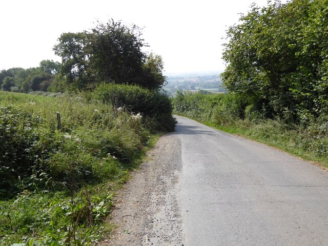
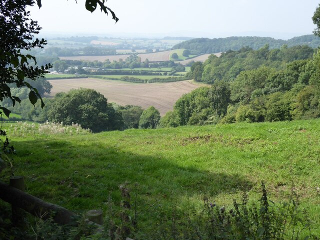
Swainhill Dingle is a picturesque woodland located in the county of Herefordshire, England. Nestled in the heart of the countryside, this enchanting forest covers an area of approximately 100 acres and offers a tranquil retreat for nature enthusiasts and outdoor lovers alike.

The dingle, a local term for a small, steep-sided valley, is characterized by its dense canopy of ancient trees, predominantly oak and beech. These majestic giants provide a sheltered and shady environment, perfect for leisurely strolls or peaceful picnics. The forest floor is adorned with a rich carpet of wildflowers, ferns, and mosses, creating a vibrant tapestry of color throughout the year.

Swainhill Dingle offers a variety of walking trails, ranging from shorter routes suitable for families with young children to longer, more challenging paths for avid hikers. The well-maintained trails wind their way through the dingle, following the natural contours of the land and offering glimpses of the surrounding countryside at various viewpoints.

The forest is also home to a diverse array of wildlife, including deer, foxes, badgers, and an abundance of bird species. Nature enthusiasts can observe and appreciate the delicate balance of the ecosystem, with opportunities for birdwatching and animal spotting throughout the year.

Visitors to Swainhill Dingle can enjoy the peaceful serenity of the woodland, reconnecting with nature and escaping the hustle and bustle of everyday life. It is a cherished local gem, providing a haven for both wildlife and humans alike.

If you have any feedback on the listing, please let us know in the comments section below.

Swainhill Dingle Images

Images are sourced within 2km of 52.164171/-2.6230467 or Grid Reference SO5751. Thanks to Geograph Open Source API. All images are credited.

Edge of Dudale's Wood Wheat crop in shot was of 2008 vintage; belated upload in 2012.
Edge of Dudale's Wood
Wheat crop in shot was of 2008 vintage; belated upload in 2012.
Geographer and welcoming committee The only other contributor to this gridsquare (to date) is pictured with two furry friends approaching Wootton Farm with the landowner's permission.
Geographer and welcoming committee
The only other contributor to this gridsquare (to date) is pictured with two furry friends approaching Wootton Farm with the landowner's permission.
Stone farm Newish buildings, road and fence.
Stone farm
Newish buildings, road and fence.
Farm road to Wootton Farm The refuse collection on its way. Dudale and Wootton Woods stand out.
Farm road to Wootton Farm
The refuse collection on its way. Dudale and Wootton Woods stand out.
Pencombe Cross Turn left for Pencombe.
Pencombe Cross
Turn left for Pencombe.
Marsh Court Companion winter shot to <a href="https://www.geograph.org.uk/photo/202552">SO5851 : Marsh Court</a>.
Marsh Court
Companion winter shot to SO5851 : Marsh Court.
Forage crop Field south of Marsh Court.
Forage crop
Field south of Marsh Court.
Bitterley Hyde Viewed from the ridge road.
Bitterley Hyde
Viewed from the ridge road.
Old oak in a field East of Bitterley Hyde.
Old oak in a field
East of Bitterley Hyde.
Stonehouse Farm Looks to be disused as at December 2014.
Stonehouse Farm
Looks to be disused as at December 2014.
Small coppice at Stonehouse Farm They look like birch.
Small coppice at Stonehouse Farm
They look like birch.
December field entrance Muddy of course; view to Westfields Wood in the distance.
December field entrance
Muddy of course; view to Westfields Wood in the distance.
Ridge road A short length of this road intersects the north-west corner of the square.
Ridge road
A short length of this road intersects the north-west corner of the square.
Poplar row near Lower Hope Combs Hill Wood can be seen beyond.
Poplar row near Lower Hope
Combs Hill Wood can be seen beyond.
Treescape at Lower Hope Conifers and willows, plus a young beech on its own to the right.
Treescape at Lower Hope
Conifers and willows, plus a young beech on its own to the right.
Steep country road Steep country road above Lower Hope near Ullingswick.
Steep country road
Steep country road above Lower Hope near Ullingswick.
Farmland near Ullingswick
Entrance to Wootton Farm Cattle grid at the entrance to the long drive Wootton Farm, which can be seen in the middle distance near the centre of the picture.  Silage has been cut in the field on the left, the crop in the field on the right is potatoes which are ready for lifting.
Entrance to Wootton Farm
Cattle grid at the entrance to the long drive Wootton Farm, which can be seen in the middle distance near the centre of the picture. Silage has been cut in the field on the left, the crop in the field on the right is potatoes which are ready for lifting.
Show me another place!

Swainhill Dingle is located at Grid Ref: SO5751 (Lat: 52.164171, Lng: -2.6230467)

Unitary Authority: County of Herefordshire

Police Authority: West Mercia

What 3 Words

///circulate.successor.rejoiced. Near Moreton Jeffries, Herefordshire

Related Wikis

Pencombe with Grendon Warren

Pencombe with Grendon Warren is a civil parish in the county of Herefordshire, England. The parish was created in 1895 from the parishes of Pencombe and...

Cornett, Herefordshire

Cornett is a hamlet in the English county of Herefordshire. It lies on the main A417 road southeast of the town of Leominster. == External links == Map...

Pencombe

Pencombe is a village and former civil parish, now in the parish of Pencombe with Grendon Warren, in Herefordshire, England. The village is 3.5 miles...

Little Cowarne

Little Cowarne is a village and civil parish in the county of Herefordshire, England, and is 9 miles (14 km) north-east from the city and county town of...

Have you been to Swainhill Dingle?

Leave your review of Swainhill Dingle below (or comments, questions and feedback).