Constantine Bay

Settlement in Cornwall

England

Constantine Bay

Trevose Head Trig Pillar
Trevose Head Trig Pillar Credit: Tony Houlihan

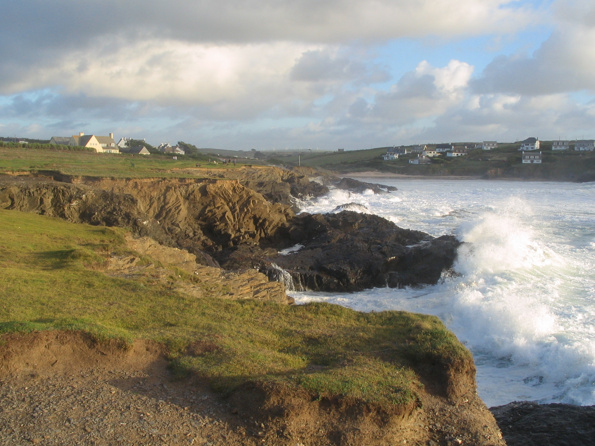
Constantine Bay is a picturesque coastal village located on the north coast of Cornwall, England. Situated approximately five miles west of Padstow, this small village is renowned for its stunning sandy beach, rugged cliffs, and scenic beauty.

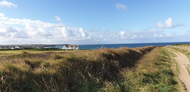
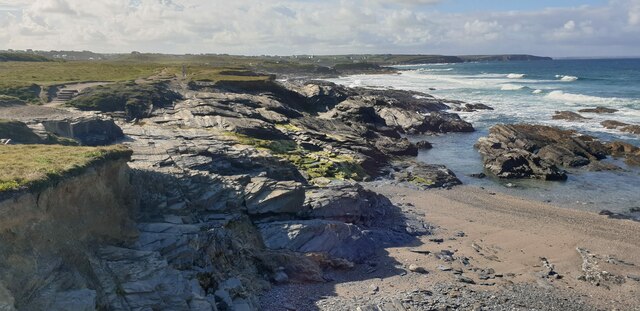
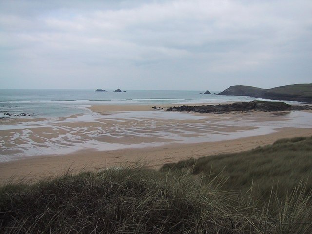
The beach at Constantine Bay stretches for nearly a mile, providing a haven for beach lovers, surfers, and nature enthusiasts alike. With its golden sands and clear turquoise waters, it is considered one of the most beautiful beaches in Cornwall. The bay is flanked by towering cliffs, offering breathtaking views and a sense of seclusion.

The village itself is small and peaceful, with a handful of houses, holiday cottages, and a local pub. Although there are limited amenities in Constantine Bay, visitors can find all the necessary supplies and services in the nearby town of Padstow.

Constantine Bay is a popular destination for surfers due to its consistent waves and favorable wind conditions. The beach is also a haven for wildlife, with numerous species of birds and marine life inhabiting the area. During low tide, rock pools are exposed, providing an opportunity for exploration and discovering various marine creatures.

For those seeking outdoor activities, the South West Coast Path runs through Constantine Bay, offering stunning walks along the coastline. The area is also known for its excellent golf courses, providing golf enthusiasts with a chance to enjoy a round amidst breathtaking natural surroundings.

In summary, Constantine Bay is a tranquil and scenic village in Cornwall, boasting a stunning beach, rugged cliffs, and an abundance of natural beauty. It is an ideal destination for beach lovers, surfers, and those seeking a peaceful coastal retreat.

If you have any feedback on the listing, please let us know in the comments section below.

Constantine Bay Images

Images are sourced within 2km of 50.53356/-5.025436 or Grid Reference SW8574. Thanks to Geograph Open Source API. All images are credited.

Trevose Head Trig Pillar
Trevose Head Trig Pillar - Flush bracket S1735 Trevose Head Triangulation Pillar - Flush bracket S1735
Trevose Head Trig Pillar - Flush bracket S1735
Trevose Head Triangulation Pillar - Flush bracket S1735
The road to Trevose Head
Offshore Rocks and the Lighthouse at Trevose Head Looking past the Quies Rocks towards the Trevose Lighthouse a Grade II listed building dating from 1847 (Historic England List Entry No:1212769 <span class="nowrap"><a title="https://historicengland.org.uk/listing/the-list/list-entry/1212769?section=official-list-entry" rel="nofollow ugc noopener" href="https://historicengland.org.uk/listing/the-list/list-entry/1212769?section=official-list-entry">Link</a><img style="margin-left:2px;" alt="External link" title="External link - shift click to open in new window" src="https://s1.geograph.org.uk/img/external.png" width="10" height="10"/></span> ).
Offshore Rocks and the Lighthouse at Trevose Head
Looking past the Quies Rocks towards the Trevose Lighthouse a Grade II listed building dating from 1847 (Historic England List Entry No:1212769 LinkExternal link ).
Trevose Lighthouse Trevose Head Lighthouse was built by Trinity House in 1847 as a guide for vessels in the Bristol Channel. It is situated on the north west extremity of Trevose Head, with gigantic cliffs of grey granite rising sheer from the sea to a height of 150 feet or more. The area, like so much of the Devon and Cornwall coastline, is frequently obscured by sea mists (<span class="nowrap"><a title="https://www.trinityhouse.co.uk/lighthouses-and-lightvessels/trevose-head" rel="nofollow ugc noopener" href="https://www.trinityhouse.co.uk/lighthouses-and-lightvessels/trevose-head">Link</a><img style="margin-left:2px;" alt="External link" title="External link - shift click to open in new window" src="https://s1.geograph.org.uk/img/external.png" width="10" height="10"/></span> Trinity House).

The lighthouse is a Grade II listed building (Historic England List Entry No:1212769 <span class="nowrap"><a title="https://historicengland.org.uk/listing/the-list/list-entry/1212769?section=official-list-entry" rel="nofollow ugc noopener" href="https://historicengland.org.uk/listing/the-list/list-entry/1212769?section=official-list-entry">Link</a><img style="margin-left:2px;" alt="External link" title="External link - shift click to open in new window" src="https://s1.geograph.org.uk/img/external.png" width="10" height="10"/></span> ).
Trevose Lighthouse
Trevose Head Lighthouse was built by Trinity House in 1847 as a guide for vessels in the Bristol Channel. It is situated on the north west extremity of Trevose Head, with gigantic cliffs of grey granite rising sheer from the sea to a height of 150 feet or more. The area, like so much of the Devon and Cornwall coastline, is frequently obscured by sea mists (LinkExternal link Trinity House). The lighthouse is a Grade II listed building (Historic England List Entry No:1212769 LinkExternal link ).
St Constantine's Well
St Constantine well
St Constantine well
Walk Towards Booby's Bay A view from the path from the car park down to Booby's Bay.
Walk Towards Booby's Bay
A view from the path from the car park down to Booby's Bay.
Fields at Booby's Bay The fields to the north of the path down to Booby's Bay from the car park. You can just see a glimpse of the sea on the horizon.
Fields at Booby's Bay
The fields to the north of the path down to Booby's Bay from the car park. You can just see a glimpse of the sea on the horizon.
The Sea at Booby's Bay Looking down from the cliff at the sea breaking on rocks at Booby's Bay.
The Sea at Booby's Bay
Looking down from the cliff at the sea breaking on rocks at Booby's Bay.
High Tide at Booby's Bay Looking across Booby's Bay towards Constantine Bay and Treyarnon.
High Tide at Booby's Bay
Looking across Booby's Bay towards Constantine Bay and Treyarnon.
Cliff Path at Booby's Bay A cliff top path at Booby's Bay, looking out over the breaking waves.
Cliff Path at Booby's Bay
A cliff top path at Booby's Bay, looking out over the breaking waves.
Rocks at Booby's Bay The sea breaking on rocks at Booby's Bay.
Rocks at Booby's Bay
The sea breaking on rocks at Booby's Bay.
Gentle Cliffs at Booby's Bay The sea breaking on the cliffs and rocks at Booby's Bay.
Gentle Cliffs at Booby's Bay
The sea breaking on the cliffs and rocks at Booby's Bay.
Rocks towards Treyarnon, Booby's Bay Viewed from the very edge of the cliff, the rocks at Booby's Bay, looking towards Treyarnon on the horizon.
Rocks towards Treyarnon, Booby's Bay
Viewed from the very edge of the cliff, the rocks at Booby's Bay, looking towards Treyarnon on the horizon.
Booby's Bay from Cliff Edge Rocks and steep pebble beach at Booby's Bay from the edge of the cliff.
Booby's Bay from Cliff Edge
Rocks and steep pebble beach at Booby's Bay from the edge of the cliff.
Leaving Towan village
Constantine Bay Stores
Show me another place!

Constantine Bay is located at Grid Ref: SW8574 (Lat: 50.53356, Lng: -5.025436)

Unitary Authority: Cornwall

Police Authority: Devon and Cornwall

What 3 Words

///neckline.fillings.snipped. Near Padstow, Cornwall

Related Wikis

Booby's Bay

Booby's Bay is a sandy beach near Padstow, Cornwall, England, UK. During World War I, the three masted sailing ship Carl of the German navy was beached...

Treyarnon

Treyarnon (Cornish: Tre Arnen, meaning Garnen's farm) is a hamlet west of St Merryn in Cornwall, England, UK near Padstow. Treyarnon Beach is a small beach...

Constantine Bay

Constantine Bay (Cornish: Eglos Costentin, meaning church of St Constantine) is a village and beach on the Atlantic coast of north Cornwall, England, United...

Trevose Golf & Country Club

Trevose Golf & Country Club is a 27-hole golf club in Cornwall, England which has hosted many of the leading amateur golf tournaments in Britain, including...

Nearby Amenities

Located within 500m of 50.53356,-5.025436
Source: PGS
Lat/Long: 50.536717/-5.023514
Source: PGS
Lat/Long: 50.5361885/-5.0226932
Source: PGS
Lat/Long: 50.534632/-5.0224062
Source: PGS
Lat/Long: 50.5326969/-5.0222801
Source: PGS
Lat/Long: 50.5322332/-5.0224089
Source: PGS
Lat/Long: 50.5319228/-5.0226825
Source: PGS
Lat/Long: 50.5315802/-5.0229212
Source: PGS
Lat/Long: 50.5314557/-5.0233865
Source: PGS
Lat/Long: 50.5312519/-5.0236702
Source: PGS
Lat/Long: 50.5311479/-5.0238231
Source: PGS
Lat/Long: 50.5309136/-5.024898
Barrier: stile
Material: stone
Step Count: 2
Stile: stepover
Lat/Long: 50.5301999/-5.0247017
Toilets
Fee: yes
Wheelchair: yes
Lat/Long: 50.5311156/-5.0221088
Constantine Island
Place: locality
Lat/Long: 50.53669/-5.02511
Bench
Backrest: yes
Lat/Long: 50.5306775/-5.0240617
Bench
Backrest: yes
Survey Date: 2023-02-12
Lat/Long: 50.5295585/-5.0258848
Life Ring
Emergency: life_ring
Survey Date: 2023-02-12
Lat/Long: 50.532231/-5.0225678
Bench
Backrest: yes
Survey Date: 2023-02-12
Lat/Long: 50.5312874/-5.0231088
Bench
Backrest: yes
Survey Date: 2023-02-12
Lat/Long: 50.5312533/-5.0229182
Bench
Backrest: yes
Survey Date: 2023-02-12
Lat/Long: 50.5298054/-5.025379
Bench
Backrest: yes
Survey Date: 2023-02-12
Lat/Long: 50.5295938/-5.0257847
Life Ring
Emergency: life_ring
Survey Date: 2023-02-12
Lat/Long: 50.5373808/-5.0246237
Bench
Backrest: yes
Survey Date: 2023-02-12
Lat/Long: 50.5312247/-5.022765
Bench
Backrest: yes
Survey Date: 2023-02-12
Lat/Long: 50.5312078/-5.0226443
Bench
Backrest: yes
Survey Date: 2023-02-12
Lat/Long: 50.5303531/-5.02505
Bench
Backrest: yes
Survey Date: 2023-02-12
Lat/Long: 50.5297278/-5.0255919
Bench
Backrest: yes
Survey Date: 2023-02-12
Lat/Long: 50.5293503/-5.0258672
Leisure: picnic_table
Survey Date: 2023-02-12
Lat/Long: 50.5299668/-5.0252334
Bench
Backrest: yes
Survey Date: 2023-02-12
Lat/Long: 50.5293883/-5.026059
Phone
Emergency: phone
Lat/Long: 50.5314108/-5.0229235
The data included in this document is from www.openstreetmap.org. The data is made available under ODbL.

Have you been to Constantine Bay?

Leave your review of Constantine Bay below (or comments, questions and feedback).