Judeland Wood

Wood, Forest in Lancashire Chorley

England

Judeland Wood

Charnock Richard Crematorium Memorial garden
Charnock Richard Crematorium Memorial garden Credit: David Dixon

Judeland Wood, located in the county of Lancashire, England, is a charming forested area that offers a serene and picturesque escape for nature enthusiasts. Covering a vast expanse of approximately 200 acres, the wood is known for its diverse ecosystem and rich biodiversity.

The wood is predominantly composed of deciduous trees, including oak, birch, and beech, which create a lush canopy, providing shade and shelter for various flora and fauna. The forest floor is adorned with a carpet of wildflowers, adding a burst of color during the spring and summer months.

The wood is crisscrossed by a network of well-maintained walking trails, allowing visitors to explore the area and soak in its natural beauty. These trails cater to all levels of fitness and provide an opportunity to observe the wood's wildlife, such as roe deer, rabbits, and various bird species.

In addition to its natural attractions, Judeland Wood also boasts a small visitor center that provides information about the wood's history, geology, and wildlife. Educational activities and guided walks are often organized, offering visitors an opportunity to learn more about the local ecosystem.

Judeland Wood is a popular destination for outdoor enthusiasts, photographers, and families seeking a peaceful retreat. Its tranquil setting, coupled with its natural beauty and accessibility, makes it an ideal location for those looking to immerse themselves in nature. Whether it's a leisurely stroll, a picnic with loved ones, or simply taking in the sights and sounds of the forest, Judeland Wood offers a rejuvenating experience for all who visit.

If you have any feedback on the listing, please let us know in the comments section below.

Judeland Wood Images

Images are sourced within 2km of 53.659277/-2.6535431 or Grid Reference SD5618. Thanks to Geograph Open Source API. All images are credited.

Charnock Richard Crematorium Memorial garden
Memorial Garden, Charnock Richard Crematorium
The Queens 
The Queen's Hotel on Church Street dates back to the 1860s. It closed in 2009 and was falling into disrepair until it was restored and converted to residential use in 2015. See <span class="nowrap"><a title="http://chorleyinnsandtaverns.blogspot.com/p/queens-hotel.html" rel="nofollow ugc noopener" href="http://chorleyinnsandtaverns.blogspot.com/p/queens-hotel.html">Link</a><img style="margin-left:2px;" alt="External link" title="External link - shift click to open in new window" src="https://s1.geograph.org.uk/img/external.png" width="10" height="10"/></span> for more details.
The Queens
The Queen's Hotel on Church Street dates back to the 1860s. It closed in 2009 and was falling into disrepair until it was restored and converted to residential use in 2015. See LinkExternal link for more details.
Shepherd's Victoria Hall The Ancient Order of Shepherds Friendly Society was formed in 1826 and was quite prominent in Chorley in the late 1800s and early 1900s.

The hall is presently occupied Chorley Fitness Centre and a micro-brewery 

On the right is the bus station.

<a href="https://www.geograph.org.uk/photo/7185639">SD5817 : Shepherd's Victoria Hall: Architectural detail (1)</a>.
<a href="https://www.geograph.org.uk/photo/7185644">SD5817 : Shepherd's Victoria Hall: Architectural detail (2)</a>.
Shepherd's Victoria Hall
The Ancient Order of Shepherds Friendly Society was formed in 1826 and was quite prominent in Chorley in the late 1800s and early 1900s. The hall is presently occupied Chorley Fitness Centre and a micro-brewery On the right is the bus station. SD5817 : Shepherd's Victoria Hall: Architectural detail (1). SD5817 : Shepherd's Victoria Hall: Architectural detail (2).
Shepherd's Victoria Hall: Architectural detail (1) 
Detail on Shepherd's Victoria Hall <a href="https://www.geograph.org.uk/photo/7185596">SD5817 : Shepherd's Victoria Hall</a>.
Shepherd's Victoria Hall: Architectural detail (1)
Detail on Shepherd's Victoria Hall SD5817 : Shepherd's Victoria Hall.
Shepherd's Victoria Hall: Architectural detail (2) 
Detail on Shepherd's Victoria Hall <a href="https://www.geograph.org.uk/photo/7185596">SD5817 : Shepherd's Victoria Hall</a>.
Shepherd's Victoria Hall: Architectural detail (2)
Detail on Shepherd's Victoria Hall SD5817 : Shepherd's Victoria Hall.
Chorley Bus Station
Chorley Bus Station
Chorley Railway Station 
As viewed from the bus station across Shepherd's Way (A6).
Chorley Railway Station
As viewed from the bus station across Shepherd's Way (A6).
Astley Hall The render had just been removed from the brickwork
Astley Hall
The render had just been removed from the brickwork
The Courtyard Formed by the stable block to Astley Hall and Astley Farm
The Courtyard
Formed by the stable block to Astley Hall and Astley Farm
Steely Lane Level Crossing, Chorley – 1971 This crossing has disappeared completely, together with the signal box, the only evidence being some asphalt visible in the foreground of this view <a title="https://www.geograph.org.uk/photo/2786575" href="https://www.geograph.org.uk/photo/2786575">Link</a> . The pedestrian subway on the right does survive.
Steely Lane Level Crossing, Chorley – 1971
This crossing has disappeared completely, together with the signal box, the only evidence being some asphalt visible in the foreground of this view Link . The pedestrian subway on the right does survive.
The Malt 'n' Hops, Chorley This building on Friday Street dates from the 1870s and looks as though it might always have been a pub. In fact, it was for very many years a grocer's shop and subsequently found a variety of uses before being converted to a pub in 1989. Today it is renowned for the quality and range of real ales on offer, winning CAMRA's Central Lancashire pub of the year title in 2017.
The Malt 'n' Hops, Chorley
This building on Friday Street dates from the 1870s and looks as though it might always have been a pub. In fact, it was for very many years a grocer's shop and subsequently found a variety of uses before being converted to a pub in 1989. Today it is renowned for the quality and range of real ales on offer, winning CAMRA's Central Lancashire pub of the year title in 2017.
The Bob Inn, Chorley Occupying what is effectively a stall in Chorley's covered market, this is a particularly small micropub. As it forms part of the market it is closed on Sundays.
The Bob Inn, Chorley
Occupying what is effectively a stall in Chorley's covered market, this is a particularly small micropub. As it forms part of the market it is closed on Sundays.
Ben's Tap & Bottleshop, Chorley This is one of several micropubs in the centre of Chorley and is almost opposite the Bob Inn. It is the brewery tap for Ben's microbrewery and opened in March 2022.
Ben's Tap & Bottleshop, Chorley
This is one of several micropubs in the centre of Chorley and is almost opposite the Bob Inn. It is the brewery tap for Ben's microbrewery and opened in March 2022.
Chapel Street, Chorley Chapel Street connects Chorley town centre with the bus and rail stations; the stretch here is pedestrianised. On the left is a charity shop supporting Cancer Research UK.
Chapel Street, Chorley
Chapel Street connects Chorley town centre with the bus and rail stations; the stretch here is pedestrianised. On the left is a charity shop supporting Cancer Research UK.
Chapel Street, Chorley This stretch of Chapel Street runs immediately to the north of St George's Church. Grosvenor Partners on the left is a wealth management and financial planning firm. The larger building on the corner is Shepherd's Hall that originally belonged to the Shepherd's Guild but now houses a gym and a micropub.
Chapel Street, Chorley
This stretch of Chapel Street runs immediately to the north of St George's Church. Grosvenor Partners on the left is a wealth management and financial planning firm. The larger building on the corner is Shepherd's Hall that originally belonged to the Shepherd's Guild but now houses a gym and a micropub.
St George's Church, Chorley - tower St George's Church was designed by Thomas Rickman, an architect with a particular interest in the Gothic Revival, and built between 1822 and 1825. It was a 'commissioner's church', funded by a grant made available under the Church Building Acts of 1818 and 1824 and administered by the Church Building Commission. The object was to provide churches in the fast-growing urban areas of the industrial revolution and Chorley, a Lancashire mill town, would have been a prime candidate. The building is now grade II* listed. The clock is showing the correct time.
St George's Church, Chorley - tower
St George's Church was designed by Thomas Rickman, an architect with a particular interest in the Gothic Revival, and built between 1822 and 1825. It was a 'commissioner's church', funded by a grant made available under the Church Building Acts of 1818 and 1824 and administered by the Church Building Commission. The object was to provide churches in the fast-growing urban areas of the industrial revolution and Chorley, a Lancashire mill town, would have been a prime candidate. The building is now grade II* listed. The clock is showing the correct time.
The Ale Station, Chorley Taking its name from the nearby rail and bus stations, The Ale Station has adopted the British Transport Commission style of sign over its door. This is one of several micropubs in the immediate vicinity.
The Ale Station, Chorley
Taking its name from the nearby rail and bus stations, The Ale Station has adopted the British Transport Commission style of sign over its door. This is one of several micropubs in the immediate vicinity.
Show me another place!

Judeland Wood is located at Grid Ref: SD5618 (Lat: 53.659277, Lng: -2.6535431)

Administrative County: Lancashire

District: Chorley

Police Authority: Lancashire

What 3 Words

///marble.appeal.being. Near Euxton, Lancashire

Related Wikis

Pestalozzi International Village

Pestalozzi International Foundation (formerly called Pestalozzi Children's Village Trust and then Pestalozzi International Village Trust) is an educational...

Chorley Rural District

Chorley Rural District was a rural district in the administrative county of Lancashire, England from 1894 to 1974. The district was created by the Local...

Lancashire College

Lancashire Adult Learning is an adult education college located in Lancashire, England . Courses offered by the college are aimed primarily at adult learners...

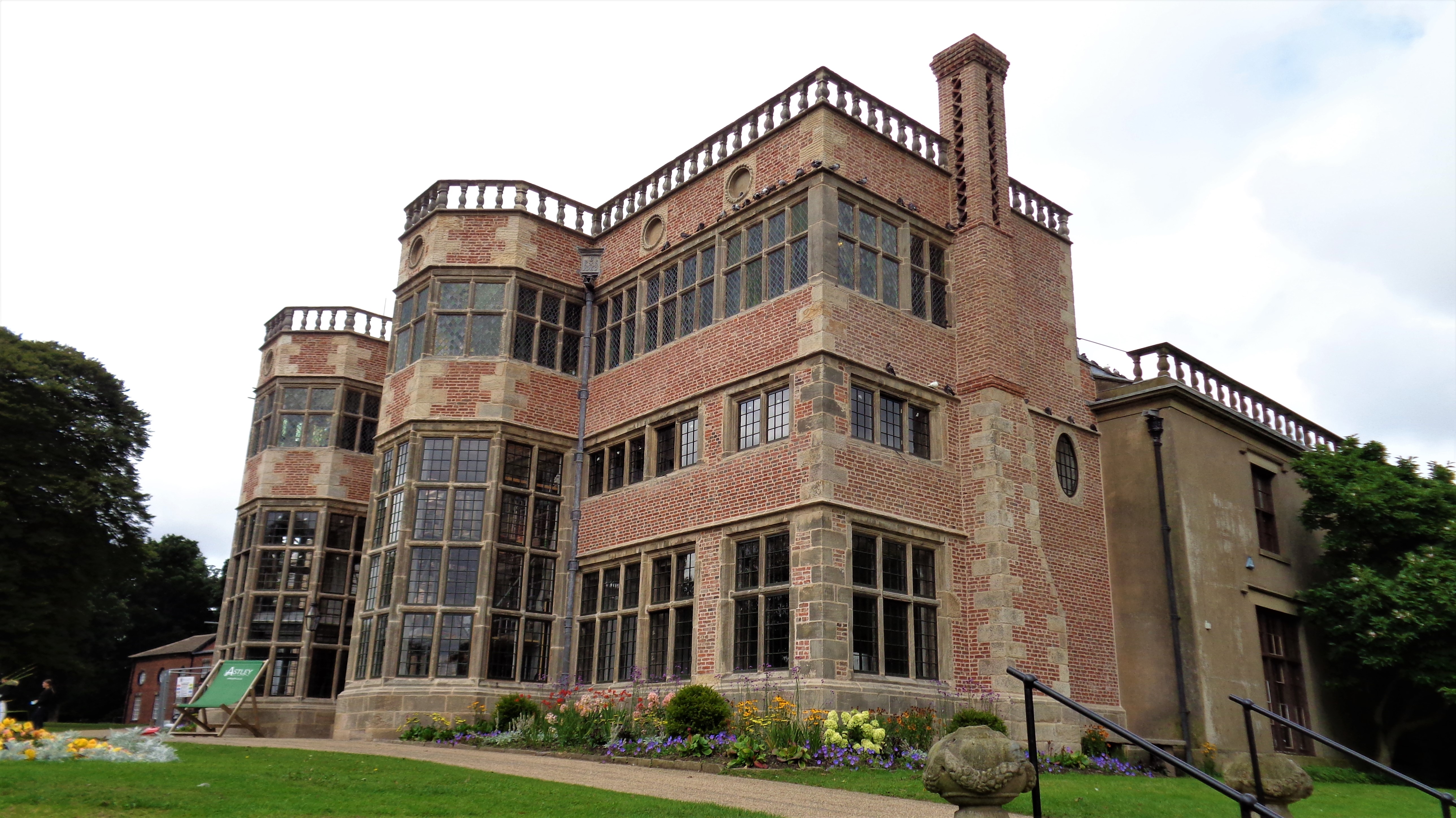
Astley Hall, Chorley

Astley Hall is a country house in Chorley, Lancashire, England. The building is now owned by the town and is known as Astley Hall Museum and Art Gallery...

Parklands High School, Chorley

Parklands High School is a coeducational secondary school with academy status located in Chorley, Lancashire, England. The school has been judged "good...
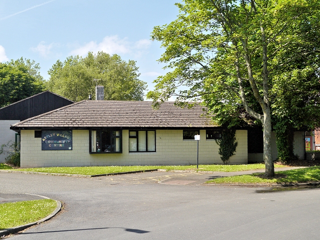
Astley Village

Astley Village is a civil parish in the Borough of Chorley in Lancashire, England, covering a suburb of Chorley. According to the 2011 census, its population...

St Michael's Church of England High School, Chorley

St Michael's is a Church of England secondary school located in the town of Chorley, Lancashire, England. The school is home to 1,200 pupils, and is a...

Euxton Balshaw Lane railway station

Euxton Balshaw Lane is one of two railway stations situated in Euxton , Lancashire, England. It is a local station on the West Coast Main Line on the stretch...

Nearby Amenities

Located within 500m of 53.659277,-2.6535431
Crossing
Crossing: traffic_signals
Crossing Ref: toucan
Lat/Long: 53.6575204/-2.6565029
Source: Yahoo imagery
Lat/Long: 53.6557639/-2.6532054
Source: Yahoo imagery
Lat/Long: 53.6557044/-2.6515126
Source: Yahoo imagery
Lat/Long: 53.6569357/-2.6543761
Source: Yahoo imagery
Lat/Long: 53.6569616/-2.6540995
Source: Yahoo imagery
Lat/Long: 53.6576685/-2.6527397
Source: Yahoo imagery
Lat/Long: 53.657972/-2.6523109
Source: Yahoo imagery
Lat/Long: 53.6582569/-2.6526794
Source: Yahoo imagery
Lat/Long: 53.6582918/-2.6522759
Source: Yahoo imagery
Lat/Long: 53.6583764/-2.6514186
Source: Yahoo imagery
Lat/Long: 53.6587948/-2.6514438
Source: Yahoo imagery
Lat/Long: 53.6585607/-2.6481324
Source: Yahoo imagery
Lat/Long: 53.6584462/-2.6475524
Source: Yahoo imagery
Lat/Long: 53.6575464/-2.6498462
Source: Yahoo imagery
Lat/Long: 53.6575204/-2.6514715
Source: Yahoo imagery
Lat/Long: 53.6559384/-2.6523195
Source: Yahoo imagery
Lat/Long: 53.6560354/-2.6531416
Source: Yahoo imagery
Lat/Long: 53.6584661/-2.6497965
Source: Yahoo imagery
Lat/Long: 53.6585906/-2.6506622
Source: Yahoo imagery
Lat/Long: 53.6594722/-2.6514859
Source: Yahoo imagery
Lat/Long: 53.6593327/-2.6518053
Source: Yahoo imagery
Lat/Long: 53.6592593/-2.6512029
Source: Yahoo imagery
Lat/Long: 53.6588844/-2.65099
Source: Yahoo imagery
Lat/Long: 53.657432/-2.6543053
Source: Yahoo imagery
Lat/Long: 53.6575475/-2.6542115
Source: Yahoo imagery
Lat/Long: 53.6576855/-2.6540915
Source: Yahoo imagery
Lat/Long: 53.657802/-2.654176
Source: Yahoo imagery
Lat/Long: 53.6579191/-2.6544014
Source: Yahoo imagery
Lat/Long: 53.6579663/-2.6546314
Source: Yahoo imagery
Lat/Long: 53.6579846/-2.6549997
Source: Yahoo imagery
Lat/Long: 53.657981/-2.6554044
Source: Yahoo imagery
Lat/Long: 53.6580725/-2.6556539
Source: Yahoo imagery
Lat/Long: 53.6582059/-2.6557719
Source: Yahoo imagery
Lat/Long: 53.6583426/-2.6557359
Source: Yahoo imagery
Lat/Long: 53.6585102/-2.6555988
Source: Yahoo imagery
Lat/Long: 53.6587175/-2.655494
Source: Yahoo imagery
Lat/Long: 53.6588484/-2.6555417
Source: Yahoo imagery
Lat/Long: 53.6590656/-2.6557546
Source: Yahoo imagery
Lat/Long: 53.6591222/-2.6560002
Source: Yahoo imagery
Lat/Long: 53.6592199/-2.6564477
Source: Yahoo imagery
Lat/Long: 53.6594233/-2.6565686
Source: Yahoo imagery
Lat/Long: 53.6596622/-2.6563919
Source: Yahoo imagery
Lat/Long: 53.6597697/-2.6562457
Source: Yahoo imagery
Lat/Long: 53.6599239/-2.6560809
Source: Yahoo imagery
Lat/Long: 53.6602445/-2.6561712
Turning Circle
Source: Yahoo imagery
Lat/Long: 53.6601037/-2.6570137
Source: Yahoo imagery
Lat/Long: 53.6598947/-2.6569615
Source: Yahoo imagery
Lat/Long: 53.6598222/-2.6570681
Source: Yahoo imagery
Lat/Long: 53.6596581/-2.6571495
Source: Yahoo imagery
Lat/Long: 53.6595416/-2.6571158
Source: Yahoo imagery
Lat/Long: 53.6594326/-2.6569922
Turning Circle
Source: Yahoo imagery
Lat/Long: 53.6591944/-2.657217
Turning Circle
Source: Yahoo imagery
Lat/Long: 53.6586624/-2.6567532
Source: Yahoo imagery
Lat/Long: 53.6588035/-2.6564552
Source: Yahoo imagery
Lat/Long: 53.6591578/-2.6562608
Source: Yahoo imagery
Lat/Long: 53.6591379/-2.6556985
Source: Yahoo imagery
Lat/Long: 53.65927/-2.6556278
Source: Yahoo imagery
Lat/Long: 53.6593858/-2.6556205
Source: Yahoo imagery
Lat/Long: 53.6594909/-2.6554737
Turning Circle
Source: Yahoo imagery
Lat/Long: 53.6596191/-2.655211
Turning Circle
Source: Yahoo imagery
Lat/Long: 53.6587918/-2.6548195
Source: Yahoo imagery
Lat/Long: 53.6582673/-2.6540437
Turning Circle
Source: Yahoo imagery
Lat/Long: 53.6584664/-2.653685
Source: Yahoo imagery
Lat/Long: 53.6577125/-2.65359
Source: Yahoo imagery
Lat/Long: 53.6578441/-2.653326
Turning Circle
Source: Yahoo imagery
Lat/Long: 53.6579398/-2.6532423
Turning Circle
Source: Yahoo imagery
Lat/Long: 53.6603357/-2.6539759
Source: Yahoo imagery
Lat/Long: 53.6603449/-2.65357
Source: Yahoo imagery
Lat/Long: 53.6603237/-2.6533657
Source: Yahoo imagery
Lat/Long: 53.6600727/-2.6530651
Source: Yahoo imagery
Lat/Long: 53.6598877/-2.6530203
Source: Yahoo imagery
Lat/Long: 53.6597761/-2.6529039
Source: Yahoo imagery
Lat/Long: 53.6590472/-2.6525075
Source: Yahoo imagery
Lat/Long: 53.6592711/-2.6527845
Source: Yahoo imagery
Lat/Long: 53.6594583/-2.6529111
Source: Yahoo imagery
Lat/Long: 53.6596281/-2.6529423
Source: Yahoo imagery
Lat/Long: 53.659923/-2.6524117
Source: Yahoo imagery
Lat/Long: 53.6600785/-2.6520853
Source: Yahoo imagery
Lat/Long: 53.6602896/-2.6518613
Source: Yahoo imagery
Lat/Long: 53.6606512/-2.651866
Turning Circle
Source: Yahoo imagery
Lat/Long: 53.6596699/-2.6520978
Source: Yahoo imagery
Lat/Long: 53.6593275/-2.6579154
Source: Yahoo imagery
Lat/Long: 53.6601663/-2.6576898
Source: Yahoo imagery
Lat/Long: 53.6606717/-2.657003
Source: Yahoo imagery
Lat/Long: 53.660398/-2.6549827
Source: Yahoo imagery
Lat/Long: 53.6589098/-2.6540708
Source: Yahoo imagery
Lat/Long: 53.6569194/-2.6551368
Source: Yahoo imagery
Lat/Long: 53.6573818/-2.6561058
Source: Yahoo imagery
Lat/Long: 53.6575885/-2.6557759
Source: Yahoo imagery
Lat/Long: 53.6585368/-2.6574764
Source: Yahoo imagery
Lat/Long: 53.6588631/-2.6573668
Source: Yahoo imagery
Lat/Long: 53.6592457/-2.6593325
Source: Yahoo imagery
Lat/Long: 53.6606419/-2.6575502
Source: Yahoo imagery
Lat/Long: 53.6612602/-2.6558372
Source: Yahoo imagery
Lat/Long: 53.6596812/-2.6583374
Source: Yahoo imagery
Lat/Long: 53.6600979/-2.6584085
Source: Yahoo imagery
Lat/Long: 53.6578202/-2.6573447
Source: Yahoo imagery
Lat/Long: 53.6577183/-2.6574045
Source: Yahoo imagery
Lat/Long: 53.6576331/-2.6576951
Source: Yahoo imagery
Lat/Long: 53.6576696/-2.6567915
Source: Yahoo imagery
Lat/Long: 53.657739/-2.6571011
Source: Yahoo imagery
Lat/Long: 53.6593926/-2.6597963
Source: Yahoo imagery
Lat/Long: 53.6594261/-2.6601105
Source: Yahoo imagery
Lat/Long: 53.6595607/-2.660399
Source: Yahoo imagery
Lat/Long: 53.6597381/-2.6602373
Source: Yahoo imagery
Lat/Long: 53.6596982/-2.6599682
Source: Yahoo imagery
Lat/Long: 53.6611776/-2.6586079
Source: Yahoo imagery
Lat/Long: 53.662314/-2.6540568
Source: Yahoo imagery
Lat/Long: 53.662135/-2.6536423
Source: Yahoo imagery
Lat/Long: 53.6606594/-2.6578903
Source: Yahoo imagery
Lat/Long: 53.6594457/-2.6595272
Source: Yahoo imagery
Lat/Long: 53.6607873/-2.6534012
Source: Yahoo imagery
Lat/Long: 53.6607049/-2.6528971
Source: Yahoo imagery
Lat/Long: 53.6606689/-2.6524997
Source: Yahoo imagery
Lat/Long: 53.6607312/-2.649021
Source: Yahoo imagery
Lat/Long: 53.6609841/-2.652799
Source: Yahoo imagery
Lat/Long: 53.661078/-2.6527436
Source: Yahoo imagery
Lat/Long: 53.6611529/-2.6525185
Source: Yahoo imagery
Lat/Long: 53.6613098/-2.6521981
Source: Yahoo imagery
Lat/Long: 53.6615853/-2.6521405
Source: Yahoo imagery
Lat/Long: 53.6617921/-2.652015
Source: Yahoo imagery
Lat/Long: 53.661975/-2.6517465
Source: Yahoo imagery
Lat/Long: 53.6620826/-2.6515259
Source: Yahoo imagery
Lat/Long: 53.6623137/-2.6513801
Source: Yahoo imagery
Lat/Long: 53.6625151/-2.6513729
Source: Yahoo imagery
Lat/Long: 53.6627889/-2.6511338
Turning Circle
Source: Yahoo imagery
Lat/Long: 53.6628136/-2.6501926
Source: Yahoo imagery
Lat/Long: 53.6625255/-2.6504159
Source: Yahoo imagery
Lat/Long: 53.6623721/-2.650578
Source: Yahoo imagery
Lat/Long: 53.6622671/-2.6508965
Turning Circle
Source: Yahoo imagery
Lat/Long: 53.6621188/-2.6520347
Source: Yahoo imagery
Lat/Long: 53.6613202/-2.6533625
Source: Yahoo imagery
Lat/Long: 53.6612188/-2.6565943
Source: Yahoo imagery
Lat/Long: 53.6625495/-2.6534944
Source: Yahoo imagery
Lat/Long: 53.6630801/-2.6529364
Source: Yahoo imagery
Lat/Long: 53.6624107/-2.6529915
Source: Yahoo imagery
Lat/Long: 53.6629822/-2.6521925
Source: Yahoo imagery
Lat/Long: 53.6636148/-2.6524267
Source: Yahoo imagery
Lat/Long: 53.6634556/-2.6516896
Bus Stop
Village Centre
Bus: yes
Naptan AtcoCode: 2500501
Naptan CommonName: Village Centre
Naptan Indicator: by
Naptan NaptanCode: lanawjwt
Naptan Verified: no
Public Transport: platform
Source: survey
Lat/Long: 53.6611284/-2.6472008
Bus Stop
Chancery Road North
Bus: yes
Naptan AtcoCode: 2500DCL3397
Naptan CommonName: Chancery Road
Naptan Indicator: by
Naptan NaptanCode: landjgpg
Naptan Verified: no
Public Transport: platform
Source: survey
Lat/Long: 53.6605667/-2.6506241
College
Lancashire College of Adult Education
Addr City: Chorley
Addr Postcode: PR7 1NB
Addr Street: Southport Road
Max Age: none
Min Age: 16
Ref GB Uprn: 200004063407
Ref Edubase: 133102
School Trust: no
Lat/Long: 53.6553478/-2.6509216
Bus Stop
Lancashire College
Bench: no
Bus: yes
Covered: no
Naptan AtcoCode: 2500DCL3363
Naptan CommonName: Lancashire College
Naptan Indicator: by
Naptan NaptanCode: landjdwm
Naptan Verified: no
Operator: Stagecoach, Tyrers, Fishwick
Public Transport: platform
Shelter: no
Lat/Long: 53.6556499/-2.650039
Speed Camera
Lat/Long: 53.6556702/-2.6496629
Bus Stop
Westway
Bus: yes
Naptan AtcoCode: 2500DCL3361
Naptan CommonName: Westway
Naptan Indicator: by
Naptan NaptanCode: landjdwg
Naptan Verified: no
Public Transport: platform
Lat/Long: 53.6596969/-2.6591636
Turning Circle
Lat/Long: 53.661642/-2.6525399
Turning Circle
Lat/Long: 53.6619676/-2.6507078
Post Box
Brand: Royal Mail
Brand Wikidata: Q638098
Brand Wikipedia: en:Royal Mail
Collection Times: Mo-Fr 09:00; Sa 07:00
Operator: Royal Mail
Operator Wikidata: Q638098
Post Box Type: lamp
Ref: PR7 122
Lat/Long: 53.6606018/-2.6527504
Bus Stop
Chancery Road North
Bus: yes
Naptan AtcoCode: 250010125
Naptan CommonName: Chancery Road North
Naptan Indicator: by
Naptan NaptanCode: lanadatm
Naptan Verified: no
Public Transport: platform
Lat/Long: 53.6607424/-2.6504333
Turning Circle
Lat/Long: 53.6599191/-2.6485699
Turning Circle
Lat/Long: 53.6604768/-2.647961
Turning Circle
Lat/Long: 53.6612053/-2.6497759
Turning Circle
Lat/Long: 53.661163/-2.6501282
Bus Stop
Public Transport: platform
Lat/Long: 53.6629279/-2.6522948
Bus Stop
Ackhurst Park
Bench: no
Bus: yes
Covered: no
Naptan AtcoCode: 2500DCL3362
Naptan CommonName: Ackhurst Public House
Naptan Indicator: by
Naptan NaptanCode: landjdwj
Naptan Verified: no
Operator: Stagecoach, Tyrers, Fishwick
Public Transport: platform
Shelter: no
Lat/Long: 53.6572687/-2.6560644
Bus Stop
Southport Road
Bus: yes
Naptan AtcoCode: 250015534
Naptan CommonName: Southport Road
Naptan Indicator: by
Naptan NaptanCode: lanapmwg
Naptan Verified: no
Operator: Stagecoach, Tyrers, Fishwick
Public Transport: platform
Lat/Long: 53.6568789/-2.6550947
Bus Stop
Tesco
Bench: yes
Bus: yes
Naptan AtcoCode: 2500DCL3352
Naptan CommonName: Tesco
Naptan Indicator: o/s
Naptan NaptanCode: landjdta
Naptan Verified: no
Operator: Stagecoach
Public Transport: platform
Lat/Long: 53.6564254/-2.6591277
Bus Stop
Washington Lane
Bus: yes
Naptan AtcoCode: 2500DCL3353
Naptan CommonName: Washington Lane
Naptan Indicator: by
Naptan NaptanCode: landjdtd
Naptan Verified: no
Public Transport: platform
Lat/Long: 53.659546/-2.6604475
Turning Circle
Lat/Long: 53.6614595/-2.6480791
Charging Station
EV Charging Point
Note: 1 50kW DC Fast Charger 2 32A Podpoint fast chargers
Operator: Podpoint
Lat/Long: 53.6549323/-2.6536038
Incomplete: yes
Lat/Long: 53.6587888/-2.6492716
Entrance: yes
Lat/Long: 53.6597881/-2.6463246
Entrance: yes
Lat/Long: 53.6598507/-2.6463046
Cafe
Cafe Ambio
Addr City: Chorley
Addr Housename: The Coach House
Addr Postcode: PR7 1NP
Addr Street: Park Road
Addr Suburb: Astley
Cuisine: coffee_shop
Fhrs Id: 376789
Opening Hours: Mo-Su 09:00-16:30
Outdoor Seating: yes
Wheelchair: yes
Lat/Long: 53.6598922/-2.64651
Pub
Field Fare
Addr City: Chorley
Addr Housenumber: 60
Addr Postcode: PR7 1NF
Addr Street: Foxhole Road
Outdoor Seating: yes
Wheelchair: yes
Lat/Long: 53.655543/-2.6571012
Crossing
Crossing: unmarked
Crossing Island: no
Kerb: lowered
Tactile Paving: no
Lat/Long: 53.6605355/-2.6518645
Crossing
Crossing: unmarked
Crossing Island: no
Kerb: lowered
Tactile Paving: no
Lat/Long: 53.6605986/-2.6494053
Crossing
Crossing: unmarked
Crossing Markings: no
Kerb: lowered
Tactile Paving: no
Lat/Long: 53.6592678/-2.6602773
Crossing
Crossing: unmarked
Crossing Markings: no
Kerb: lowered
Tactile Paving: no
Lat/Long: 53.6593219/-2.6601242
Crossing
Crossing: unmarked
Crossing Markings: no
Kerb: lowered
Tactile Paving: no
Lat/Long: 53.659334/-2.6596525
Crossing
Crossing: unmarked
Crossing Markings: no
Kerb: lowered
Tactile Paving: no
Lat/Long: 53.6592858/-2.6595069
Crossing
Crossing: unmarked
Crossing Markings: no
Kerb: lowered
Tactile Paving: no
Lat/Long: 53.6587504/-2.6599283
Crossing
Crossing: unmarked
Crossing Markings: no
Kerb: lowered
Tactile Paving: no
Lat/Long: 53.6580712/-2.6586595
Crossing
Crossing: unmarked
Crossing Markings: no
Kerb: lowered
Tactile Paving: no
Lat/Long: 53.6579881/-2.6584617
Crossing
Crossing: uncontrolled
Kerb: lowered
Tactile Paving: no
Lat/Long: 53.6559556/-2.6573728
Crossing
Crossing: unmarked
Crossing Markings: no
Kerb: lowered
Tactile Paving: no
Lat/Long: 53.6589567/-2.6593355
Crossing
Crossing: uncontrolled
Crossing Markings: no
Kerb: lowered
Tactile Paving: no
Lat/Long: 53.6573897/-2.6575208
Service: parking_aisle
Lat/Long: 53.6560222/-2.6550704
Pharmacy
Tesco Instore Pharmacy
Addr City: Chorley
Addr Postcode: PR7 1NW
Addr Street: Foxhole Road
Dispensing: yes
Healthcare: pharmacy
Opening Hours: Mo 08:00-22:30; Tu-Fr 06:30-22:30; Sa 06:30-22:00; Su 10:00-16:00
Operator: Tesco
Source: Local knowledge;survey
Wheelchair: yes
Lat/Long: 53.6560162/-2.6583335
Post Box
Brand: Royal Mail
Brand Wikidata: Q638098
Brand Wikipedia: en:Royal Mail
Collection Times: Mo-Fr 16:45; Sa 11:30
Drive Through: no
Indoor: yes
Note: Inside Store
Operator: Royal Mail
Operator Wikidata: Q638098
Post Box Type: pillar
Ref: PR7 81
Source: survey
Lat/Long: 53.6564355/-2.658391
Atm
Covered: yes
Indoor: no
Lit: yes
Operator: Tesco Bank
Lat/Long: 53.6564473/-2.6584998
Entrance: yes
Lat/Long: 53.6598932/-2.6464474
Turning Circle
Lat/Long: 53.6573018/-2.6542363
Turning Circle
Lat/Long: 53.6603234/-2.6555023
Crossing
Crossing: marked
Crossing Ref: zebra
Tactile Paving: yes
Lat/Long: 53.6571829/-2.6587437
Door: automatic
Entrance: main
Level: 0
Wheelchair: yes
Lat/Long: 53.6564614/-2.658321
Bus Stop
Foxhole Road
Bus: yes
Naptan AtcoCode: 2500LAA15847
Naptan CommonName: Foxhole Road
Naptan Indicator: adj
Naptan NaptanCode: lanjtjgw
Naptan Verified: no
Public Transport: platform
Lat/Long: 53.6554181/-2.6559497
Bus Stop
Foxhole Road
Bus: yes
Naptan AtcoCode: 2500LAA15846
Naptan CommonName: Foxhole Road
Naptan Indicator: by
Naptan NaptanCode: lanjtjgt
Naptan Verified: no
Public Transport: platform
Lat/Long: 53.6555935/-2.6567543
Direction: ESE
Generator Method: photovoltaic
Generator Output Electricity: yes
Generator Solar Modules: 16
Generator Source: solar
Generator Type: solar_photovoltaic_panel
Location: roof
Power: generator
Lat/Long: 53.6613851/-2.6495183
Direction: SSW
Generator Method: photovoltaic
Generator Output Electricity: yes
Generator Solar Modules: 16
Generator Source: solar
Generator Type: solar_photovoltaic_panel
Location: roof
Power: generator
Lat/Long: 53.6616632/-2.6504356
Direction: WSW
Generator Method: photovoltaic
Generator Output Electricity: yes
Generator Solar Modules: 16
Generator Source: solar
Generator Type: solar_photovoltaic_panel
Location: roof
Power: generator
Lat/Long: 53.6616711/-2.6479867
Turning Circle
Lat/Long: 53.6617983/-2.6501311
Turning Circle
Lat/Long: 53.6629776/-2.6508902
Turning Circle
Lat/Long: 53.6615007/-2.6512785
Drinking Fountain
HE Ref: 1203689
Artwork Type: installation
Heritage: 2
Heritage Operator: Historic England
Historic: heritage
Listed Status: Grade II
Material: cast iron
Operator: Chorley Borogh Council
Start Date: late C19
Tourism: artwork
Website: https://historicengland.org.uk/listing/the-list/list-entry/1203689
Wikidata: Q26499206
Lat/Long: 53.6594714/-2.6467529
Direction: SW
Generator Method: photovoltaic
Generator Output Electricity: yes
Generator Solar Modules: 12
Generator Source: solar
Generator Type: solar_photovoltaic_panel
Location: roof
Power: generator
Lat/Long: 53.6582642/-2.6534678
Direction: SE
Generator Method: photovoltaic
Generator Output Electricity: yes
Generator Solar Modules: 12
Generator Source: solar
Generator Type: solar_photovoltaic_panel
Location: roof
Power: generator
Lat/Long: 53.657847/-2.6536247
Direction: SW
Generator Method: photovoltaic
Generator Output Electricity: yes
Generator Solar Modules: 12
Generator Source: solar
Generator Type: solar_photovoltaic_panel
Location: roof
Power: generator
Lat/Long: 53.6584502/-2.6546051
Direction: SW
Generator Method: photovoltaic
Generator Output Electricity: yes
Generator Solar Modules: 12
Generator Source: solar
Generator Type: solar_photovoltaic_panel
Location: roof
Power: generator
Lat/Long: 53.6591814/-2.6550718
Direction: SW
Generator Method: photovoltaic
Generator Output Electricity: yes
Generator Solar Modules: 12
Generator Source: solar
Generator Type: solar_photovoltaic_panel
Location: roof
Power: generator
Lat/Long: 53.6601394/-2.6573409
Direction: SW
Generator Method: photovoltaic
Generator Output Electricity: yes
Generator Solar Modules: 12
Generator Source: solar
Generator Type: solar_photovoltaic_panel
Location: roof
Power: generator
Lat/Long: 53.6595127/-2.6567455
Direction: SW
Generator Method: photovoltaic
Generator Output Electricity: yes
Generator Solar Modules: 12
Generator Source: solar
Generator Type: solar_photovoltaic_panel
Location: roof
Power: generator
Lat/Long: 53.6597106/-2.6569795
Direction: SW
Generator Method: photovoltaic
Generator Output Electricity: yes
Generator Solar Modules: 12
Generator Source: solar
Generator Type: solar_photovoltaic_panel
Location: roof
Power: generator
Lat/Long: 53.6598763/-2.6567951
Direction: SE
Generator Method: photovoltaic
Generator Output Electricity: yes
Generator Source: solar
Generator Type: solar_photovoltaic_panel
Location: roof
Power: generator
Lat/Long: 53.662136/-2.6522892
Direction: SSW
Generator Method: photovoltaic
Generator Output Electricity: yes
Generator Source: solar
Generator Type: solar_photovoltaic_panel
Location: roof
Power: generator
Lat/Long: 53.6614288/-2.6515731
Direction: SSW
Generator Method: photovoltaic
Generator Output Electricity: yes
Generator Source: solar
Generator Type: solar_photovoltaic_panel
Location: roof
Power: generator
Lat/Long: 53.6614733/-2.65278
Direction: SSW
Generator Method: photovoltaic
Generator Output Electricity: yes
Generator Source: solar
Generator Type: solar_photovoltaic_panel
Location: roof
Power: generator
Lat/Long: 53.6603957/-2.6486307
Direction: SSE
Generator Method: photovoltaic
Generator Output Electricity: yes
Generator Source: solar
Generator Type: solar_photovoltaic_panel
Location: roof
Power: generator
Lat/Long: 53.6602574/-2.6476785
Direction: SW
Generator Method: photovoltaic
Generator Output Electricity: yes
Generator Source: solar
Generator Type: solar_photovoltaic_panel
Location: roof
Power: generator
Lat/Long: 53.6596788/-2.6487272
Direction: SW
Generator Method: photovoltaic
Generator Output Electricity: yes
Generator Source: solar
Generator Type: solar_photovoltaic_panel
Location: roof
Power: generator
Lat/Long: 53.6598546/-2.6490464
Direction: 170
Generator Method: photovoltaic
Generator Output Electricity: yes
Generator Source: solar
Generator Type: solar_photovoltaic_panel
Location: roof
Power: generator
Lat/Long: 53.6584979/-2.6522141
Direction: SW
Generator Method: photovoltaic
Generator Output Electricity: yes
Generator Source: solar
Generator Type: solar_photovoltaic_panel
Location: roof
Power: generator
Lat/Long: 53.6590908/-2.6491618
Direction: SE
Generator Method: photovoltaic
Generator Output Electricity: yes
Generator Source: solar
Generator Type: solar_photovoltaic_panel
Location: roof
Power: generator
Lat/Long: 53.6599411/-2.6479896
Direction: SW
Generator Method: photovoltaic
Generator Output Electricity: yes
Generator Solar Modules: 16
Generator Source: solar
Generator Type: solar_photovoltaic_panel
Location: roof
Power: generator
Lat/Long: 53.6599641/-2.6564142
Direction: W
Generator Method: photovoltaic
Generator Output Electricity: yes
Generator Solar Modules: 14
Generator Source: solar
Generator Type: solar_photovoltaic_panel
Location: roof
Power: generator
Lat/Long: 53.6596459/-2.656024
Direction: SE
Generator Method: photovoltaic
Generator Output Electricity: yes
Generator Solar Modules: 7
Generator Source: solar
Generator Type: solar_photovoltaic_panel
Location: roof
Power: generator
Lat/Long: 53.6582595/-2.6562023
Direction: SW
Generator Method: photovoltaic
Generator Output Electricity: yes
Generator Solar Modules: 12
Generator Source: solar
Generator Type: solar_photovoltaic_panel
Location: roof
Power: generator
Lat/Long: 53.6582046/-2.6562808
Direction: SE
Generator Method: photovoltaic
Generator Output Electricity: yes
Generator Solar Modules: 12
Generator Source: solar
Generator Type: solar_photovoltaic_panel
Location: roof
Power: generator
Lat/Long: 53.6574083/-2.6535778
Direction: SW
Generator Method: photovoltaic
Generator Output Electricity: yes
Generator Solar Modules: 8
Generator Source: solar
Generator Type: solar_photovoltaic_panel
Location: roof
Power: generator
Lat/Long: 53.6591925/-2.6529676
Direction: SW
Generator Method: photovoltaic
Generator Output Electricity: yes
Generator Solar Modules: 16
Generator Source: solar
Generator Type: solar_photovoltaic_panel
Location: roof
Power: generator
Lat/Long: 53.6594583/-2.6532324
Crossing: informal
Lat/Long: 53.6592179/-2.6527187
Barrica in the Park
Addr City: Chorley
Addr Street: Park Road
Addr Suburb: Astley
Opening Hours: Tu-Su 10:30-16:30; PH 10:30-16:30
Shop: deli
Lat/Long: 53.6600365/-2.6462808
Toilets
Access: yes
Fee: no
Female: yes
Male: yes
Opening Hours: Mo-Su 09:00-16:30
Unisex: no
Wheelchair: designated
Lat/Long: 53.6600547/-2.6461588
Crossing
Lat/Long: 53.6605653/-2.6478806
Crossing
Crossing: marked
Crossing Markings: zebra
Tactile Paving: yes
Lat/Long: 53.657308/-2.6586692
Charging Station
Pod Point Charging Station
Access: customers
Brand: VW;Tesco
Capacity: 4
Covered: no
Description: Type 2 - 7kW
Fee: no
Operator: Pod Point
Operator Wikidata: Q42888154
Lat/Long: 53.65652/-2.6593605
Cafe
Tesco Cafe
Addr City: Chorley
Addr Housename: Tesco Extra
Addr Postcode: PR7 1NW
Addr Street: Foxhole Road
Delivery: yes
Internet Access: wlan
Internet Access Fee: no
Internet Access Ssid: Tesco WiFi
Opening Hours: Mo-Sa 08:00-17:00; Su 10:00-16:00
Outdoor Seating: no
Website: https://www.tesco.com/store-locator/chorley/ackhurst-park-industrial-estate/cafe
Lat/Long: 53.6564186/-2.6588399
Tesco Mobile
Addr City: Chorley
Addr Housename: Tesco Extra
Addr Postcode: PR7 1NW
Addr Street: Foxhole Road
Operator: Tesco Mobile
Shop: mobile_phone
Lat/Long: 53.6560411/-2.6580097
Crossing
Crossing: unmarked
Crossing Markings: no
Lat/Long: 53.6583713/-2.65937
Crossing
Crossing: unmarked
Crossing Markings: no
Lat/Long: 53.6577495/-2.6572147
Crossing
Crossing: unmarked
Crossing Markings: no
Lat/Long: 53.6578103/-2.6573505
Generator Method: photovoltaic
Generator Output Electricity: yes
Generator Source: solar
Generator Type: solar_photovoltaic_panel
Location: roof
Operator: Tesco Stores Ltd
Power: generator
Lat/Long: 53.6561995/-2.6588523
Defibrillator
Defibrillator Location: At customer service desk.
Emergency: defibrillator
Indoor: yes
Ref GB The Circuit: 6A176CFA-8412-489B-AC45-AE3F00D7E393
Lat/Long: 53.6564122/-2.6583904
Defibrillator
Defibrillator Location: Inside kiosk, behind door.
Emergency: defibrillator
Indoor: yes
Opening Hours: Mo-Sa 06:00-22:00; Su 07:00-21:00
Lat/Long: 53.658015/-2.6590851
Vacuum Cleaner
Charge: 1 GBP
Covered: no
Fee: yes
Lit: no
Payment Coins: yes
Payment Credit Cards: yes
Lat/Long: 53.6581709/-2.6595031
Door: hinged
Entrance: main
Lat/Long: 53.6580298/-2.6591072
Compressed Air
Access: yes
Covered: no
Fee: yes
Lit: no
Operator: AirServ
Payment Coins: yes
Payment Credit Cards: yes
Payment Debit Cards: yes
Lat/Long: 53.6579504/-2.6590672
Grit Bin
Operator: Tesco
Lat/Long: 53.657924/-2.6590408
Advertising: totem
Lit: yes
Mapillary: 175915254429195
Operator: Tesco
Support: ground
Survey Date: 2020-07-26
Lat/Long: 53.6578741/-2.6584219
Advertising: totem
Lit: yes
Mapillary: 919601222152150
Operator: McDonald's
Support: pole
Survey Date: 2020-07-26
Lat/Long: 53.6578184/-2.6582628
Traffic Sign: no_entry
Lat/Long: 53.6580129/-2.6585779
Traffic Sign: one_way
Lat/Long: 53.6582005/-2.658647
Traffic Sign: give_way
Lat/Long: 53.6580683/-2.6587517
Traffic Sign: give_way
Lat/Long: 53.6580322/-2.6585814
Traffic Sign: no_entry
Lat/Long: 53.6579223/-2.6585362
Traffic Sign: no_entry
Lat/Long: 53.6575522/-2.6594362
Generator Method: photovoltaic
Generator Output Electricity: yes
Generator Source: solar
Generator Type: solar_photovoltaic_panel
Power: generator
Lat/Long: 53.6569072/-2.6515514
The data included in this document is from www.openstreetmap.org. The data is made available under ODbL.

Have you been to Judeland Wood?

Leave your review of Judeland Wood below (or comments, questions and feedback).