Conington

Settlement in Cambridgeshire South Cambridgeshire

England

Conington

Conington Church
Conington Church Credit: mym

Conington is a picturesque village located in the county of Cambridgeshire, England. Nestled in the heart of the East Midlands region, it is situated approximately 11 miles south of the historic city of Cambridge. With a population of just over 200 residents, Conington offers a tranquil and tight-knit community.

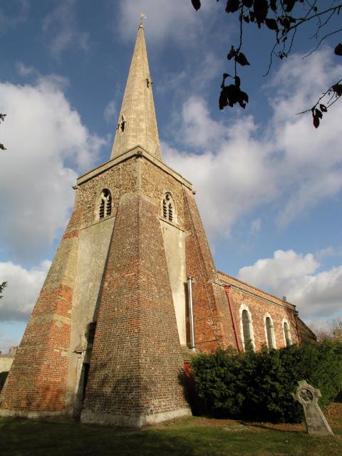
The village is known for its rural charm, with rolling green fields and quaint thatched-roof cottages dotting the landscape. Its rich history can be traced back to the Domesday Book of 1086 when it was mentioned as "Cunintone." The village has retained much of its historical character, evident in the architecture of its buildings, including the Grade II listed St. Mary's Church.

Conington benefits from its proximity to Cambridge, offering its residents easy access to the city's amenities and employment opportunities. The village is well-connected to the surrounding areas through a network of roads, making it an ideal location for commuters.

Nature enthusiasts will find plenty to explore in Conington, with numerous footpaths and bridleways crisscrossing the countryside. The nearby Conington Fen, a Site of Special Scientific Interest, provides a haven for wildlife and offers opportunities for birdwatching and nature walks.

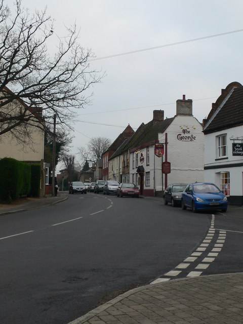
Local amenities in Conington are limited, with no shops or pubs within the village itself. However, nearby towns and villages provide essential services, including shops, schools, and healthcare facilities.

In summary, Conington is a picturesque and historic village in Cambridgeshire, offering a tranquil lifestyle and close proximity to the vibrant city of Cambridge. Its rural charm, rich history, and natural beauty make it an attractive place to call home.

If you have any feedback on the listing, please let us know in the comments section below.

Conington Images

Images are sourced within 2km of 52.278654/-0.060603 or Grid Reference TL3266. Thanks to Geograph Open Source API. All images are credited.

Conington Church
Conington Church
Sheep grazing at Conington View over sheep field towards Conington.
Sheep grazing at Conington
View over sheep field towards Conington.
St Mary's Church, Conington Clipped yews are a feature of this fenland church.
St Mary's Church, Conington
Clipped yews are a feature of this fenland church.
Martin Guy White memorial In St Mary's churchyard the inscription on the stone reads, "In loving memory of MARTIN GUY WHITE FEB 1944 - JULY 1999 POLAR MEDAL 1980 AND 1987.   I travelled the world with work that I love".
Martin Guy White memorial
In St Mary's churchyard the inscription on the stone reads, "In loving memory of MARTIN GUY WHITE FEB 1944 - JULY 1999 POLAR MEDAL 1980 AND 1987. I travelled the world with work that I love".
Road junction at Fenstanton
The old A.14 at Fenstanton This is part of the old Roman road between Cambridge and Huntingdon, now bypassed by the new section of the A.14
The old A.14 at Fenstanton
This is part of the old Roman road between Cambridge and Huntingdon, now bypassed by the new section of the A.14
The road towards Elsworth from Conington
Model Farm Model Farm to the south of Fenstanton, Cambridgeshgire.
Model Farm
Model Farm to the south of Fenstanton, Cambridgeshgire.
Conington duck pond Duck pond in the grounds of Conington Hall on the north-west edge of Conington, Cambridgeshire.
Conington duck pond
Duck pond in the grounds of Conington Hall on the north-west edge of Conington, Cambridgeshire.
Old plum orchards The trees on the other side of the deep drain are a remnant of what used to be an important fruit growing area.
Old plum orchards
The trees on the other side of the deep drain are a remnant of what used to be an important fruit growing area.
Field margin east of Conington With wildlife-friendly unmown grass left round the edge.
Field margin east of Conington
With wildlife-friendly unmown grass left round the edge.
Farm building at New Barns Farm Quite possibly a barn!
Farm building at New Barns Farm
Quite possibly a barn!
Main Farm Cottages Tucked away at the very end of the track behind the farm itself. Actually they look a bit grand for cottages!
Main Farm Cottages
Tucked away at the very end of the track behind the farm itself. Actually they look a bit grand for cottages!
Little Chef / Burger King Fenstanton
The White Swan Public House, Conington Off Conington Road
The White Swan Public House, Conington
Off Conington Road
The White Swan Public House sign, Conington On Conington Road
The White Swan Public House sign, Conington
On Conington Road
Conington Road, Conington Looking towards Hilton near The White Swan Public House
Conington Road, Conington
Looking towards Hilton near The White Swan Public House
Conington Road, Conington Looking towards the crossroads junction with High Street & Conington
Conington Road, Conington
Looking towards the crossroads junction with High Street & Conington
Show me another place!

Conington is located at Grid Ref: TL3266 (Lat: 52.278654, Lng: -0.060603)

Administrative County: Cambridgeshire

District: South Cambridgeshire

Police Authority: Cambridgeshire

What 3 Words

///hears.pleaser.players. Near Fenstanton, Cambridgeshire

Nearby Locations

Conington Conington

Related Wikis

Conington, South Cambridgeshire

Conington (Conington St Mary, or Coningtom-juxta-Cantab) is a small village in the South Cambridgeshire district of Cambridgeshire with about 50 houses...

Fenstanton

Fenstanton is a village and civil parish in Cambridgeshire, England, 2 miles (3 km) south of St Ives in Huntingdonshire, a non-metropolitan district of...

Fen Drayton

Fen Drayton is a small village between Cambridge and St. Ives in Cambridgeshire, England, and between the villages of Fenstanton and Swavesey. The village...

Elsworth

Elsworth is a village and civil parish in South Cambridgeshire, England, 9 miles northwest of Cambridge and 7 miles southeast of Huntingdon. At the 2011...

Boxworth

Boxworth is a village in South Cambridgeshire, situated about eight miles to the north-west of Cambridge. It falls under the Papworth Everard and Caxton...

Knapwell

Knapwell is a hamlet in Cambridgeshire situated about 10 miles (16 km) west of Cambridge. It is within the diocese of Ely. Its population was estimated...

Hilton Hall, Cambridgeshire

Hilton Hall is an early 17th-century English country house in the village of Hilton in Cambridgeshire. The hall is listed Grade II* on the National Heritage...

Hilton, Cambridgeshire

Hilton is a village and civil parish in Cambridgeshire, England. Hilton lies approximately 11 miles (18 km) north-west of Cambridge. Hilton is situated...

Nearby Amenities

Located within 500m of 52.278654,-0.060603
Post Box
Collection Times: Mo-Fr 16:15; Sa 09:30
Operator: Royal Mail
Post Box Type: lamp
Ref: CB23 272
Royal Cypher: EIIR
Royal Cypher Wikidata: Q33102113
Source: survey
Lat/Long: 52.2784825/-0.0633799
Bus Stop
White Swan
Naptan AtcoCode: 0500SCONI001
Naptan Bearing: S
Naptan BusStopType: CUS
Naptan CommonName: White Swan
Naptan Indicator: opp
Naptan Landmark: Conington Road
Naptan NaptanCode: cmbdwadm
Naptan ShortCommonName: White Swan
Naptan Street: Conington Road
Naptan Verified: no
Source: naptan_import
Lat/Long: 52.2822095/-0.0623424
Bus Stop
White Swan
Naptan AtcoCode: 0500SCONI002
Naptan Bearing: N
Naptan CommonName: White Swan
Naptan Indicator: near
Naptan Landmark: High Street
Naptan NaptanCode: cmbdwadp
Naptan ShortCommonName: White Swan
Naptan Street: High Street
Naptan Verified: no
Source: naptan_import
Lat/Long: 52.2821485/-0.0624624
Bus Stop
School Lane
Naptan AtcoCode: 0500SCONI003
Naptan Bearing: S
Naptan BusStopType: CUS
Naptan CommonName: School Lane
Naptan Indicator: opp
Naptan Landmark: School Lane
Naptan NaptanCode: cmbdwadt
Naptan ShortCommonName: School Lane
Naptan Street: Elsworth Road
Naptan Verified: no
Source: naptan_import
Lat/Long: 52.2788092/-0.0606143
Bus Stop
School Lane
Naptan AtcoCode: 0500SCONI004
Naptan Bearing: N
Naptan BusStopType: CUS
Naptan CommonName: School Lane
Naptan Indicator: near
Naptan Landmark: School Lane
Naptan NaptanCode: cmbdwadw
Naptan ShortCommonName: School Lane
Naptan Street: Elsworth Road
Naptan Verified: no
Source: naptan_import
Lat/Long: 52.2787839/-0.060718
Frequency: 50
Phases: 3
Power: pole
Transformer: distribution
Voltage Primary: 11000
Voltage Secondary: 400
Lat/Long: 52.2829163/-0.0605749
Power: pole
Lat/Long: 52.2795179/-0.0631043
Power: pole
Lat/Long: 52.279222/-0.0664067
Line Attachment: anchor
Location Transition: yes
Power: pole
Lat/Long: 52.2823545/-0.06201
Power: pole
Lat/Long: 52.2796738/-0.0614735
Power: pole
Lat/Long: 52.279385/-0.0647431
Power: pole
Lat/Long: 52.2790419/-0.0668704
Give Way
Lat/Long: 52.2786952/-0.0606663
The data included in this document is from www.openstreetmap.org. The data is made available under ODbL.

Have you been to Conington?

Leave your review of Conington below (or comments, questions and feedback).