Pimley Rough

Wood, Forest in Shropshire

England

Pimley Rough

Old Village Pump Found opposite the Holy Trinity Church in Uffington
Old Village Pump Credit: Rick Crowley

Pimley Rough is a picturesque woodland area located in Shropshire, England. Covering an area of approximately 50 hectares, it is often referred to as a forest due to its dense concentration of trees. The woodland is situated in close proximity to the small village of Pimley, giving it its name.

Pimley Rough is known for its diverse range of tree species, including oak, beech, ash, and birch. These trees create a lush and vibrant environment, providing habitat for a variety of wildlife. The forest floor is covered with a thick carpet of mosses, ferns, and wildflowers, adding to its natural beauty.

The woodland is crisscrossed by a network of footpaths, making it a popular destination for hikers and nature enthusiasts. These paths lead visitors through the heart of the forest, allowing them to immerse themselves in the tranquil surroundings and appreciate the abundance of flora and fauna.

Pimley Rough also boasts a small stream that meanders through the woodland, providing a source of water for the wildlife and adding to the overall charm of the area. In addition, there are several clearings within the forest, offering peaceful spots for visitors to stop and take in the scenic views.

Overall, Pimley Rough is a captivating woodland in Shropshire that offers visitors a chance to escape the hustle and bustle of everyday life and immerse themselves in the natural beauty of the forest.

If you have any feedback on the listing, please let us know in the comments section below.

Pimley Rough Images

Images are sourced within 2km of 52.725791/-2.7234647 or Grid Reference SJ5114. Thanks to Geograph Open Source API. All images are credited.

Old Village Pump Found opposite the Holy Trinity Church in Uffington
Old Village Pump
Found opposite the Holy Trinity Church in Uffington
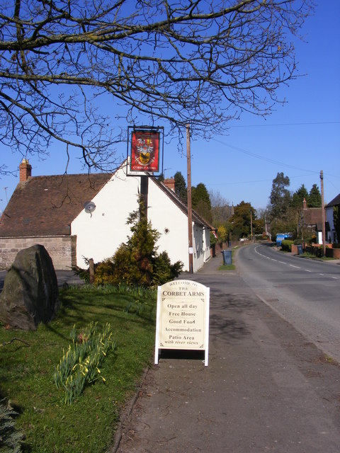
The Corbet Arms The Pub in Church Road Uffington.
The Corbet Arms
The Pub in Church Road Uffington.
Corbet Arms View The view from outside the Pub in Church Road Uffington.
Corbet Arms View
The view from outside the Pub in Church Road Uffington.
Canal Bridge View The view of the path to the disused Shrewsbury canal bridge near Uffington Village.
Canal Bridge View
The view of the path to the disused Shrewsbury canal bridge near Uffington Village.
Canal View South The view of the disused Shrewsbury canal bridge near Uffington Village.
Canal View South
The view of the disused Shrewsbury canal bridge near Uffington Village.
Canal View North The view from the bridge of the disused Shrewsbury canal near Uffington Village.
Canal View North
The view from the bridge of the disused Shrewsbury canal near Uffington Village.
Stream Stile The footpath passes over the stile and stream to the Sports Ground above.
Stream Stile
The footpath passes over the stile and stream to the Sports Ground above.
Sundorne Castle Gate The remains of a large estate now derelict,and used as a farm buildings.
Sundorne Castle Gate
The remains of a large estate now derelict,and used as a farm buildings.
Sundorne Castle View The remains of a large estate now derelict,and used as farm buildings.
Sundorne Castle View
The remains of a large estate now derelict,and used as farm buildings.
Sundorne Castle Stables The remains of the large Sundorne estate now derelict,and used as a farm buildings.
Sundorne Castle Stables
The remains of the large Sundorne estate now derelict,and used as a farm buildings.
Sundorne Castle Wall The side view of the remains of the large Sundorne estate now derelict,and used as a farm buildings.
Sundorne Castle Wall
The side view of the remains of the large Sundorne estate now derelict,and used as a farm buildings.
Sundorne Walled Garden The remains of the large Sundorne estate now derelict,and used as a farm buildings.
Sundorne Walled Garden
The remains of the large Sundorne estate now derelict,and used as a farm buildings.
Sunderton Cattle Grid The view near Sundorne Farm.
Sunderton Cattle Grid
The view near Sundorne Farm.
Church Road The road out of Uffington village towards the Newport Road and the A49.
Church Road
The road out of Uffington village towards the Newport Road and the A49.
Canal Cottage view The view of Church Road in Uffington near the disused Shrewsbury Canal.
Canal Cottage view
The view of Church Road in Uffington near the disused Shrewsbury Canal.
Uffington Scene The view in Uffington village with Holy Trinity in the centre.
Uffington Scene
The view in Uffington village with Holy Trinity in the centre.
Uffington Village Hall The view in the Shropshire village of the Hall and the Village Pump.
Uffington Village Hall
The view in the Shropshire village of the Hall and the Village Pump.
Holy Trinity Church The view of the Uffington Churchyard and noticeboard in the centre of the village.
Holy Trinity Church
The view of the Uffington Churchyard and noticeboard in the centre of the village.
Show me another place!

Pimley Rough is located at Grid Ref: SJ5114 (Lat: 52.725791, Lng: -2.7234647)

Unitary Authority: Shropshire

Police Authority: West Mercia

What 3 Words

///honest.life.rich. Near Shrewsbury, Shropshire

Nearby Locations

Pimley Rough

Related Wikis

Haughmond F.C.

Haughmond Football Club ( HOR-mənd) is a football club based in Shrewsbury, Shropshire, England. They are currently members of the Shropshire County League...

Sundorne

Sundorne is a suburb of the town of Shrewsbury, county town of Shropshire. It is located 2 km north of the town centre. The B5062 road begins at Heathgates...

Shrewsbury Academy

Shrewsbury Academy is an 11-16 mixed secondary school with academy status in Shrewsbury, Shropshire, England. It was established in September 2016 following...

Ditherington

Ditherington is a suburb of the town of Shrewsbury, the county town of Shropshire, England. It is the fourth most deprived ward in the Shropshire unitary...

Nearby Amenities

Located within 500m of 52.725791,-2.7234647
Mini Roundabout
Lat/Long: 52.7283724/-2.7219004
Sundorne
Is In: Shrewsbury, Shropshire, England, United Kingdom
Place: suburb
Wikidata: Q7639806
Lat/Long: 52.7296397/-2.7227207
Mini Roundabout
Direction: clockwise
Lat/Long: 52.7285226/-2.7177365
Traffic Signals
Traffic Signals: pedestrian_crossing
Lat/Long: 52.7285502/-2.7192598
Crossing
Crossing: zebra
Crossing Island: no
Tactile Paving: yes
Lat/Long: 52.7276667/-2.7190101
Barrier: stile
Lat/Long: 52.7236222/-2.7214528
Place Of Worship
Our Lady Of Pity, Harlescott
Denomination: catholic
Religion: christian
Lat/Long: 52.7292609/-2.7211863
Post Box
Check Date: 2021-06-04
Post Box Type: pillar
Ref: SY1 474
Royal Cypher: GR
Royal Cypher Wikidata: Q33102273
Lat/Long: 52.7279941/-2.7273066
Telephone
Booth: KX100
Covered: booth
Lat/Long: 52.7279194/-2.7272595
Crossing
Crossing: zebra
Crossing Island: no
Tactile Paving: yes
Lat/Long: 52.728402/-2.7193264
Bus Stop
Bus: yes
Public Transport: platform
Shelter: yes
Lat/Long: 52.7278919/-2.7255106
Bench
Lat/Long: 52.7264678/-2.7249687
Bench
Lat/Long: 52.7258188/-2.7231449
Barrier: stile
Lat/Long: 52.7266604/-2.7256621
Crossing
Crossing: unmarked
Crossing Island: yes
Crossing Markings: no
Kerb: flush
Tactile Paving: yes
Lat/Long: 52.7273534/-2.7288678
Generator Method: photovoltaic
Generator Output Electricity: yes
Generator Source: solar
Generator Type: solar_photovoltaic_panel
Location: roof
Power: generator
Lat/Long: 52.7263043/-2.729888
Generator Method: photovoltaic
Generator Output Electricity: yes
Generator Source: solar
Generator Type: solar_photovoltaic_panel
Location: roof
Power: generator
Lat/Long: 52.7269963/-2.7298129
Generator Method: photovoltaic
Generator Output Electricity: yes
Generator Source: solar
Generator Type: solar_photovoltaic_panel
Location: roof
Power: generator
Lat/Long: 52.7269232/-2.727989
Generator Method: photovoltaic
Generator Output Electricity: yes
Generator Source: solar
Generator Type: solar_photovoltaic_panel
Location: roof
Power: generator
Lat/Long: 52.7284257/-2.7239496
Generator Method: photovoltaic
Generator Output Electricity: yes
Generator Source: solar
Generator Type: solar_photovoltaic_panel
Location: roof
Power: generator
Lat/Long: 52.7295075/-2.722477
Generator Method: photovoltaic
Generator Output Electricity: yes
Generator Source: solar
Generator Type: solar_photovoltaic_panel
Location: roof
Power: generator
Lat/Long: 52.729886/-2.7220264
Access: yes
Leisure: playground
Lat/Long: 52.7261474/-2.7166965
Bicycle Parking
Bicycle Parking: stands
Covered: yes
Lat/Long: 52.7276136/-2.7193458
Entrance: main
Lat/Long: 52.7276026/-2.7190052
Entrance: main
Lat/Long: 52.7280975/-2.7201153
Bench
Material: wood
Seats: 2
Lat/Long: 52.7278774/-2.7255673
Barrier: bollard
Bicycle: designated
Foot: designated
Horse: yes
Motor Vehicle: no
Lat/Long: 52.7286716/-2.7191948
Barrier: bollard
Bicycle: designated
Foot: designated
Horse: yes
Motor Vehicle: no
Lat/Long: 52.7286393/-2.7201884
Traffic Calming: bump
Lat/Long: 52.7299599/-2.7237837
Traffic Calming: bump
Lat/Long: 52.730044/-2.7237967
Give Way
Direction: backward
Lat/Long: 52.7296278/-2.7237345
Give Way
Direction: backward
Lat/Long: 52.7295649/-2.7237262
Crossing
Crossing: unmarked
Crossing Island: yes
Crossing Markings: no
Kerb: flush
Tactile Paving: yes
Lat/Long: 52.7277736/-2.7264395
Bus Stop
Bus: yes
Naptan AtcoCode: 3500B107304
Naptan NaptanCode: shrajtaj
Public Transport: platform
Shelter: no
Lat/Long: 52.7277252/-2.7271413
Bus Stop
Bus: yes
Public Transport: platform
Lat/Long: 52.7283358/-2.7229261
Crossing
Button Operated: yes
Crossing: traffic_signals
Crossing Island: no
Crossing Ref: pelican
Kerb: flush
Tactile Paving: yes
Lat/Long: 52.7283391/-2.7222019
Crossing
Crossing: unmarked
Crossing Island: no
Crossing Markings: no
Kerb: flush
Tactile Paving: yes
Lat/Long: 52.7284913/-2.7222367
Clinic
Shropshire and Mid Wales Fertility Centre
Addr Postcode: SY1 4RQ
Healthcare: clinic
Lat/Long: 52.7279514/-2.7215878
Bicycle Parking
Bicycle Parking: shed
Lat/Long: 52.7282602/-2.721999
Bus Stop
Bus: yes
Public Transport: platform
Shelter: yes
Lat/Long: 52.7295196/-2.721456
Crossing
Crossing: uncontrolled
Crossing Markings: zebra
Lat/Long: 52.727445/-2.7214293
Crossing
Crossing: uncontrolled
Crossing Markings: zebra
Lat/Long: 52.7281761/-2.7219129
Crossing
Crossing: uncontrolled
Crossing Markings: zebra
Lat/Long: 52.7282083/-2.7216994
Barrier: kerb
Kerb: flush
Tactile Paving: yes
Lat/Long: 52.7283146/-2.7221928
Barrier: kerb
Kerb: flush
Tactile Paving: yes
Lat/Long: 52.7283879/-2.7222131
Crossing
Crossing: unmarked
Crossing Island: no
Crossing Markings: no
Tactile Paving: yes
Lat/Long: 52.7282854/-2.7218631
Barrier: kerb
Kerb: flush
Tactile Paving: yes
Lat/Long: 52.7282821/-2.7219169
Barrier: yes
Lat/Long: 52.7282887/-2.717685
Crossing
Crossing: unmarked
Crossing Island: yes
Crossing Markings: no
Tactile Paving: yes
Lat/Long: 52.7284016/-2.717697
Give Way
Lat/Long: 52.7281996/-2.7177069
Traffic Calming: bump
Lat/Long: 52.7280446/-2.7176435
Crossing
Crossing: unmarked
Crossing Island: no
Crossing Markings: no
Tactile Paving: yes
Lat/Long: 52.7281553/-2.7175308
Barrier: height_restrictor
Lat/Long: 52.7279951/-2.7176409
Robsons Stores
Addr City: Shrewsbury
Addr Country: GB
Addr Housenumber: 4
Addr Postcode: SY1 4JP
Addr Street: Sundorne Avenue
Fhrs Authority: Shropshire
Fhrs Id: 104670
Fhrs Local Authority Id: 35760
Shop: convenience
Lat/Long: 52.7281171/-2.7270448
Fast Food
Wok King
Addr City: Shrewsbury
Addr Country: GB
Addr Housenumber: 5
Addr Postcode: SY1 4JW
Addr Street: Sundorne Avenue
Fhrs Authority: Shropshire
Fhrs Id: 698830
Fhrs Local Authority Id: 14/00110/COMM
Lat/Long: 52.7280473/-2.7274686
Beauty From Within
Shop: beauty
Lat/Long: 52.7279758/-2.7274632
Tax Assist Accountants
Office: accountant
Lat/Long: 52.7279206/-2.7274498
The data included in this document is from www.openstreetmap.org. The data is made available under ODbL.

Have you been to Pimley Rough?

Leave your review of Pimley Rough below (or comments, questions and feedback).