Nan Holes Wood

Wood, Forest in Lancashire South Ribble

England

Nan Holes Wood

Liverpool Road at Hutton boundary
Liverpool Road at Hutton boundary Credit: Colin Pyle

Nan Holes Wood is a picturesque woodland area located in Lancashire, England. Situated near the village of Chipping, the wood is nestled within the scenic Forest of Bowland, a designated Area of Outstanding Natural Beauty.

Covering an area of approximately 50 acres, Nan Holes Wood is predominantly made up of mixed broadleaf trees, including oak, birch, and ash. The dense canopy provides a haven for a variety of wildlife, including birds, squirrels, and deer, making it a popular spot for nature enthusiasts and birdwatchers.

The wood is crisscrossed by a network of well-maintained footpaths, allowing visitors to explore and immerse themselves in the tranquil surroundings. These paths wind through the ancient woodland, leading to hidden glades and peaceful ponds, adding to the charm and beauty of the area.

In addition to its natural beauty, Nan Holes Wood also has historical significance. It is believed to have been part of the hunting grounds of the Lords of Bowland, who would have used the wood for hunting game in centuries past.

Today, Nan Holes Wood is managed by the Forestry Commission, ensuring the preservation and protection of this precious natural resource. The wood provides a peaceful escape from the hustle and bustle of modern life, offering a serene and tranquil environment for visitors to enjoy. Whether it's a leisurely stroll, birdwatching, or simply taking in the beauty of nature, Nan Holes Wood is a hidden gem in the heart of Lancashire.

If you have any feedback on the listing, please let us know in the comments section below.

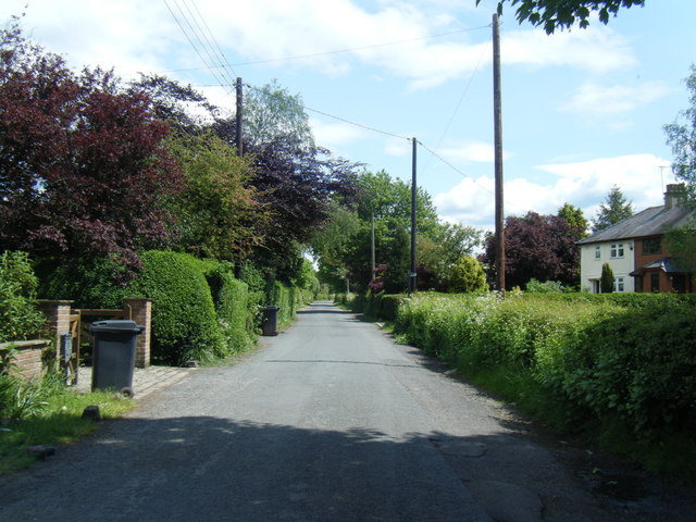
Nan Holes Wood Images

Images are sourced within 2km of 53.733681/-2.7517446 or Grid Reference SD5026. Thanks to Geograph Open Source API. All images are credited.

Liverpool Road at Hutton boundary
Liverpool Road, Hutton
Skip Lane/Ratten Lane junction
Ratten Lane near Sherdley Farm
Marsh Farm from Howick Cross Lane
A59 Longton by-pass
A59 Longton by-pass
The  footpath  is  the  other  side The footpath to Longton is the other side of the ditch, it comes in from the right then straight ahead through the gate up to Longton. The field drainage is being updated so a slight detour, taken from the grounds of Willow Cottage our B & B for the night. Longton is the start of the Ribble Way
The footpath is the other side
The footpath to Longton is the other side of the ditch, it comes in from the right then straight ahead through the gate up to Longton. The field drainage is being updated so a slight detour, taken from the grounds of Willow Cottage our B & B for the night. Longton is the start of the Ribble Way
Willow  Cottage  Longton Our very nice B & B for the night when we started to walk the Ribble Way
Willow Cottage Longton
Our very nice B & B for the night when we started to walk the Ribble Way
Houses on Chapel Lane, New Longton
Field entrance off Brownhill Lane, Longton
Brownhill Lane, Longton Looking south east on the flat.
Brownhill Lane, Longton
Looking south east on the flat.
Grazing off Drumacre Lane East
Old Boundary Marker by Liverpool Road, Hutton Parish Boundary Marker by the UC road (was A59), in parish of Hutton (South Ribble District), Liverpool Road, after second sign for Hutton.

Inscription reads:-
: HUTTON : : LONGTON :
Carved bench mark on top. 

Surveyed

Milestone Society National ID: LA_HUTLON01pb
Old Boundary Marker by Liverpool Road, Hutton
Parish Boundary Marker by the UC road (was A59), in parish of Hutton (South Ribble District), Liverpool Road, after second sign for Hutton. Inscription reads:- : HUTTON : : LONGTON : Carved bench mark on top. Surveyed Milestone Society National ID: LA_HUTLON01pb
Footpath Near Hutton This path connects with the Ribble Way a little further to the north.
Footpath Near Hutton
This path connects with the Ribble Way a little further to the north.
The Anchor Inn, Hutton Large public house on Liverpool Road.
The Anchor Inn, Hutton
Large public house on Liverpool Road.
Hutton, Liverpool Road
Liverpool Road, between Longton and Hutton
Road & public footpath to the Ribble
Show me another place!

Nan Holes Wood is located at Grid Ref: SD5026 (Lat: 53.733681, Lng: -2.7517446)

Administrative County: Lancashire

District: South Ribble

Police Authority: Lancashire

What 3 Words

///ranks.chins.gear. Near Preston, Lancashire

Related Wikis

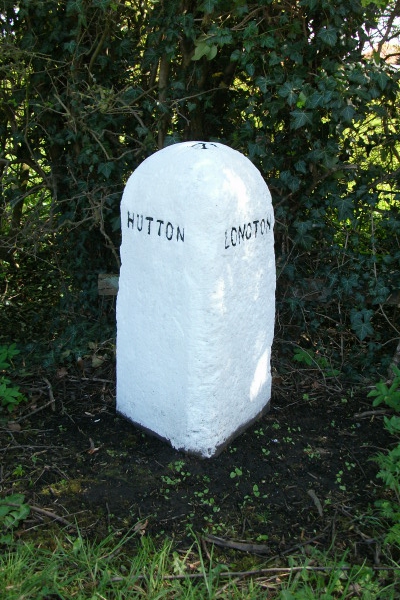
New Longton and Hutton railway station

New Longton and Hutton station was a railway station on the West Lancashire Railway in England. It was over a mile from each of the villages of Hutton...

Hutton, Lancashire

Hutton is a village and civil parish in Lancashire, England. It is located 3 miles (4.8 km) south west of Preston, in the South Ribble borough and parliamentary...

New Longton

New Longton is a village located 4 miles (6 km) south west of Preston, in the district of South Ribble, in the county of Lancashire, North West England...

All Hallows Catholic High School

All Hallows Catholic High School is a coeducational secondary school located in Penwortham in the English county of Lancashire.Established in 1975, it...

Nearby Amenities

Located within 500m of 53.733681,-2.7517446
Note: FIXME
Lat/Long: 53.7328796/-2.7504097
Power: tower
Lat/Long: 53.7355677/-2.7465498
Post Box
Ref: PR4 15
Lat/Long: 53.7333494/-2.7493877
Bench
Backrest: yes
Lat/Long: 53.7366931/-2.7571885
Crossing
Crossing: unmarked
Lat/Long: 53.7346976/-2.7589914
Give Way
Direction: backward
Lat/Long: 53.7375415/-2.7545237
Barrier: kissing_gate
Foot: designated
Lat/Long: 53.7316448/-2.7515971
Barrier: yes
Lat/Long: 53.7362598/-2.7507338
Barrier: yes
Lat/Long: 53.7364079/-2.7491952
Barrier: yes
Lat/Long: 53.7356825/-2.7486997
Bus Stop
Bus: yes
Naptan AtcoCode: 250014698
Naptan Bearing: SE
Naptan CommonName: Agricultural College
Naptan Indicator: by
Naptan NaptanCode: lanamwmw
Public Transport: platform
Lat/Long: 53.7359585/-2.7500115
The data included in this document is from www.openstreetmap.org. The data is made available under ODbL.

Have you been to Nan Holes Wood?

Leave your review of Nan Holes Wood below (or comments, questions and feedback).