Deepdale Wood

Wood, Forest in Westmorland South Lakeland

England

Deepdale Wood

Lakeland Wildlife Oasis A scary, eye-catching sight on the A6.
Lakeland Wildlife Oasis Credit: Mary and Angus Hogg

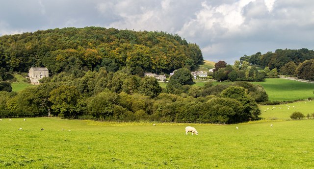
Deepdale Wood is a picturesque forest located in the county of Westmorland, England. Covering an area of approximately 500 acres, it is a haven of natural beauty and tranquility. Situated near the village of Deepdale, the wood is easily accessible and attracts visitors from both the local community and those further afield.

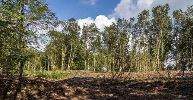
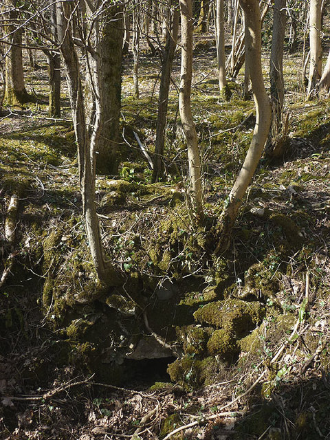
The wood is predominantly made up of deciduous trees, such as oak, beech, and ash, creating a diverse and vibrant ecosystem. The dense foliage provides a rich habitat for a wide variety of flora and fauna. Visitors can expect to encounter an array of woodland plants, including bluebells, primroses, and wild garlic, which carpet the forest floor during the spring months.

Deepdale Wood is also home to a range of wildlife species. Birdwatchers will delight in the sight of numerous species, including woodpeckers, nuthatches, and tawny owls. The forest's peaceful atmosphere makes it an ideal location for spotting elusive mammals such as deer, badgers, and foxes.

For outdoor enthusiasts, the wood offers a network of walking trails that meander through its enchanting scenery. These well-maintained paths cater to all abilities, allowing visitors to explore the wood at their own pace. There are also designated picnic areas where visitors can relax and enjoy a meal amidst the natural surroundings.

Deepdale Wood is not only a sanctuary for nature lovers but also serves as an important educational resource. The wood is frequently used by local schools and environmental groups to teach children about the importance of conservation and the delicate balance of ecosystems.

In summary, Deepdale Wood is a captivating forest in Westmorland that offers a delightful escape into nature. With its diverse flora and fauna, well-marked trails, and educational opportunities, it is a place that both visitors and locals can appreciate and enjoy.

If you have any feedback on the listing, please let us know in the comments section below.

Deepdale Wood Images

Images are sourced within 2km of 54.201508/-2.7722327 or Grid Reference SD4978. Thanks to Geograph Open Source API. All images are credited.

Lakeland Wildlife Oasis A scary, eye-catching sight on the A6.
Lakeland Wildlife Oasis
A scary, eye-catching sight on the A6.
On the A6 near Beetham Looking towards the north on a bright late-April morning.
On the A6 near Beetham
Looking towards the north on a bright late-April morning.
Farmland view Lots of grassland and well-tended fields on Burton Moss.
Farmland view
Lots of grassland and well-tended fields on Burton Moss.
Moss Lane view Looking towards the A6, in the next square, on a fine April morning.
Moss Lane view
Looking towards the A6, in the next square, on a fine April morning.
Farm sheds near Beetham These sheds lie to the south of the River Bela.
Farm sheds near Beetham
These sheds lie to the south of the River Bela.
On the A6 The M6 takes most of the traffic away from the old trunk road which makes it less stressful to use.
On the A6
The M6 takes most of the traffic away from the old trunk road which makes it less stressful to use.
Crossroads at Hale This is where Pye’s Bridge Lane joins the A6 near Beetham.
Crossroads at Hale
This is where Pye’s Bridge Lane joins the A6 near Beetham.
Pye’s Bridge Lane Viewed in late April with the roadside flowers showing well.
Pye’s Bridge Lane
Viewed in late April with the roadside flowers showing well.
Pye’s Bridge The bridge crosses Holme Beck.
Pye’s Bridge
The bridge crosses Holme Beck.
A6 towards Milnthorpe
A6 near Hale
A6 near Hale
A6 The junction of Paradise Lane with the A6.
A6
The junction of Paradise Lane with the A6.
Haverbrack
Haverbrack
Wray Cottages Visible after the felling of trees.
Wray Cottages
Visible after the felling of trees.
Spring lamb, Spring snow A lamb reclines in warm Spring sunshine whilst overnight snow has briefly whitened the fells of the Yorkshire Dales. Curiously, the higher Lakeland fells were unaffected, possibly due to their closer proximity to the sea.
Spring lamb, Spring snow
A lamb reclines in warm Spring sunshine whilst overnight snow has briefly whitened the fells of the Yorkshire Dales. Curiously, the higher Lakeland fells were unaffected, possibly due to their closer proximity to the sea.
The Deer Shed, Dallam Park The fallow deer that inhabit The Park <a href="https://www.geograph.org.uk/photo/4585838">SD4980 : Fallow deer in The Park, Dallam Tower</a> were nowhere to be seen today.
The Deer Shed, Dallam Park
The fallow deer that inhabit The Park SD4980 : Fallow deer in The Park, Dallam Tower were nowhere to be seen today.
Relaxing in The Park A recently arrived resident of The Park gets some sleep in the warm Spring sunshine. It's obviously hard work running and jumping about all morning.
Relaxing in The Park
A recently arrived resident of The Park gets some sleep in the warm Spring sunshine. It's obviously hard work running and jumping about all morning.
Possible ruined lime kiln, woods west of Haverbrack At first I thought that this hole just west of the footpath might be a natural cave or mine working. A peek inside revealed rough masonry which I took to be the remnants of an old kiln.
Possible ruined lime kiln, woods west of Haverbrack
At first I thought that this hole just west of the footpath might be a natural cave or mine working. A peek inside revealed rough masonry which I took to be the remnants of an old kiln.
Show me another place!

Deepdale Wood is located at Grid Ref: SD4978 (Lat: 54.201508, Lng: -2.7722327)

Administrative County: Cumbria

District: South Lakeland

Police Authority: Cumbria

What 3 Words

///teardrop.defeated.weeknight. Near Milnthorpe, Cumbria

Related Wikis

Slack Head

Slack Head, sometimes written Slackhead, is a hamlet near Beetham, South Lakeland, Cumbria, England. It is in Beetham civil parish. It is a purely residential...

Beetham

Beetham is a village and civil parish in the South Lakeland district, in Cumbria, England, situated on the border with Lancashire, 6 miles (10 km) north...

Storth

Storth is a village near Arnside in Cumbria, England, situated near the border with Lancashire. It is in the historic county of Westmorland. The village...

Ashton House, Cumbria

Ashton House is a large country house in Beetham in Cumbria. It is a Grade II* listed building. == History == The house was built in 1678 probably for...

Hale, Cumbria

Hale is a hamlet near Beetham in the south of Cumbria, England. It lies on the A6 road, between Carnforth to the south and Milnthorpe to the north. It...

St Michael's Church, Beetham

St Michael's Church is in the village of Beetham, Cumbria, England. It is an active Anglican parish church in the deanery of Kendal, the archdeaconry of...

Heron Corn Mill

The Heron Corn Mill is a working 18th-century water mill on the River Bela at Beetham, Cumbria, England. The mill and its mill race are Grade II* listed...

Lakeland Wildlife Oasis

The Lakeland Wildlife Oasis is a small zoological collection near the town of Milnthorpe, Cumbria, England, with a science and evolution theme. Since April...

Nearby Amenities

Located within 500m of 54.201508,-2.7722327
Post Box
Collection Times: Mo-Fr 15:45; Sa 10:30
Drive Through: no
Post Box Type: lamp
Ref: LA7 248
Lat/Long: 54.2024309/-2.7791642
Barrier: stile
Lat/Long: 54.2040212/-2.7705333
Barrier: stile
Lat/Long: 54.2032862/-2.7691295
Give Way
Direction: forward
Lat/Long: 54.2023962/-2.7793466
Give Way
Direction: forward
Lat/Long: 54.203297/-2.7784044
Barrier: stile
Lat/Long: 54.2002047/-2.766254
Power: pole
Lat/Long: 54.2039553/-2.7677041
Power: pole
Lat/Long: 54.2043613/-2.7694292
Power: pole
Lat/Long: 54.2047981/-2.771277
Power: pole
Lat/Long: 54.2052883/-2.7733877
Deepdale Wood
Natural: wood
Lat/Long: 54.2009824/-2.7714175
Information: guidepost
Tourism: information
Lat/Long: 54.2009959/-2.7766897
Information: guidepost
Tourism: information
Lat/Long: 54.2040184/-2.7705774
Information: route_marker
Tourism: information
Lat/Long: 54.2032861/-2.7690891
Information: route_marker
Tourism: information
Lat/Long: 54.2025586/-2.7682607
Information: route_marker
Tourism: information
Lat/Long: 54.2017992/-2.76734
Information: guidepost
Tourism: information
Lat/Long: 54.2010116/-2.7663146
Information: board
Tourism: information
Lat/Long: 54.2007978/-2.7663409
Information: guidepost
Tourism: information
Lat/Long: 54.200223/-2.7662897
Information: route_marker
Tourism: information
Lat/Long: 54.1999465/-2.7668082
Information: route_marker
Tourism: information
Lat/Long: 54.1997139/-2.7664845
The data included in this document is from www.openstreetmap.org. The data is made available under ODbL.

Have you been to Deepdale Wood?

Leave your review of Deepdale Wood below (or comments, questions and feedback).