Harmer Moss Plantation

Wood, Forest in Shropshire

England

Harmer Moss Plantation

Bridleway and farm track near Merrington Green A long but seemingly much used track and bridleway that leads from Merrington northwards to Myddle.
Bridleway and farm track near Merrington Green Credit: Jeremy Bolwell

Harmer Moss Plantation is a woodland area located in the picturesque county of Shropshire, England. Situated near the town of Ludlow, the plantation covers an expansive area, boasting a mix of dense forest and open spaces. It is a popular destination for nature enthusiasts, hikers, and birdwatchers.

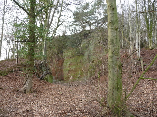
The woodland at Harmer Moss Plantation is predominantly composed of native tree species such as oak, beech, and birch. These majestic trees provide a dense canopy, creating a haven for a variety of wildlife. The forest floor is covered with a rich carpet of moss, adding to the enchanting atmosphere of the plantation.

The diverse ecosystem of Harmer Moss Plantation supports a wide range of flora and fauna. Bird species such as woodpeckers, owls, and warblers can be spotted among the trees, while small mammals like foxes, badgers, and squirrels find shelter in the undergrowth. The plantation is also home to various insects, including butterflies and beetles, which thrive in the abundance of wildflowers and ferns.

Visitors can explore the woodland through a network of well-maintained trails, which offer opportunities for leisurely walks or more challenging hikes. The plantation is also equipped with picnic areas, allowing visitors to rest and enjoy the tranquil surroundings.

Harmer Moss Plantation is a haven of natural beauty in Shropshire. Its mix of dense forest, open spaces, and diverse wildlife make it a must-visit destination for nature lovers and those seeking a peaceful escape into the heart of nature.

If you have any feedback on the listing, please let us know in the comments section below.

Harmer Moss Plantation Images

Images are sourced within 2km of 52.793282/-2.7655745 or Grid Reference SJ4822. Thanks to Geograph Open Source API. All images are credited.

Bridleway and farm track near Merrington Green A long but seemingly much used track and bridleway that leads from Merrington northwards to Myddle.
Bridleway and farm track near Merrington Green
A long but seemingly much used track and bridleway that leads from Merrington northwards to Myddle.
Old quarry face near Webscott One of several old quarry faces in this immediate area.
Old quarry face near Webscott
One of several old quarry faces in this immediate area.
Woodland near Webscott, Shropshire A steep valley is clothed with pine trees.
Woodland near Webscott, Shropshire
A steep valley is clothed with pine trees.
Mast on the hilltop above Webscott The stile is now redundant but the woodland edge gives a view to the mast on the crown of this little hillock.
Mast on the hilltop above Webscott
The stile is now redundant but the woodland edge gives a view to the mast on the crown of this little hillock.
The Nest, Webscott This lovely individual residence is called 'The Nest' and seems to have always been someone's pride and joy. It's built into or abutting the rockface behind it and its elevated position gives it pleasant south facing views. It seems to have been extended but maybe started out as a quarry manager's cottage? Who knows?
The Nest, Webscott
This lovely individual residence is called 'The Nest' and seems to have always been someone's pride and joy. It's built into or abutting the rockface behind it and its elevated position gives it pleasant south facing views. It seems to have been extended but maybe started out as a quarry manager's cottage? Who knows?
Rock cut path below 'The Nest', Webscott This access path has been quarried from the solid sandstone. Nice.
Rock cut path below 'The Nest', Webscott
This access path has been quarried from the solid sandstone. Nice.
Old Primitive Methodist chapel in Webscott A simple but beautiful chapel building. Dated 1842.
Old Primitive Methodist chapel in Webscott
A simple but beautiful chapel building. Dated 1842.
Part of Merrington Lane between Webscott and Merrington A long, direct but slightly winding lane running between the two old villages.
Part of Merrington Lane between Webscott and Merrington
A long, direct but slightly winding lane running between the two old villages.
Farm building at Merrington Lane Farm, near Merrington I wonder if this building is still used as intended? I don't recall seeing another single structure like this one.
Farm building at Merrington Lane Farm, near Merrington
I wonder if this building is still used as intended? I don't recall seeing another single structure like this one.
The old village pump, Merrington The pump handle has long since disappeared but the pump still stands here on a junction.
The old village pump, Merrington
The pump handle has long since disappeared but the pump still stands here on a junction.
Stone plaque at Merrington village pump Worded from an era very different to the present era it reads;
                  'To the memory of
         Robert Aglionby Slaney and Elizabth Slaney
                      his wife
            Formerly Elizabeth Muckleton
          heiress of Walford and Merrington
      The first of their many efforts to benefit 
      their neighbours was to cause this deep well 
                     to be sunk.
           They rest from their labours and
             their works do follow them.
       This pump was placed to complete the work
                         by
   Thomas Campbell Eyton and Elizabeth Frances Eyton
                     June 1864'.
A time when even access to clean water was of vital importance to the locals. Something that present generations take absolutely for granted.
Stone plaque at Merrington village pump
Worded from an era very different to the present era it reads; 'To the memory of Robert Aglionby Slaney and Elizabth Slaney his wife Formerly Elizabeth Muckleton heiress of Walford and Merrington The first of their many efforts to benefit their neighbours was to cause this deep well to be sunk. They rest from their labours and their works do follow them. This pump was placed to complete the work by Thomas Campbell Eyton and Elizabeth Frances Eyton June 1864'. A time when even access to clean water was of vital importance to the locals. Something that present generations take absolutely for granted.
Wooden viewing stage over a pool in Merrington I think it may be for fishing or just viewing the pool and its wildlife.
Wooden viewing stage over a pool in Merrington
I think it may be for fishing or just viewing the pool and its wildlife.
Roadside strip, Shotton Lane A narrow holly rich woodland.
Roadside strip, Shotton Lane
A narrow holly rich woodland.
Shotton Lane South of Harmer Hill.
Shotton Lane
South of Harmer Hill.
Wall, Shotton Hall Dressed Permian sandstone block.
Wall, Shotton Hall
Dressed Permian sandstone block.
Alderton A short road cutting out a crossroads.
Alderton
A short road cutting out a crossroads.
Newton Meadows Cottages from B5476
B5476 approaching Harmer Hill
Show me another place!

Harmer Moss Plantation is located at Grid Ref: SJ4822 (Lat: 52.793282, Lng: -2.7655745)

Unitary Authority: Shropshire

Police Authority: West Mercia

What 3 Words

///riverside.decency.sunbeam. Near Clive, Shropshire

Nearby Locations

Harmer Moss Plantation

Related Wikis

Harmer Hill

Harmer Hill is a village in Shropshire, England located on the A528 south of Wem and north of Shrewsbury. The name Harmer comes from the two words "hare...

Merrington, Shropshire

Merrington is a small village in Shropshire, England. It is situated to the north of the larger village of Bomere Heath and lies in the parish of Pimhill...

Alderton, Shropshire

Alderton is a village in Shropshire, England. == See also == Listed buildings in Myddle and Broughton == External links == Media related to Alderton,...

Myddle

Myddle—also formerly known as Mydle, Middle, Midle, M'dle, Meadley and Medle—is a small village and former civil parish, now in the parish of Myddle, Broughton...

Nearby Amenities

Located within 500m of 52.793282,-2.7655745
Harmer Hill
Place: village
Wikidata: Q3812614
Lat/Long: 52.7957396/-2.7597925
The data included in this document is from www.openstreetmap.org. The data is made available under ODbL.

Have you been to Harmer Moss Plantation?

Leave your review of Harmer Moss Plantation below (or comments, questions and feedback).