Brownheath Moss
Wood, Forest in Shropshire
England
Brownheath Moss

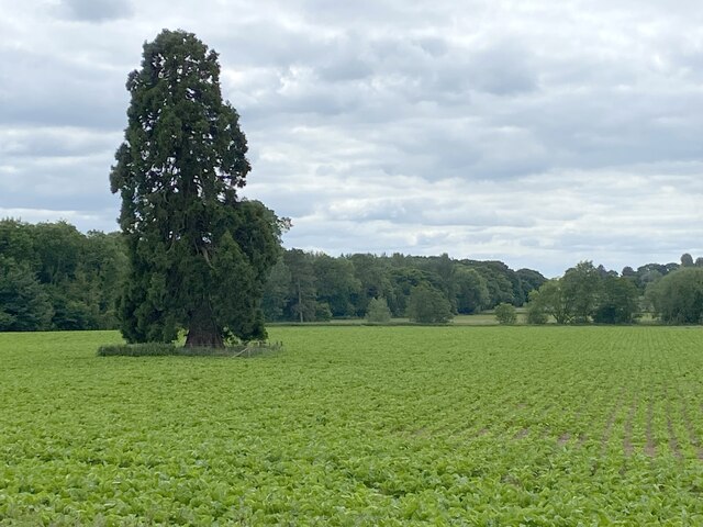
Brownheath Moss is a beautiful woodland located in Shropshire, England. It is known for its dense forest cover and abundant wildlife, making it a popular destination for nature lovers and outdoor enthusiasts. The moss is situated in the northern part of Shropshire, near the village of Stiperstones and the larger town of Bishop's Castle.
Spanning over an area of approximately 100 acres, Brownheath Moss is characterized by its rich biodiversity. The forest is primarily composed of deciduous trees such as oak, beech, and birch, which create a vibrant canopy overhead. The forest floor is covered in a thick layer of moss and ferns, adding to the area's enchanting atmosphere.
The moss is home to a wide variety of wildlife species. Red squirrels, badgers, and deer can often be spotted roaming through the forest, while a diverse array of birds, including woodpeckers and owls, can be heard singing in the treetops. Additionally, the moss is known for its thriving population of butterflies and insects, adding to the ecological diversity of the area.
To preserve the natural beauty of Brownheath Moss, the forest is managed by local authorities and conservation organizations. This ensures that the woodland remains a sanctuary for both flora and fauna, while also providing opportunities for visitors to explore and appreciate its natural wonders. Several walking trails and paths wind through the moss, allowing visitors to immerse themselves in the peaceful ambiance of this ancient woodland.
Overall, Brownheath Moss is a captivating woodland in Shropshire, offering a serene escape into nature and a chance to witness the wonders of the local ecosystem.
If you have any feedback on the listing, please let us know in the comments section below.
Brownheath Moss Images
Images are sourced within 2km of 52.866689/-2.8039447 or Grid Reference SJ4530. Thanks to Geograph Open Source API. All images are credited.


Brownheath Moss is located at Grid Ref: SJ4530 (Lat: 52.866689, Lng: -2.8039447)
Unitary Authority: Shropshire
Police Authority: West Mercia
What 3 Words
///secretly.flexed.outbound. Near Petton, Shropshire
Related Wikis
English Frankton
English Frankton, formerly known simply as Frankton, is a small village in Shropshire, England. It lies between the villages of Cockshutt and Loppington...

Loppington
Loppington is a village and parish in Shropshire, England, situated a few miles west of Wem. The population of the parish (2001) is 576 and there are 206...

Cockshutt, Shropshire
Cockshutt is a village and civil parish in Shropshire, England == Cockshutt-cum-Petton == Cockshutt-cum-Petton is the name of the combined parish council...

Colemere Countryside Site
Colemere Countryside Site is a countryside heritage site. Due to its important conservation status it has two key designations being a Site of Special...

Petton, Shropshire
Petton is a small village and civil parish in Shropshire, England. It was mentioned in Domesday as "Peetone", a name probably derived from Old English...
Welshampton and Lyneal
Welshampton and Lyneal is a civil parish in Shropshire, England. The population of the civil parish at the 2011 census was 852.The current parish is the...
Burlton
Burlton is a hamlet in Shropshire, England. == External links == Media related to Burlton at Wikimedia Commons

Sleap Airfield
Sleap Airfield (pronounced "Slape") (IATA: n/a, ICAO: EGCV) is located 10 NM (19 km; 12 mi) north of Shrewsbury, Shropshire, England. Sleap Aerodrome has...
Nearby Amenities
Located within 500m of 52.866689,-2.8039447Have you been to Brownheath Moss?
Leave your review of Brownheath Moss below (or comments, questions and feedback).