Applecross

Settlement in Ross-shire

Scotland

Applecross

Coast road north of Applecross
Coast road north of Applecross Credit: Alpin Stewart

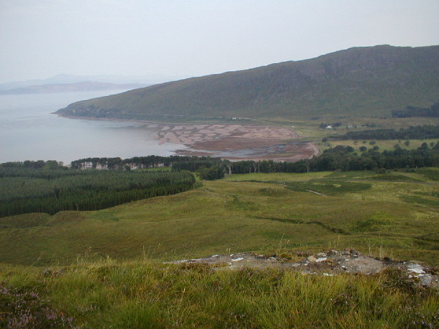
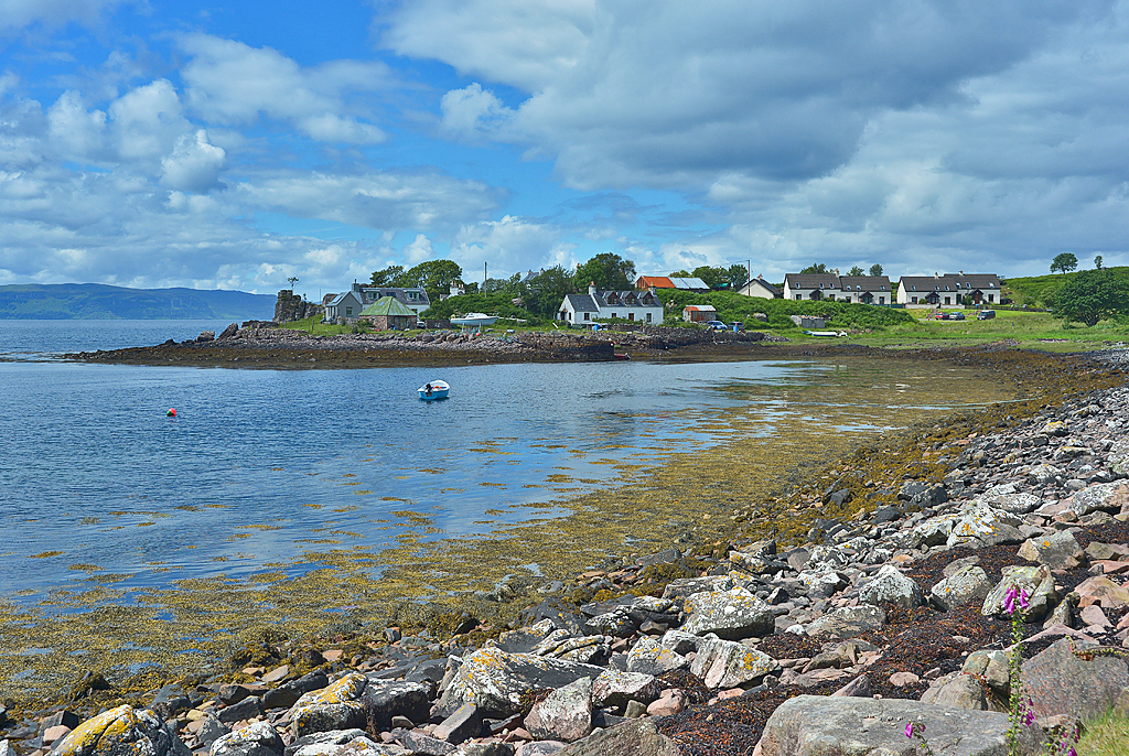
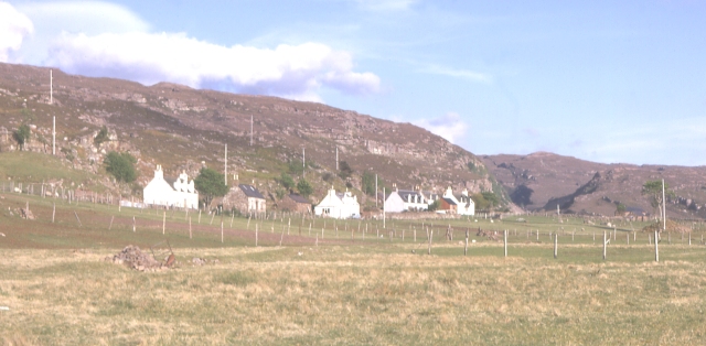
Applecross is a small village located in the county of Ross-shire, in the Highlands region of Scotland. Situated on the Applecross Peninsula, it is nestled between the breathtaking scenery of the Applecross Bay to the east and the imposing Applecross Mountains to the south. The village is accessible via the winding and challenging Bealach na Bà road, which offers stunning panoramic views for visitors as they make their way to this remote and picturesque destination.

With a population of just over 200, Applecross is a close-knit community that has retained its traditional charm throughout the years. The village is known for its whitewashed cottages, many of which date back centuries, giving it a timeless and authentic feel. The local economy mainly revolves around fishing, tourism, and agriculture, with many residents involved in these industries.

Outdoor enthusiasts are drawn to Applecross for its natural beauty and abundance of recreational activities. The surrounding area offers opportunities for hiking, cycling, fishing, and wildlife spotting. The Applecross Bay is also a popular spot for sea kayaking and sailing. For those seeking a more relaxed experience, there are numerous secluded beaches and tranquil walks along the coastline.

Visitors to Applecross can enjoy a warm welcome at the local pub, The Applecross Inn, which is renowned for its seafood dishes and traditional Scottish hospitality. Accommodation options in the village include charming bed and breakfasts, self-catering cottages, and campsites, allowing visitors to immerse themselves in the tranquility of this remote Highland village.

If you have any feedback on the listing, please let us know in the comments section below.

Applecross Images

Images are sourced within 2km of 57.433695/-5.813239 or Grid Reference NG7144. Thanks to Geograph Open Source API. All images are credited.

Coast road north of Applecross
Applecross Bay Taken from the Applecross road near Rubha na Guailne. View over Applecross Bay toward distant Sgurr a' Chaorachain. Looking carefully, the Apllecross road can be seen ascending toward Bealach na Ba beyond the wooded Southern shore of Applecross Bay.
Applecross Bay
Taken from the Applecross road near Rubha na Guailne. View over Applecross Bay toward distant Sgurr a' Chaorachain. Looking carefully, the Apllecross road can be seen ascending toward Bealach na Ba beyond the wooded Southern shore of Applecross Bay.
Applecross Bay - 1983 Applecross Bay seen from C1091. Applecross and Milltown visible in the distance.
Applecross Bay - 1983
Applecross Bay seen from C1091. Applecross and Milltown visible in the distance.
Path to Sand, Applecross A new seat and a good viewpoint
Path to Sand, Applecross
A new seat and a good viewpoint
Milestone near Applecross, Ross and Cromarty The stone lies beside the path between Applecross and Sand and is marked as a milestone on the 1:25,000 OS map.
Milestone near Applecross, Ross and Cromarty
The stone lies beside the path between Applecross and Sand and is marked as a milestone on the 1:25,000 OS map.
Old Milestone by the track, above Applecross Bay Milestone by the track/old road, in parish of Applecross (District), South side of track overlooking Applecross Bay, above line of 'new' road.

Surveyed

Milestone Society National ID: HI_APSD02
Old Milestone by the track, above Applecross Bay
Milestone by the track/old road, in parish of Applecross (District), South side of track overlooking Applecross Bay, above line of 'new' road. Surveyed Milestone Society National ID: HI_APSD02
Allt na Guailne
Allt na Guailne
Bracken above the Bay Heather, grasses & bracken feature here. The land drops away down to Applecross Bay. On the far side is Applecross, Milton leading south to Eilean nan Naomh. I paddled up this coast line in a canoe later in the trip.
Bracken above the Bay
Heather, grasses & bracken feature here. The land drops away down to Applecross Bay. On the far side is Applecross, Milton leading south to Eilean nan Naomh. I paddled up this coast line in a canoe later in the trip.
Shore Street, Applecross In 1980, when this photograph was taken, the new road around the coast had been open for a few years, so the area was experiencing more visitors, although it was still very quiet. Previously vehicular access was via the rather terrifying Bealach na Bà (Pass of the Cattle). This had put off a lot of potential visitors. 

The name Applecross is apparently derived not from Gaelic, but from the Pictish  Apor-crossan (confluence of River Crossan). The Picts were one of the groups who lived in Scotland long ago, and whom the Romans had to deal with, not very successfully. Applecross really means the whole of the peninsula, and not just this little settlement, which really is Shore Street, or The Street to the locals.

Unfortunately the negative for this image was disposed of long ago, and I have had to scan a faded reddish-brown print, which I've restored as best I can.
Shore Street, Applecross
In 1980, when this photograph was taken, the new road around the coast had been open for a few years, so the area was experiencing more visitors, although it was still very quiet. Previously vehicular access was via the rather terrifying Bealach na Bà (Pass of the Cattle). This had put off a lot of potential visitors. The name Applecross is apparently derived not from Gaelic, but from the Pictish Apor-crossan (confluence of River Crossan). The Picts were one of the groups who lived in Scotland long ago, and whom the Romans had to deal with, not very successfully. Applecross really means the whole of the peninsula, and not just this little settlement, which really is Shore Street, or The Street to the locals. Unfortunately the negative for this image was disposed of long ago, and I have had to scan a faded reddish-brown print, which I've restored as best I can.
View over Applecross Bay Taken from the Applecross road near Rubha na Guailne. View over Applecross Bay to Applecross (left) and Milton (right) and on toward Sron na h-Airde Bhaine
View over Applecross Bay
Taken from the Applecross road near Rubha na Guailne. View over Applecross Bay to Applecross (left) and Milton (right) and on toward Sron na h-Airde Bhaine
Applecross Bay Outer This is a very sandy shallow bay where the River Applecross has to push its way into the sea.
Applecross Bay Outer
This is a very sandy shallow bay where the River Applecross has to push its way into the sea.
Patterns in the Sand The River Applecross pushes its way seaward through a shallow sandy bay forming interesting patterns.
Patterns in the Sand
The River Applecross pushes its way seaward through a shallow sandy bay forming interesting patterns.
High and Dry Beached boats at Applecross Bay
High and Dry
Beached boats at Applecross Bay
Tide's out in Applecross Bay
Northeastern end of Applecross Bay In the left of the picture can be seen the Old parish church and the Tidal Ponds.
Northeastern end of Applecross Bay
In the left of the picture can be seen the Old parish church and the Tidal Ponds.
Junction of road to Achnasheen in Applecross
Minor road past Loch a' Mhullinn This little cul-de-sac ambles south from here, through a few coastal hamlets, and finishes at Loch Toscaig.
Minor road past Loch a' Mhullinn
This little cul-de-sac ambles south from here, through a few coastal hamlets, and finishes at Loch Toscaig.
Foreshore between Milton and Applecross
Show me another place!

Applecross is located at Grid Ref: NG7144 (Lat: 57.433695, Lng: -5.813239)

Unitary Authority: Highland

Police Authority: Highlands and Islands

What 3 Words

///polygraph.richest.noticing. Near Kyleakin, Highland

Nearby Locations

Applecross

Related Wikis

Applecross

Applecross (Scottish Gaelic: A' Chomraich) is a peninsula north-west of Kyle of Lochalsh in the council area of Highland, Scotland. The name Applecross...

Applecross Bay

Applecross Bay is large remote tidal coastal embayment, located next to the small fishing village of Applecross and is on the west coast of the Applecross...

Camusteel

Camusteel (Scottish Gaelic: Camas Teile) is a remote crofting and former fishing village in the Applecross peninsula, located less than 1 mile directly...

Camusterrach

Camusterrach (Scottish Gaelic: Camas Tearach) is a remote hamlet, situated on the west coast of Scotland, on the Applecross peninsula, in Strathcarron...

Bealach na Bà

Bealach na Bà (pronounced [bjaLəx na baː]) is a winding single track road through the mountains of the Applecross peninsula, in Wester Ross in the Scottish...

Culduie

Culduie (Scottish Gaelic: Cùil Duibh) is a small hamlet, located on the southwest corner on Applecross peninsula, which is south of Applecross Village...

Sand, Applecross

Sand on the Applecross Peninsula in Wester Ross, Scotland, is an archaeological site. Sand is the site of a major archaeological excavation on the Inner...

BUTEC

The British Underwater Test and Evaluation Centre (BUTEC) is an underwater military test and evaluation range in the Inner Sound between the island of...

Nearby Amenities

Located within 500m of 57.433695,-5.813239
Applecross
Is In: Ross-shire,Scotland,UK
Loc Name En: The Street
Name Gd: A' Chomraich
Old Name Gd: Obar Crosain
Place: village
Lat/Long: 57.4327711/-5.8147353
Created By: Merkaartor 0.12
Lat/Long: 57.4319756/-5.8095171
Created By: Merkaartor 0.13
Lat/Long: 57.4335108/-5.8136665
Created By: Merkaartor 0.13
Lat/Long: 57.4333548/-5.814321
Created By: Merkaartor 0.13
Lat/Long: 57.4327657/-5.816059
Created By: Merkaartor 0.13
Lat/Long: 57.4325694/-5.8162414
Created By: Merkaartor 0.13
Lat/Long: 57.432321/-5.8163594
Created By: Merkaartor 0.13
Lat/Long: 57.4319919/-5.8165096
Created By: Merkaartor 0.13
Lat/Long: 57.4332624/-5.8124649
Fuel
Note: Unattended card reader - no cash
Opening Hours: 24/7
Operator: independent
Lat/Long: 57.4335351/-5.8138501
Pub
Applecross Inn
Addr Postcode: IV54 8LR
Addr Street: Shore Street
Phone: +44 1520 744262
Source: survey
Website: https://www.applecross.uk.com/inn/
Lat/Long: 57.4328006/-5.8157848
Restaurant
The Flower Tunnel
Source: survey
Lat/Long: 57.4320136/-5.8125803
Bus Stop
Post Office
Naptan AtcoCode: 6700712350
Naptan Bearing: NE
Naptan CommonName: Post Office
Naptan Indicator: o/s
Naptan Landmark: Post Office
Naptan NaptanCode: 45327682
Naptan Street: Applecross Road
Naptan Verified: no
Source: naptan_import
Lat/Long: 57.4334894/-5.8137337
Post Box
Post Box Type: pillar
Ref: IV54 247
Royal Cypher: GR
Royal Cypher Wikidata: Q33102273
Source: survey
Source Ref: dracos
Lat/Long: 57.4335018/-5.8141554
Toilets
Source: survey
Lat/Long: 57.4337308/-5.8141459
Recycling
Source: survey
Lat/Long: 57.433663/-5.8139603
Telephone
Booth: KX100
Covered: booth
Source: survey
Lat/Long: 57.4334722/-5.8140889
Tourist Information
Information: office
Tourism: information
Lat/Long: 57.4334671/-5.813576
Barrier: cattle_grid
Source: survey
Lat/Long: 57.4319397/-5.8109645
Bench
Inscription En: Where the beautiful hollow is, Underneath the branches of the high trees, Lag na Comraich and the Faoilinn, I loved them above all other places -- A praise song by John Mackenzie, Applecross Bard, c. 1903
Inscription Gd: Far a' bheil an lagan bòidheach, Tha fo mheor nan craobhan àrda, Lag na Comraich 'san Fhaoilinn, Thug mi gaol dhaibh thar gach àite -- Òran molaidh le Iain MacCoinnich, Bàrd na Comraich, c. 1903
Source: survey
Lat/Long: 57.4348559/-5.8101749
Generator Method: run-of-the-river
Generator Output Electricity: 90 kW
Generator Source: hydro
Operator: Apple Juice
Power: generator
Source: survey
Lat/Long: 57.430985/-5.8110067
Applecross Broch
Archaeological Site: fortification
Historic: archaeological_site
Historic Civilization: iron-age
Lat/Long: 57.4314639/-5.8135597
Natural: spring
Lat/Long: 57.4305662/-5.8113186
Barrier: kissing_gate
Source: survey
Lat/Long: 57.432273/-5.8064639
Passing Place
Lat/Long: 57.433163/-5.8150008
Power: pole
Lat/Long: 57.4322608/-5.8161752
Power: pole
Lat/Long: 57.4325888/-5.8158868
Power: pole
Lat/Long: 57.4325187/-5.8156243
Power: pole
Lat/Long: 57.4320988/-5.8147429
Power: pole
Lat/Long: 57.4310552/-5.8130408
Power: pole
Lat/Long: 57.4315583/-5.8122156
Power: pole
Lat/Long: 57.429779/-5.8130171
Power: pole
Lat/Long: 57.4305027/-5.8138334
Power: pole
Lat/Long: 57.4316056/-5.8138245
Barrier: opening
Lat/Long: 57.4316795/-5.8094931
The data included in this document is from www.openstreetmap.org. The data is made available under ODbL.

Have you been to Applecross?

Leave your review of Applecross below (or comments, questions and feedback).