Stocking Wood

Wood, Forest in Herefordshire

England

Stocking Wood

Lower Chadnor
Lower Chadnor Credit: Richard Webb

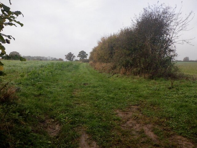
Stocking Wood is a picturesque woodland located in Herefordshire, a county in the West Midlands region of England. Covering an area of approximately 100 acres, it is a popular destination for nature lovers, hikers, and wildlife enthusiasts.

The wood is characterized by its diverse range of tree species, including oak, ash, beech, and birch, creating a rich and vibrant ecosystem. These trees provide a canopy that offers shade and shelter to various flora and fauna inhabiting the area. Bluebells, foxgloves, and primroses are just a few of the wildflowers that bloom in abundance during the spring season.

Tranquil pathways wind their way through the wood, allowing visitors to explore its beauty and enjoy a peaceful walk in nature. The air is filled with the sweet scent of pine and the songs of birds, creating a serene and relaxing atmosphere.

Stocking Wood is also home to a wide variety of wildlife. Deer, badgers, and squirrels can often be spotted roaming freely, while numerous bird species, such as robins, thrushes, and woodpeckers, find sanctuary within the trees. This makes it an ideal location for birdwatching and animal enthusiasts.

The wood is owned and managed by the local forestry commission, ensuring its preservation and conservation for future generations to enjoy. It also serves as an educational resource, with guided tours and workshops offered to schools and community groups.

Overall, Stocking Wood is a natural haven that offers a tranquil escape from the hustle and bustle of everyday life, providing visitors with the opportunity to immerse themselves in the beauty of Herefordshire's woodlands.

If you have any feedback on the listing, please let us know in the comments section below.

Stocking Wood Images

Images are sourced within 2km of 52.162554/-2.8476805 or Grid Reference SO4251. Thanks to Geograph Open Source API. All images are credited.

Lower Chadnor
Lower Chadnor
Magnus the Magpie sculpture Magnus the Magpie sculpture by Walenty Pytel in Weobley.  It was commissioned by Weobley Parish Council to celebrate village of the year in 1999.
Magnus the Magpie sculpture
Magnus the Magpie sculpture by Walenty Pytel in Weobley. It was commissioned by Weobley Parish Council to celebrate village of the year in 1999.
Ye Olde Salutation Inn Ye Olde Salutation Inn in Weobley <a href="https://www.geograph.org.uk/photo/7170484">SO4051 : Inn sign</a>.
Ye Olde Salutation Inn
Ye Olde Salutation Inn in Weobley SO4051 : Inn sign.
Inn sign Ye Olde Salutation Inn sign <a href="https://www.geograph.org.uk/photo/7170482">SO4051 : Ye Olde Salutation Inn</a>.
Inn sign
Ye Olde Salutation Inn sign SO4051 : Ye Olde Salutation Inn.
Timber-framed house A timber-frame building reminiscent of Weald houses of south-east England.  A Grade II* listed building, see: <span class="nowrap"><a title="https://historicengland.org.uk/listing/the-list/list-entry/1349837?section=official-list-entry" rel="nofollow ugc noopener" href="https://historicengland.org.uk/listing/the-list/list-entry/1349837?section=official-list-entry">Link</a><img style="margin-left:2px;" alt="External link" title="External link - shift click to open in new window" src="https://s1.geograph.org.uk/img/external.png" width="10" height="10"/></span>
Timber-framed house
A timber-frame building reminiscent of Weald houses of south-east England. A Grade II* listed building, see: LinkExternal link
Buildings on Weobley High Street Opposite the Unicorn Inn
Buildings on Weobley High Street
Opposite the Unicorn Inn
Oast House Ridge ventilated oast house.
Oast House
Ridge ventilated oast house.
Modern Fingerpost, Weobley Surrounded on three sides by Broad Street, Portland Street and High Street. This metal post has replaced a wooden post sometime after 2016. See the previous incarnation on <a href="https://www.geograph.org.uk/photo/2549317">SO4051 : Weobley signpost</a>. Weobley lies 15km NW of Hereford.
Modern Fingerpost, Weobley
Surrounded on three sides by Broad Street, Portland Street and High Street. This metal post has replaced a wooden post sometime after 2016. See the previous incarnation on SO4051 : Weobley signpost. Weobley lies 15km NW of Hereford.
Old Fingerpost, Weobley Old fingerpost with ball finial, and modern fingers, in a mix of local facilities and its distant city. For an earlier view from 2013 see <a href="https://www.geograph.org.uk/photo/3648627">SO4051 : Village signpost, Weobley</a>.

Inscription: Hereford 12 // car park / toilet // surgery / village hall

Milestone Society National ID: HF_SO4051C
Old Fingerpost, Weobley
Old fingerpost with ball finial, and modern fingers, in a mix of local facilities and its distant city. For an earlier view from 2013 see SO4051 : Village signpost, Weobley. Inscription: Hereford 12 // car park / toilet // surgery / village hall Milestone Society National ID: HF_SO4051C
Former Corn Mill Former mid-19th century Corn Mill in Weobley, now converted to residential accommodation.  The building is Grade II listed, see: <span class="nowrap"><a title="https://historicengland.org.uk/listing/the-list/list-entry/1166662?section=official-list-entry" rel="nofollow ugc noopener" href="https://historicengland.org.uk/listing/the-list/list-entry/1166662?section=official-list-entry">Link</a><img style="margin-left:2px;" alt="External link" title="External link - shift click to open in new window" src="https://s1.geograph.org.uk/img/external.png" width="10" height="10"/></span>
Former Corn Mill
Former mid-19th century Corn Mill in Weobley, now converted to residential accommodation. The building is Grade II listed, see: LinkExternal link
Former Bear Inn Today this is two houses, in the 17th and 18th centuries this was the Bear Inn.  From 1628 until the Reform Act of 1832 Weobley was a 'Rotten Borough' under the patronage of the Thynne family, the Marquises of Bath of Longleat.  It was from a balcony on the front of this building that parliamentary candidates would campaign and where election results would be proclaimed.
Former Bear Inn
Today this is two houses, in the 17th and 18th centuries this was the Bear Inn. From 1628 until the Reform Act of 1832 Weobley was a 'Rotten Borough' under the patronage of the Thynne family, the Marquises of Bath of Longleat. It was from a balcony on the front of this building that parliamentary candidates would campaign and where election results would be proclaimed.
The Throne Today this is a house named 'The Throne', in September 1645 after his defeat at Nasby King Charles I stayed here.  At the time this was The Crown Inn.  The building is Grade II* listed, see: <span class="nowrap"><a title="https://historicengland.org.uk/listing/the-list/list-entry/1081899?section=official-list-entry" rel="nofollow ugc noopener" href="https://historicengland.org.uk/listing/the-list/list-entry/1081899?section=official-list-entry">Link</a><img style="margin-left:2px;" alt="External link" title="External link - shift click to open in new window" src="https://s1.geograph.org.uk/img/external.png" width="10" height="10"/></span>
The Throne
Today this is a house named 'The Throne', in September 1645 after his defeat at Nasby King Charles I stayed here. At the time this was The Crown Inn. The building is Grade II* listed, see: LinkExternal link
Weobley Church Weobley church is dedicated to St Peter and St Paul.
Weobley Church
Weobley church is dedicated to St Peter and St Paul.
PC Coaches of Lincoln PC Coaches of Lincoln in picturesque former market town of Weobley.
PC Coaches of Lincoln
PC Coaches of Lincoln in picturesque former market town of Weobley.
Old Corn Mill, Weobley In a village noted for its timber framed buildings and with 89 listed structures, this one is a little different, being a 19thC corn mill which has found a new life as apartments. Grade II listed, as are the mill cottages beyond the main building.
Old Corn Mill, Weobley
In a village noted for its timber framed buildings and with 89 listed structures, this one is a little different, being a 19thC corn mill which has found a new life as apartments. Grade II listed, as are the mill cottages beyond the main building.
The Old Salutation Inn Inn facing down the main street in the village and made from two houses, the more obvious timber framed building to the right being the oldest part dating from the 17th century.
The Old Salutation Inn
Inn facing down the main street in the village and made from two houses, the more obvious timber framed building to the right being the oldest part dating from the 17th century.
Unicorn House, Weobley This fine timber framed building together with the one beyond were at one time both part of a village inn/hotel, but this end is now a private residence. The building dates back to the 14th century and is grade II* listed.
Unicorn House, Weobley
This fine timber framed building together with the one beyond were at one time both part of a village inn/hotel, but this end is now a private residence. The building dates back to the 14th century and is grade II* listed.
Show me another place!

Stocking Wood is located at Grid Ref: SO4251 (Lat: 52.162554, Lng: -2.8476805)

Unitary Authority: County of Herefordshire

Police Authority: West Mercia

What 3 Words

///pinks.unlisted.groups. Near Weobley, Herefordshire

Related Wikis

Weobley High School

Weobley High School is a mixed secondary school located in Weobley in the English county of Herefordshire. It is a community school administered by Herefordshire...

Weobley

Weobley ( WEB-lee) is an ancient settlement and civil parish in Herefordshire, England. Formerly a market town, the market is long defunct and the settlement...

Weobley Castle, Herefordshire

Weobley Castle was a ringwork and bailey castle in the English county of Herefordshire (grid reference SO40365135). The castle belonged to the De Lacy...

King's Pyon

King's Pyon is a village and civil parish in the county of Herefordshire, England, and is approximately 8 miles (13 km) north-west from the city and county...

Nearby Amenities

Located within 500m of 52.162554,-2.8476805
Power: pole
Source: bing
Lat/Long: 52.1643869/-2.8541762
Power: pole
Source: bing
Lat/Long: 52.1648344/-2.8521538
Power: pole
Source: bing
Lat/Long: 52.1653806/-2.8511024
Power: pole
Source: bing
Lat/Long: 52.1659203/-2.8501314
Power: pole
Source: bing
Lat/Long: 52.1665718/-2.848919
Power: pole
Lat/Long: 52.1647061/-2.8492034
The data included in this document is from www.openstreetmap.org. The data is made available under ODbL.

Have you been to Stocking Wood?

Leave your review of Stocking Wood below (or comments, questions and feedback).