Palace Coppice

Wood, Forest in Shropshire

England

Palace Coppice

The Fish is down the hill and The Wart is straight on
The Fish is down the hill and The Wart is straight on Credit: Row17

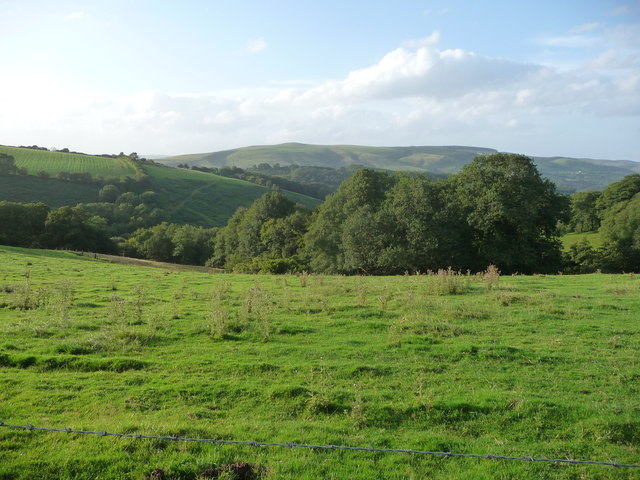
Palace Coppice is a picturesque woodland located in the county of Shropshire, England. Situated near the village of Much Wenlock, the coppice spans an area of approximately 100 acres and is a popular destination for nature enthusiasts and walkers alike.

The woodland is predominantly composed of native broadleaf trees, including oak, ash, beech, and birch. These towering trees create a dense canopy that provides shelter and habitat for a diverse range of wildlife, such as squirrels, deer, and a variety of bird species.

One of the standout features of Palace Coppice is its network of walking trails and paths. These well-maintained routes wind their way through the woodland, offering visitors the opportunity to explore its natural beauty. The paths vary in length and difficulty, catering to both casual strollers and more adventurous hikers.

In addition to its natural charm, Palace Coppice holds historical significance. It is believed that the woodland was once part of the hunting grounds of Wenlock Priory, a medieval monastery that dates back to the 12th century. Remnants of ancient stone structures can still be found within the coppice, adding an element of mystery and intrigue to the area.

Overall, Palace Coppice is a serene and enchanting woodland that offers visitors a chance to immerse themselves in nature. With its rich biodiversity, well-maintained trails, and historical allure, it is no wonder that this Shropshire gem attracts visitors from near and far.

If you have any feedback on the listing, please let us know in the comments section below.

Palace Coppice Images

Images are sourced within 2km of 52.461681/-2.8766271 or Grid Reference SO4085. Thanks to Geograph Open Source API. All images are credited.

The Fish is down the hill and The Wart is straight on
Turn right for Hopesay
Lane junction in Round Oak Shropshire has its share of intriguing place names, but 'The Fish' is surely right up there with the best.
Lane junction in Round Oak
Shropshire has its share of intriguing place names, but 'The Fish' is surely right up there with the best.
Road sign at Round Oak Nice accoutrement.
Road sign at Round Oak
Nice accoutrement.
View to the southern end of the Long Mynd from near Upper Carwood Black Knoll is visible on the ridge up. A fave walk of mine is all along the Long Mynd from the southern end northwards.
View to the southern end of the Long Mynd from near Upper Carwood
Black Knoll is visible on the ridge up. A fave walk of mine is all along the Long Mynd from the southern end northwards.
Grassland, Edgton
Grassland, Edgton
St Michael, Edgton A small and simple 13th century church, originally an 'outreach' of Clun.
St Michael, Edgton
A small and simple 13th century church, originally an 'outreach' of Clun.
St Michael, Edgton A small and simple 13th century church, originally an 'outreach' of Clun. The West front.
St Michael, Edgton
A small and simple 13th century church, originally an 'outreach' of Clun. The West front.
St Michael, Edgton A small and simple 13th century church, originally an 'outreach' of Clun. The plain North side.
St Michael, Edgton
A small and simple 13th century church, originally an 'outreach' of Clun. The plain North side.
St Michael, Edgton An 18th century sundial by the West door. Warning to passing Geographers - don't lean on it.
St Michael, Edgton
An 18th century sundial by the West door. Warning to passing Geographers - don't lean on it.
Sundial, St Michael, Edgton Dating from 1749, at the West door of the church and very fragile; a thing of beauty, nevertheless.
Sundial, St Michael, Edgton
Dating from 1749, at the West door of the church and very fragile; a thing of beauty, nevertheless.
St Michael, Edgton An unusual position for gravestones.
St Michael, Edgton
An unusual position for gravestones.
St Michael, Edgton The simple but charming interior, with a complete set of box pews.
St Michael, Edgton
The simple but charming interior, with a complete set of box pews.
St Michael, Edgton The plain tub font, right by the West door.
St Michael, Edgton
The plain tub font, right by the West door.
Round Oak Looking up the hope towards the scattered houses at Round Oak.
Round Oak
Looking up the hope towards the scattered houses at Round Oak.
Machinery, Round Oak Assorted tools for arable farming in a field near Round Oak.
Machinery, Round Oak
Assorted tools for arable farming in a field near Round Oak.
Sheep troughs The sheep have been moved, leaving left overs for other livestock.
Sheep troughs
The sheep have been moved, leaving left overs for other livestock.
Behind Wart Hill Start of a stream running to the north of Wart Hill towards Cheney Longville.
Behind Wart Hill
Start of a stream running to the north of Wart Hill towards Cheney Longville.
Show me another place!

Palace Coppice is located at Grid Ref: SO4085 (Lat: 52.461681, Lng: -2.8766271)

Unitary Authority: Shropshire

Police Authority: West Mercia

What 3 Words

///harmlessly.masking.cube. Near Craven Arms, Shropshire

Related Wikis

Cheney Longville Castle

Cheney Longville Castle was in the village of Cheney Longville to the north of Craven Arms, Shropshire (grid reference SO417847). It is a much restored...

Cheney Longville

Cheney Longville ( SHEH-nee LONG-vil) is a small village in Shropshire, England. It lies in the parish of Wistanstow, near to the small market town of...

Horderley railway station

Horderley railway station was a station in Horderley, Wistanstow, Shropshire, England. The station was opened in March 1866 and closed on 20 April 1935...

Edgton

Edgton is a small village and civil parish in Shropshire, England. It is also an ecclesiastical parish and a chapelry. It lies in a rather remote and very...

Nearby Amenities

Located within 500m of 52.461681,-2.8766271
Power: pole
Ref: 745223
Source: wpd_open_data
Transformer: distribution
Lat/Long: 52.4603797/-2.8789893
Power: pole
Source: bing
Lat/Long: 52.4609566/-2.880156
Power: pole
Source: bing
Lat/Long: 52.4614518/-2.8811216
Power: pole
Ref: 745264
Source: wpd_open_data
Transformer: distribution
Lat/Long: 52.4621325/-2.8828007
Power: pole
Source: bing
Lat/Long: 52.4617353/-2.8835209
Barrier: stile
Lat/Long: 52.4627802/-2.882836
Barrier: stile
Lat/Long: 52.4634444/-2.8815675
The data included in this document is from www.openstreetmap.org. The data is made available under ODbL.

Have you been to Palace Coppice?

Leave your review of Palace Coppice below (or comments, questions and feedback).