Oakthorpen Wood

Wood, Forest in Westmorland South Lakeland

England

Oakthorpen Wood

Shell Garage forecourt. Troutbeck Bridge
Shell Garage forecourt. Troutbeck Bridge Credit: Eirian Evans

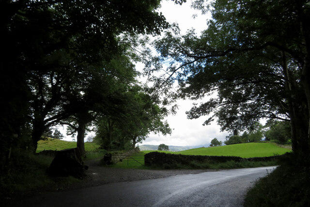
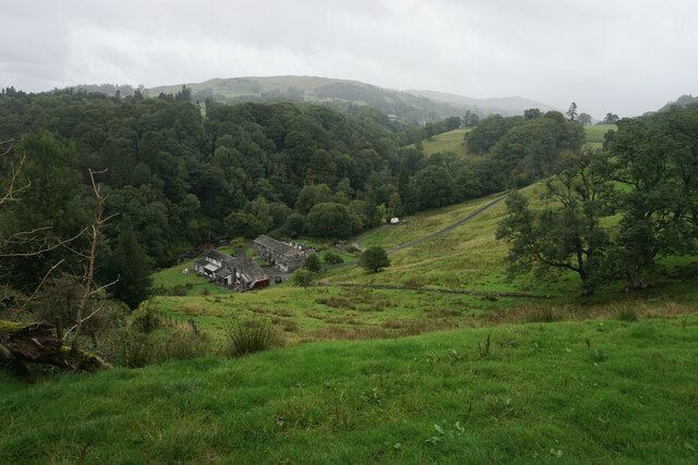
Oakthorpen Wood is a picturesque forest located in the county of Westmorland in northwestern England. Spread across a sprawling area, this woodland is an enchanting sight that captivates visitors with its natural beauty and diverse flora and fauna.

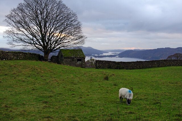
The wood is primarily composed of oak trees, which give it its name. These magnificent trees tower above the forest floor, creating a dense canopy that provides shade and shelter to the numerous species that inhabit the area. The towering oaks also lend an air of tranquility to Oakthorpen Wood, making it a popular destination for nature enthusiasts and those seeking a peaceful retreat.

As visitors venture deeper into the wood, they are greeted by a carpet of vibrant wildflowers that bloom in the spring and summer months. The fragrant scent of bluebells, primroses, and wood anemones fills the air, creating a sensory experience that is both calming and invigorating.

The forest is also home to a rich variety of wildlife. Squirrels can be spotted darting between the trees, while birdsong fills the air as various avian species flit about. Keen-eyed visitors may even catch a glimpse of a deer or two gracefully moving through the undergrowth.

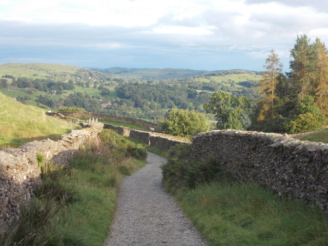
Tranquil walking paths wind their way through Oakthorpen Wood, allowing visitors to explore its wonders at their own pace. These paths offer opportunities for both leisurely strolls and more adventurous hikes, ensuring that there is something for everyone to enjoy.

Overall, Oakthorpen Wood is a remarkable natural treasure in Westmorland, offering a serene escape from the hustle and bustle of everyday life. Its majestic oaks, colorful wildflowers, and abundant wildlife make it a must-visit destination for nature lovers and those seeking solace in the beauty of the great outdoors.

If you have any feedback on the listing, please let us know in the comments section below.

Oakthorpen Wood Images

Images are sourced within 2km of 54.404321/-2.9416782 or Grid Reference NY3801. Thanks to Geograph Open Source API. All images are credited.

Shell Garage forecourt. Troutbeck Bridge
Fields and footpath near a bend in the road
Farmland by Robin Lane Field barn and grazing land above Troutbeck. Windermere is in the distance.
Farmland by Robin Lane
Field barn and grazing land above Troutbeck. Windermere is in the distance.
Car park and beer garden for the Sun Inn, Troutbeck Bridge
Mill House A small cluster of dwellings by Trout Beck, viewed from Patterdale Road.
Mill House
A small cluster of dwellings by Trout Beck, viewed from Patterdale Road.
Bus stop at Troutbeck Bridge
Robin Lane (bridleway) A view towards Allen Knott and Holehird in the distance.
Robin Lane (bridleway)
A view towards Allen Knott and Holehird in the distance.
Looking east along Hundreds Road in the snow
Wain Lane
Wain Lane
Holehird Tarn
Holehird Tarn
Countryside at Troutbeck Bridge Country as seen from one end of the car park dedicated for the customer's of Pedro's Restaurant on the A591, Ambleside Road
Countryside at Troutbeck Bridge
Country as seen from one end of the car park dedicated for the customer's of Pedro's Restaurant on the A591, Ambleside Road
Wain Lane Walled green lane leading from Holbeck Lane down to the A591 on the shores of Windermere near Ecclerigg.
Wain Lane
Walled green lane leading from Holbeck Lane down to the A591 on the shores of Windermere near Ecclerigg.
Track ascending towards Robin Lane Leaving Holbeck Lane, there is a sign indicating this is the Windermere Way. I actually had never heard of it, but research suggests that it is a 45 miles long distance footpath that circles roughly around England's largest lake.
Track ascending towards Robin Lane
Leaving Holbeck Lane, there is a sign indicating this is the Windermere Way. I actually had never heard of it, but research suggests that it is a 45 miles long distance footpath that circles roughly around England's largest lake.
Town End 17th century farmhouse, full of quirky rooms and objects, now under the stewardship of the National Trust
Town End
17th century farmhouse, full of quirky rooms and objects, now under the stewardship of the National Trust
A View over the Valley of Trout Beck
Robin Lane
Robin Lane
Wain Lane
Wain Lane
Show me another place!

Oakthorpen Wood is located at Grid Ref: NY3801 (Lat: 54.404321, Lng: -2.9416782)

Administrative County: Cumbria

District: South Lakeland

Police Authority: Cumbria

What 3 Words

///basically.foot.smiling. Near Windermere, Cumbria

Related Wikis

Langdale Chase

Langdale Chase, Windermere is a house of historical significance and is listed on the English heritage register. It consists of six acres of landscaped...

Brockhole

The Brockhole Lake District Visitor Centre, also known as the Brockhole National Park Visitor Centre, is a visitor centre and tourist attraction managed...

Holbeck Ghyll

Holbeck Ghyll is a restaurant located in Windermere, Cumbria, England. "The late 19th century building was once Lord Lonsdale's hunting lodge and only...
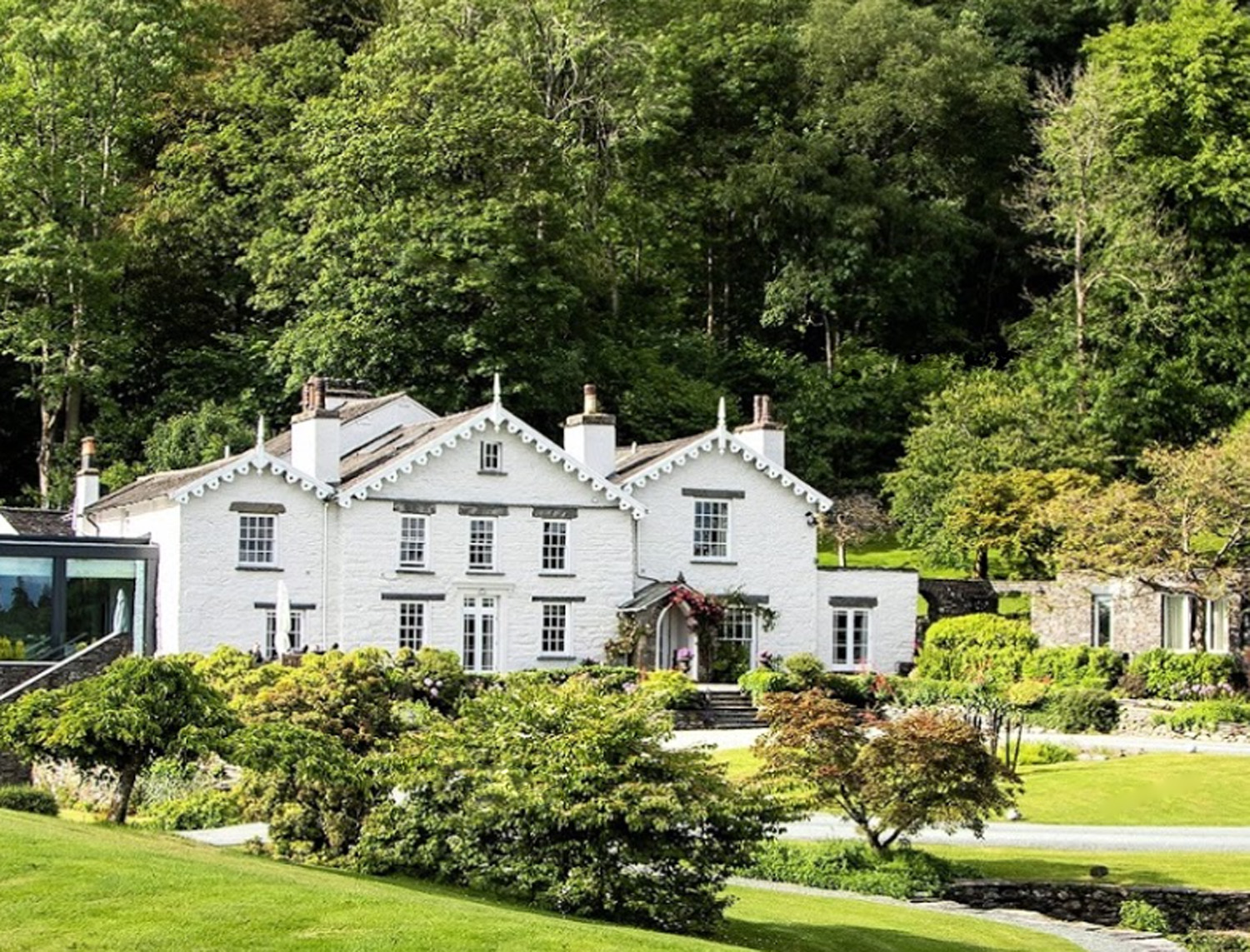
The Samling Hotel

The Samling Hotel (previously known as Dove Nest) near Windermere is a building of historical significance and is listed on the English Heritage. It was...
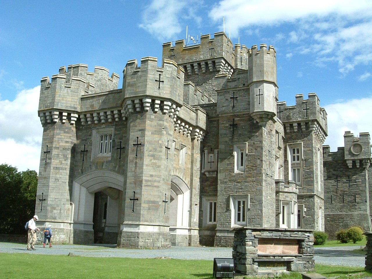
Wray Castle

Wray Castle is a Victorian neo-gothic building at Claife in Cumbria within the boundaries of the historic county of Lancashire. The house and grounds have...

RMS Wray Castle

RMS Wray Castle was a training college for Merchant Navy radio officers based at Wray Castle in the Lake District, from 1958 to 1998.At 11:40 p.m., on...

Stagshaw Garden

Stagshaw Garden is a woodland garden situated south of Ambleside, in Cumbria, England, and in the ownership of the National Trust.The garden is noted for...

The Lakes School

The Lakes School is a coeducational secondary school and sixth form located in Troutbeck Bridge, Windermere, in the English county of Cumbria.It is a comprehensive...

Nearby Amenities

Located within 500m of 54.404321,-2.9416782
Crossing
Crossing: uncontrolled
Crossing Island: yes
Kerb: flush
Tactile Paving: no
Lat/Long: 54.4009684/-2.9383334
Source: Landsat photo
Lat/Long: 54.4070529/-2.9477665
Source: Landsat photo
Lat/Long: 54.4066096/-2.9475733
Source: Landsat photo
Lat/Long: 54.4054231/-2.9463181
Source: Landsat photo
Lat/Long: 54.4052982/-2.9464575
Source: Landsat photo
Lat/Long: 54.4048486/-2.9458996
Source: Landsat photo
Lat/Long: 54.4040373/-2.9456565
Source: Landsat photo
Lat/Long: 54.4036187/-2.9458019
Source: Landsat photo
Lat/Long: 54.4029931/-2.9455436
Source: Landsat photo
Lat/Long: 54.4017727/-2.9451602
Source: Landsat photo
Lat/Long: 54.4011692/-2.9458939
Bus Stop
Brockhole
Bench: yes
Bin: no
Bus: yes
Check Date Shelter: 2023-08-03
Lit: no
Naptan AtcoCode: 090079412120
Naptan Bearing: E
Naptan BusStopType: MKD
Naptan CommonName: Visitor Centre
Naptan Indicator: near
Naptan Landmark: entrance
Naptan LocalityCode: N0080634
Naptan NaptanCode: cumdjwgt
Naptan PlusbusZoneRef: WMER
Naptan Street: A591
Naptan Verified: yes
Public Transport: platform
Ref: cumdjwgt
Shelter: yes
Source: naptan_import
Tactile Paving: no
Lat/Long: 54.4008935/-2.9379191
Noexit: yes
Lat/Long: 54.400151/-2.9420654
Noexit: yes
Lat/Long: 54.4006044/-2.9432774
Bench
Lat/Long: 54.3999938/-2.9421246
Bench
Lat/Long: 54.4000188/-2.9419596
Bench
Lat/Long: 54.4001453/-2.9420629
Bench
Lat/Long: 54.4001984/-2.941977
Bench
Lat/Long: 54.4001117/-2.9420213
Bench
Lat/Long: 54.4001016/-2.9421501
Give Way
Direction: forward
Lat/Long: 54.4010864/-2.9388018
Give Way
Direction: forward
Lat/Long: 54.4024957/-2.941756
Bus Stop
Brockhole National Park Centre
Bench: no
Bin: no
Bus: yes
Lit: no
Naptan AtcoCode: 090079413668
Naptan Bearing: W
Naptan BusStopType: MKD
Naptan CommonName: Brockhole National Park Centre
Naptan Indicator: by
Naptan Landmark: Brockhole National Park Centre
Naptan LocalityCode: N0080634
Naptan NaptanCode: cumdjwta
Naptan PlusbusZoneRef: WMER
Naptan Street: A591
Naptan Verified: yes
Public Transport: platform
Ref: cumdjwta
Shelter: yes
Source: naptan_import
Tactile Paving: no
Lat/Long: 54.4007324/-2.9377793
Give Way
Direction: forward
Lat/Long: 54.4007828/-2.937898
Post Box
Ref: LA23 123
Lat/Long: 54.4015835/-2.940114
Treetop Trek
Addr City: Windermere
Addr Postcode: LA23 1LJ
Sport: climbing_adventure
Tourism: attraction
Lat/Long: 54.4010193/-2.940632
Cafe
Brockhole Cafe
Addr City: Windermere
Addr Housename: Brockhole
Addr Postcode: LA23 1LJ
Diet Vegetarian: yes
Outdoor Seating: yes
Website: https://www.brockhole.co.uk/activities/brockhole-cafe/
Lat/Long: 54.4007158/-2.9422052
Information: office
Tourism: information
Lat/Long: 54.400945/-2.9421443
Toilets
Lat/Long: 54.4010757/-2.9405529
Entrance: main
Lat/Long: 54.4011818/-2.9391294
Give Way
Direction: forward
Lat/Long: 54.4017414/-2.9400046
Give Way
Direction: forward
Lat/Long: 54.4008967/-2.9380001
Give Way
Direction: backward
Lat/Long: 54.4011982/-2.9391108
Give Way
Direction: forward
Lat/Long: 54.4018913/-2.9405932
Give Way
Direction: backward
Lat/Long: 54.4026216/-2.941781
Give Way
Direction: backward
Lat/Long: 54.4033604/-2.9432784
Give Way
Direction: forward
Lat/Long: 54.4035313/-2.9433522
Give Way
Direction: backward
Lat/Long: 54.404654/-2.9433426
Give Way
Direction: backward
Lat/Long: 54.4053986/-2.9435479
Give Way
Direction: forward
Lat/Long: 54.4064842/-2.9451501
Give Way
Direction: backward
Lat/Long: 54.4058769/-2.9443571
Give Way
Direction: forward
Lat/Long: 54.4070198/-2.9456412
Give Way
Direction: backward
Lat/Long: 54.4078188/-2.9460915
Brockhole National Park Centre
Bus: yes
Public Transport: stop_position
Lat/Long: 54.4007884/-2.937742
Brockhole
Bus: yes
Public Transport: stop_position
Lat/Long: 54.4008441/-2.9379573
Crag Wood
Natural: wood
Lat/Long: 54.4032736/-2.9414199
Oakthorpen Wood
Natural: wood
Lat/Long: 54.4042719/-2.9422919
Newclose Wood
Natural: wood
Lat/Long: 54.4055662/-2.9379752
Cockshot Wood
Natural: wood
Lat/Long: 54.4064883/-2.9384839
Bicycle Rental
Lat/Long: 54.4005469/-2.9449396
Charging Station
Lat/Long: 54.4011527/-2.9419824
Restaurant
The Gaddum
Addr City: Windermere
Addr Housename: Brockhole
Addr Postcode: LA23 1LJ
Website: https://thegaddumrestaurant.co.uk/
Lat/Long: 54.4006284/-2.9418099
Cafe
The Garden Shed
Addr City: Windermere
Addr Housename: Brockhole
Addr Postcode: LA23 1LJ
Cuisine: ice_cream;cake;sandwich
Outdoor Seating: yes
Takeaway: yes
Lat/Long: 54.3998971/-2.9413328
Power: pole
Lat/Long: 54.4071141/-2.9364744
Give Way
Direction: backward
Lat/Long: 54.4018963/-2.9406953
Give Way
Direction: forward
Lat/Long: 54.4018317/-2.940571
Give Way
Direction: forward
Lat/Long: 54.4024667/-2.941748
Give Way
Direction: backward
Lat/Long: 54.4025282/-2.941864
Give Way
Direction: forward
Lat/Long: 54.4027944/-2.9423621
Give Way
Direction: backward
Lat/Long: 54.4028246/-2.9424206
Give Way
Direction: forward
Lat/Long: 54.402816/-2.9423711
Give Way
Direction: backward
Lat/Long: 54.4034636/-2.9433934
Give Way
Direction: forward
Lat/Long: 54.4033005/-2.9432526
Charging Station
Access: customers
Bicycle: yes
Motorcar: no
Operator: Brockhole
Website: https://www.visitlakedistrict.com/explore/travel/electric-bike-charging-points-in-the-lake-district-cumbria
Lat/Long: 54.4010453/-2.9419681
Ice Cream
Lat/Long: 54.4009402/-2.9452461
Leisure: miniature_golf
Lat/Long: 54.4010689/-2.9453451
The data included in this document is from www.openstreetmap.org. The data is made available under ODbL.

Have you been to Oakthorpen Wood?

Leave your review of Oakthorpen Wood below (or comments, questions and feedback).