Apethorpe

Settlement in Northamptonshire

England

Apethorpe

Spa Farm Cottages The cottage to the right appears to be quite new.
Spa Farm Cottages Credit: Kokai

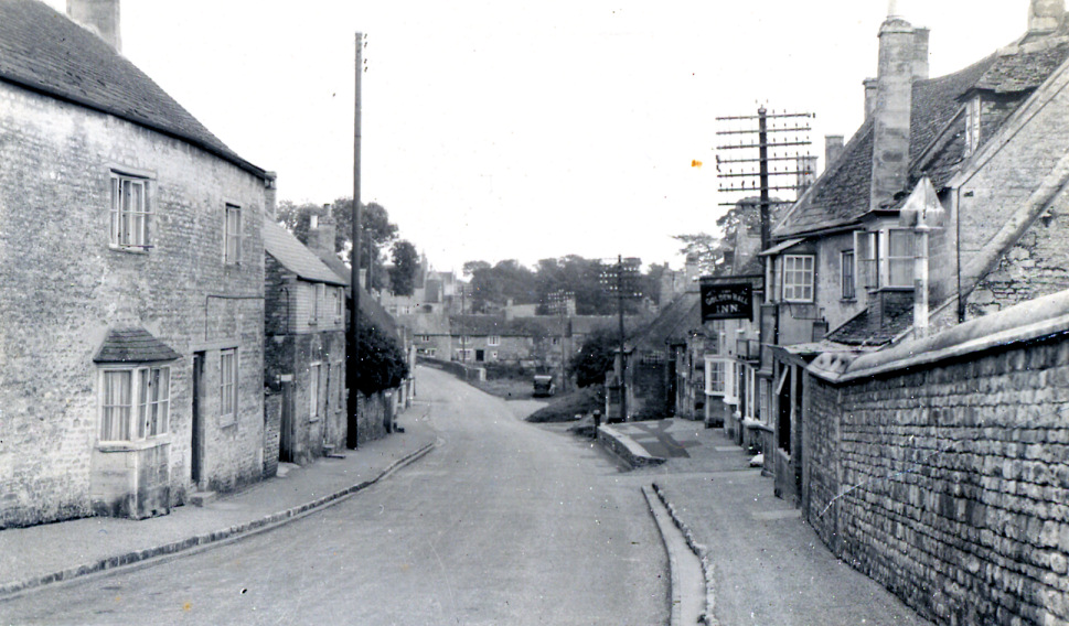
Apethorpe is a small village located in the county of Northamptonshire, England. Situated approximately 12 miles northeast of the town of Northampton, Apethorpe is known for its picturesque countryside and rich historical heritage.

The village is home to a population of around 400 residents and is characterized by its charming stone-built houses and quaint village green. Apethorpe has a close-knit community feel, with various local activities and events organized throughout the year, fostering a sense of community spirit among its residents.

One of the main attractions in Apethorpe is Apethorpe Palace, a Grade I listed country house that dates back to the 15th century. The palace is renowned for its stunning architecture and beautiful gardens, attracting visitors from near and far. Additionally, Apethorpe Palace has served as a residence for various English monarchs, including Henry VIII and Elizabeth I, adding to its historical significance.

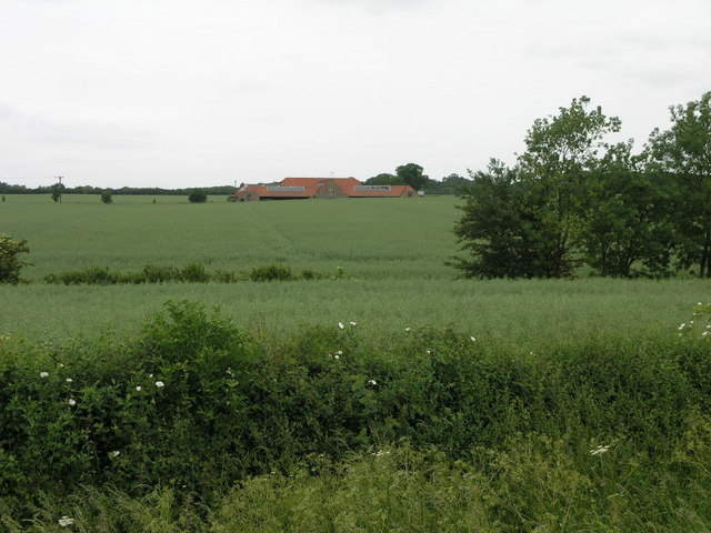
Surrounded by rolling countryside, Apethorpe offers numerous opportunities for outdoor activities such as hiking, cycling, and horse riding. The village is also within close proximity to the historic market towns of Oundle and Stamford, both known for their charming architecture and vibrant local markets.

Overall, Apethorpe is a tranquil and idyllic village that offers a peaceful retreat for residents and visitors alike. Its rich history, stunning landscapes, and strong community spirit make it a truly unique place to explore in Northamptonshire.

If you have any feedback on the listing, please let us know in the comments section below.

Apethorpe Images

Images are sourced within 2km of 52.549806/-0.492363 or Grid Reference TL0295. Thanks to Geograph Open Source API. All images are credited.

Spa Farm Cottages The cottage to the right appears to be quite new.
Spa Farm Cottages
The cottage to the right appears to be quite new.
Lodge Farm View from near the bridleway that runs along the north of the Lodge.
Lodge Farm
View from near the bridleway that runs along the north of the Lodge.
A Section of Tomlin Wood This is quite an extensive wood.
A Section of Tomlin Wood
This is quite an extensive wood.
Church Tower at Apethorpe Nice young horse, I thought, when it walked into the picture unexpectedly.
Church Tower at Apethorpe
Nice young horse, I thought, when it walked into the picture unexpectedly.
Hedge marking a Parish Boundary Taken from a footpath linking the villages of Apethorpe and King's Cliffe.  The hedge marks the parish boundary between those two villages.
Hedge marking a Parish Boundary
Taken from a footpath linking the villages of Apethorpe and King's Cliffe. The hedge marks the parish boundary between those two villages.
Clay Pits A view west from a footpath at the east end of this pit - ie. the quarry extends into grid square TL0096.
Clay Pits
A view west from a footpath at the east end of this pit - ie. the quarry extends into grid square TL0096.
Stocks and Whipping Post At Apethorpe
Stocks and Whipping Post
At Apethorpe
Resting Place of Coco the Clown In Woodnewton Parish Churchyard.  The inscription on the gravestone begins 'In Loving Memory of Nicolai Polakovs O.B.E. (Coco the Clown)'.  Died 25th Sept 1974 aged 74.  His wife Valentina is also buried there, 1983, aged 82.
Resting Place of Coco the Clown
In Woodnewton Parish Churchyard. The inscription on the gravestone begins 'In Loving Memory of Nicolai Polakovs O.B.E. (Coco the Clown)'. Died 25th Sept 1974 aged 74. His wife Valentina is also buried there, 1983, aged 82.
St Mary's Church, Woodnewton Taken from Main Street.
St Mary's Church, Woodnewton
Taken from Main Street.
Main Street, Woodnewton The White Swan P H can be seen on the left of the street.
Main Street, Woodnewton
The White Swan P H can be seen on the left of the street.
Hill with Trees on Top Other than two short lengths of road that chop through its corners and a small patch of trees this square is just fields.
Hill with Trees on Top
Other than two short lengths of road that chop through its corners and a small patch of trees this square is just fields.
Red in Green These red farm buildings in a sea of green fields is known as Bluefield Farm.
Red in Green
These red farm buildings in a sea of green fields is known as Bluefield Farm.
Green Arch Bridleway This bridleway leads to Bedford Purlieus Wood two square to the north.
Green Arch Bridleway
This bridleway leads to Bedford Purlieus Wood two square to the north.
Kings Cliffe Airfield Little remains of Kings Cliffe airfield.  The buildings are mostly gone and much of it has been returned to agriculture although a few traces of broken roadway can still be seen.  A memorial <a href="https://www.geograph.org.uk/gridref/TL0298">TL0298</a> commemorates those who served here in the war.
Kings Cliffe Airfield
Little remains of Kings Cliffe airfield. The buildings are mostly gone and much of it has been returned to agriculture although a few traces of broken roadway can still be seen. A memorial TL0298 commemorates those who served here in the war.
Farm Buildings Near Apethorpe
Mill at Woodnewton This converted mill enjoys an idyllic location on Willow Brook at Woodnewton.
Mill at Woodnewton
This converted mill enjoys an idyllic location on Willow Brook at Woodnewton.
St Mary Woodnewton The round headed 12th century arch has been placed here at a later date
St Mary Woodnewton
The round headed 12th century arch has been placed here at a later date
Aerial view of Apethorpe
Show me another place!

Apethorpe is located at Grid Ref: TL0295 (Lat: 52.549806, Lng: -0.492363)

Unitary Authority: North Northamptonshire

Police Authority: Northamptonshire

What 3 Words

///munched.sparkles.skill. Near Wansford, Cambridgeshire

Nearby Locations

Apethorpe Apethorpe

Related Wikis

Apethorpe

Apethorpe (pronounced "Ap-thorp") is a village, civil parish, former manor and ecclesiastical parish in Northamptonshire, England (in the North Northamptonshire...

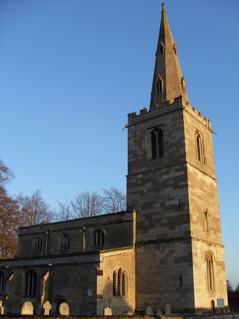
St Leonard's Church, Apethorpe

St Leonard's Church is an Anglican church in the village of Apethorpe in Northamptonshire, England. It is an active parish church in the Diocese of Peterborough...

Apethorpe Palace

Apethorpe Palace (pronounced Ap-thorp), formerly known as "Apethorpe Hall", is a Grade I listed country house, dating to the 15th century, close to Apethorpe...

Woodnewton

Woodnewton is a village in Northamptonshire, England. Essentially a pair of parallel streets, the village lies to the north of a small stream, the Willow...
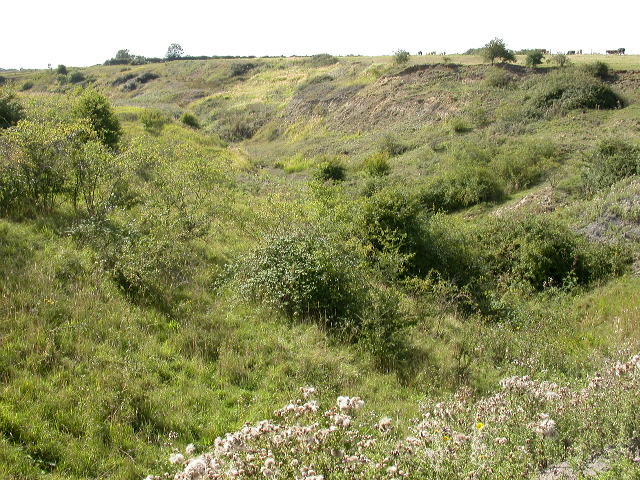
King's Cliffe Banks

King's Cliffe Banks is a 7.7-hectare (19-acre) biological Site of Special Scientific Interest in King's Cliffe in Northamptonshire.This former quarry has...

King's Cliffe railway station

King's Cliffe railway station is a former railway station in King's Cliffe, Northamptonshire. It was owned by the London and North Western Railway, being...
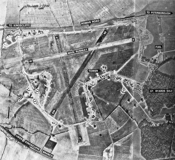
RAF Kings Cliffe

Royal Air Force Kings Cliffe or more simply RAF Kings Cliffe is a former Royal Air Force satellite station located near Kings Cliffe, Northamptonshire...

King's Cliffe

King's Cliffe (variously spelt Kings Cliffe, King's Cliff, Kings Cliff, Kingscliffe) is a village and civil parish on Willow Brook, a tributary of the...

Nearby Amenities

Located within 500m of 52.549806,-0.492363
Pub
The Willow And Brook
Addr City: Peterborough
Addr Country: GB
Addr Housename: The Kings Head Inn
Addr Postcode: PE8 5DG
Addr Street: Kings Cliffe Road
Addr Village: Apethorpe
Lat/Long: 52.5502698/-0.4925588
Historic: memorial
Memorial: war_memorial
Source: Bing
Lat/Long: 52.5496554/-0.4902276
Man Made: water_tower
Source: Bing
Lat/Long: 52.550833/-0.4927164
Apethorpe
Place: village
Lat/Long: 52.5499403/-0.4918954
Village Stocks
Historic: monument
Lat/Long: 52.5497894/-0.4902193
Public Bookcase
Defibrillator
Booth: K6
Colour: red
Defibrillator Location: inside red phone box (that is now book exchange) Kings Cliffe Road, Apethorpe
Disused Amenity: telephone
Emergency: defibrillator
Man Made: telephone_box
Public Bookcase Type: phone_box
Lat/Long: 52.5505783/-0.4922753
Post Box
Brand: Royal Mail
Brand Wikidata: Q638098
Brand Wikipedia: en:Royal Mail
Operator: Royal Mail
Operator Wikidata: Q638098
Post Box Type: wall
Lat/Long: 52.5497534/-0.4923809
The data included in this document is from www.openstreetmap.org. The data is made available under ODbL.

Have you been to Apethorpe?

Leave your review of Apethorpe below (or comments, questions and feedback).