Gill Wood

Wood, Forest in Lancashire South Lakeland

England

Gill Wood

A590 eastbound at Ayside
A590 eastbound at Ayside Credit: Colin Pyle

Gill Wood is a picturesque forest located in Lancashire, England. Covering an area of approximately 100 acres, it is a popular destination for nature lovers and outdoor enthusiasts. The wood is situated near the village of Wood, which lends its name to the forest.

Gill Wood is characterized by its diverse range of flora and fauna. The forest boasts a variety of tree species, including oak, beech, ash, and birch, which create a lush and vibrant canopy. The forest floor is covered in a thick carpet of ferns, mosses, and wildflowers, adding to its natural beauty.

The wood is home to numerous wildlife species, providing a habitat for birds, mammals, and insects. Birdwatchers can spot common species such as woodpeckers, robins, and thrushes, as well as rarer sightings like the tawny owl and the red kite. The forest is also inhabited by deer, foxes, badgers, and squirrels, among others.

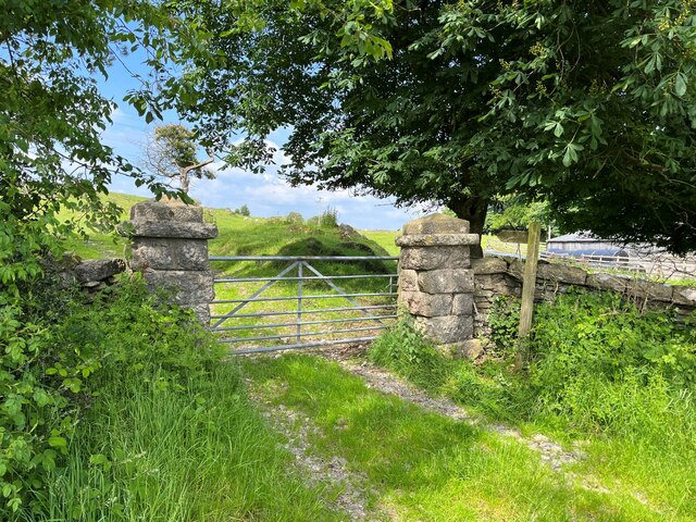
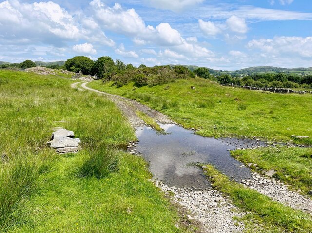
Gill Wood offers several walking trails and paths that wind through its enchanting landscape. Visitors can explore the forest at their own pace, immersing themselves in its tranquility and beauty. The wood also has designated picnic areas and benches, providing a perfect spot for a leisurely lunch surrounded by nature.

Additionally, Gill Wood is a designated Site of Special Scientific Interest (SSSI), recognizing its ecological importance and conservation value. The forest is managed by local authorities and conservation organizations to preserve its natural heritage and protect its diverse ecosystem.

In conclusion, Gill Wood in Lancashire is a captivating forest that offers a peaceful retreat for nature enthusiasts. With its scenic beauty, abundant wildlife, and well-maintained trails, it is a must-visit destination for anyone seeking solace in the great outdoors.

If you have any feedback on the listing, please let us know in the comments section below.

Gill Wood Images

Images are sourced within 2km of 54.237372/-2.9560229 or Grid Reference SD3782. Thanks to Geograph Open Source API. All images are credited.

A590 eastbound at Ayside
High and Low Newton By-pass The A590 north of Grange-Over-Sands
High and Low Newton By-pass
The A590 north of Grange-Over-Sands
Road near High Gateside The minor road from Low Wood to Cartmel and Field Broughton.
Road near High Gateside
The minor road from Low Wood to Cartmel and Field Broughton.
Gateway near High Gateside This gateway is at the end of a little used access drive to Greenhurst.  The gate posts are made from blocks of limestone.
A public footpath runs through the gate and there is an Ordnance Survey cut benchmark at the bottom of the right hand gatepost (photograph <a href="https://www.geograph.org.uk/photo/7195628">SD3781 : Benchmark, High Gateside</a>).
Gateway near High Gateside
This gateway is at the end of a little used access drive to Greenhurst. The gate posts are made from blocks of limestone. A public footpath runs through the gate and there is an Ordnance Survey cut benchmark at the bottom of the right hand gatepost (photograph SD3781 : Benchmark, High Gateside).
Benchmark, High Gateside Detail of an Ordnance Survey cut benchmark on the east gatepost of the driveway to Greenhurst.  The benchmark marks a height of 106.2786m above Ordnance Datum Newlyn last verified in 1972 (location photograph <a href="https://www.geograph.org.uk/photo/7195619">SD3781 : Gateway near High Gateside</a>).
Benchmark, High Gateside
Detail of an Ordnance Survey cut benchmark on the east gatepost of the driveway to Greenhurst. The benchmark marks a height of 106.2786m above Ordnance Datum Newlyn last verified in 1972 (location photograph SD3781 : Gateway near High Gateside).
Lane near High Cark This old lane, too narrow for modern vehicles links High Cark to Seatle.  It has fallen into disuse and on the central section the western boundary has largely been lost except for a few bushes and the bottom of the dyke.
The lane is a public footpath.
Lane near High Cark
This old lane, too narrow for modern vehicles links High Cark to Seatle. It has fallen into disuse and on the central section the western boundary has largely been lost except for a few bushes and the bottom of the dyke. The lane is a public footpath.
Ford near High Cark Hall Crossed by a public bridleway, a small stone clapper bridge is provided for pedestrians.
Ford near High Cark Hall
Crossed by a public bridleway, a small stone clapper bridge is provided for pedestrians.
Bigland Hall Trout Fishery
Farm Building at Hazelrigg
Monkey Puzzle Tree Ayside Not a native to South lakes the Chilean Pine popular with the Victorians pops up unexpectedly in Ayside.
Monkey Puzzle Tree Ayside
Not a native to South lakes the Chilean Pine popular with the Victorians pops up unexpectedly in Ayside.
St Peter's Church at Field Broughton Many places called Broughton in this square
St Peter's Church at Field Broughton
Many places called Broughton in this square
Ponies Seatle Seatle South Cumbria not North America
Ponies Seatle
Seatle South Cumbria not North America
Fells Newby Bridge Over the top from the coast road a miniature wilderness of rough grazing and little fells.
Fells Newby Bridge
Over the top from the coast road a miniature wilderness of rough grazing and little fells.
Wall Bigland Heights Bigland heights is a small area of low fells near newby Bridge
Wall Bigland Heights
Bigland heights is a small area of low fells near newby Bridge
Stile near Seatle Public Footpath which heads towards Ayside.Newton Fell on the horizon
Stile near Seatle
Public Footpath which heads towards Ayside.Newton Fell on the horizon
Whitestone Caravan Park On the A. 590
Whitestone Caravan Park
On the A. 590
Near High Cark On the road out of Barber Green
Near High Cark
On the road out of Barber Green
Near High Gateside Farm Rough Grazing
Near High Gateside Farm
Rough Grazing
Show me another place!

Gill Wood is located at Grid Ref: SD3782 (Lat: 54.237372, Lng: -2.9560229)

Administrative County: Cumbria

District: South Lakeland

Police Authority: Cumbria

What 3 Words

///lost.safest.livid. Near Grange-over-Sands, Cumbria

Related Wikis

St Peter's Church, Field Broughton

St Peter's Church is in the village of Field Broughton, Cumbria, England. It is an active Anglican parish church in the deanery of Windermere, the archdeaconry...

Cartmel Peninsula

Cartmel Peninsula is a peninsula in Cumbria in England. It juts in a southerly direction into Morecambe Bay, bordered by the estuaries of the River Leven...

Ayside

Ayside is a hamlet on the A590 road, in the South Lakeland district, in the county of Cumbria, England. == References == Philip's Street Atlas Cumbria...

Bigland Barrow

Bigland Barrow is a hill in the English Lake District, near Backbarrow, Cumbria. It is the subject of a chapter of Wainwright's book The Outlying Fells...

Field Broughton

Field Broughton is a village in the South Lakeland district of the English county of Cumbria. The village forms part of the civil parish of Broughton East...

Barber Green

Barber Green is a village in Cumbria, England.

Bigland Tarn

Bigland Tarn is a lake in Cumbria, England, about 3/4 mile southeast of Haverthwaite. Located at an elevation of 158 m (518 ft), the lake has an area of...

High Newton

High Newton is a village in the South Lakeland district, in the county of Cumbria, England. == By-pass == Formerly, the village was bisected by the A590...

Nearby Amenities

Located within 500m of 54.237372,-2.9560229
Barrier: kissing_gate
Lat/Long: 54.2375951/-2.9522683
Barrier: stile
Lat/Long: 54.2397684/-2.9508744
Barrier: stile
Lat/Long: 54.2405059/-2.9570139
Barrier: stile
Lat/Long: 54.2405164/-2.9529226
Barrier: kissing_gate
Lat/Long: 54.2359685/-2.9604601
Power: pole
Lat/Long: 54.2335997/-2.9524097
The data included in this document is from www.openstreetmap.org. The data is made available under ODbL.

Have you been to Gill Wood?

Leave your review of Gill Wood below (or comments, questions and feedback).