Arnside Plantation

Wood, Forest in Lancashire South Lakeland

England

Arnside Plantation

Newly laid hedge
Newly laid hedge Credit: Mick Garratt

Arnside Plantation is a woodland area located in Lancashire, England. It is situated near the village of Arnside, which lies on the estuary of the River Kent. The plantation covers an area of approximately 100 hectares and is owned and managed by the Forestry Commission.

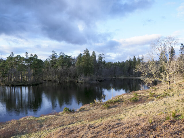
The woodland is predominantly composed of broadleaved trees, such as oak, beech, and birch. These trees create a rich and diverse habitat, supporting a wide variety of plant and animal species. The forest floor is carpeted with bluebells and other wildflowers during the spring months, creating a picturesque and vibrant scene.

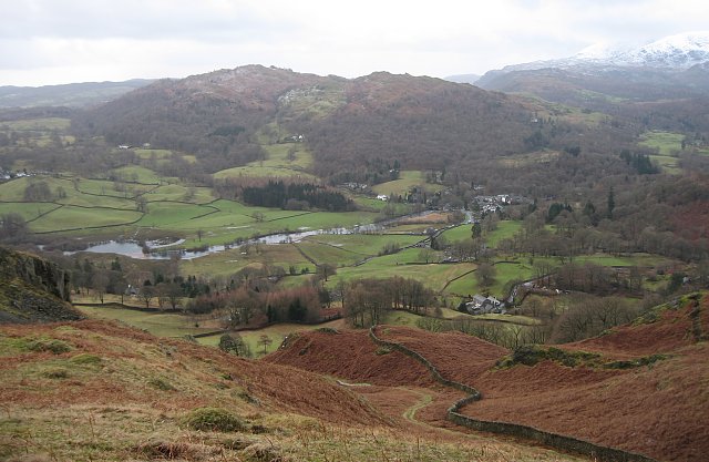
Arnside Plantation is a popular destination for nature lovers and outdoor enthusiasts. It offers a network of well-maintained walking trails that allow visitors to explore the woodland and enjoy its natural beauty. These paths wind through the trees, providing opportunities for birdwatching and wildlife spotting.

The plantation also offers recreational facilities, including picnic areas and a children's play area. These amenities make it an ideal spot for family outings and gatherings. Additionally, the woodland has a designated camping area, allowing visitors to spend the night under the stars and immerse themselves in the tranquility of the forest.

Overall, Arnside Plantation is a cherished natural resource in Lancashire, providing both recreational opportunities and a valuable habitat for wildlife. Its lush woodland, diverse plant life, and scenic trails make it a must-visit destination for anyone seeking a peaceful escape in nature.

If you have any feedback on the listing, please let us know in the comments section below.

Arnside Plantation Images

Images are sourced within 2km of 54.40676/-3.0198296 or Grid Reference NY3301. Thanks to Geograph Open Source API. All images are credited.

Newly laid hedge
Newly laid hedge
Road junction ahead
Road junction ahead
Wall, field and a view of Langdale
Eastern side of Tarn Hows Tarn Hows is an archetypal Lake District location close to the village of Coniston. It's partly an artificial creation, the result of damming one of three tarns to create a larger feature.
Eastern side of Tarn Hows
Tarn Hows is an archetypal Lake District location close to the village of Coniston. It's partly an artificial creation, the result of damming one of three tarns to create a larger feature.
Looking down on Tarn Hows An interesting comparison with Peter Trimming's May 2013 image  <a href="https://www.geograph.org.uk/photo/3477734">SD3399 : A Quiet day at Tarn Hows</a> but taken in winter 40 years earlier.
Looking down on Tarn Hows
An interesting comparison with Peter Trimming's May 2013 image SD3399 : A Quiet day at Tarn Hows but taken in winter 40 years earlier.
Rose Castle Cottage A holiday let owned by National Trust just above Tarn Hows.
Rose Castle Cottage
A holiday let owned by National Trust just above Tarn Hows.
A Frozen Tarn Hows
A Frozen Tarn Hows
Tarn Hows From the southern perimeter path.
Tarn Hows
From the southern perimeter path.
View From the Byway near Knipe Fold There was still mist in the valley below when I took this picture at 07h30.
View From the Byway near Knipe Fold
There was still mist in the valley below when I took this picture at 07h30.
Tarn Hows - Circular Island Taken from the path to the southeast of Tarn Hows looking down onto this small, roughly circular island in the middle of the tarn. The land to the left of the central island is a peninsula, while on the right can be seen the edge of another, larger island. I can't find any names for these islands on any maps.
Tarn Hows - Circular Island
Taken from the path to the southeast of Tarn Hows looking down onto this small, roughly circular island in the middle of the tarn. The land to the left of the central island is a peninsula, while on the right can be seen the edge of another, larger island. I can't find any names for these islands on any maps.
The Tarns Looking north-east from the southern part of the round-the-lake path. This mountain ash was loaded with berries.
The Tarns
Looking north-east from the southern part of the round-the-lake path. This mountain ash was loaded with berries.
Evening at Tarn Hows Peaceful evening view on the south shore of Tarn Hows, with a wooded promontory on the left and an island on the right
Evening at Tarn Hows
Peaceful evening view on the south shore of Tarn Hows, with a wooded promontory on the left and an island on the right
Tarn Hows
Tarn Hows
Rose Castle A national trust property, presumably holiday accommodation
Rose Castle
A national trust property, presumably holiday accommodation
Track junction near Rose Castle
Tarn Hows Or more precisely "The Tarns" as they were known before mans attempt at landscaping
Tarn Hows
Or more precisely "The Tarns" as they were known before mans attempt at landscaping
Tarn Hows
Tarn Hows
The National Trust's 'Rose Castle' holiday home
Show me another place!

Arnside Plantation is located at Grid Ref: NY3301 (Lat: 54.40676, Lng: -3.0198296)

Administrative County: Cumbria

District: South Lakeland

Police Authority: Cumbria

What 3 Words

///slips.trending.knees. Near Ambleside, Cumbria

Related Wikis

Black Fell (Lake District)

Black Fell is a fell in the English Lake District. It rises to the north of Tarn Hows, between Coniston and Hawkshead. == Topography == Black Fell is the...

Skelwith

Skelwith is a civil parish in South Lakeland, Cumbria, England, which includes the village of Skelwith Bridge. In the 2001 census the parish had a population...

Brathay

Brathay is a parish in Cumbria, England. Brathay Hall and the surrounding estate belong to a charity, Brathay Trust. == See also == Listed buildings in...

Skelwith Bridge

Skelwith Bridge is a small village in the southern area of the Lake District in Cumbria, England. Historically, Skelwith Bridge is part of Westmorland...

Yew Tree Tarn

Yew Tree Tarn is a small lake in the English Lake District situated in between the towns of Ambleside and Coniston. The tarn was formed when the local...

Elter Water

Elter Water is a small lake in the Lake District in North West England, half a mile southeast of the village of the same name. It has a length of 0.62...

Holme Fell

Holme Fell or Holm Fell is a fell in the Lake District in Cumbria, England. It is located between Coniston Water and Little Langdale, almost isolated from...

Lakes, Cumbria

Lakes is a civil parish in the Westmorland and Furness district, in the ceremonial county of Cumbria, England. In the 2001 census the parish had a population...

Nearby Amenities

Located within 500m of 54.40676,-3.0198296
Black Fell
Ele: 323
Natural: peak
Source: npe
Wikidata: Q4920755
Wikipedia: en:Black Fell (Lake District)
Lat/Long: 54.405491/-3.0178932
Black Fell
Is In Country Code: GB
Is In County: Cumbria
Is In Region: Lake District
Natural: fell
Source: npe
Lat/Long: 54.4098661/-3.0169821
Man Made: cairn
Lat/Long: 54.4046331/-3.0187214
Barrier: stile
Lat/Long: 54.4056384/-3.0179213
Ele: 308
Natural: peak
Source: survey
Lat/Long: 54.404548/-3.0168173
Arnside Plantation
Place: locality
Lat/Long: 54.4044299/-3.0216599
Great Cobble
Place: locality
Lat/Long: 54.4086262/-3.0166173
High Arnside
Description: OS trig pillar
Ele: 322.3
Man Made: survey_point
Note: Accurate location import for imagery offset calibration. Please do not move.
Ref: S5334
Source: Ordnance Survey (OGL)
Survey Point: pillar
Lat/Long: 54.4054932/-3.0179429
The data included in this document is from www.openstreetmap.org. The data is made available under ODbL.

Have you been to Arnside Plantation?

Leave your review of Arnside Plantation below (or comments, questions and feedback).