Clodock

Settlement in Herefordshire

England

Clodock

Cwmcoched; lower slope of Hatterrall Hill The end of the metalled road is not much further up from here.
Cwmcoched; lower slope of Hatterrall Hill Credit: Jonathan Billinger

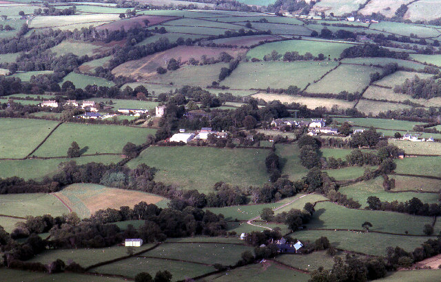
Clodock is a small village located in the county of Herefordshire, England. Situated in the scenic Golden Valley, it is nestled amidst rolling hills and picturesque countryside. The village is part of the larger parish of Longtown and is approximately 3 miles southwest of the town of Longtown.

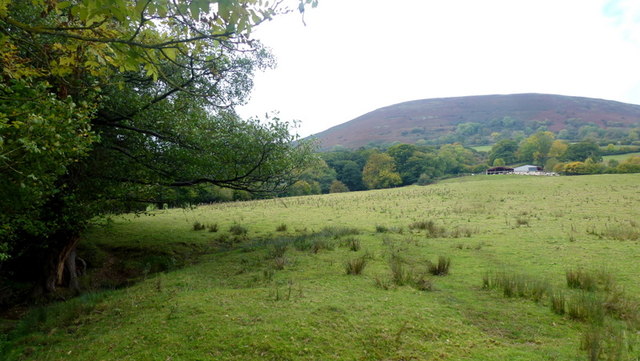
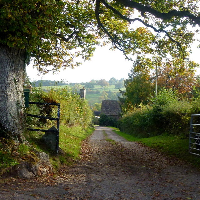
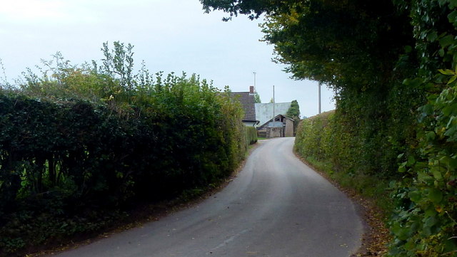
Clodock is renowned for its tranquil and idyllic setting, attracting visitors with its unspoiled natural beauty. The village is surrounded by vast expanses of farmland, dotted with charming cottages and traditional farmhouses. The River Monnow meanders through the area, adding to the picturesque charm.

At the heart of Clodock lies the historic St. Clydog's Church, a Grade II listed building with origins dating back to the Norman era. The church features an impressive 14th-century tower and is known for its beautiful stained-glass windows and intricate architecture. It serves as a focal point for the local community and hosts regular religious services and community events.

Clodock offers a range of outdoor activities for nature enthusiasts, including walking, hiking, and cycling. The surrounding countryside provides numerous trails and paths that showcase the stunning landscapes and panoramic views. The village is also in close proximity to the Black Mountains, a popular destination for hikers and climbers.

Despite its small size, Clodock boasts a vibrant community spirit, with locals actively involved in organizing events and festivals throughout the year. The village pub, The Old Castle Inn, is a hub for social gatherings and serves as a meeting place for residents and visitors alike.

In summary, Clodock is a charming and picturesque village in Herefordshire, offering a peaceful escape for those seeking a taste of rural England's beauty and tranquility.

If you have any feedback on the listing, please let us know in the comments section below.

Clodock Images

Images are sourced within 2km of 51.941918/-2.9819646 or Grid Reference SO3227. Thanks to Geograph Open Source API. All images are credited.

Cwmcoched; lower slope of Hatterrall Hill The end of the metalled road is not much further up from here.
Cwmcoched; lower slope of Hatterrall Hill
The end of the metalled road is not much further up from here.
Lower Cwmcoched The Welsh border with Herefordshire follows the woodland edge to the left.
The farm tucked below the bulk of Hatterrall Hill is in England.
Lower Cwmcoched
The Welsh border with Herefordshire follows the woodland edge to the left. The farm tucked below the bulk of Hatterrall Hill is in England.
The Grove farm entrance Guarded by a fine specimen oak tree.
The Grove farm entrance
Guarded by a fine specimen oak tree.
View from The Grove, 1 Looking south-west over Longtown towards the Hatterrall Ridge in hazy October sunshine.
View from The Grove, 1
Looking south-west over Longtown towards the Hatterrall Ridge in hazy October sunshine.
View from The Grove, 2 Sheep in lush October pasture with a backdrop of trees turning colour.
View from The Grove, 2
Sheep in lush October pasture with a backdrop of trees turning colour.
Road passing the Post Office, Longtown, Herefs The road is leaving Longtown and passing the village's Post Office on the right.
Road passing the Post Office, Longtown, Herefs
The road is leaving Longtown and passing the village's Post Office on the right.
Hopes of Longtown (1), The Farmers Barn, Longtown, Herefs On the edge of Longtown, this is a family run village shop and post office.

<a href="https://www.geograph.org.uk/photo/4718009">SO3228 : Hopes of Longtown (2), The Farmers Barn, Longtown, Herefs</a>.
Hopes of Longtown (1), The Farmers Barn, Longtown, Herefs
On the edge of Longtown, this is a family run village shop and post office. SO3228 : Hopes of Longtown (2), The Farmers Barn, Longtown, Herefs.
Hopes of Longtown (2), The Farmers Barn, Longtown, Herefs Family run village shop with post office. The postbox can also be seen here:- <a href="https://www.geograph.org.uk/photo/4718028">SO3228 : Elizabeth II postbox by Post Office, Longtown, Herefs</a>.

<a href="https://www.geograph.org.uk/photo/4717996">SO3228 : Hopes of Longtown (1), The Farmers Barn, Longtown, Herefs</a>.
Hopes of Longtown (2), The Farmers Barn, Longtown, Herefs
Elizabeth II postbox by Post Office, Longtown, Herefs The postbox is adjacent to the car park for Hopes of Longtown's village store, which includes a post office.  It can also be seen here:- <a href="https://www.geograph.org.uk/photo/4718009">SO3228 : Hopes of Longtown (2), The Farmers Barn, Longtown, Herefs</a>.

Postbox:- HR2 135. Postcode:- HR2 0LT.  Last collection:- 3.30 p.m. Monday to Friday; 9.30 a.m. Saturday.
Elizabeth II postbox by Post Office, Longtown, Herefs
The postbox is adjacent to the car park for Hopes of Longtown's village store, which includes a post office. It can also be seen here:- SO3228 : Hopes of Longtown (2), The Farmers Barn, Longtown, Herefs. Postbox:- HR2 135. Postcode:- HR2 0LT. Last collection:- 3.30 p.m. Monday to Friday; 9.30 a.m. Saturday.
Road approaching The Crown, Longtown, Herefs The Crown public house can be seen ahead on the right.
Road approaching The Crown, Longtown, Herefs
The Crown public house can be seen ahead on the right.
Longtown Village Hall (1), High Street, Longtown, Herefs The hall is used for Parish Council meetings and by various local groups. It can be hired for functions and seats up to 150 people. This view is from the hall's car park.

<a href="https://www.geograph.org.uk/photo/4718555">SO3228 : Longtown Village Hall (2),High Street,  Longtown, Herefs</a>.
Longtown Village Hall (1), High Street, Longtown, Herefs
The hall is used for Parish Council meetings and by various local groups. It can be hired for functions and seats up to 150 people. This view is from the hall's car park. SO3228 : Longtown Village Hall (2),High Street, Longtown, Herefs.
Longtown Village Hall (2),High Street,  Longtown, Herefs Another view:- <a href="https://www.geograph.org.uk/photo/4718528">SO3228 : Longtown Village Hall (1), High Street, Longtown, Herefs</a>.
Longtown Village Hall (2),High Street, Longtown, Herefs
High Street passing Longtown Village Hall, Longtown, Herefs The Village Hall is the building on the left.

<a href="https://www.geograph.org.uk/photo/4718528">SO3228 : Longtown Village Hall (1), High Street, Longtown, Herefs</a>.
High Street passing Longtown Village Hall, Longtown, Herefs
The Village Hall is the building on the left. SO3228 : Longtown Village Hall (1), High Street, Longtown, Herefs.
High Street at Longtown, Herefs Behind the wall on the right is the car park for Longtown Village Hall. The green poster is advertising a bingo session in the hall being held later in the day the photograph was taken.
High Street at Longtown, Herefs
Behind the wall on the right is the car park for Longtown Village Hall. The green poster is advertising a bingo session in the hall being held later in the day the photograph was taken.
The Crown (1), Longtown, Herefs The Crown or Crown Inn dates from 1751, but had some alterations carried out in the late 19th century and in the 20th century. It is family run and a Grade II listed building. It was once one of seven public houses, including cider houses, in the village and for many years was owned by West Country Breweries Limited. It became a free house in 1988. Behind it can be seen the Black Mountains.

<a href="https://www.geograph.org.uk/photo/4718656">SO3228 : The Crown (2) - sign, Longtown, Herefs</a>.
The Crown (1), Longtown, Herefs
The Crown or Crown Inn dates from 1751, but had some alterations carried out in the late 19th century and in the 20th century. It is family run and a Grade II listed building. It was once one of seven public houses, including cider houses, in the village and for many years was owned by West Country Breweries Limited. It became a free house in 1988. Behind it can be seen the Black Mountains. SO3228 : The Crown (2) - sign, Longtown, Herefs.
The Crown (2) - sign, Longtown, Herefs The Crown public house is also known as The Crown Inn.

Using the name The Crown indicated loyalty to the reigning monarch, which in the past was always a wise thing to do. The name has been used for inns or pubs for hundreds of years. In the past, when most people were illiterate, the sign was easily recognised by people. The Crown is almost as popular as a pub name as the Red Lion.

<a href="https://www.geograph.org.uk/photo/4718630">SO3228 : The Crown (1), Longtown, Herefs</a>.
The Crown (2) - sign, Longtown, Herefs
The Crown public house is also known as The Crown Inn. Using the name The Crown indicated loyalty to the reigning monarch, which in the past was always a wise thing to do. The name has been used for inns or pubs for hundreds of years. In the past, when most people were illiterate, the sign was easily recognised by people. The Crown is almost as popular as a pub name as the Red Lion. SO3228 : The Crown (1), Longtown, Herefs.
Public road above Cwmcoched Looking downhill, towards Longtown and Clodoch.
Public road above Cwmcoched
Looking downhill, towards Longtown and Clodoch.
Lane entering Wales Unusually a road from England enters Wales from the north, the first property is Glandwr.
Lane entering Wales
Unusually a road from England enters Wales from the north, the first property is Glandwr.
Show me another place!

Clodock is located at Grid Ref: SO3227 (Lat: 51.941918, Lng: -2.9819646)

Unitary Authority: County of Herefordshire

Police Authority: West Mercia

What 3 Words

///bottled.emailed.petrified. Near Longtown, Herefordshire

Nearby Locations

Clodock

Related Wikis

Clodock

Clodock Welsh: Clydog is a village in the west of Herefordshire, England. It lies on the River Monnow in the foothills of the Black Mountains, close to...

Longtown, Herefordshire

Longtown is a linear village and parish in Herefordshire, England. The parish includes the village of Clodock and had a population in mid-2010 of 543...
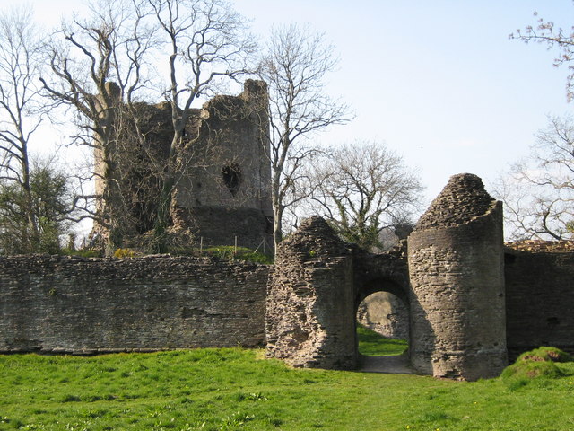
Longtown Castle

Longtown Castle, also termed Ewias Lacey Castle in early accounts, is a ruined Norman motte-and-bailey fortification in Longtown, Herefordshire. It was...

Hatterrall Hill

Hatterrall Hill (Welsh: Mynydd Y Gader) is a rounded peak in the Black Mountains which sits on the Wales-England border, partly in Monmouthshire, Wales...

Nearby Amenities

Located within 500m of 51.941918,-2.9819646
Barrier: stile
Foot: yes
Lat/Long: 51.9417672/-2.9829501
Barrier: stile
Foot: yes
Lat/Long: 51.9425497/-2.9842523
Barrier: stile
Foot: yes
Lat/Long: 51.9425952/-2.9852389
Barrier: stile
Foot: yes
Lat/Long: 51.9434284/-2.9863876
Barrier: stile
Foot: yes
Lat/Long: 51.9410643/-2.9814769
Barrier: stile
Foot: yes
Lat/Long: 51.9393393/-2.9826785
Barrier: stile
Foot: yes
Lat/Long: 51.93847/-2.9844603
Bus Stop
Church
Naptan AtcoCode: 2090A084700
Naptan Bearing: N
Naptan BusStopType: CUS
Naptan CommonName: Church
Naptan Indicator: opp
Naptan Landmark: Church. Jc Hunthouse Lane
Naptan NaptanCode: heradjpj
Naptan Street: N/K
Naptan Verified: no
Source: naptan_import
Lat/Long: 51.9419963/-2.9820249
Bus Stop
Church
Naptan AtcoCode: 2090A19077
Naptan Bearing: S
Naptan BusStopType: CUS
Naptan CommonName: Church
Naptan Indicator: adj
Naptan Landmark: N/K
Naptan NaptanCode: herajpgw
Naptan Street: N/K
Naptan Verified: no
Source: naptan_import
Lat/Long: 51.9419955/-2.9818466
Barrier: stile
Lat/Long: 51.9417497/-2.980618
Clodock
Name Cy: Merthyr Clydog
Place: village
Source: OS_OpenData_StreetView
Wikidata: Q5134858
Lat/Long: 51.9416461/-2.9819624
Post Box
Post Box Type: wall
Ref: HR2 127
Royal Cypher: EIIR
Royal Cypher Wikidata: Q33102113
Lat/Long: 51.9418261/-2.981823
Waterway: weir
Lat/Long: 51.9419032/-2.9805197
Barrier: stile
Lat/Long: 51.942053/-2.9808312
Barrier: stile
Lat/Long: 51.9430061/-2.9810634
Barrier: stile
Lat/Long: 51.9436589/-2.9810839
Barrier: stile
Lat/Long: 51.9450334/-2.9801018
Barrier: stile
Lat/Long: 51.9460844/-2.9799341
Building: yes
Lat/Long: 51.9394658/-2.9857682
Historic: memorial
Memorial: war_memorial
Lat/Long: 51.9423/-2.9817928
Generator Method: photovoltaic
Generator Output Electricity: yes
Generator Source: solar
Generator Type: solar_photovoltaic_panel
Location: roof
Power: generator
Lat/Long: 51.941755/-2.9819432
The data included in this document is from www.openstreetmap.org. The data is made available under ODbL.

Have you been to Clodock?

Leave your review of Clodock below (or comments, questions and feedback).