Hongrass Wood

Wood, Forest in Shropshire

England

Hongrass Wood

Small quarry Informal quarries such as this used to provide all the local requirements for stone. It is interesting to see that this one has been worked recently to a limited extent. The rock here is a sandstone with overlying shales of the Cefn Einion Formation, of undecided late Silurian to early Devonian age - the uncertainty arising from a non-existent or sparse set of fossils used for dating. The only thing we could find was some burrowing preserved on the level bedding surfaces. See <a href="https://www.geograph.org.uk/photo/421631">SO2886 : Cefn Einion</a> for another locality.
Small quarry Credit: Jonathan Wilkins

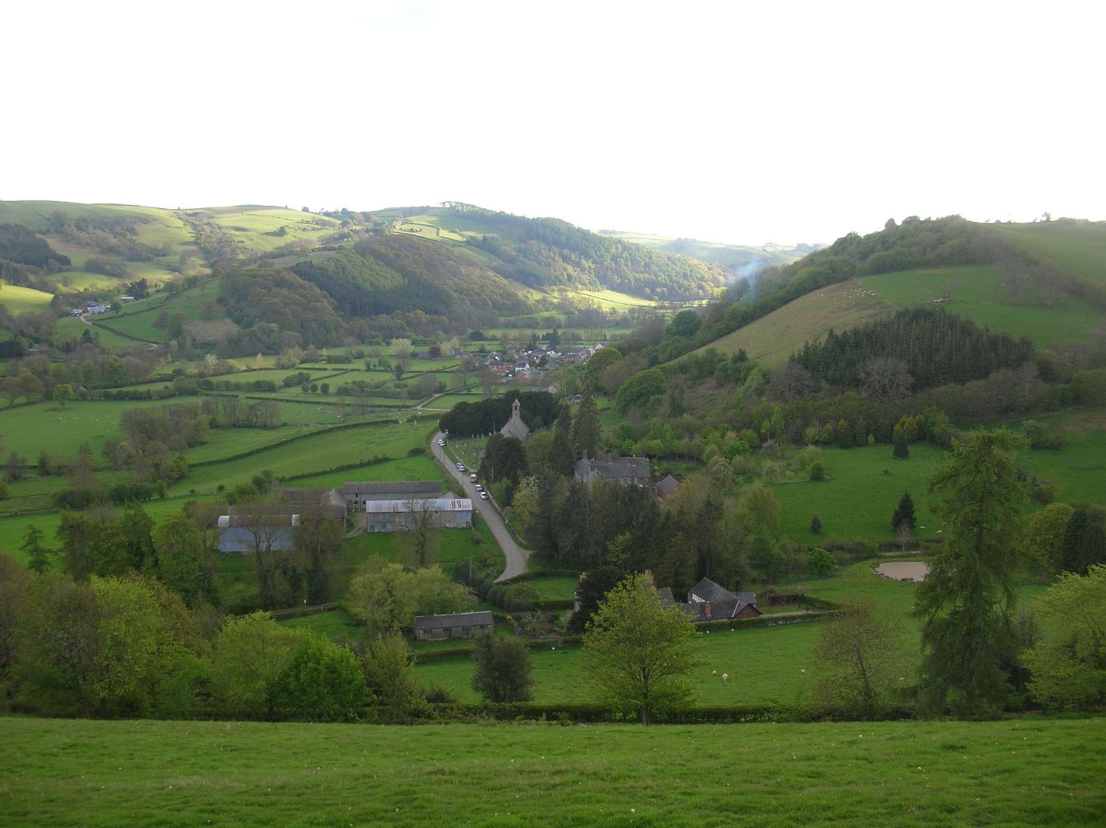
Hongrass Wood is a charming forest located in Shropshire, a county in the West Midlands region of England. It covers an area of approximately 100 hectares and is renowned for its natural beauty and diverse wildlife.

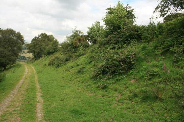
The wood features a mix of deciduous and coniferous trees, including oak, birch, beech, and pine, which create a vibrant and picturesque landscape throughout the year. The canopy formed by these trees provides a sheltered and tranquil environment, making it a popular destination for nature enthusiasts, hikers, and birdwatchers.

The forest floor is adorned with an array of wildflowers, such as bluebells, primroses, and wood anemones, which add splashes of color to the woodland. It is also home to a variety of wildlife, including deer, foxes, badgers, and a wide range of bird species, making it a haven for animal lovers and photographers.

Hongrass Wood offers a network of well-maintained walking trails, allowing visitors to explore the forest at their own pace. These trails cater to different abilities, with options for easy strolls as well as more challenging hikes. Interpretive signs and information boards are strategically placed along the trails, providing educational insights into the woodland ecosystem, local history, and the importance of conservation.

The wood is managed by the local authorities, who prioritize its preservation and protection. Visitors are encouraged to respect the environment by adhering to designated paths, refraining from littering, and not disturbing the wildlife.

Overall, Hongrass Wood is a captivating destination that offers a tranquil escape into nature, providing a delightful experience for all who visit.

If you have any feedback on the listing, please let us know in the comments section below.

Hongrass Wood Images

Images are sourced within 2km of 52.428298/-3.1139013 or Grid Reference SO2481. Thanks to Geograph Open Source API. All images are credited.

Small quarry Informal quarries such as this used to provide all the local requirements for stone. It is interesting to see that this one has been worked recently to a limited extent. The rock here is a sandstone with overlying shales of the Cefn Einion Formation, of undecided late Silurian to early Devonian age - the uncertainty arising from a non-existent or sparse set of fossils used for dating. The only thing we could find was some burrowing preserved on the level bedding surfaces. See <a href="https://www.geograph.org.uk/photo/421631">SO2886 : Cefn Einion</a> for another locality.
Small quarry
Informal quarries such as this used to provide all the local requirements for stone. It is interesting to see that this one has been worked recently to a limited extent. The rock here is a sandstone with overlying shales of the Cefn Einion Formation, of undecided late Silurian to early Devonian age - the uncertainty arising from a non-existent or sparse set of fossils used for dating. The only thing we could find was some burrowing preserved on the level bedding surfaces. See SO2886 : Cefn Einion for another locality.
Church of St John the Evangelist, Newcastle
Revolving lychgate, Newcastle The unusual revolving lychgate at the Church of St John the Evangelist, Newcastle.
Revolving lychgate, Newcastle
The unusual revolving lychgate at the Church of St John the Evangelist, Newcastle.
Farm on Church Road, Newcastle This farm appears disused and there is no name on the map.
Farm on Church Road, Newcastle
This farm appears disused and there is no name on the map.
Offa's Dyke path near Newcastle
The Clun Valley from Offa's Dyke The Church of St John the Evangelist can be seen on the right and Newcastle is just beyond the trees.
The Clun Valley from Offa's Dyke
The Church of St John the Evangelist can be seen on the right and Newcastle is just beyond the trees.
The River Clun near Newcastle The River Clun runs through the small town of Clun, as well as Newcastle-on-Clun and other villages. It meets the River Teme at Leintwardine, Herefordshire. The source of the River Clun is between the hamlet of Anchor and Bettws Hill Wood, very close to the Welsh border. The Clun Valley is very rural and is part of the Shropshire Hills AONB (Area of Outstanding Natural Beauty). 
The river gives its name to many places in the area (including Clun itself and villages such as Aston on Clun). The small River Unk flows into the Clun near Clun Castle.
The River Clun near Newcastle
The River Clun runs through the small town of Clun, as well as Newcastle-on-Clun and other villages. It meets the River Teme at Leintwardine, Herefordshire. The source of the River Clun is between the hamlet of Anchor and Bettws Hill Wood, very close to the Welsh border. The Clun Valley is very rural and is part of the Shropshire Hills AONB (Area of Outstanding Natural Beauty). The river gives its name to many places in the area (including Clun itself and villages such as Aston on Clun). The small River Unk flows into the Clun near Clun Castle.
Offa's Dyke near Newcastle Offa's Dyke (Welsh: Clawdd Offa) is a massive linear earthwork, roughly following some of the current border between England and Wales. In places, it is up to 65 feet (19.8 m) wide (including its flanking ditch) and 8 feet (2.44 m) high. In the 8th century it formed some kind of delineation between the Anglian kingdom of Mercia and the Welsh kingdom of Powys. Research in recent decades has dispelled many of the earlier theories and ideas about the earthwork.
Offa's Dyke near Newcastle
Offa's Dyke (Welsh: Clawdd Offa) is a massive linear earthwork, roughly following some of the current border between England and Wales. In places, it is up to 65 feet (19.8 m) wide (including its flanking ditch) and 8 feet (2.44 m) high. In the 8th century it formed some kind of delineation between the Anglian kingdom of Mercia and the Welsh kingdom of Powys. Research in recent decades has dispelled many of the earlier theories and ideas about the earthwork.
Offa's Dyke Path at Lower Spoad
The village of Newcastle from Offa's Dyke Path Newcastle is a village in the rural south west of Shropshire, England. It lies at the confluence of the River Clun and the Folly Brook, 3 miles west of the small town of Clun. The B4368 runs through the village, on its way between Craven Arms in Shropshire to Newtown in Powys. The village has a community hall, a campsite (Clun Valley Camping), a church and a pub (the "Crown").
The village of Newcastle from Offa's Dyke Path
Newcastle is a village in the rural south west of Shropshire, England. It lies at the confluence of the River Clun and the Folly Brook, 3 miles west of the small town of Clun. The B4368 runs through the village, on its way between Craven Arms in Shropshire to Newtown in Powys. The village has a community hall, a campsite (Clun Valley Camping), a church and a pub (the "Crown").
Offa's Dyke near Newcastle Offa's Dyke (Welsh: Clawdd Offa) is a massive linear earthwork, roughly following some of the current border between England and Wales. In places, it is up to 65 feet (19.8 m) wide (including its flanking ditch) and 8 feet (2.44 m) high. In the 8th century it formed some kind of delineation between the Anglian kingdom of Mercia and the Welsh kingdom of Powys. Research in recent decades has dispelled many of the earlier theories and ideas about the earthwork.
Offa's Dyke near Newcastle
Offa's Dyke (Welsh: Clawdd Offa) is a massive linear earthwork, roughly following some of the current border between England and Wales. In places, it is up to 65 feet (19.8 m) wide (including its flanking ditch) and 8 feet (2.44 m) high. In the 8th century it formed some kind of delineation between the Anglian kingdom of Mercia and the Welsh kingdom of Powys. Research in recent decades has dispelled many of the earlier theories and ideas about the earthwork.
Offa's Dyke Offa's Dyke (Welsh: Clawdd Offa) is a massive linear earthwork, roughly following some of the current border between England and Wales. In places, it is up to 65 feet (19.8 m) wide (including its flanking ditch) and 8 feet (2.44 m) high. In the 8th century it formed some kind of delineation between the Anglian kingdom of Mercia and the Welsh kingdom of Powys. Research in recent decades has dispelled many of the earlier theories and ideas about the earthwork.
Offa's Dyke
Offa's Dyke (Welsh: Clawdd Offa) is a massive linear earthwork, roughly following some of the current border between England and Wales. In places, it is up to 65 feet (19.8 m) wide (including its flanking ditch) and 8 feet (2.44 m) high. In the 8th century it formed some kind of delineation between the Anglian kingdom of Mercia and the Welsh kingdom of Powys. Research in recent decades has dispelled many of the earlier theories and ideas about the earthwork.
Offa's Dyke Path Offa's Dyke (Welsh: Clawdd Offa) is a massive linear earthwork, roughly following some of the current border between England and Wales. In places, it is up to 65 feet (19.8 m) wide (including its flanking ditch) and 8 feet (2.44 m) high. In the 8th century it formed some kind of delineation between the Anglian kingdom of Mercia and the Welsh kingdom of Powys. Research in recent decades has dispelled many of the earlier theories and ideas about the earthwork.
Offa's Dyke Path
Offa's Dyke (Welsh: Clawdd Offa) is a massive linear earthwork, roughly following some of the current border between England and Wales. In places, it is up to 65 feet (19.8 m) wide (including its flanking ditch) and 8 feet (2.44 m) high. In the 8th century it formed some kind of delineation between the Anglian kingdom of Mercia and the Welsh kingdom of Powys. Research in recent decades has dispelled many of the earlier theories and ideas about the earthwork.
Offa's Dyke Path near Spoad Hill Offa's Dyke Path (Welsh: Llwybr Clawdd Offa) is a long distance footpath along the Welsh-English border. Opened in 1971, it is one of Britain's premier National Trails and draws walkers from throughout the world. Much of the 283 km (177 miles) long route either follows, or keeps close company with, the remnants of Offa's Dyke, an 8th century earthwork, the majority of which was probably constructed on the orders of Mercian King Offa.
Offa's Dyke Path near Spoad Hill
Offa's Dyke Path (Welsh: Llwybr Clawdd Offa) is a long distance footpath along the Welsh-English border. Opened in 1971, it is one of Britain's premier National Trails and draws walkers from throughout the world. Much of the 283 km (177 miles) long route either follows, or keeps close company with, the remnants of Offa's Dyke, an 8th century earthwork, the majority of which was probably constructed on the orders of Mercian King Offa.
Footpath to Stoney Pound
High Hedgerows near Stoney Pound
Overgrown footpath near Hongrass This little used path heads towards Spoad Hill.
Overgrown footpath near Hongrass
This little used path heads towards Spoad Hill.
The B4368 near Newcastle The B4368 as it leaves Newcastle and heads towards Clun.
The B4368 near Newcastle
The B4368 as it leaves Newcastle and heads towards Clun.
Show me another place!

Hongrass Wood is located at Grid Ref: SO2481 (Lat: 52.428298, Lng: -3.1139013)

Unitary Authority: Shropshire

Police Authority: West Mercia

What 3 Words

///packing.refuses.september. Near Mainstone, Shropshire

Nearby Locations

Hongrass Wood

Related Wikis

Newcastle, Shropshire

Newcastle is a village in the rural south west of Shropshire, England. It lies at the confluence of the River Clun and the Folly Brook, 3 miles west of...

Ale Oak

Ale Oak is a hamlet in Shropshire, England. == External links == Media related to Ale Oak at Wikimedia Commons

Whitcott Keysett

Whitcott Keysett is a hamlet in South Shropshire, England. It is located two miles northwest of the small town of Clun. The western half of the settlement...

Mardu

Mardu is a small dispersed village in Shropshire, England. It is located a mile northwest of the village of Whitcott Keysett. The nearest town is Clun...

Have you been to Hongrass Wood?

Leave your review of Hongrass Wood below (or comments, questions and feedback).