Cubbins Green

Wood, Forest in Cheshire

England

Cubbins Green

Footpath Around West Kirby Marine Lake
Footpath Around West Kirby Marine Lake Credit: Richard Cooke

Cubbins Green is a charming woodland area located in the county of Cheshire, England. Situated within the larger district of Wood, the green is a small but picturesque forest that offers a peaceful escape from the hustle and bustle of nearby towns and cities.

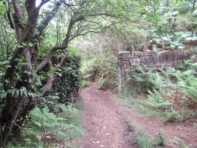
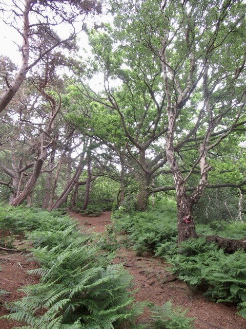
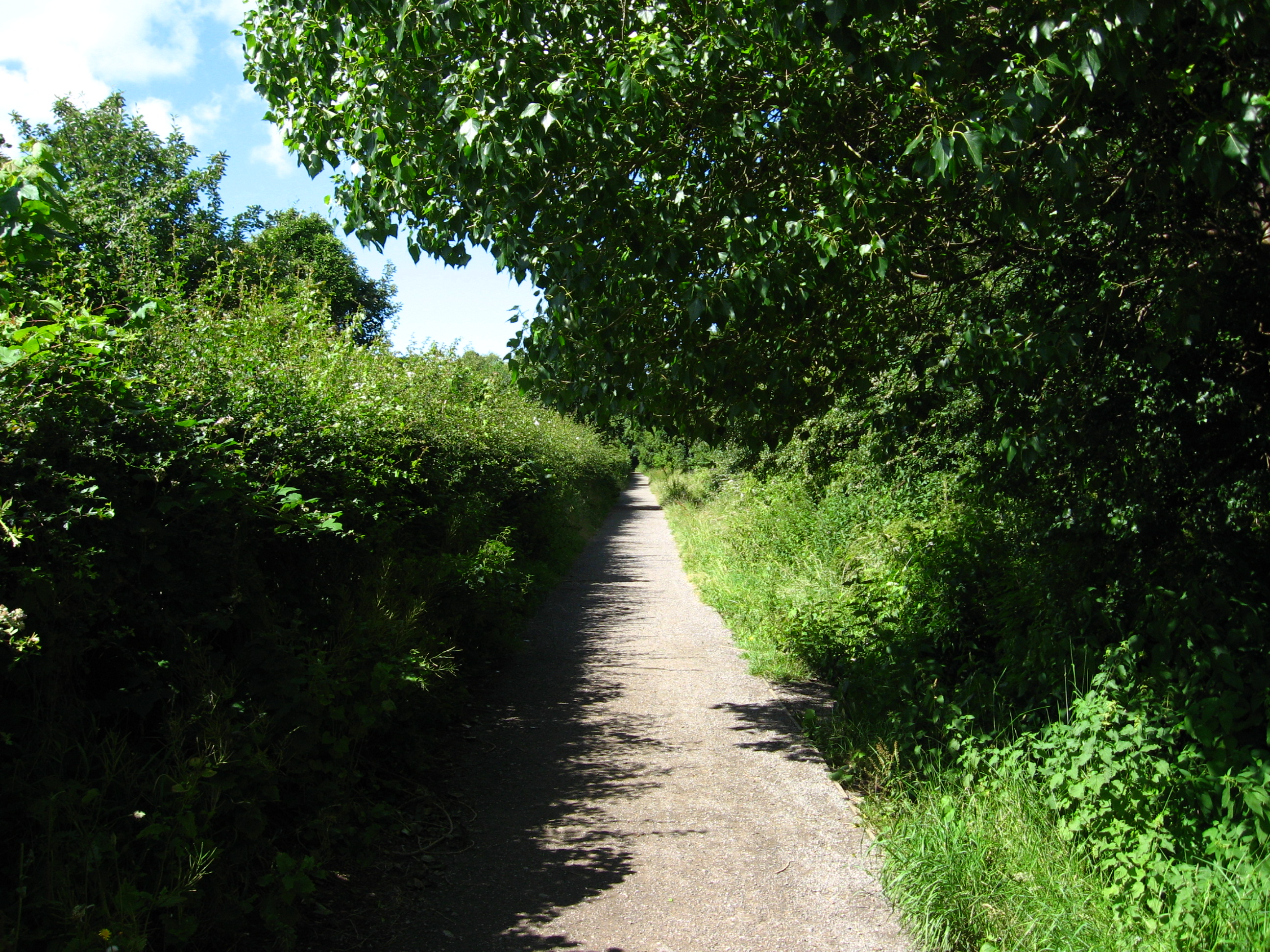
Covering an area of approximately 20 acres, Cubbins Green is characterized by its dense woodland and lush greenery. The forest is predominantly made up of a variety of deciduous trees such as oak, beech, and ash, which create a diverse and vibrant ecosystem. These trees provide a habitat for a range of wildlife, including birds, squirrels, and foxes, making the green a haven for nature enthusiasts and wildlife lovers alike.

The green is crisscrossed by a network of well-maintained footpaths, allowing visitors to explore the area at their leisure. These paths wind through the forest, taking visitors on a journey through the tranquil surroundings and providing opportunities to spot the local flora and fauna. The green is also home to a small stream, which adds to its natural beauty and provides a serene setting for picnics or quiet contemplation.

Cubbins Green is a popular destination for outdoor activities such as walking, jogging, and birdwatching. The peaceful ambiance and stunning scenery make it an ideal spot for those seeking a break from the urban environment. Its location within close proximity to Wood and other nearby villages also means that amenities such as cafes and shops are easily accessible, ensuring visitors have everything they need for a pleasant day out in nature.

If you have any feedback on the listing, please let us know in the comments section below.

Cubbins Green Images

Images are sourced within 2km of 53.358962/-3.1734451 or Grid Reference SJ2285. Thanks to Geograph Open Source API. All images are credited.

Footpath Around West Kirby Marine Lake
West Kirby Station – 1971 Remarkably, this excellent viewpoint of the station has not previously been used on Geograph. The station itself is much the same, but the signal box and the semaphore signals have gone, and the track layout is considerably simpler. On the left can be seen traces of the tracks which connected to the line via Neston to Hooton, which had a separate station off to the left which closed to passengers in 1956 and to freight in 1962. There were also goods yards (for both lines), now occupied by a fire station and a large public car park. The siding with a train standing on it has also been removed.
West Kirby Station – 1971
Remarkably, this excellent viewpoint of the station has not previously been used on Geograph. The station itself is much the same, but the signal box and the semaphore signals have gone, and the track layout is considerably simpler. On the left can be seen traces of the tracks which connected to the line via Neston to Hooton, which had a separate station off to the left which closed to passengers in 1956 and to freight in 1962. There were also goods yards (for both lines), now occupied by a fire station and a large public car park. The siding with a train standing on it has also been removed.
Wall, Caldy Hill Woodland which avoided becoming a garden to a big house.
Wall, Caldy Hill
Woodland which avoided becoming a garden to a big house.
Woodland, Caldy Hill Typical sandstone woodland which you can find between here and Worcester.
Woodland, Caldy Hill
Typical sandstone woodland which you can find between here and Worcester.
Grange Cemetery Grange Cemetery between Lang Lane and Blackhorse Hill was opened after the First World War, the site was purchased in 1913.
Grange Cemetery
Grange Cemetery between Lang Lane and Blackhorse Hill was opened after the First World War, the site was purchased in 1913.
Ramp at Cubbin's Green to the shore Cubbin's Green is the public nature reserve between the cliff and the Wirral Way. Two sisters, Eveline and Ivy Cubbin donated the land in 1964 specifying that the  land was to be "kept open and unbuilt upon and henceforth shall be known as Cubbin Green".  More history below
<span class="nowrap"><a title="https://www.liverpool.ac.uk/~cmi/cubbins/cubbGrHist.html" rel="nofollow ugc noopener" href="https://www.liverpool.ac.uk/~cmi/cubbins/cubbGrHist.html">Link</a><img style="margin-left:2px;" alt="External link" title="External link - shift click to open in new window" src="https://s1.geograph.org.uk/img/external.png" width="10" height="10"/></span>
Ramp at Cubbin's Green to the shore
Cubbin's Green is the public nature reserve between the cliff and the Wirral Way. Two sisters, Eveline and Ivy Cubbin donated the land in 1964 specifying that the land was to be "kept open and unbuilt upon and henceforth shall be known as Cubbin Green". More history below LinkExternal link
Marine Lake and North Wales Marine Lake and over to North Wales from the site of the old baths on West Kirby promenade.
Marine Lake and North Wales
Marine Lake and over to North Wales from the site of the old baths on West Kirby promenade.
West Kirby station
West Kirby station
The Crescent, West Kirby
Installation in progress New stone benches at West Kirby
Installation in progress
New stone benches at West Kirby
Breezy day at West Kirby Marine Lake
Work in progress on West Kirby Jetty
West Kirby United Reformed Church
Path round Marine Lake, West Kirby Lake to left, sea to right not long after high tide. Wales in distance on horizon.
Path round Marine Lake, West Kirby
Lake to left, sea to right not long after high tide. Wales in distance on horizon.
St Bridget's, West Kirby A most handsome building both inside and out.
St Bridget's, West Kirby
A most handsome building both inside and out.
508104 at West Kirby A Class 508 EMU at West Kirby Station.
508104 at West Kirby
A Class 508 EMU at West Kirby Station.
Show me another place!

Cubbins Green is located at Grid Ref: SJ2285 (Lat: 53.358962, Lng: -3.1734451)

Unitary Authority: Wirral

Police Authority: Merseyside

What 3 Words

///horns.electrode.gender. Near West Kirby, Merseyside

Related Wikis

Caldy railway station

Caldy railway station was a station on the single track Hooton to West Kirby branch of the Birkenhead Railway, on the Wirral Peninsula, England. ��2�...

Church of the Resurrection and All Saints, Caldy

The Church of the Resurrection and All Saints is in the village of Caldy, Wirral, Merseyside, England. The church is recorded in the National Heritage...

Caldy

Caldy (historically spelled Calday) is a small, affluent village on the Wirral Peninsula, England, south-east of West Kirby. It is part of the West Kirby...

Kirby Park railway station

Kirby Park railway station was a station on the single track Hooton to West Kirby branch of the Birkenhead Railway, on the Wirral Peninsula, England....

Nearby Amenities

Located within 500m of 53.358962,-3.1734451
Source: PGS
Lat/Long: 53.3610802/-3.1766858
Source: PGS
Lat/Long: 53.3584651/-3.1741402
Source: PGS
Lat/Long: 53.3580222/-3.1737035
Source: PGS
Lat/Long: 53.357696/-3.1734395
Created By: almien_coastlines
Source: PGS
Lat/Long: 53.357241/-3.172939
Source: PGS
Lat/Long: 53.3564847/-3.1721336
Source: PGS
Lat/Long: 53.3561274/-3.1717849
Source: PGS
Lat/Long: 53.3549283/-3.1704949
Turning Circle
Lat/Long: 53.362092/-3.1756721
Post Box
Collection Times: Mo-Fr 09:00; Sa 07:00
Description: QE II wall mounted post box CH48 502 at the junction of Croft Drive & Shore Road, Caldy.
Operator: Royal Mail
Post Box Type: wall
Ref: CH48 502
Royal Cypher: EIIR
Royal Cypher Wikidata: Q33102113
Wikimedia Commons: File:Post box at Shore Road, Caldy.jpg
Lat/Long: 53.3556234/-3.1695235
Turning Circle
Lat/Long: 53.3627461/-3.1760664
Bus Stop
CALDY ROAD/CROFT DRIVE WEST
Bus: yes
Naptan AtcoCode: 2800S31038A
Naptan Bearing: NW
Naptan CommonName: CALDY ROAD/CROFT DRIVE WEST
Naptan Indicator: CALDY ROAD/CROFT DRIVE WEST
Naptan Landmark: CALDY ROAD/CROFT DRIVE WEST
Naptan NaptanCode: merawmjt
Naptan Notes: No Notes
Naptan ShortCommonName: Caldy Rd/Croft Dr W
Naptan Street: CALDY ROAD
Naptan Verified: no
Public Transport: platform
Source: naptan_import
Lat/Long: 53.3594792/-3.168588
Bus Stop
CALDY ROAD
Bus: yes
Naptan AtcoCode: 2800S31039A
Naptan Bearing: SE
Naptan CommonName: CALDY ROAD
Naptan Indicator: CALDY ROAD
Naptan Landmark: O/S 57
Naptan NaptanCode: mergmdtp
Naptan Notes: No Notes
Naptan ShortCommonName: Caldy Rd
Naptan Street: CALDY ROAD
Naptan Verified: no
Public Transport: platform
Source: naptan_import
Lat/Long: 53.3620935/-3.1714998
Bus Stop
CALDY ROAD
Bus: yes
Naptan AtcoCode: 2800S31039B
Naptan Bearing: NW
Naptan CommonName: CALDY ROAD
Naptan Indicator: CALDY ROAD
Naptan Landmark: O/S 52 CALLED `MAYFIELD`
Naptan NaptanCode: merawmjw
Naptan Notes: No Notes
Naptan ShortCommonName: Caldy Rd
Naptan Street: CALDY ROAD
Naptan Verified: no
Public Transport: platform
Source: naptan_import
Lat/Long: 53.3617279/-3.1712042
Post Box
Operator: Royal Mail
Operator Wikidata: Q638098
Post Box Type: lamp
Ref: CH48 63
Royal Cypher: EIIR
Royal Cypher Wikidata: Q33102113
Source Amenity: survey
Wikimedia Commons: File:Post box at Melloncroft Drive, Caldy.jpg
Lat/Long: 53.3606233/-3.1700073
Bench
Lat/Long: 53.3605066/-3.1698764
Bench
Lat/Long: 53.3606069/-3.1700143
Bench
Lat/Long: 53.3610725/-3.1671525
Bench
Lat/Long: 53.3611523/-3.1672272
Bench
Lat/Long: 53.3617854/-3.1686856
Bench
Lat/Long: 53.3615027/-3.1679048
Caldy Hill
Ele: 77
Natural: peak
Lat/Long: 53.3607967/-3.1666927
Generator Method: photovoltaic
Generator Output Electricity: yes
Generator Source: solar
Generator Type: solar_photovoltaic_panel
Location: roof
Power: generator
Lat/Long: 53.360864/-3.1738199
Generator Method: photovoltaic
Generator Output Electricity: yes
Generator Source: solar
Generator Type: solar_photovoltaic_panel
Location: roof
Power: generator
Lat/Long: 53.3615685/-3.1742909
Direction: SSW
Generator Method: photovoltaic
Generator Output Electricity: yes
Generator Solar Modules: 9
Generator Source: solar
Generator Type: solar_photovoltaic_panel
Location: roof
Power: generator
Lat/Long: 53.3624313/-3.1771003
Direction: SSW
Generator Method: photovoltaic
Generator Output Electricity: yes
Generator Solar Modules: 2
Generator Source: solar
Generator Type: solar_photovoltaic_panel
Location: roof
Power: generator
Lat/Long: 53.3624834/-3.1770989
Direction: SSW
Generator Method: photovoltaic
Generator Output Electricity: yes
Generator Solar Modules: 61158751
Generator Source: solar
Generator Type: solar_photovoltaic_panel
Location: roof
Power: generator
Lat/Long: 53.3628252/-3.1768052
Direction: WNW
Generator Method: photovoltaic
Generator Output Electricity: yes
Generator Solar Modules: 10
Generator Source: solar
Generator Type: solar_photovoltaic_panel
Location: roof
Power: generator
Lat/Long: 53.3628604/-3.1769434
Direction: WSW
Generator Method: photovoltaic
Generator Output Electricity: yes
Generator Source: solar
Generator Type: solar_photovoltaic_panel
Location: roof
Power: generator
Lat/Long: 53.362186/-3.1755225
Caldy
Historic Railway: station
Railway: site
Wikidata: Q5019182
Wikipedia: en:Caldy railway station
Lat/Long: 53.3564571/-3.170016
A local family legacy
Tourism: information
Lat/Long: 53.3587299/-3.1737769
The data included in this document is from www.openstreetmap.org. The data is made available under ODbL.

Have you been to Cubbins Green?

Leave your review of Cubbins Green below (or comments, questions and feedback).