Bank Wood

Wood, Forest in Cumberland Allerdale

England

Bank Wood

Armathwaite Hall Gateway and South Lodge The exit gate of Armathwaite Hall.  Formerly a private house, Armathwaite Hall is now a hotel.
There is an Ordnance Survey cut benchmark on the face of the right hand gatepost (detail photograph <a href="https://www.geograph.org.uk/photo/7162420">NY2032 : Benchmark, Armathwaite Hall Hotel Gate</a>).
Armathwaite Hall Gateway and South Lodge Credit: Adrian Taylor

Bank Wood is a picturesque forest located in Cumberland, a historic county in North West England. Covering an area of approximately 100 acres, it is known for its rich biodiversity and stunning natural beauty. The wood is situated on a gentle slope, which gives it its name, and is surrounded by rolling hills and meadows.

The forest is predominantly composed of deciduous trees, with oak, beech, and ash being the most common species. These towering trees provide a dense canopy that filters sunlight, creating a cool and tranquil atmosphere within the wood. The forest floor is covered in a thick layer of leaf litter, which supports a diverse range of plant life including bluebells, wild garlic, and ferns.

Bank Wood is home to a variety of wildlife, making it a popular destination for nature enthusiasts and birdwatchers. Visitors may spot a range of bird species including woodpeckers, nuthatches, and owls, as well as small mammals like squirrels, rabbits, and foxes. The wood is also known for its population of deer, which can often be glimpsed roaming through the trees.

Several footpaths and trails wind their way through the forest, offering visitors the opportunity to explore its beauty on foot. These paths lead to charming viewpoints and clearings, where visitors can take in the panoramic views of the surrounding countryside.

Bank Wood is not only a haven for wildlife and nature lovers but also provides a peaceful retreat for those seeking solace and tranquility in the heart of nature.

If you have any feedback on the listing, please let us know in the comments section below.

Bank Wood Images

Images are sourced within 2km of 54.682572/-3.214634 or Grid Reference NY2132. Thanks to Geograph Open Source API. All images are credited.

Armathwaite Hall Gateway and South Lodge The exit gate of Armathwaite Hall.  Formerly a private house, Armathwaite Hall is now a hotel.
There is an Ordnance Survey cut benchmark on the face of the right hand gatepost (detail photograph <a href="https://www.geograph.org.uk/photo/7162420">NY2032 : Benchmark, Armathwaite Hall Hotel Gate</a>).
Armathwaite Hall Gateway and South Lodge
The exit gate of Armathwaite Hall. Formerly a private house, Armathwaite Hall is now a hotel. There is an Ordnance Survey cut benchmark on the face of the right hand gatepost (detail photograph NY2032 : Benchmark, Armathwaite Hall Hotel Gate).
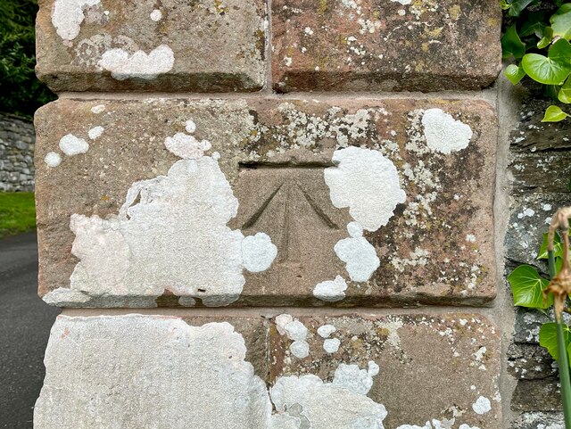
Benchmark, Armathwaite Hall Hotel Gate Detail of an Ordnance Survey cut benchmark on the pillar of the exit gate of Armathwaite Hall Hotel.  The benchmark marks a height of 87.6178m above mean sea level (Ordnance Datum Newlyn) last verified in 1969 (location photograph <a href="https://www.geograph.org.uk/photo/7162409">NY2032 : Armathwaite Hall Gateway and South Lodge</a>).
Benchmark, Armathwaite Hall Hotel Gate
Detail of an Ordnance Survey cut benchmark on the pillar of the exit gate of Armathwaite Hall Hotel. The benchmark marks a height of 87.6178m above mean sea level (Ordnance Datum Newlyn) last verified in 1969 (location photograph NY2032 : Armathwaite Hall Gateway and South Lodge).
Direction Sign – Signpost on the A591 at Kilnhill Located on the southeast side of the junction of the A591 and North Row in Kilnhill, in Bassenthwaite parish. 1 arm and pawn finial.

Milestone Society National ID: CU_NY2132
Direction Sign – Signpost on the A591 at Kilnhill
Located on the southeast side of the junction of the A591 and North Row in Kilnhill, in Bassenthwaite parish. 1 arm and pawn finial. Milestone Society National ID: CU_NY2132
Bassenthwaite Lake from Banks Point
Path through the lakeside woodland
Stone steps up to the lay-by
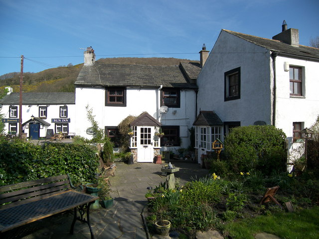
Castle Inn Hotel The Castle Inn Hotel beside the A591 road.
There is an Ordnance Survey cut benchmark on the painted stone quoin at the front corner of the building (photograph <a href="https://www.geograph.org.uk/photo/7264103">NY2132 : Benchmark, The Castle Inn Hotel</a>).
Castle Inn Hotel
The Castle Inn Hotel beside the A591 road. There is an Ordnance Survey cut benchmark on the painted stone quoin at the front corner of the building (photograph NY2132 : Benchmark, The Castle Inn Hotel).
Benchmark, The Castle Inn Hotel Detail of the Ordnance Survey cut benchmark on the south east corner of The Castle Inn Hotel.  The benchmark marks a height of 106.6495m above sea level (Ordnance Datum Newlyn) last verified in 1969 (location photograph <a href="https://www.geograph.org.uk/photo/7261411">NY2132 : Castle Inn Hotel</a>).
Benchmark, The Castle Inn Hotel
Detail of the Ordnance Survey cut benchmark on the south east corner of The Castle Inn Hotel. The benchmark marks a height of 106.6495m above sea level (Ordnance Datum Newlyn) last verified in 1969 (location photograph NY2132 : Castle Inn Hotel).
Bassenthwaite village and Skiddaw
Binsey One of the northernmost fells in the Lake District National Park and the northernmost Wainwright summit, Binsey has an altitude of 447m (1466 feet) and stands isolated from the nearby fells.
There is an Ordnance Survey trigonometrical column on the summit (photograph <a href="https://www.geograph.org.uk/photo/7583609">NY2235 : Triangulation Pillar, Binsey</a>).
Binsey
One of the northernmost fells in the Lake District National Park and the northernmost Wainwright summit, Binsey has an altitude of 447m (1466 feet) and stands isolated from the nearby fells. There is an Ordnance Survey trigonometrical column on the summit (photograph NY2235 : Triangulation Pillar, Binsey).
No Entry Armathwaite Hall Hotel operates a one way traffic system on the drives within the hotel grounds.
No Entry
Armathwaite Hall Hotel operates a one way traffic system on the drives within the hotel grounds.
Parkland near Armathwaite Hall
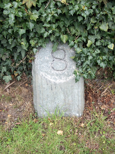
Old Milestone by the B5291, near Armathwaite Hotel Carved stone post by the B5291, in parish of BASSENTHWAITE (ALLERDALE District), exit of Armathwaite Hall, on grass verge against wall, on West side of road. Cockermouth numeral, erected by the Keswick turnpike trust in the 19th century. 

Inscription reads:-
8 
(To Keswick)

Milestone Society National ID: CU_KWCM08
Old Milestone by the B5291, near Armathwaite Hotel
Carved stone post by the B5291, in parish of BASSENTHWAITE (ALLERDALE District), exit of Armathwaite Hall, on grass verge against wall, on West side of road. Cockermouth numeral, erected by the Keswick turnpike trust in the 19th century. Inscription reads:- 8 (To Keswick) Milestone Society National ID: CU_KWCM08
Direction Sign – Signpost on the A591 at Chapel Bridge Located at Chapel Bridge on the southwest side of the crossroads of the A591 and School Road. Bassenthwaite parish. 4 arms and annulus finial. Refurbished by Terry Moore. For an earlier photo, see <a title="https://www.geograph.org.uk/photo/6048969" href="https://www.geograph.org.uk/photo/6048969">Link</a>. See also <span class="nowrap"><a title="http://www.geog.port.ac.uk/webmap/thelakes/photos/blo49.jpg" rel="nofollow ugc noopener" href="http://www.geog.port.ac.uk/webmap/thelakes/photos/blo49.jpg">Link</a><img style="margin-left:2px;" alt="External link" title="External link - shift click to open in new window" src="https://s1.geograph.org.uk/img/external.png" width="10" height="10"/></span>.

Milestone Society National ID: CU_NY2231
Direction Sign – Signpost on the A591 at Chapel Bridge
Located at Chapel Bridge on the southwest side of the crossroads of the A591 and School Road. Bassenthwaite parish. 4 arms and annulus finial. Refurbished by Terry Moore. For an earlier photo, see Link. See also LinkExternal link. Milestone Society National ID: CU_NY2231
Silage Baling near to Binsey Grass having been cut and dried (to one extent or another) and rolled into cylindrical bales is then gathered and wrapped in plastic sheeting by the clever piece of kit drawn by the tractor. Binsey is the hill in the background.
Silage Baling near to Binsey
Grass having been cut and dried (to one extent or another) and rolled into cylindrical bales is then gathered and wrapped in plastic sheeting by the clever piece of kit drawn by the tractor. Binsey is the hill in the background.
Burthwaite, near Bassenthwaite The name of both the lane and the farm. Looking westwards.
Burthwaite, near Bassenthwaite
The name of both the lane and the farm. Looking westwards.
View to Skiddaw from above Bassenthwaite
Old Milestone by the B5291, near Armathwaite Hotel Carved stone post by the B5291, in parish of BASSENTHWAITE (ALLERDALE District), exit of Armathwaite Hall, on grass verge against wall, on West side of road. Cockermouth numeral, erected by the Keswick turnpike trust in the 19th century. 

Inscription reads:-
8 
(To Keswick)

Milestone Society National ID: CU_KWCM08
Old Milestone by the B5291, near Armathwaite Hotel
Carved stone post by the B5291, in parish of BASSENTHWAITE (ALLERDALE District), exit of Armathwaite Hall, on grass verge against wall, on West side of road. Cockermouth numeral, erected by the Keswick turnpike trust in the 19th century. Inscription reads:- 8 (To Keswick) Milestone Society National ID: CU_KWCM08
Show me another place!

Bank Wood is located at Grid Ref: NY2132 (Lat: 54.682572, Lng: -3.214634)

Administrative County: Cumbria

District: Allerdale

Police Authority: Cumbria

What 3 Words

///puddings.livid.cherish. Near Cockermouth, Cumbria

Nearby Locations

Kilnhill Bank Wood

Related Wikis

Bassenfell Manor

Bassenfell Manor is a manor house in Bassenthwaite, Cumbria, overlooking Bassenthwaite Lake in England's Lake District. It is used as a Christian residential...

Armathwaite Hall

Armathwaite Hall is a luxury hotel and spa adjacent to Bassenthwaite Lake, in Cumbria. == History == The present hall dates back to circa 1500; it was...

Bassenthwaite

Bassenthwaite is a village and civil parish to the west of Bassenthwaite Lake in Cumbria, historically part of Cumberland, within the Lake District National...

St Bega's Way

St Bega's Way is a 36-mile (58 km) walk through rural West Cumbria and the north west corner of the English Lake District. It is usually completed as a...

Chapel, Cumbria

Chapel is a hamlet in the English county of Cumbria. Chapel is located on the A591 road between Bassenthwaite and Bassenthwaite Lake. The Cumbria Way crosses...

Bewaldeth and Snittlegarth

Bewaldeth and Snittlegarth is a civil parish in Cumbria, England, historically part of Cumberland. It lies north of Bassenthwaite Lake, in the Lake District...

Bassenthwaite Lake railway station

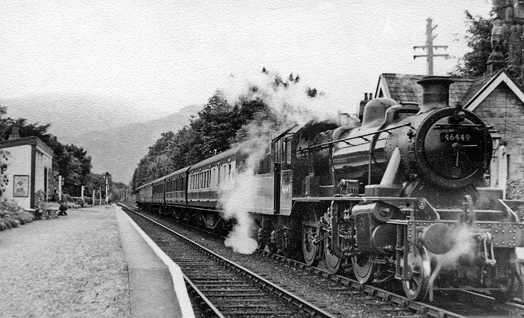
Bassenthwaite Lake railway station was situated on the Cockermouth, Keswick and Penrith Railway between Penrith and Cockermouth in Cumbria, England. The...

Dubwath

Dubwath is a hamlet in the Allerdale district, in Cumbria, England. It is part of the parish of Setmurthy. The population of this civil parish taken at...

Nearby Amenities

Located within 500m of 54.682572,-3.214634
Pub
Castle Inn Hotel
Lat/Long: 54.6834558/-3.219091
Booth: KX100
Covered: booth
Disused Amenity: telephone
Man Made: telephone_box
Lat/Long: 54.6831299/-3.2194559
Bus Stop
Castle Inn Hotel
Bench: no
Covered: no
Naptan AtcoCode: 090002050570
Naptan Bearing: W
Naptan CommonName: Castle Inn Hotel
Naptan Indicator: w/bound
Naptan Landmark: Castle Inn Hotel
Naptan NaptanCode: cumadamd
Naptan Street: B5291
Naptan Verified: yes
Shelter: no
Source: naptan_import
Lat/Long: 54.6830892/-3.2190853
Bus Stop
Castle Inn Hotel A591 N bound
Naptan AtcoCode: 090002050571
Naptan Bearing: N
Naptan CommonName: Castle Inn Hotel A591 N bound
Naptan Indicator: near
Naptan Landmark: Entrance to Castle Inn Hotel car park
Naptan NaptanCode: cumadamg
Naptan Street: A591
Naptan Verified: no
Source: naptan_import
Lat/Long: 54.6839784/-3.2191015
Bus Stop
Castle Inn A591 S bound
Bench: no
Covered: no
Local Ref: AT
Naptan AtcoCode: 090002050572
Naptan Bearing: S
Naptan CommonName: Castle Inn A591 S bound
Naptan Indicator: at
Naptan Landmark: Junction of B5291
Naptan NaptanCode: cumadapm
Naptan Street: A591
Naptan Verified: yes
Shelter: no
Source: naptan_import
Lat/Long: 54.6832998/-3.2186624
Bus Stop
Castle Inn at The Smithy (W bound)
Bench: no
Covered: no
Naptan AtcoCode: 090002050573
Naptan Bearing: W
Naptan CommonName: Castle Inn at The Smithy (W bound)
Naptan Indicator: near
Naptan Landmark: junction of A591
Naptan NaptanCode: cumadapt
Naptan Street: A591
Naptan Verified: yes
Shelter: no
Source: naptan_import
Lat/Long: 54.683169/-3.2180061
Bus Stop
Castle Inn at The Smithy
Bench: no
Covered: no
Naptan AtcoCode: 090002050574
Naptan Bearing: E
Naptan CommonName: Castle Inn at The Smithy
Naptan Indicator: Near
Naptan Landmark: Crossroads on the road to Caldbeck
Naptan NaptanCode: cumadapw
Naptan Street: B5291
Naptan Verified: yes
Shelter: no
Source: naptan_import
Lat/Long: 54.6833781/-3.2180287
Bus Stop
The Castle Inn
Bench: no
Covered: yes
Naptan AtcoCode: 090002051246
Naptan Bearing: E
Naptan CommonName: The Castle Inn
Naptan Indicator: o/s
Naptan Landmark: Castle Inn Hotel
Naptan NaptanCode: cumdmwdj
Naptan Street: B5291
Naptan Verified: yes
Shelter: yes
Source: naptan_import
Lat/Long: 54.6831361/-3.2195046
Bank Wood
Natural: wood
Source: OS OpenData StreetView
Lat/Long: 54.682248/-3.2121658
Bassenfell Manor Christian Centre
Addr City: Bassenthwaite
Addr Postcode: CA12 4RL
Phone: +44 1768 776 366
Tourism: hostel
Website: https://www.bassenfell.org.uk/
Wikidata: Q4868065
Wikipedia: en:Bassenfell Manor
Lat/Long: 54.6828899/-3.2146793
Post Box
Post Box Type: lamp
Ref: CA12 176
Royal Cypher: EIIR
Royal Cypher Wikidata: Q33102113
Lat/Long: 54.6831319/-3.2194363
Phone: +44 17687 76401
Lat/Long: 54.6837967/-3.2193496
Barrier: stile
Lat/Long: 54.6810805/-3.2181152
Bench
Lat/Long: 54.6833871/-3.2182286
South View
Addr City: Bassenthwaite
Addr Postcode: CA12 4RG
Addr Street: North Row
Guest House: bed_and_breakfast
Phone: +44 17687 76920
Tourism: guest_house
Website: https://www.southviewbassenthwaite.co.uk/
Lat/Long: 54.6817906/-3.2165368
Kiln Hill Barn
Addr City: Bassenthwaite
Addr Postcode: CA12 4RG
Guest House: bed_and_breakfast
Phone: +44 1768 776454
Tourism: guest_house
Lat/Long: 54.6815898/-3.2178963
Kiln Hill
Place: locality
Lat/Long: 54.6825295/-3.2206739
Abandoned: yes
Man Made: mineshaft
Lat/Long: 54.6814067/-3.2072584
Abandoned: yes
Man Made: mineshaft
Lat/Long: 54.6820022/-3.2091834
Power: pole
Lat/Long: 54.6791565/-3.2189539
Power: pole
Lat/Long: 54.6798016/-3.2193992
Power: pole
Lat/Long: 54.6805723/-3.2199544
Power: pole
Lat/Long: 54.6813647/-3.2205123
Power: pole
Lat/Long: 54.6820175/-3.2208905
Power: pole
Lat/Long: 54.6833045/-3.2216227
Bench
Lat/Long: 54.6824445/-3.2119994
Bench
Lat/Long: 54.6821677/-3.2083087
Bench
Lat/Long: 54.682101/-3.2082873
Power: pole
Lat/Long: 54.679666/-3.2185316
Power: pole
Lat/Long: 54.6804798/-3.2191682
Power: pole
Lat/Long: 54.6786766/-3.2177627
Power: pole
Lat/Long: 54.6869099/-3.216413
Power: pole
Lat/Long: 54.6860867/-3.2177751
Power: pole
Lat/Long: 54.685187/-3.2184799
Power: pole
Lat/Long: 54.6844546/-3.2190421
Power: pole
Lat/Long: 54.6806907/-3.2088647
Power: pole
Lat/Long: 54.6832741/-3.2081031
Power: pole
Lat/Long: 54.6822178/-3.2089319
Power: pole
Lat/Long: 54.6817566/-3.2089257
Power: pole
Lat/Long: 54.6841559/-3.2074148
The data included in this document is from www.openstreetmap.org. The data is made available under ODbL.

Have you been to Bank Wood?

Leave your review of Bank Wood below (or comments, questions and feedback).