Clifton Campville

Settlement in Staffordshire Lichfield

England

Clifton Campville

Clifton Campville from the air Clifton Campville is towards the lower left corner. Junction 11 on the M42/A42 is to the right of centre.
Clifton Campville from the air Credit: Thomas Nugent

Clifton Campville is a small village located in the county of Staffordshire, England. Situated approximately 10 miles northeast of Tamworth, it falls within the district of North West Leicestershire. With a population of around 500 inhabitants, it is a close-knit community known for its picturesque countryside and charming rural character.

The village is steeped in history, with evidence of human habitation dating back to the Roman era. The name "Clifton Campville" derives from the Old English words "clif" meaning "cliff" and "tun" meaning "settlement," indicating its location on a steep hill. The village is home to several well-preserved historical buildings, including St. Andrew's Church, a Grade I listed building that dates back to the 12th century. The church features a unique octagonal spire and beautiful stained glass windows.

Agriculture plays a significant role in the local economy, with many residents involved in farming and related industries. The village also benefits from a number of small businesses, including traditional pubs, a post office, and a village shop. Despite its small size, Clifton Campville boasts a vibrant community spirit, with various social events and activities taking place throughout the year.

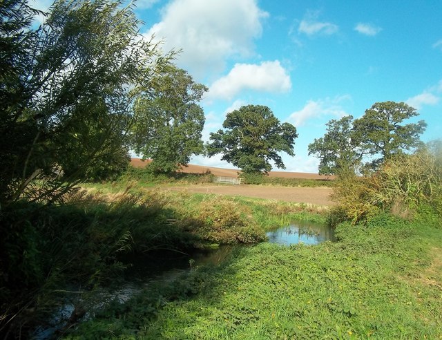
Surrounded by rolling countryside, the village offers ample opportunities for outdoor recreation. It is a popular destination for walkers and cyclists, who can explore the scenic landscapes and nearby woodlands. The National Forest, a vast woodland area, is within easy reach and provides a haven for wildlife and nature enthusiasts.

Overall, Clifton Campville is a quintessential English village, known for its historical heritage, tranquil surroundings, and close-knit community.

If you have any feedback on the listing, please let us know in the comments section below.

Clifton Campville Images

Images are sourced within 2km of 52.695452/-1.620044 or Grid Reference SK2510. Thanks to Geograph Open Source API. All images are credited.

Clifton Campville from the air Clifton Campville is towards the lower left corner. Junction 11 on the M42/A42 is to the right of centre.
Clifton Campville from the air
Clifton Campville is towards the lower left corner. Junction 11 on the M42/A42 is to the right of centre.
Entrance to Bald Hill's Farm, Lullington
The Road to Clifton Campville from Lullington
Cleat Hill Farm, Haunton This farm is a member of the Caravan Club.
Cleat Hill Farm, Haunton
This farm is a member of the Caravan Club.
Red Brick Implement Shed, Newhouse Farm, Haunton
Entering Clifton Campville from Haunton
Smith Lane / Clifton Lane Road Junction, Clifton Campville
House for Sale on the Outskirts of Clifton Campville
The River Mease near Stones Bridge River and county boundary just outside Clifton Campville. The far bank is in Staffordshire and the picture was taken in Derbyshire.
The River Mease near Stones Bridge
River and county boundary just outside Clifton Campville. The far bank is in Staffordshire and the picture was taken in Derbyshire.
The Most Southerly Point in Derbyshire This stretch of riverbank is the very southern tip of the county. It's at SK26731105 close to Clifton Campville, separated from Staffordshire by the River Mease.
The Most Southerly Point in Derbyshire
This stretch of riverbank is the very southern tip of the county. It's at SK26731105 close to Clifton Campville, separated from Staffordshire by the River Mease.
The River Mease near Seal Fields Farm 3 counties share this grid square. This picture was taken from Derbyshire with Leicestershire on the opposite bank. Further along the far bank we are over into Staffordshire.
The River Mease near Seal Fields Farm
3 counties share this grid square. This picture was taken from Derbyshire with Leicestershire on the opposite bank. Further along the far bank we are over into Staffordshire.
Mease Lane (track) Footpath heading north.
Mease Lane (track)
Footpath heading north.
Farmland off Mease Lane
Farmland, Newhouse Farm
Minor road heading east Towards Clifton Campville.
Minor road heading east
Towards Clifton Campville.
Farmland near Haunton
Farm track heading north near Haunton
Rectory Cottage, Clifton Campville
Show me another place!

Clifton Campville is located at Grid Ref: SK2510 (Lat: 52.695452, Lng: -1.620044)

Administrative County: Staffordshire

District: Lichfield

Police Authority: Staffordshire

What 3 Words

///clotting.donation.rigs. Near Donisthorpe, Leicestershire

Related Wikis

Clifton Campville

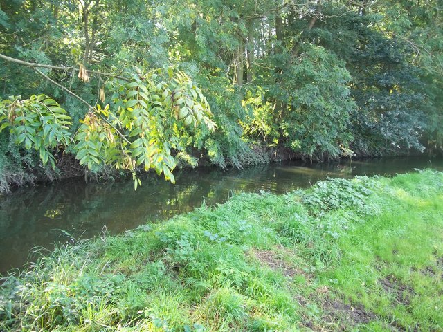
Clifton Campville is a village, former manor and civil parish in Staffordshire, England. It lies on the River Mease, about 10 miles (16 km) east of the...

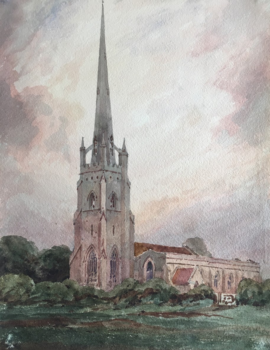
Church of St Andrew, Clifton Campville

The Church of St Andrew is a Grade I listed church in the village of Clifton Campville, Staffordshire. It was built in the 13th and 14th centuries. The...

Haunton

Haunton is a village in Staffordshire, England. It lies on the River Mease, about 7 miles (11 km) north of Tamworth, 1½ miles east of Harlaston and 1 mile...

River Mease SSSI

River Mease SSSI is a 23.0 hectares (57 acres) biological Site of Special Scientific Interest. It is a stretch of the River Mease and its tributary Gilwiskaw...

All Saints' Church, Lullington

All Saints’ Church, Lullington is a Grade II* listed parish church in the Church of England in Lullington, Derbyshire. == History == The church dates...

Thorpe Constantine

Thorpe Constantine is a small village and civil parish in Staffordshire, England. It lies about 6 miles (10 km) north-east of Tamworth and 6 miles south...

Lullington, Derbyshire

Lullington is a village and civil parish in the district of South Derbyshire in Derbyshire, England. The population of the civil parish at the 2011 Census...

Chilcote

Chilcote is a village and civil parish in the North West Leicestershire district of Leicestershire, England. Until 1897 it was in Derbyshire. The parish...

Nearby Amenities

Located within 500m of 52.695452,-1.620044
Mini Roundabout
Lat/Long: 52.6963466/-1.6255144
Clifton Campville
Is In: Staffordshire
Place: village
Wikidata: Q2344915
Lat/Long: 52.6949146/-1.625863
Bus Stop
Green Man PH
Bus: yes
Naptan AtcoCode: 3800C409001
Naptan Bearing: SE
Naptan CommonName: Green Man PH
Naptan Indicator: Adj
Naptan Landmark: Green Man PH
Naptan Street: Main Street
Naptan Verified: no
Public Transport: platform
Source: naptan_import
Lat/Long: 52.6958209/-1.6211067
Bus Stop
Green Man PH
Bus: yes
Naptan AtcoCode: 3800C409002
Naptan Bearing: NW
Naptan BusStopType: CUS
Naptan CommonName: Green Man PH
Naptan Indicator: Opp
Naptan Landmark: Green Man PH
Naptan Street: Main Street
Naptan Verified: no
Public Transport: platform
Source: naptan_import
Lat/Long: 52.6956952/-1.6211669
Pub
The Green Man
Lat/Long: 52.6961294/-1.6211783
Generator Method: photovoltaic
Generator Output Electricity: yes
Generator Source: solar
Generator Type: solar_photovoltaic_panel
Location: roof
Power: generator
Lat/Long: 52.6951967/-1.622589
Generator Method: photovoltaic
Generator Output Electricity: yes
Generator Source: solar
Generator Type: solar_photovoltaic_panel
Location: roof
Power: generator
Lat/Long: 52.6961428/-1.6241125
Generator Method: photovoltaic
Generator Output Electricity: yes
Generator Source: solar
Generator Type: solar_photovoltaic_panel
Location: roof
Power: generator
Lat/Long: 52.6967247/-1.6249842
Generator Method: photovoltaic
Generator Output Electricity: yes
Generator Source: solar
Generator Type: solar_photovoltaic_panel
Location: roof
Power: generator
Lat/Long: 52.6953481/-1.6204575
Generator Method: photovoltaic
Generator Output Electricity: yes
Generator Source: solar
Generator Type: solar_photovoltaic_panel
Location: roof
Power: generator
Lat/Long: 52.6945174/-1.6210476
Generator Method: photovoltaic
Generator Output Electricity: yes
Generator Source: solar
Generator Type: solar_photovoltaic_panel
Location: roof
Power: generator
Lat/Long: 52.6940996/-1.6217476
Defibrillator
Booth: K6
Covered: booth
Defibrillator Location: inside red phone box, Main Street, Clifton Cmpville
Emergency: defibrillator
Man Made: telephone_box
Old Phone: +44 1827 373220
Lat/Long: 52.6960217/-1.6226344
The data included in this document is from www.openstreetmap.org. The data is made available under ODbL.

Have you been to Clifton Campville?

Leave your review of Clifton Campville below (or comments, questions and feedback).