Courtmoor Covert

Wood, Forest in Devon East Devon

England

Courtmoor Covert

Old Bridge Marker near Upottery Bridge County Bridge Marker on the west side of the road and 97 metres northwest of Upottery Bridge, River Otter. Upottery parish. Inscribed C to mark the extent of roadway adjoining the bridge that the County was obliged to maintain.

Milestone Society National ID: DV_HNTA07br
Old Bridge Marker near Upottery Bridge Credit: T Jenkinson

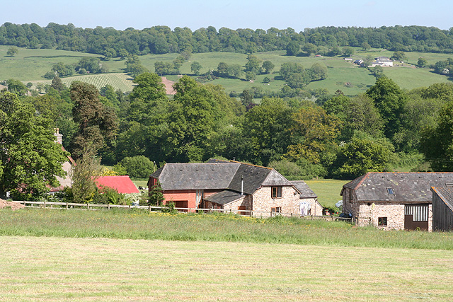
Courtmoor Covert is a picturesque woodland located in the county of Devon, England. Covering an area of approximately 50 acres, it is situated in the heart of the beautiful countryside, surrounded by rolling hills and meandering streams. Courtmoor Covert is known for its diverse range of tree species, including oak, beech, birch, and pine, which create a stunning canopy of greenery.

The woodland is a haven for wildlife, providing a valuable habitat for many species. Visitors to Courtmoor Covert may spot a variety of birds, such as woodpeckers, owls, and thrushes, as well as small mammals like rabbits, squirrels, and hedgehogs. The tranquil atmosphere and abundance of flora and fauna make it a popular spot for nature enthusiasts, birdwatchers, and photographers.

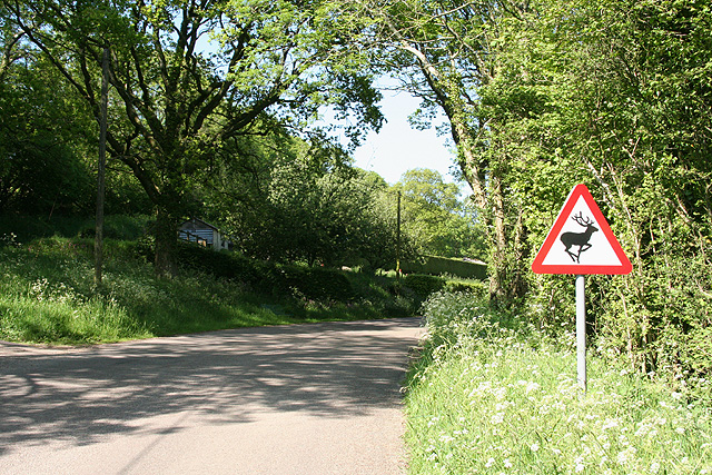
There are several walking trails that wind their way through Courtmoor Covert, allowing visitors to explore the woodland at their own pace. These well-maintained paths offer a chance to immerse oneself in nature, away from the hustle and bustle of everyday life. Along the trails, visitors will come across informative signage that provides interesting facts about the woodland's ecology and history.

Courtmoor Covert is also a designated site of special scientific interest (SSSI) due to its rich biodiversity and geological importance. It is managed by the local conservation authority, which ensures the preservation of the woodland's natural beauty and the protection of its wildlife.

Whether for a peaceful stroll, birdwatching, or simply reconnecting with nature, Courtmoor Covert offers a tranquil and serene escape from the modern world, providing visitors with a true taste of Devon's natural beauty.

If you have any feedback on the listing, please let us know in the comments section below.

Courtmoor Covert Images

Images are sourced within 2km of 50.85608/-3.122774 or Grid Reference ST2106. Thanks to Geograph Open Source API. All images are credited.

Old Bridge Marker near Upottery Bridge County Bridge Marker on the west side of the road and 97 metres northwest of Upottery Bridge, River Otter. Upottery parish. Inscribed C to mark the extent of roadway adjoining the bridge that the County was obliged to maintain.

Milestone Society National ID: DV_HNTA07br
Old Bridge Marker near Upottery Bridge
County Bridge Marker on the west side of the road and 97 metres northwest of Upottery Bridge, River Otter. Upottery parish. Inscribed C to mark the extent of roadway adjoining the bridge that the County was obliged to maintain. Milestone Society National ID: DV_HNTA07br
The Sidmouth Arms pub, in Upottery
Church of St. Mary the Virgin
Entering Rawridge in low afternoon light
Otter Vale Close, Rawridge
Lane junction north of Rawridge
Glebe Farm buildings near Upottery
The Sidmouth Arms Pub in Upottery A view of the front of the Sidmouth Arms Pub in Upottery, Devon as viewed from the road that runs through the village.
The Sidmouth Arms Pub in Upottery
A view of the front of the Sidmouth Arms Pub in Upottery, Devon as viewed from the road that runs through the village.
Upottery: overlooking Glebe Farm Barns converted to residences. Looking south east
Upottery: overlooking Glebe Farm
Barns converted to residences. Looking south east
Luppitt: towards Rawridge Looking east-south-east on a humid June afternoon
Luppitt: towards Rawridge
Looking east-south-east on a humid June afternoon
Middle fish pond View of middle pond, looking towards Rawridge, with the A303 on the far ridge.
Middle fish pond
View of middle pond, looking towards Rawridge, with the A303 on the far ridge.
Upottery: by a turning to Beacon Hill Looking north east. Wild deer are quite common in this neck of the woods
Upottery: by a turning to Beacon Hill
Looking north east. Wild deer are quite common in this neck of the woods
Upottery: Sidmouth Arms An inn offering bed and breakfast. Looking north-north-east
Upottery: Sidmouth Arms
An inn offering bed and breakfast. Looking north-north-east
Upottery: Robins Cottage Looking north east across the graveyard of Upottery church, dedicated to St Mary the Virgin, to which the cottage abuts
Upottery: Robins Cottage
Looking north east across the graveyard of Upottery church, dedicated to St Mary the Virgin, to which the cottage abuts
Upottery: cottages at Rawridge Looking north east. The minor road on the right leads to Rawridge Farm and the A30 Trunk Road. The building nearest the camera is Willow Cottage
Upottery: cottages at Rawridge
Looking north east. The minor road on the right leads to Rawridge Farm and the A30 Trunk Road. The building nearest the camera is Willow Cottage
Upottery: fountain at Rawridge ‘This fountain is erected in lasting memory of my husband, Gerald, 4th Viscount Sidmouth. The welfare of his tenants was his constant thought and his last care was to give them this supply of pure water. He died on March 25th 1915.’ Looking south east
Upottery: fountain at Rawridge
‘This fountain is erected in lasting memory of my husband, Gerald, 4th Viscount Sidmouth. The welfare of his tenants was his constant thought and his last care was to give them this supply of pure water. He died on March 25th 1915.’ Looking south east
Upottery: the River Otter Just downstream from Upottery Bridge. Looking south west
Upottery: the River Otter
Just downstream from Upottery Bridge. Looking south west
Stockland: lane near Hillgrounds Looking south-south-east
Stockland: lane near Hillgrounds
Looking south-south-east
Show me another place!

Courtmoor Covert is located at Grid Ref: ST2106 (Lat: 50.85608, Lng: -3.122774)

Administrative County: Devon

District: East Devon

Police Authority: Devon and Cornwall

What 3 Words

///deed.overpaid.belief. Near Dunkeswell, Devon

Nearby Locations

Courtmoor Covert

Related Wikis

Upottery

Upottery (originally Up Ottery) is a rural village, civil parish and former manor in East Devon, England. == Location == Upottery takes up both sides of...

Mohuns Ottery

Mohuns Ottery or Mohun's Ottery ( "moon's awtrey"), is a house and historic manor in the parish of Luppitt, 1 mile south-east of the village of Luppitt...

Hartridge Hill

Hartridge Hill is an elongated, peat hill situated in the Luppitt catchment area of East Devon, England. Mostly privately owned and primarily used for...

Yarcombe

Yarcombe is a village and civil parish in the county of Devon, England, situated in the East Devon administrative district on the A30 road near the towns...

Nearby Amenities

Located within 500m of 50.85608,-3.122774
Power: pole
Source: bing
Lat/Long: 50.8557781/-3.128715
Power: pole
Source: bing
Lat/Long: 50.855481/-3.1278916
Power: pole
Source: bing
Transformer: distribution
Lat/Long: 50.8551567/-3.126985
Power: pole
Source: bing
Lat/Long: 50.8575771/-3.1287861
Power: pole
Source: bing
Lat/Long: 50.8585388/-3.1246126
Power: pole
Source: bing
Lat/Long: 50.857865/-3.127571
Power: pole
Source: bing
Lat/Long: 50.8582171/-3.1260771
Power: pole
Source: bing
Lat/Long: 50.8588622/-3.1231266
Power: pole
Source: bing
Lat/Long: 50.8591339/-3.1221879
Power: pole
Source: bing
Lat/Long: 50.8594133/-3.1210104
Power: pole
Source: bing
Transformer: distribution
Lat/Long: 50.8596859/-3.1198664
Power: pole
Source: bing
Lat/Long: 50.8596927/-3.1192736
The data included in this document is from www.openstreetmap.org. The data is made available under ODbL.

Have you been to Courtmoor Covert?

Leave your review of Courtmoor Covert below (or comments, questions and feedback).