Branland Copse
Wood, Forest in Somerset Somerset West and Taunton
England
Branland Copse
Branland Copse is a picturesque wood located in Somerset, England. Covering an area of approximately 50 acres, it is a haven for nature lovers and those seeking tranquility amidst the beauty of the countryside. The copse is situated in the foothills of the Quantock Hills, offering stunning views of rolling hills and valleys.
The woodland is predominantly composed of native broadleaf trees, including oak, beech, and ash, which create a dense canopy overhead, providing shade and shelter for a diverse range of flora and fauna. The forest floor is carpeted with a variety of wildflowers, such as bluebells and primroses, adding a burst of color to the landscape during the springtime.
Several walking trails wind their way through Branland Copse, allowing visitors to explore its natural wonders at their own pace. These paths lead visitors through ancient woodlands and along bubbling brooks, providing the perfect opportunity for birdwatching or simply enjoying the peaceful ambiance of the forest.
Branland Copse is also home to a rich array of wildlife, including deer, badgers, and a variety of bird species. Birdwatchers may spot woodpeckers, nuthatches, and even the elusive tawny owl in the canopy above. The copse offers a valuable habitat for these creatures, as well as a sanctuary for rare and endangered species.
Overall, Branland Copse is a captivating woodland that offers a delightful escape from the hustle and bustle of everyday life. Its natural beauty, diverse wildlife, and serene atmosphere make it a popular destination for nature enthusiasts and those seeking a peaceful retreat in the heart of Somerset.
If you have any feedback on the listing, please let us know in the comments section below.
Branland Copse Images
Images are sourced within 2km of 51.205876/-3.1353547 or Grid Reference ST2045. Thanks to Geograph Open Source API. All images are credited.


Branland Copse is located at Grid Ref: ST2045 (Lat: 51.205876, Lng: -3.1353547)
Administrative County: Somerset
District: Somerset West and Taunton
Police Authority: Avon and Somerset
What 3 Words
///notices.decimals.passions. Near Nether Stowey, Somerset
Nearby Locations
Related Wikis

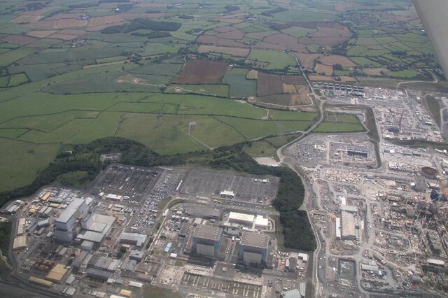
Hinkley Point A nuclear power station
Hinkley Point A nuclear power station is a former Magnox nuclear power station. It is located on a 19.4-hectare (48-acre) site in Somerset on the Bristol...

Hinkley Point
Hinkley Point is a headland on the Bristol Channel coast of Somerset, England, 5 miles (8 kilometres) north of Bridgwater and 5 mi (8 km) west of Burnham...

Hinkley Point C nuclear power station
Hinkley Point C nuclear power station (HPC) is a two-unit, 3,200 MWe EPR nuclear power station under construction in Somerset, England.The site was one...
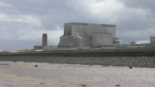
Hinkley Point B nuclear power station
Hinkley Point B nuclear power station was a nuclear power station near Bridgwater, Somerset, on the Bristol Channel coast of south west England. It was...

Stogursey
Stogursey is a small village and civil parish in the Quantock Hills in Somerset, England. It is situated 3 miles (4.8 km) from Nether Stowey, and 8 miles...

Stogursey Priory
Stogursey Priory, also called Stoke Courcy Priory or The Priory of St Andrew de Stoke, was a Benedictine alien priory dedicated to St Andrew at Stogursey...

Stogursey Castle
Stogursey Castle is a medieval castle in Somerset, England. Most of the site is in ruins, but there is a thatched gatehouse used for holiday rental by...
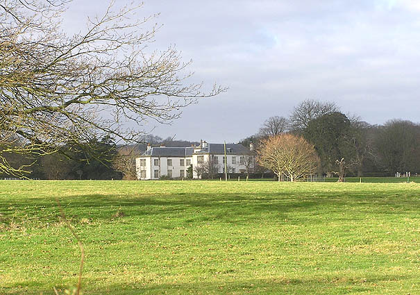
Fairfield, Stogursey
Fairfield House is a historic house in Stogursey, Somerset, England. A house existed on the site from the 12th century and it has been owned by the same...
Nearby Amenities
Located within 500m of 51.205876,-3.1353547Have you been to Branland Copse?
Leave your review of Branland Copse below (or comments, questions and feedback).