Buckman Brow Wood

Wood, Forest in Cumberland Copeland

England

Buckman Brow Wood

A595 at Buckman Brow
A595 at Buckman Brow Credit: Colin Pyle

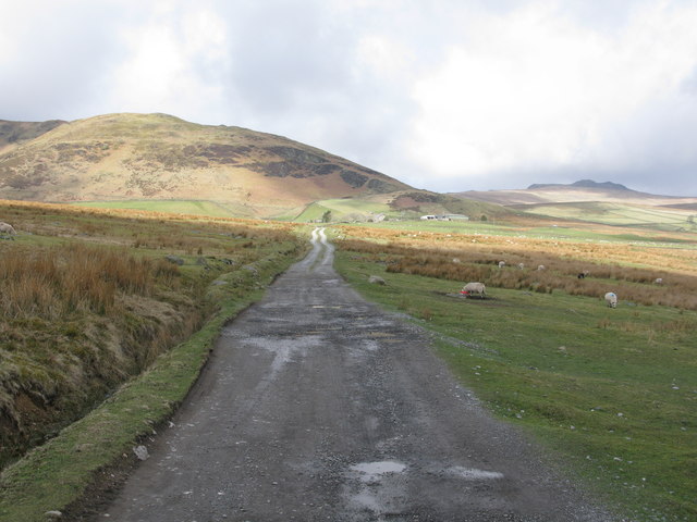
Buckman Brow Wood is a picturesque forest located in Cumberland, England. Covering an area of approximately 200 acres, this woodland is renowned for its natural beauty and diverse flora and fauna. The wood is situated on a gently sloping hillside, offering visitors stunning views of the surrounding countryside.

The forest is primarily composed of mixed deciduous trees, including oak, beech, and ash, creating a vibrant and colorful landscape throughout the year. The dense canopy provides a haven for a wide variety of wildlife, making Buckman Brow Wood a popular destination for nature enthusiasts and birdwatchers.

Walking trails wind their way through the wood, allowing visitors to explore its enchanting corners. The paths are well-maintained and offer a peaceful and tranquil experience, with the sound of birdsong and the rustling of leaves as the only background noise.

Visitors to Buckman Brow Wood may be lucky enough to spot some of the woodland's inhabitants, which include deer, badgers, foxes, and a wide array of bird species. The forest is particularly known for its populations of tawny owls, woodpeckers, and various small songbirds.

The wood is open to the public year-round and is a popular spot for picnicking, photography, and simply immersing oneself in the beauty of nature. It is also an important site for conservation efforts, with ongoing initiatives to protect and preserve its unique ecosystem.

In conclusion, Buckman Brow Wood is a captivating woodland in Cumberland, offering visitors a chance to escape the hustle and bustle of everyday life and immerse themselves in the tranquility of nature.

If you have any feedback on the listing, please let us know in the comments section below.

Buckman Brow Wood Images

Images are sourced within 2km of 54.274921/-3.2394538 or Grid Reference SD1987. Thanks to Geograph Open Source API. All images are credited.

A595 at Buckman Brow
Recent felling on Coops Wood has opened up a view of the bridge over the Duddon
Ordnance Survey Cut Mark This OS cut mark can be found adjacent to the letter box at Broadgate. It marks a point 107.274m above mean sea level.
Ordnance Survey Cut Mark
This OS cut mark can be found adjacent to the letter box at Broadgate. It marks a point 107.274m above mean sea level.
Ordnance Survey Cut Mark This OS cut mark can be found on a large rock to the west of the track.
Ordnance Survey Cut Mark
This OS cut mark can be found on a large rock to the west of the track.
Bluebells, Furnace Wood In deepest Duddon
Bluebells, Furnace Wood
In deepest Duddon
Dry Tarn, Barrow The drought has dried up this tiny tarn. I suspect it is the same as <a href="https://www.geograph.org.uk/photo/3741119">SD1888 : Small tarn on Barrow</a>
Dry Tarn, Barrow
The drought has dried up this tiny tarn. I suspect it is the same as SD1888 : Small tarn on Barrow
Ascending Barrow Looking towards the Duddon estuary
Ascending Barrow
Looking towards the Duddon estuary
On Barrow A rarely frequented top
On Barrow
A rarely frequented top
On Barrow Looks like the top
On Barrow
Looks like the top
Duddon iron furnace (disused) A charcoal burning blast furnace dating from 1736. Isaac Wilkinson's cylinder bellows powered by water were first applied here. It is a Scheduled Ancient Monument but is temporarily closed to the public while structural issues are considered. There is a good view from the bridleway that goes past the site.
Duddon iron furnace (disused)
A charcoal burning blast furnace dating from 1736. Isaac Wilkinson's cylinder bellows powered by water were first applied here. It is a Scheduled Ancient Monument but is temporarily closed to the public while structural issues are considered. There is a good view from the bridleway that goes past the site.
Pivot type mark This Pivot style mark can be found on the SE parapet of the bridge.
Pivot type mark
This Pivot style mark can be found on the SE parapet of the bridge.
Start of the track to the Swinside Stone Circle The track branching off to the left leads to the Stone Circle and Swinside Farm.
Start of the track to the Swinside Stone Circle
The track branching off to the left leads to the Stone Circle and Swinside Farm.
Track to the Swinside Stone Circle A rough track which also leads to Swinside Farm. Swinside Fell is in the background.
Track to the Swinside Stone Circle
A rough track which also leads to Swinside Farm. Swinside Fell is in the background.
SRPS Cumbrian Coast Railtour 2018 : Signal Post Before Duddon Viaduct
SRPS Cumbrian Coast Railtour 2018 : Approaching Duddon Viaduct
Ordnance Survey Flush Bracket (G3075) This OS Flush Bracket can be found on a roadside building at Duddon Bridge Farm. It marks a point 10.398m above mean sea level.
Ordnance Survey Flush Bracket (G3075)
This OS Flush Bracket can be found on a roadside building at Duddon Bridge Farm. It marks a point 10.398m above mean sea level.
Ordnance Survey Cut Mark This OS cut mark can be found on a rock face west side of the road. It marks a point 31.425m above mean sea level.
Ordnance Survey Cut Mark
This OS cut mark can be found on a rock face west side of the road. It marks a point 31.425m above mean sea level.
Ordnance Survey Cut Mark This OS cut mark can be found on the large boulder in the wall SE side of the road. It marks a point 99.048m above mean sea level.
Ordnance Survey Cut Mark
This OS cut mark can be found on the large boulder in the wall SE side of the road. It marks a point 99.048m above mean sea level.
Show me another place!

Buckman Brow Wood is located at Grid Ref: SD1987 (Lat: 54.274921, Lng: -3.2394538)

Administrative County: Cumbria

District: Copeland

Police Authority: Cumbria

What 3 Words

///crawled.contemplate.hacking. Near Millom, Cumbria

Related Wikis

Duddon Bridge

Duddon Bridge is a hamlet in Cumbria, England. == References ==

Duddon furnace

The Duddon furnace (Grid Reference SD 197883) is a surviving charcoal-fuelled blast furnace near Broughton-in-Furness in Cumbria. It is on the west side...

Bank End

Bank End is a village in Cumbria, England. == External links == Media related to Bank End, South Lakeland at Wikimedia Commons

St Mary Magdalene's Church, Broughton-in-Furness

St Mary Magdalene's Church is in Broughton-in-Furness, Cumbria, England. It is an active Anglican parish church in the deanery of Furness, the archdeaconry...

Broughton-in-Furness

Broughton in Furness is a market town in the civil parish of Broughton West in the Westmorland and Furness district of Cumbria, England. It had a population...

Broughton-in-Furness railway station

Broughton-in-Furness railway station served the market town of Broughton-in-Furness, in Lancashire, England (now in Cumbria). It was on the branch line...

Eccle Riggs

Eccle Riggs is a country house located on Eccle Riggs, a ridge of land about 0.75 miles (1.2 km) to the south of Broughton-in-Furness, Cumbria, England...

Foxfield railway station

Foxfield is a railway station on the Cumbrian Coast Line, which runs between Carlisle and Barrow-in-Furness. The station, situated 11+1⁄2 miles (19 km...

Nearby Amenities

Located within 500m of 54.274921,-3.2394538
Barrier: stile
Lat/Long: 54.2755965/-3.2436943
Barrier: stile
Lat/Long: 54.275162/-3.2451497
Barrier: cattle_grid
Lat/Long: 54.2722542/-3.2398603
Material: wood
Power: pole
Lat/Long: 54.2737342/-3.2357459
Material: wood
Power: pole
Lat/Long: 54.2744703/-3.235027
Material: wood
Power: pole
Lat/Long: 54.275197/-3.2343082
Material: wood
Power: pole
Lat/Long: 54.2760396/-3.2334606
Power: pole
Lat/Long: 54.2768101/-3.2327579
Material: wood
Power: pole
Lat/Long: 54.2751688/-3.2348768
Parking
Parking: street_side
Lat/Long: 54.2783651/-3.2368316
Ash House
Place: locality
Lat/Long: 54.275143/-3.246237
Holme
Place: locality
Lat/Long: 54.2754782/-3.2355033
Abandoned: yes
Man Made: mineshaft
Lat/Long: 54.2789695/-3.238382
The Mount
Ele: 151
Natural: peak
Lat/Long: 54.2740248/-3.2424974
Power: pole
Lat/Long: 54.2708958/-3.2373525
Power: pole
Lat/Long: 54.2712476/-3.2374403
Power: pole
Lat/Long: 54.2715972/-3.2375087
Power: pole
Lat/Long: 54.2719828/-3.237579
Power: pole
Lat/Long: 54.2706589/-3.2402763
Power: pole
Lat/Long: 54.2708661/-3.2395879
Power: pole
Lat/Long: 54.2712876/-3.238299
Power: pole
Lat/Long: 54.2755898/-3.2469687
Power: pole
Lat/Long: 54.2761804/-3.2464817
Power: pole
Lat/Long: 54.2769268/-3.2458495
Power: pole
Lat/Long: 54.2776915/-3.245178
Power: pole
Lat/Long: 54.2751537/-3.2466901
Power: pole
Lat/Long: 54.2729316/-3.2366118
The data included in this document is from www.openstreetmap.org. The data is made available under ODbL.

Have you been to Buckman Brow Wood?

Leave your review of Buckman Brow Wood below (or comments, questions and feedback).