Clint's Wood

Wood, Forest in Cumberland Allerdale

England

Clint's Wood

Walking a snow-covered road The individual is walking west along a road south of Cockermouth. Light snow began to fall in the morning following the passing overnight of Storm Arwen, and was still falling as the image was made.
Walking a snow-covered road Credit: Trevor Littlewood

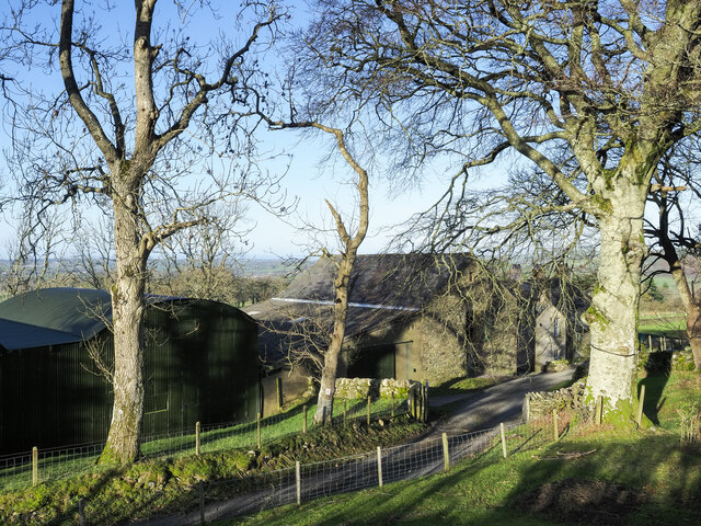
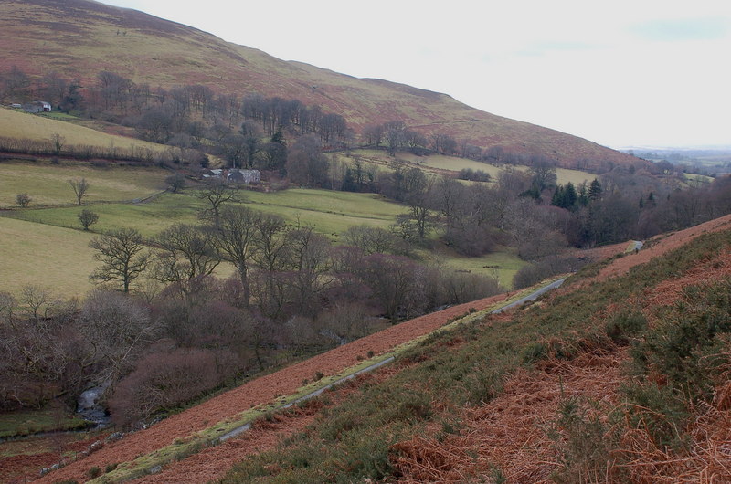
Clint's Wood, located in Cumberland, is a stunning example of a dense and ancient forest. Spread over a vast area, this woodland is a haven for nature enthusiasts and a vital ecosystem in the region. The wood is named after its previous owner, Clint, who dedicated his life to the preservation and conservation of this natural treasure.

Covered in a variety of deciduous and coniferous trees, Clint's Wood is a spectacle of colors throughout the year. In the spring, the forest floor is adorned with vibrant wildflowers, while in the autumn, the trees transform into a dazzling array of reds, oranges, and yellows. The wood is home to a plethora of plant and animal species, including oak, beech, pine, and birch trees, as well as deer, foxes, squirrels, and numerous bird species.

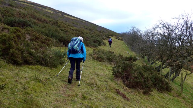
The wood is crisscrossed with a network of well-maintained trails, allowing visitors to explore its beauty at their own pace. These trails offer breathtaking views of the surrounding landscape and provide opportunities for hiking, birdwatching, and photography. Clint's Wood also features picnic areas and designated camping spots, making it a perfect destination for a day trip or a weekend getaway.

The management of Clint's Wood is dedicated to the preservation of its natural heritage and the education of visitors about the importance of conservation. Regular guided tours and educational programs are organized to raise awareness about the fragile ecosystem and to promote responsible outdoor activities.

Overall, Clint's Wood is a majestic forest that offers a serene escape from the hustle and bustle of daily life. Its stunning beauty, diverse flora and fauna, and commitment to conservation make it a must-visit destination for nature lovers and adventurers alike.

If you have any feedback on the listing, please let us know in the comments section below.

Clint's Wood Images

Images are sourced within 2km of 54.636015/-3.3121563 or Grid Reference NY1527. Thanks to Geograph Open Source API. All images are credited.

Walking a snow-covered road The individual is walking west along a road south of Cockermouth. Light snow began to fall in the morning following the passing overnight of Storm Arwen, and was still falling as the image was made.
Walking a snow-covered road
The individual is walking west along a road south of Cockermouth. Light snow began to fall in the morning following the passing overnight of Storm Arwen, and was still falling as the image was made.
Buildings at Jenkin Farm A variety of buildings at Jenkin Farm: a corrugated metal barn beside one built from stone, and Jenkin Cottage beyond the nearest tree.
Buildings at Jenkin Farm
A variety of buildings at Jenkin Farm: a corrugated metal barn beside one built from stone, and Jenkin Cottage beyond the nearest tree.
Hedge and trees at The Old Homestead A 'red sky in the morning' seen from The Old Homestead which is a large barn conversion at Byerstead, in use as holiday accommodation.
Hedge and trees at The Old Homestead
A 'red sky in the morning' seen from The Old Homestead which is a large barn conversion at Byerstead, in use as holiday accommodation.
Walking party passing Hundith Hill Hotel The party is walking along Hundith Hill Road having just passed the Hotel and also Hundith Hill Farm. Snow was falling and accumulating on frozen surfaces.
Walking party passing Hundith Hill Hotel
The party is walking along Hundith Hill Road having just passed the Hotel and also Hundith Hill Farm. Snow was falling and accumulating on frozen surfaces.
Old AA Sign on the B5289 in Low Lorton Old AA Sign set on the wall of a garage attached to a house on the west side of the B5289 in Low Lorton. Lorton parish. There were five series of AA signs, mostly dating from 1923 and made by Francis & Co / Franco in Deptford, London. The village name and distance to London were displayed.

Milestone Society National ID: CB-LLORT
Old AA Sign on the B5289 in Low Lorton
Old AA Sign set on the wall of a garage attached to a house on the west side of the B5289 in Low Lorton. Lorton parish. There were five series of AA signs, mostly dating from 1923 and made by Francis & Co / Franco in Deptford, London. The village name and distance to London were displayed. Milestone Society National ID: CB-LLORT
Walkers on the path contouring around Ling Fell
High Stanger Farm On the western edge of the English Lake District
High Stanger Farm
On the western edge of the English Lake District
Stanger Spa This derelict building in the English Lake District houses a small well, which is marked on the Ordnance Survey Map as a Holy Well, and is known as Stanger Spa.
Stanger Spa
This derelict building in the English Lake District houses a small well, which is marked on the Ordnance Survey Map as a Holy Well, and is known as Stanger Spa.
Crossroads in Cumbria A junction on the B5292 Cockermouth to Lorton Road.
Crossroads in Cumbria
A junction on the B5292 Cockermouth to Lorton Road.
Roadworks at Low Lorton
View across the Vale of Lorton From the western side of Kirk Fell looking towards Whin Fell across the valley.
View across the Vale of Lorton
From the western side of Kirk Fell looking towards Whin Fell across the valley.
Byerstead Byerstead is a complex of buildings south-east of Cockermouth, presumably once a single farm but now possibly with divided ownership. There's at least one house, holiday accommodation and barns. It's seen from a narrow public road to the south.
Byerstead
Byerstead is a complex of buildings south-east of Cockermouth, presumably once a single farm but now possibly with divided ownership. There's at least one house, holiday accommodation and barns. It's seen from a narrow public road to the south.
Sheep at Harrot Hill Farm Sheep being brought down to Harrot Hill Farm which is behind the camera position.
Sheep at Harrot Hill Farm
Sheep being brought down to Harrot Hill Farm which is behind the camera position.
Rough grass beside farm track The farm track has risen from Harrot Hill Farm on to the northern side of Harrot Hill itself where the vegetation has roughened as height has been gained.
Rough grass beside farm track
The farm track has risen from Harrot Hill Farm on to the northern side of Harrot Hill itself where the vegetation has roughened as height has been gained.
Ground rising to Ling Fell Ground to the west of Ling Fell, which is the obvious distant hill.
Ground rising to Ling Fell
Ground to the west of Ling Fell, which is the obvious distant hill.
Slope rising to Harrot Harrot is a minor hill, part of Embleton High Common which is itself part of the greater mass of relatively low hill country to the south-west of Cockermouth.
Slope rising to Harrot
Harrot is a minor hill, part of Embleton High Common which is itself part of the greater mass of relatively low hill country to the south-west of Cockermouth.
Moorland and rough grazing on slopes of Graystones Slopes descending to the valley of Tom Rudd Beck with the low hills, Ling Fell and Sale Fell, beyond.
Moorland and rough grazing on slopes of Graystones
Slopes descending to the valley of Tom Rudd Beck with the low hills, Ling Fell and Sale Fell, beyond.
Graveyard at St Cuthbert's Church Graves on the north side of St. Cuthbert's Church at Low Lorton.
The high ground in the distance is the northern part of Fellbarrow.
Graveyard at St Cuthbert's Church
Graves on the north side of St. Cuthbert's Church at Low Lorton. The high ground in the distance is the northern part of Fellbarrow.
Show me another place!

Clint's Wood is located at Grid Ref: NY1527 (Lat: 54.636015, Lng: -3.3121563)

Administrative County: Cumbria

District: Allerdale

Police Authority: Cumbria

What 3 Words

///candidate.chatted.alienated. Near Cockermouth, Cumbria

Related Wikis

Armaside

Armaside is an agricultural village in Cumbria, England, situated north of Low Lorton, south west of the River Cocker, and south east from Cockermouth...

Graystones

Graystones is a fell in the English Lake District. It lies in the North Western Fells region and is one of the peaks on the ridge which encircles the valley...

Ling Fell

Ling Fell is a small hill in the north west of the Lake District in the United Kingdom. It is close to the village of Wythop Mill, from where it can easily...
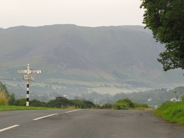
Embleton, Cumbria

Embleton is a small village and civil parish located in the Allerdale district in Cumbria, England. It is located east of Cockermouth on the A66 road,...

Embleton railway station

Embleton railway station was situated on the Cockermouth, Keswick and Penrith Railway between Penrith and Cockermouth in Cumberland (now in Cumbria), England...

Slate Fell

Slate Fell is a low hill in the North Western part of the English Lake District. It lies only about a mile from the busy market town of Cockermouth, and...

Lorton, Cumbria

Lorton, a parish in Cumberland, Cumbria, England, consists of two adjacent villages: Low Lorton and High Lorton. Both nestle at the northern end of the...

Wythop

Wythop is a civil parish in the north of Cumbria, England, between Cockermouth and Keswick. Population details are no longer maintained and can be found...

Nearby Amenities

Located within 500m of 54.636015,-3.3121563
Man Made: tower
Lat/Long: 54.6383351/-3.3104276
Armaside
Place: locality
Wikidata: Q4792891
Lat/Long: 54.6367109/-3.3185931
High Armaside
Place: locality
Lat/Long: 54.6358613/-3.3150056
wonsul How
Place: locality
Lat/Long: 54.6345548/-3.3185611
Power: pole
Lat/Long: 54.632552/-3.3080126
Power: pole
Lat/Long: 54.6332724/-3.308132
Power: pole
Lat/Long: 54.6340471/-3.3081722
Power: pole
Lat/Long: 54.634786/-3.3084458
Power: pole
Lat/Long: 54.6362236/-3.3103958
Power: pole
Lat/Long: 54.636874/-3.3117476
Power: pole
Lat/Long: 54.6375788/-3.313255
Power: pole
Lat/Long: 54.6382773/-3.3141267
Power: pole
Lat/Long: 54.6390395/-3.3151191
Power: pole
Lat/Long: 54.6396309/-3.3151084
Power: pole
Lat/Long: 54.6371671/-3.3180068
Power: pole
Lat/Long: 54.6363663/-3.3164592
The data included in this document is from www.openstreetmap.org. The data is made available under ODbL.

Have you been to Clint's Wood?

Leave your review of Clint's Wood below (or comments, questions and feedback).