High Coppice

Wood, Forest in Cumberland Copeland

England

High Coppice

Irton Road Station: Ravenglass and Eskdale Railway The station is situated in the very top of the grid square.
Irton Road Station: Ravenglass and Eskdale Railway Credit: Pam Brophy

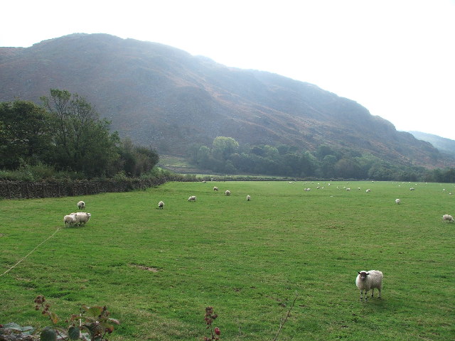
High Coppice is a stunning woodland situated in the county of Cumberland, England. Covering an expansive area of lush greenery, it is often referred to as a forest due to its dense vegetation and tall trees. The woodland is known for its exceptional beauty and is a popular destination for nature lovers and outdoor enthusiasts.

High Coppice is characterized by a variety of tree species, including oak, birch, beech, and ash, which create a diverse and vibrant ecosystem. The canopy of the forest provides ample shade, creating a cool and peaceful atmosphere even on hot summer days. The forest floor is adorned with a rich carpet of ferns, wildflowers, and mosses, adding to the enchanting ambiance of the woodland.

The woodland is home to a plethora of wildlife, making it a haven for animal lovers and birdwatchers. Visitors may spot a wide range of creatures, including deer, foxes, badgers, and squirrels. The forest is also a habitat for numerous bird species, such as woodpeckers, owls, and various songbirds, offering a symphony of natural sounds as one explores the area.

High Coppice offers an array of recreational activities for visitors to enjoy. There are numerous walking trails and hiking paths that meander through the woodland, allowing visitors to immerse themselves in the serene beauty of nature. The forest is also a popular spot for picnics, with several designated areas equipped with benches and tables.

Overall, High Coppice in Cumberland is a breathtaking woodland that offers a peaceful retreat from the hustle and bustle of daily life. With its picturesque scenery, diverse wildlife, and recreational opportunities, it is a must-visit destination for anyone seeking solace in nature.

If you have any feedback on the listing, please let us know in the comments section below.

High Coppice Images

Images are sourced within 2km of 54.369113/-3.3265503 or Grid Reference SD1397. Thanks to Geograph Open Source API. All images are credited.

Irton Road Station: Ravenglass and Eskdale Railway The station is situated in the very top of the grid square.
Irton Road Station: Ravenglass and Eskdale Railway
The station is situated in the very top of the grid square.
Water Crag across Linbeck Gill
Bridleway, Eskdale Bridleway heading west towards Muncaster Fell through a landscape of small fields and oakwoods.
Bridleway, Eskdale
Bridleway heading west towards Muncaster Fell through a landscape of small fields and oakwoods.
Water Crag. Looking SW from its neighbour Rough Crag.
Water Crag.
Looking SW from its neighbour Rough Crag.
Brantrake Moss Taken from just above Hare Gill.
Brantrake Moss
Taken from just above Hare Gill.
Brantrake Crags looking S from the near the road junction at SD 148 990
Brantrake Crags
looking S from the near the road junction at SD 148 990
Gate and stile at Brantrake. Gate at SD 145 985 where footpath enters wood near river Esk.
Gate and stile at Brantrake.
Gate at SD 145 985 where footpath enters wood near river Esk.
Forest How A bed-and-breakfast establishment in a quiet location.
Forest How
A bed-and-breakfast establishment in a quiet location.
Footpath on Muncaster Fell A relatively dry bit.
Footpath on Muncaster Fell
A relatively dry bit.
Rough Grazing Looking south-east
Rough Grazing
Looking south-east
Golf Course Looking south from the bridleway.
Golf Course
Looking south from the bridleway.
Timber Harvesting, Muncaster Fell
Roman Tile Kilns The sign reads "These Roman Tile kilns are protected as a monument of national importance under the Ancient Monuments Acts 1913-53. Ministry of Public Buildings & Works". More than imagination is required here. Even the latest OS map omits its earlier symbol.
Roman Tile Kilns
The sign reads "These Roman Tile kilns are protected as a monument of national importance under the Ancient Monuments Acts 1913-53. Ministry of Public Buildings & Works". More than imagination is required here. Even the latest OS map omits its earlier symbol.
Rough Grazing Land
Rough Grazing Land
High Coppice The older High Coppice wood now has a backdrop of more recent plantings.
High Coppice
The older High Coppice wood now has a backdrop of more recent plantings.
Stock's Bridge An unusual design, using galvanised steel, wire and timber. Crosses the River Esk.
Stock's Bridge
An unusual design, using galvanised steel, wire and timber. Crosses the River Esk.
River Esk At Stock's Bridge. Now in the final run-out into the sea, the crystal clear river meanders gently.
River Esk
At Stock's Bridge. Now in the final run-out into the sea, the crystal clear river meanders gently.
Eskdale Green Station on the Ravenglass & Eskdale Railway
Show me another place!

High Coppice is located at Grid Ref: SD1397 (Lat: 54.369113, Lng: -3.3265503)

Administrative County: Cumbria

District: Copeland

Police Authority: Cumbria

What 3 Words

///organisms.collide.mingles. Near Seascale, Cumbria

Related Wikis

Devoke Water

Devoke Water is a small lake in the south west of the Lake District in North West England. It is the largest tarn in the Lake District, a tarn being a...

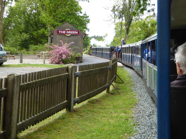
The Green railway station

The Green is a railway station on the 15-inch gauge Ravenglass & Eskdale Railway in the Lake District National Park and the English county of Cumbria....

Irton Road railway station

Irton Road railway station is a railway station on the 15 in gauge Ravenglass & Eskdale Railway in the Lake District National Park and the English county...

Eskdale Green

Eskdale Green is a village in Cumbria, England, 10 miles west of Coniston. Historically in Cumberland, it lies off the A595 road and is one of the few...

Nearby Amenities

Located within 500m of 54.369113,-3.3265503
Coppice How Plantation
Natural: wood
Lat/Long: 54.3669059/-3.3279371
Power: pole
Lat/Long: 54.3681163/-3.333057
Power: pole
Lat/Long: 54.3695525/-3.3311995
Power: pole
Lat/Long: 54.3701856/-3.3304127
Power: pole
Lat/Long: 54.3708869/-3.3295745
Power: pole
Lat/Long: 54.3714026/-3.3283558
Power: pole
Lat/Long: 54.3721013/-3.3268188
Power: pole
Lat/Long: 54.3727656/-3.325361
The data included in this document is from www.openstreetmap.org. The data is made available under ODbL.

Have you been to High Coppice?

Leave your review of High Coppice below (or comments, questions and feedback).