Churchstile Wood

Wood, Forest in Cumberland Copeland

England

Churchstile Wood

A camping field at Church Stile site
A camping field at Church Stile site Credit: David Medcalf

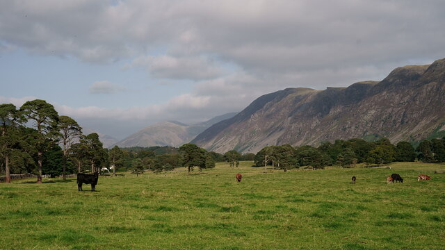
Churchstile Wood is a picturesque woodland located in the county of Cumberland, England. Spanning over a vast area, this serene forest boasts an abundance of natural beauty and is a popular destination for nature enthusiasts and outdoor adventurers alike.

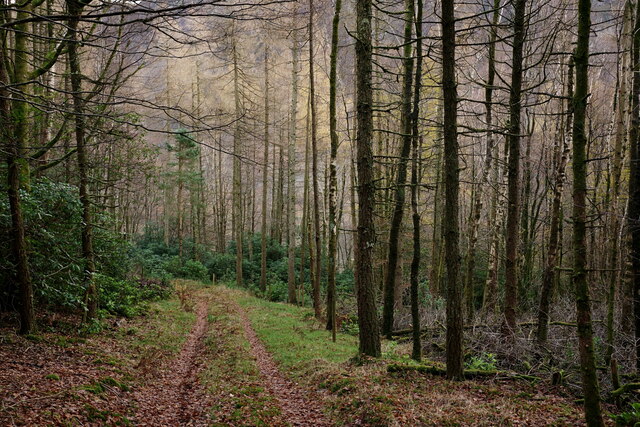
The woodland is characterized by its dense canopy of towering trees that create a tranquil and shaded atmosphere. The dominant tree species in Churchstile Wood include oak, beech, and birch, which provide a diverse and vibrant array of colors throughout the seasons. The forest floor is blanketed with a lush carpet of ferns, mosses, and wildflowers, adding to the enchanting ambiance.

Visitors to Churchstile Wood can explore the various walking trails that wind their way through the forest, allowing for a captivating journey through nature. These trails offer breathtaking vistas of the surrounding countryside and provide opportunities for bird watching and wildlife spotting. The wood is home to a variety of bird species, including woodpeckers, owls, and warblers, making it a haven for bird enthusiasts.

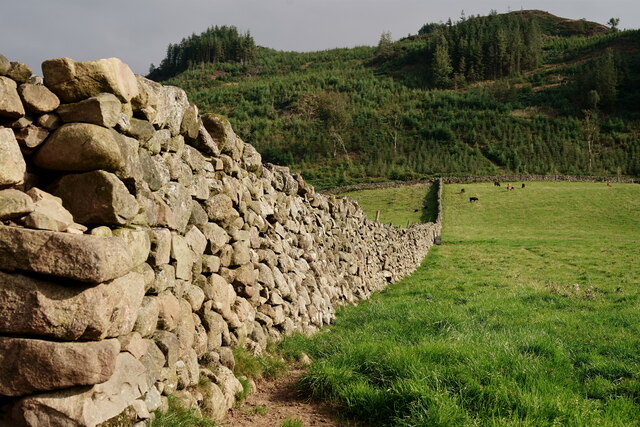
In addition to its natural beauty, Churchstile Wood also holds historical significance. It is believed to have been a part of the ancient hunting grounds of the local nobility, and remnants of old stone walls and boundary markers can still be found within the woodland.

Overall, Churchstile Wood is a captivating destination that offers a peaceful retreat from the hustle and bustle of everyday life. Its scenic trails, diverse flora and fauna, and rich history make it a must-visit location for those seeking to immerse themselves in the beauty of Cumberland's natural landscapes.

If you have any feedback on the listing, please let us know in the comments section below.

Churchstile Wood Images

Images are sourced within 2km of 54.426224/-3.3450732 or Grid Reference NY1204. Thanks to Geograph Open Source API. All images are credited.

A camping field at Church Stile site
Wasdale Woodland Private woodland. Sadly, due to disease, all rhododendron, larch and sweet chestnut in the wood have to be felled by May 2022.
Wasdale Woodland
Private woodland. Sadly, due to disease, all rhododendron, larch and sweet chestnut in the wood have to be felled by May 2022.
Wasdale View Looking towards The Screes from behind the wall boundary.
Wasdale View
Looking towards The Screes from behind the wall boundary.
Wasdale View Looking towards The Screes from behind the wall boundary.
Wasdale View
Looking towards The Screes from behind the wall boundary.
Wasdale View Looking towards The Screes from behind the wall boundary.
Wasdale View
Looking towards The Screes from behind the wall boundary.
Wasdale Wall Looking towards the road which leads to Nether Wasdale.
Wasdale Wall
Looking towards the road which leads to Nether Wasdale.
Wasdale Wall Looking in the direction of Latterbarrow. A plantation of diseased larch was felled in 2013 and subsequently re-planted (probably spruce).
Wasdale Wall
Looking in the direction of Latterbarrow. A plantation of diseased larch was felled in 2013 and subsequently re-planted (probably spruce).
Wasdale View from a footpath in Nether Wasdale, with Great Gable in the centre of picture.
Wasdale
View from a footpath in Nether Wasdale, with Great Gable in the centre of picture.
Wasdale View from a footpath in Nether Wasdale, with The Screes to the right of picture.
Wasdale
View from a footpath in Nether Wasdale, with The Screes to the right of picture.
Wasdale View from a footpath in Nether Wasdale, with Great Gable towards the right of picture.
Wasdale
View from a footpath in Nether Wasdale, with Great Gable towards the right of picture.
Wasdale View towards Yewbarrow, from the path at the base of Latterbarrow.
Wasdale
View towards Yewbarrow, from the path at the base of Latterbarrow.
Wasdale View from a footpath in Nether Wasdale. Great Gable is to the right of picture and 'The Flass' is the white building to the extreme left.
Wasdale
View from a footpath in Nether Wasdale. Great Gable is to the right of picture and 'The Flass' is the white building to the extreme left.
Wasdale View towards The Screes, from a footpath in Nether Wasdale.
Wasdale
View towards The Screes, from a footpath in Nether Wasdale.
Wasdale Looking along the road to Nether Wasdale.
Wasdale
Looking along the road to Nether Wasdale.
Wilkinson’s Wood
Wilkinson’s Wood
Ben Garth A farm beside the Gosforth to Nether Wasdale road, Ben Garth is spelled as Bengarth on Ordnance Survey maps.
There is an Ordnance Survey cut benchmark on the bottom of the door jamb at the right hand side of the barn door (photograph <a href="https://www.geograph.org.uk/photo/7118747">NY1104 : Benchmark, Ben Garth</a>).
Ben Garth
A farm beside the Gosforth to Nether Wasdale road, Ben Garth is spelled as Bengarth on Ordnance Survey maps. There is an Ordnance Survey cut benchmark on the bottom of the door jamb at the right hand side of the barn door (photograph NY1104 : Benchmark, Ben Garth).
Benchmark, Ben Garth Detail of the Ordnance Survey cut benchmark on the bottom of the door jamb of a barn door at Ben Garth (spelled as Bengarth on Ordnance Survey maps). The benchmark marks a height of 52.1549m above mean sea level (Ordnance Datum Newlyn) last levelled and verified in 1952 (location photograph <a href="https://www.geograph.org.uk/photo/7118733">NY1104 : Ben Garth</a>).
Benchmark, Ben Garth
Detail of the Ordnance Survey cut benchmark on the bottom of the door jamb of a barn door at Ben Garth (spelled as Bengarth on Ordnance Survey maps). The benchmark marks a height of 52.1549m above mean sea level (Ordnance Datum Newlyn) last levelled and verified in 1952 (location photograph NY1104 : Ben Garth).
Ben Garth The road from Gosforth to Nether Wasdale approaching the farm at Ben Garth.
Ben Garth is spelled as Bengarth on Ordnance Survey Maps.
Ben Garth
The road from Gosforth to Nether Wasdale approaching the farm at Ben Garth. Ben Garth is spelled as Bengarth on Ordnance Survey Maps.
Show me another place!

Churchstile Wood is located at Grid Ref: NY1204 (Lat: 54.426224, Lng: -3.3450732)

Administrative County: Cumbria

District: Copeland

Police Authority: Cumbria

What 3 Words

///promoting.quintet.snoring. Near Seascale, Cumbria

Related Wikis

Wasdale, Eskdale and Duddon

Wasdale, Eskdale and Duddon is an area of protected countryside, now held as National Trust property: it is part of the Lake District, located in south...

Wasdale

Wasdale (; traditionally ) is a valley and civil parish in the western part of the Lake District National Park in Cumbria, England. The River Irt flows...

St Michael & All Angels, Nether Wasdale

St Michael & All Angels' Church in Nether Wasdale, Cumbria, England, is an active Anglican parish church in the deanery of Calder, and the diocese of Carlisle...

Nether Wasdale

Nether Wasdale is a village in Cumbria, England, located in the valley and civil parish of Wasdale, near the River Irt and just over a mile to the west...

Buckbarrow

Buckbarrow is a small fell in the English Lake District overlooking the western end of Wastwater. It is featured in Alfred Wainwright’s Pictorial Guide...

Whin Rigg

Whin Rigg is a fell in the English Lake District, situated in the western segment of the national park, 22 kilometres (14 miles) south east of the town...

Bamse's Wood

Bamse's Wood is a newly planted forest and nature reserve that sits between Gosforth and Nether Wasdale in the Lake District, Cumbria, England. The 17...

Irton Pike

Irton Pike is a hill in the west of the English Lake District, near Santon Bridge, Cumbria. It is the subject of a chapter of Alfred Wainwright's book...

Nearby Amenities

Located within 500m of 54.426224,-3.3450732
School
Lat/Long: 54.4245304/-3.3510513
Barrier: stile
Material: wood
Source: survey;bing;gps
Stile: stepover
Lat/Long: 54.4288847/-3.3465468
Parking
Access: yes
Capacity: 8
Fee: yes
Operator: National Trust
Operator Type: charitable
Operator Wikidata: Q333515
Parking: surface
Lat/Long: 54.4221267/-3.3456912
Murt
Place: isolated_dwelling
Lat/Long: 54.4242554/-3.3409752
Mill Place
Place: isolated_dwelling
Lat/Long: 54.4255054/-3.3421748
Bicycle Parking
Bicycle Parking: stands
Lat/Long: 54.4221763/-3.3439682
Bus Stop
Nether Wasdale Car Park
Bus: yes
Public Transport: platform
Lat/Long: 54.422306/-3.3448495
Drinking Water
Lat/Long: 54.4263277/-3.3504204
Drinking Water
Lat/Long: 54.4258887/-3.3493524
Toilets
Lat/Long: 54.425481/-3.3501495
Give Way
Direction: backward
Lat/Long: 54.4229324/-3.3446922
Give Way
Direction: backward
Lat/Long: 54.4219387/-3.3447057
Give Way
Direction: forward
Lat/Long: 54.422977/-3.3423531
Power: pole
Lat/Long: 54.42222/-3.3433158
Power: pole
Lat/Long: 54.422159/-3.3421706
Power: pole
Lat/Long: 54.4251329/-3.3413169
Power: pole
Lat/Long: 54.4224955/-3.3481693
Power: pole
Lat/Long: 54.4231086/-3.3500271
Power: pole
Lat/Long: 54.4233503/-3.350715
The data included in this document is from www.openstreetmap.org. The data is made available under ODbL.

Have you been to Churchstile Wood?

Leave your review of Churchstile Wood below (or comments, questions and feedback).