Birks Wood

Wood, Forest in Cumberland Copeland

England

Birks Wood

Minor road north of Hawkbarrow Farm The minor road passing to the north of Hawkbarrow Farm.
Minor road north of Hawkbarrow Farm Credit: Graham Robson

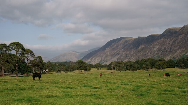
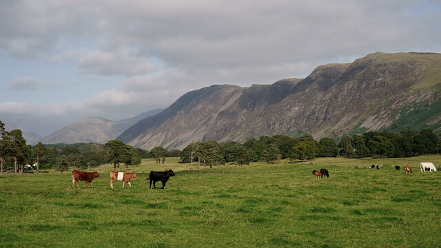
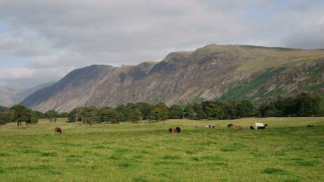
Birks Wood is a picturesque forest located in Cumberland, a county in the northwest of England. This ancient woodland covers an area of approximately 150 acres and is renowned for its natural beauty and diverse plant and animal life.

The woodland is predominantly made up of broadleaf trees, including oak, beech, and ash, which create a dense canopy that filters sunlight, creating a pleasant and shaded environment. The forest floor is covered in a carpet of mosses, ferns, and wildflowers, adding to the enchanting atmosphere of the wood.

Birks Wood is home to a wide range of wildlife, with several species of birds, mammals, and insects making it their habitat. Visitors may be lucky enough to spot a variety of bird species, such as woodpeckers, owls, and songbirds, as well as mammals like deer, foxes, and squirrels. The wood is also known for its vibrant butterfly population, with numerous species fluttering amidst the trees during the warmer months.

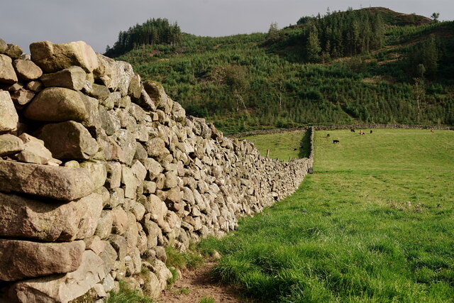
The forest is crisscrossed by a network of well-maintained footpaths, allowing visitors to explore its natural wonders at their own pace. These paths lead to hidden clearings, bubbling streams, and small ponds, providing opportunities for peaceful reflection and wildlife observation.

Birks Wood is a popular destination for nature lovers, hikers, and families seeking a tranquil retreat. Its stunning scenery, abundant wildlife, and serene atmosphere make it a must-visit location for anyone wishing to immerse themselves in the beauty of the English countryside.

If you have any feedback on the listing, please let us know in the comments section below.

Birks Wood Images

Images are sourced within 2km of 54.424097/-3.3592303 or Grid Reference NY1104. Thanks to Geograph Open Source API. All images are credited.

Minor road north of Hawkbarrow Farm The minor road passing to the north of Hawkbarrow Farm.
Minor road north of Hawkbarrow Farm
The minor road passing to the north of Hawkbarrow Farm.
A camping field at Church Stile site
Wasdale View Looking towards The Screes from behind the wall boundary.
Wasdale View
Looking towards The Screes from behind the wall boundary.
Wasdale View Looking towards The Screes from behind the wall boundary.
Wasdale View
Looking towards The Screes from behind the wall boundary.
Wasdale View Looking towards The Screes from behind the wall boundary.
Wasdale View
Looking towards The Screes from behind the wall boundary.
Wasdale Wall Looking towards the road which leads to Nether Wasdale.
Wasdale Wall
Looking towards the road which leads to Nether Wasdale.
Wasdale Wall Looking in the direction of Latterbarrow. A plantation of diseased larch was felled in 2013 and subsequently re-planted (probably spruce).
Wasdale Wall
Looking in the direction of Latterbarrow. A plantation of diseased larch was felled in 2013 and subsequently re-planted (probably spruce).
Wasdale View from a footpath in Nether Wasdale, with Great Gable in the centre of picture.
Wasdale
View from a footpath in Nether Wasdale, with Great Gable in the centre of picture.
Wasdale View from a footpath in Nether Wasdale, with The Screes to the right of picture.
Wasdale
View from a footpath in Nether Wasdale, with The Screes to the right of picture.
Wasdale View from a footpath in Nether Wasdale, with Great Gable towards the right of picture.
Wasdale
View from a footpath in Nether Wasdale, with Great Gable towards the right of picture.
Wasdale View towards Yewbarrow, from the path at the base of Latterbarrow.
Wasdale
View towards Yewbarrow, from the path at the base of Latterbarrow.
Wasdale View from a footpath in Nether Wasdale. Great Gable is to the right of picture and 'The Flass' is the white building to the extreme left.
Wasdale
View from a footpath in Nether Wasdale. Great Gable is to the right of picture and 'The Flass' is the white building to the extreme left.
Wasdale View towards The Screes, from a footpath in Nether Wasdale.
Wasdale
View towards The Screes, from a footpath in Nether Wasdale.
Wasdale Looking along the road to Nether Wasdale.
Wasdale
Looking along the road to Nether Wasdale.
Benchmark, Hermons Hill Detail of the Ordnance Survey cut benchmark on the corner of a barn at Hermons Hill.  The benchmark appears to have been filled and this was possibly done to indicate cancellation when it was superseded by flush bracket benchmark G3100, below this benchmark on the same wall (photograph <a href="https://www.geograph.org.uk/photo/7118351">NY1004 : Flush bracket benchmark, Hermons Hill</a>).
The 1899 edition Ordnance Survey map shows this benchmark marking a height of 157.9ft above mean sea level, Ordnance Datum Newlyn.
Location photograph <a href="https://www.geograph.org.uk/photo/7118657">NY1004 : Corner of the barn, Hermons Hill</a>.
Benchmark, Hermons Hill
Detail of the Ordnance Survey cut benchmark on the corner of a barn at Hermons Hill. The benchmark appears to have been filled and this was possibly done to indicate cancellation when it was superseded by flush bracket benchmark G3100, below this benchmark on the same wall (photograph NY1004 : Flush bracket benchmark, Hermons Hill). The 1899 edition Ordnance Survey map shows this benchmark marking a height of 157.9ft above mean sea level, Ordnance Datum Newlyn. Location photograph NY1004 : Corner of the barn, Hermons Hill.
Flush bracket benchmark, Hermons Hill Detail of the Ordnance Survey flush bracket benchmark number G3100 on the corner of a barn at Hermons Hill.  The benchmark marks a height of 47.793m above mean sea level (Ordnance Datum Newlyn) last levelled and verified in 1954.
There is an older, cancelled Ordnance Survey cut benchmark on the same wall directly above this benchmark (photograph <a href="https://www.geograph.org.uk/photo/7118276">NY1004 : Benchmark, Hermons Hill</a>).
Location photograph <a href="https://www.geograph.org.uk/photo/7118657">NY1004 : Corner of the barn, Hermons Hill</a>.
Flush bracket benchmark, Hermons Hill
Detail of the Ordnance Survey flush bracket benchmark number G3100 on the corner of a barn at Hermons Hill. The benchmark marks a height of 47.793m above mean sea level (Ordnance Datum Newlyn) last levelled and verified in 1954. There is an older, cancelled Ordnance Survey cut benchmark on the same wall directly above this benchmark (photograph NY1004 : Benchmark, Hermons Hill). Location photograph NY1004 : Corner of the barn, Hermons Hill.
Road near Hermons Hill This is the road from Gosforth to Nether Wasdale.
Road near Hermons Hill
This is the road from Gosforth to Nether Wasdale.
Wilkinson’s Wood
Wilkinson’s Wood
Show me another place!

Birks Wood is located at Grid Ref: NY1104 (Lat: 54.424097, Lng: -3.3592303)

Administrative County: Cumbria

District: Copeland

Police Authority: Cumbria

What 3 Words

///melon.stocked.geek. Near Seascale, Cumbria

Related Wikis

Nether Wasdale

Nether Wasdale is a village in Cumbria, England, located in the valley and civil parish of Wasdale, near the River Irt and just over a mile to the west...

St Michael & All Angels, Nether Wasdale

St Michael & All Angels' Church in Nether Wasdale, Cumbria, England, is an active Anglican parish church in the deanery of Calder, and the diocese of Carlisle...

Wasdale

Wasdale (; traditionally ) is a valley and civil parish in the western part of the Lake District National Park in Cumbria, England. The River Irt flows...

Wasdale, Eskdale and Duddon

Wasdale, Eskdale and Duddon is an area of protected countryside, now held as National Trust property: it is part of the Lake District, located in south...

Bamse's Wood

Bamse's Wood is a newly planted forest and nature reserve that sits between Gosforth and Nether Wasdale in the Lake District, Cumbria, England. The 17...

River Bleng

The River Bleng is a tributary of the River Irt in the county of Cumbria in northern England.The river gives its name to the valley that it flows through...

Borough of Copeland

The Borough of Copeland was a local government district with borough status in western Cumbria, England. Its council was based in Whitehaven. It was...

Copeland (UK Parliament constituency)

Copeland is a constituency in Cumbria created in 1983 and represented in the House of Commons of the UK Parliament. The constituency is represented in...

Nearby Amenities

Located within 500m of 54.424097,-3.3592303
Nether Wasdale
Created By: Potlatch 0.10b
Place: village
Source: npe
Wikidata: Q6998987
Lat/Long: 54.4245362/-3.3526003
Barrier: stile
Lat/Long: 54.4208181/-3.362062
Post Box
Ref: CA20 98
Lat/Long: 54.4241242/-3.3525115
Berry How
Place: locality
Lat/Long: 54.4277719/-3.3605366
Barrier: cattle_grid
Lat/Long: 54.4273718/-3.3562768
Power: pole
Lat/Long: 54.4247538/-3.3568833
Power: pole
Lat/Long: 54.4256295/-3.357554
Power: pole
Lat/Long: 54.4265219/-3.3582343
Power: pole
Lat/Long: 54.4278433/-3.358905
Power: pole
Lat/Long: 54.4250487/-3.3581142
Power: pole
Lat/Long: 54.4253879/-3.3596901
Power: pole
Lat/Long: 54.4253768/-3.3617005
Power: pole
Lat/Long: 54.4253668/-3.3636594
Power: pole
Lat/Long: 54.4253491/-3.3651381
Power: pole
Lat/Long: 54.4200642/-3.3617938
Power: pole
Lat/Long: 54.4210465/-3.3619177
Power: pole
Lat/Long: 54.4218858/-3.3620339
Power: pole
Lat/Long: 54.4226419/-3.3631506
Power: pole
Lat/Long: 54.423133/-3.3631106
Power: pole
Lat/Long: 54.4239922/-3.3633221
Power: pole
Lat/Long: 54.424644/-3.3634802
The data included in this document is from www.openstreetmap.org. The data is made available under ODbL.

Have you been to Birks Wood?

Leave your review of Birks Wood below (or comments, questions and feedback).