Gosforth Hall Plantation

Wood, Forest in Cumberland Copeland

England

Gosforth Hall Plantation

Trees in Blengdale Forest An area of mature planting within Blengdale Forest. Some of the trees on the edge of the block appear to have succumbed to wind damage, probably exacerbated by the trees on the opposite side of the track being felled fairly recently.
Trees in Blengdale Forest Credit: Graham Robson

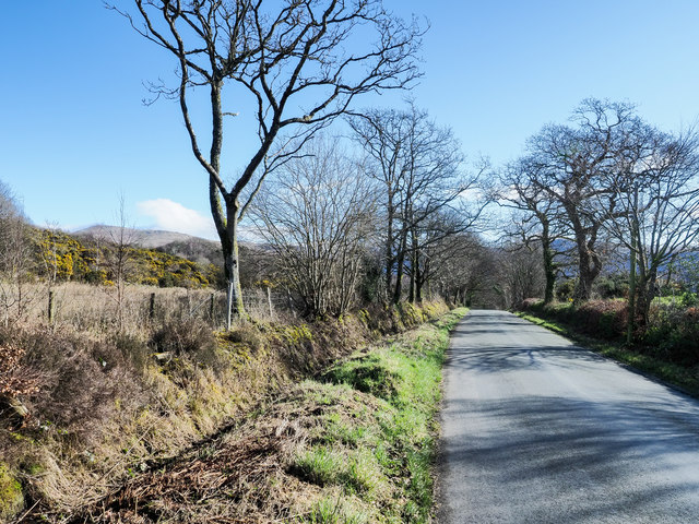
Gosforth Hall Plantation, located in Cumberland, England, is a historic and picturesque estate nestled in a dense woodland area known as the Gosforth Forest. Spread across a vast expanse, the plantation is known for its dense and diverse flora, making it a haven for nature enthusiasts and botanists alike.

The plantation boasts an impressive variety of trees, including oak, birch, ash, and beech, which create a lush and verdant environment. The woodland is also home to a wide array of wildlife, such as deer, foxes, and various species of birds, making it a popular destination for wildlife enthusiasts and birdwatchers.

Gosforth Hall, the main residence on the plantation, is a stately Georgian mansion, steeped in history. Built in the 18th century, it stands as a testament to the grandeur and elegance of the era. The hall features exquisite architectural details, such as ornate plasterwork, grand staircases, and beautifully landscaped gardens.

The plantation offers various recreational activities for visitors, including guided nature walks, birdwatching tours, and picnicking spots. There are also designated areas for camping and hiking, allowing visitors to fully immerse themselves in the natural beauty of the surrounding woodland.

Gosforth Hall Plantation is not only a place of natural beauty but also a historical landmark, showcasing the architectural and cultural heritage of Cumberland. With its lush woodland, diverse wildlife, and stunning Georgian mansion, the plantation is a must-visit destination for those seeking a tranquil escape into nature and history.

If you have any feedback on the listing, please let us know in the comments section below.

Gosforth Hall Plantation Images

Images are sourced within 2km of 54.43413/-3.3788035 or Grid Reference NY1005. Thanks to Geograph Open Source API. All images are credited.

Trees in Blengdale Forest An area of mature planting within Blengdale Forest. Some of the trees on the edge of the block appear to have succumbed to wind damage, probably exacerbated by the trees on the opposite side of the track being felled fairly recently.
Trees in Blengdale Forest
An area of mature planting within Blengdale Forest. Some of the trees on the edge of the block appear to have succumbed to wind damage, probably exacerbated by the trees on the opposite side of the track being felled fairly recently.
Clear felled area within Blengdale Forest A large area of forest cleared of all trees, a bleak expanse of open ground on a wet day at the start of November.
Clear felled area within Blengdale Forest
A large area of forest cleared of all trees, a bleak expanse of open ground on a wet day at the start of November.
Track in Blengdale Forest A track through Blengdale Forest. A footpath follows the track.
Track in Blengdale Forest
A track through Blengdale Forest. A footpath follows the track.
Farm track east of Rainors A farm track passing between the farms of Rainors and Julian Holme. A public bridleway follows the track.
Farm track east of Rainors
A farm track passing between the farms of Rainors and Julian Holme. A public bridleway follows the track.
Hawkbarrow Farm Looking down the short lane to the farm buildings and house at Hawkbarrow Farm. The large pond in front of the steading appears to be a recent addition.
Hawkbarrow Farm
Looking down the short lane to the farm buildings and house at Hawkbarrow Farm. The large pond in front of the steading appears to be a recent addition.
Minor road north of Hawkbarrow Farm The minor road passing to the north of Hawkbarrow Farm.
Minor road north of Hawkbarrow Farm
The minor road passing to the north of Hawkbarrow Farm.
Minor road heading west The road connects Wasdale Head with Gosforth.
Seatallan is the hill on the horizon to the left of the most prominent tree.
Minor road heading west
The road connects Wasdale Head with Gosforth. Seatallan is the hill on the horizon to the left of the most prominent tree.
Julian Holme Farm The Denwoods are clearly proud of their herd.
Julian Holme Farm
The Denwoods are clearly proud of their herd.
Hawkbarrow Farm Just off the minor road that leads from Gosforth to Nether Wasdale.
Hawkbarrow Farm
Just off the minor road that leads from Gosforth to Nether Wasdale.
Between Guards Farm. Possibly something to stop the rustlers but I cannot be certain.
Between Guards Farm.
Possibly something to stop the rustlers but I cannot be certain.
Forest Track into Blengdale
Benchmark, Hermons Hill Detail of the Ordnance Survey cut benchmark on the corner of a barn at Hermons Hill.  The benchmark appears to have been filled and this was possibly done to indicate cancellation when it was superseded by flush bracket benchmark G3100, below this benchmark on the same wall (photograph <a href="https://www.geograph.org.uk/photo/7118351">NY1004 : Flush bracket benchmark, Hermons Hill</a>).
The 1899 edition Ordnance Survey map shows this benchmark marking a height of 157.9ft above mean sea level, Ordnance Datum Newlyn.
Location photograph <a href="https://www.geograph.org.uk/photo/7118657">NY1004 : Corner of the barn, Hermons Hill</a>.
Benchmark, Hermons Hill
Detail of the Ordnance Survey cut benchmark on the corner of a barn at Hermons Hill. The benchmark appears to have been filled and this was possibly done to indicate cancellation when it was superseded by flush bracket benchmark G3100, below this benchmark on the same wall (photograph NY1004 : Flush bracket benchmark, Hermons Hill). The 1899 edition Ordnance Survey map shows this benchmark marking a height of 157.9ft above mean sea level, Ordnance Datum Newlyn. Location photograph NY1004 : Corner of the barn, Hermons Hill.
Flush bracket benchmark, Hermons Hill Detail of the Ordnance Survey flush bracket benchmark number G3100 on the corner of a barn at Hermons Hill.  The benchmark marks a height of 47.793m above mean sea level (Ordnance Datum Newlyn) last levelled and verified in 1954.
There is an older, cancelled Ordnance Survey cut benchmark on the same wall directly above this benchmark (photograph <a href="https://www.geograph.org.uk/photo/7118276">NY1004 : Benchmark, Hermons Hill</a>).
Location photograph <a href="https://www.geograph.org.uk/photo/7118657">NY1004 : Corner of the barn, Hermons Hill</a>.
Flush bracket benchmark, Hermons Hill
Detail of the Ordnance Survey flush bracket benchmark number G3100 on the corner of a barn at Hermons Hill. The benchmark marks a height of 47.793m above mean sea level (Ordnance Datum Newlyn) last levelled and verified in 1954. There is an older, cancelled Ordnance Survey cut benchmark on the same wall directly above this benchmark (photograph NY1004 : Benchmark, Hermons Hill). Location photograph NY1004 : Corner of the barn, Hermons Hill.
Road near Hermons Hill This is the road from Gosforth to Nether Wasdale.
Road near Hermons Hill
This is the road from Gosforth to Nether Wasdale.
Wilkinson’s Wood
Wilkinson’s Wood
Hermons Hill The road is from Gosforth to Nether Wasdale and the mountain in the background is Whin Rigg. 
There are two Ordnance Survey benchmarks on the corner of the barn behind the bush at the far end of the building (photograph <a href="https://www.geograph.org.uk/photo/7118657">NY1004 : Corner of the barn, Hermons Hill</a>).
Hermons Hill
The road is from Gosforth to Nether Wasdale and the mountain in the background is Whin Rigg. There are two Ordnance Survey benchmarks on the corner of the barn behind the bush at the far end of the building (photograph NY1004 : Corner of the barn, Hermons Hill).
Corner of the barn, Hermons Hill Detail of the corner of the barn at Hermons Hill.
There are two Ordnance Survey benchmarks visible; the lower rectangular one is flush bracket benchmark G3100 (photograph <a href="https://www.geograph.org.uk/photo/7118351">NY1004 : Flush bracket benchmark, Hermons Hill</a>) and above it, less distinct, is an older cancelled cut benchmark (photograph <a href="https://www.geograph.org.uk/photo/7118276">NY1004 : Benchmark, Hermons Hill</a>).
Corner of the barn, Hermons Hill
Detail of the corner of the barn at Hermons Hill. There are two Ordnance Survey benchmarks visible; the lower rectangular one is flush bracket benchmark G3100 (photograph NY1004 : Flush bracket benchmark, Hermons Hill) and above it, less distinct, is an older cancelled cut benchmark (photograph NY1004 : Benchmark, Hermons Hill).
Ben Garth A farm beside the Gosforth to Nether Wasdale road, Ben Garth is spelled as Bengarth on Ordnance Survey maps.
There is an Ordnance Survey cut benchmark on the bottom of the door jamb at the right hand side of the barn door (photograph <a href="https://www.geograph.org.uk/photo/7118747">NY1104 : Benchmark, Ben Garth</a>).
Ben Garth
A farm beside the Gosforth to Nether Wasdale road, Ben Garth is spelled as Bengarth on Ordnance Survey maps. There is an Ordnance Survey cut benchmark on the bottom of the door jamb at the right hand side of the barn door (photograph NY1104 : Benchmark, Ben Garth).
Show me another place!

Gosforth Hall Plantation is located at Grid Ref: NY1005 (Lat: 54.43413, Lng: -3.3788035)

Administrative County: Cumbria

District: Copeland

Police Authority: Cumbria

What 3 Words

///play.bins.pumps. Near Seascale, Cumbria

Related Wikis

Bamse's Wood

Bamse's Wood is a newly planted forest and nature reserve that sits between Gosforth and Nether Wasdale in the Lake District, Cumbria, England. The 17...

Borough of Copeland

The Borough of Copeland was a local government district with borough status in western Cumbria, England. Its council was based in Whitehaven. It was...

Copeland (UK Parliament constituency)

Copeland is a constituency in Cumbria created in 1983 and represented in the House of Commons of the UK Parliament. The constituency is represented in...

River Bleng

The River Bleng is a tributary of the River Irt in the county of Cumbria in northern England.The river gives its name to the valley that it flows through...

St Michael & All Angels, Nether Wasdale

St Michael & All Angels' Church in Nether Wasdale, Cumbria, England, is an active Anglican parish church in the deanery of Calder, and the diocese of Carlisle...

Wasdale

Wasdale (; traditionally ) is a valley and civil parish in the western part of the Lake District National Park in Cumbria, England. The River Irt flows...

Nether Wasdale

Nether Wasdale is a village in Cumbria, England, located in the valley and civil parish of Wasdale, near the River Irt and just over a mile to the west...

Wasdale, Eskdale and Duddon

Wasdale, Eskdale and Duddon is an area of protected countryside, now held as National Trust property: it is part of the Lake District, located in south...

Nearby Amenities

Located within 500m of 54.43413,-3.3788035
Wilkinsons Wood
Natural: wood
Lat/Long: 54.4300718/-3.3784171
Bolton Wood
Natural: wood
Lat/Long: 54.4319235/-3.3785936
Meolbank Plantation
Place: locality
Lat/Long: 54.4350479/-3.3742601
Gosforth Hall Plantation
Natural: wood
Lat/Long: 54.4339871/-3.3846456
The data included in this document is from www.openstreetmap.org. The data is made available under ODbL.

Have you been to Gosforth Hall Plantation?

Leave your review of Gosforth Hall Plantation below (or comments, questions and feedback).