Bleng Tongue

Wood, Forest in Cumberland Copeland

England

Bleng Tongue

Trees in Blengdale Forest An area of mature planting within Blengdale Forest. Some of the trees on the edge of the block appear to have succumbed to wind damage, probably exacerbated by the trees on the opposite side of the track being felled fairly recently.
Trees in Blengdale Forest Credit: Graham Robson

Bleng Tongue is a small woodland area located in the county of Cumberland, in the northwest region of England. Situated within the picturesque Lake District National Park, this tranquil forest offers visitors a peaceful retreat amidst nature's beauty.

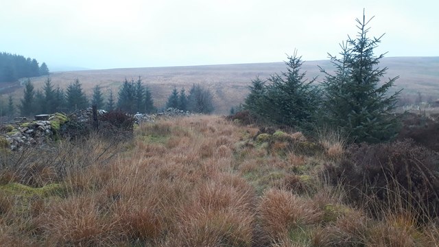
Covering an area of approximately 200 acres, Bleng Tongue is characterized by its dense and mature woodlands. The forest is predominantly composed of native tree species such as oak, beech, and ash, which provide a rich habitat for a variety of wildlife. Visitors can expect to encounter numerous bird species, including woodpeckers and owls, as well as small mammals like squirrels and rabbits.

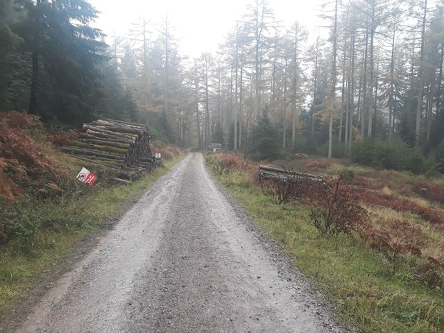
Bleng Tongue offers a range of activities for outdoor enthusiasts. There are several walking trails that wind their way through the woodland, providing opportunities for leisurely strolls or more challenging hikes. The paths are well-maintained, allowing visitors to explore the forest's diverse flora and fauna at their own pace.

For those interested in wildlife spotting, Bleng Tongue offers designated observation points and hides, which provide excellent vantage points to observe the woodland inhabitants. Additionally, the forest features picnic areas and benches, allowing visitors to relax and enjoy the peaceful surroundings.

Bleng Tongue is easily accessible, with ample parking available nearby. The forest is open to the public year-round, although it is advisable to check for any temporary closures or restrictions. Whether one seeks solitude, a connection with nature, or a simple escape from the hustle and bustle of daily life, Bleng Tongue is a perfect destination for all nature lovers.

If you have any feedback on the listing, please let us know in the comments section below.

Bleng Tongue Images

Images are sourced within 2km of 54.451733/-3.4010506 or Grid Reference NY0907. Thanks to Geograph Open Source API. All images are credited.

Trees in Blengdale Forest An area of mature planting within Blengdale Forest. Some of the trees on the edge of the block appear to have succumbed to wind damage, probably exacerbated by the trees on the opposite side of the track being felled fairly recently.
Trees in Blengdale Forest
An area of mature planting within Blengdale Forest. Some of the trees on the edge of the block appear to have succumbed to wind damage, probably exacerbated by the trees on the opposite side of the track being felled fairly recently.
Clear felled area within Blengdale Forest A large area of forest cleared of all trees, a bleak expanse of open ground on a wet day at the start of November.
Clear felled area within Blengdale Forest
A large area of forest cleared of all trees, a bleak expanse of open ground on a wet day at the start of November.
Bridleway descending to the River Bleng A bridleway picks its way down the slope towards the river between a block of planting and a dry stone wall.
Bridleway descending to the River Bleng
A bridleway picks its way down the slope towards the river between a block of planting and a dry stone wall.
The River Bleng The River Bleng carrying a lot of water downstream on a persistently rainy November day. There are, according to maps, stepping stones somewhere under the torrent of water allowing bridleway users to cross the river, I wasn't mad enough to try crossing however.
The River Bleng
The River Bleng carrying a lot of water downstream on a persistently rainy November day. There are, according to maps, stepping stones somewhere under the torrent of water allowing bridleway users to cross the river, I wasn't mad enough to try crossing however.
Track in Blengdale Forest A track through Blengdale Forest. A footpath follows the track.
Track in Blengdale Forest
A track through Blengdale Forest. A footpath follows the track.
Log piles beside the track, Blengdale Forest Evidence of ongoing work in Blengdale Forest in the form of piles of cut logs stacked beside the track through the forest.
Log piles beside the track, Blengdale Forest
Evidence of ongoing work in Blengdale Forest in the form of piles of cut logs stacked beside the track through the forest.
Moorland of Ponsonby Fell Ponsonby Fell is a moorland hill rising to just 315 m.; its summit is out of view to the right, Swainson Knott being the distant summit.
Moorland of Ponsonby Fell
Ponsonby Fell is a moorland hill rising to just 315 m.; its summit is out of view to the right, Swainson Knott being the distant summit.
Grass with rushes at southern Ponsonby Fell The area is a vague rise to the south of Ponsonby Fell's summit.
The snow-scattered mountains in the distance lie between Wasdale and Ennerdale; Seatallan is the isolated peak to the right.
Grass with rushes at southern Ponsonby Fell
The area is a vague rise to the south of Ponsonby Fell's summit. The snow-scattered mountains in the distance lie between Wasdale and Ennerdale; Seatallan is the isolated peak to the right.
Walling at Stone Pike There's nothing of a pike at Stone Pike. The location is just a minor rise to the south of Swainson Knott in a large area enclosed by a semi-ruinous dry stone wall; part of that wall is seen in the image.
In the distance, Seatallan is seen to the left with Illgill Head and Whin Rigg centre and right.
Walling at Stone Pike
There's nothing of a pike at Stone Pike. The location is just a minor rise to the south of Swainson Knott in a large area enclosed by a semi-ruinous dry stone wall; part of that wall is seen in the image. In the distance, Seatallan is seen to the left with Illgill Head and Whin Rigg centre and right.
Grassy moorland of Ponsonby Fell The gently declining northern slope of the hill just north of the summit with the slightly higher Swainson Knott beyond.
Grassy moorland of Ponsonby Fell
The gently declining northern slope of the hill just north of the summit with the slightly higher Swainson Knott beyond.
Grassy slope on Swainson Knott Grass and rushes on the western slope of Swainson Knott just below the summit.
Lank Rigg is the lightly snowed hill in the distance.
Grassy slope on Swainson Knott
Grass and rushes on the western slope of Swainson Knott just below the summit. Lank Rigg is the lightly snowed hill in the distance.
Ponsonby Fell Parked opposite ford to Laverock Hall, then reasonable going to Ponsonby Fell, Stone Pike and Swainson Knott. Grey day.
Name: Ponsonby Fell
Hill number: 2509
Height: 315m / 1033ft
Area: 34B: Lake District - Central & Western Fells
Class: WO,B
Grid ref: NY 08197 07024
Summit feature: cairn
Drop: 34m
Col: 281m  NY080074
Ponsonby Fell
Parked opposite ford to Laverock Hall, then reasonable going to Ponsonby Fell, Stone Pike and Swainson Knott. Grey day. Name: Ponsonby Fell Hill number: 2509 Height: 315m / 1033ft Area: 34B: Lake District - Central & Western Fells Class: WO,B Grid ref: NY 08197 07024 Summit feature: cairn Drop: 34m Col: 281m NY080074
Swainson Knott Parked opposite ford to Laverock Hall, then reasonable going to Ponsonby Fell, Stone Pike and Swainson Knott. Grey day.
Name: Swainson Knott
Hill number: 3801
Height: 345m / 1132ft
Area: 34B: Lake District - Central & Western Fells
Class: Hu,B
Grid ref: NY 07954 08351
Summit feature: small cairn with bovine bones
Drop: 132m
Col: 213m  NY089081
Swainson Knott
Parked opposite ford to Laverock Hall, then reasonable going to Ponsonby Fell, Stone Pike and Swainson Knott. Grey day. Name: Swainson Knott Hill number: 3801 Height: 345m / 1132ft Area: 34B: Lake District - Central & Western Fells Class: Hu,B Grid ref: NY 07954 08351 Summit feature: small cairn with bovine bones Drop: 132m Col: 213m NY089081
Skalderscew Beck Waterfall Came across this waterfall while exploring a ravine below Gait Kirk
Skalderscew Beck Waterfall
Came across this waterfall while exploring a ravine below Gait Kirk
Skalderskew Beck ravine Skalderskew Beck a ravine below Gait Kirk
Skalderskew Beck ravine
Skalderskew Beck a ravine below Gait Kirk
The summit of Ponsonby Fell Swainson Knott in the distance.
The summit of Ponsonby Fell
Swainson Knott in the distance.
The south slopes of Ponsonby Fell Black Combe <a href="https://www.geograph.org.uk/gridref/SD1385">SD1385</a>, the most southerly hill in the Lake District, is directly ahead in the distance.
The south slopes of Ponsonby Fell
Black Combe SD1385, the most southerly hill in the Lake District, is directly ahead in the distance.
Stone Pike This rather insignificant hill on the slopes of Swainson Knott is a 'Birkett'. The summit is somewhere within an elliptical drystone wall.
Calder Hall, or Seascales, or Sellafield, or whatever you like to call it, dominates the view to the coast.
Stone Pike
This rather insignificant hill on the slopes of Swainson Knott is a 'Birkett'. The summit is somewhere within an elliptical drystone wall. Calder Hall, or Seascales, or Sellafield, or whatever you like to call it, dominates the view to the coast.
Show me another place!

Bleng Tongue is located at Grid Ref: NY0907 (Lat: 54.451733, Lng: -3.4010506)

Administrative County: Cumbria

District: Copeland

Police Authority: Cumbria

What 3 Words

///diplomats.youth.singer. Near Seascale, Cumbria

Nearby Locations

Bleng Tongue

Related Wikis

Ponsonby Fell

Ponsonby Fell is a hill in the west of the English Lake District, near Gosforth, in the Borough of Copeland, Cumbria. It is the subject of a chapter of...

Bamse's Wood

Bamse's Wood is a newly planted forest and nature reserve that sits between Gosforth and Nether Wasdale in the Lake District, Cumbria, England. The 17...

Borough of Copeland

The Borough of Copeland was a local government district with borough status in western Cumbria, England. Its council was based in Whitehaven. It was...

Copeland (UK Parliament constituency)

Copeland is a constituency in Cumbria created in 1983 and represented in the House of Commons of the UK Parliament. The constituency is represented in...

Nearby Amenities

Located within 500m of 54.451733,-3.4010506
Barrier: cattle_grid
Lat/Long: 54.4532466/-3.4027966
Bleng Tongue
Place: locality
Lat/Long: 54.4519986/-3.4025786
Abandoned: yes
Historic: mine
Lat/Long: 54.4523083/-3.3941034
Ford: yes
Lat/Long: 54.4552998/-3.4036751
The data included in this document is from www.openstreetmap.org. The data is made available under ODbL.

Have you been to Bleng Tongue?

Leave your review of Bleng Tongue below (or comments, questions and feedback).