Castle Copse

Wood, Forest in Somerset Somerset West and Taunton

England

Castle Copse

Bathealton : Grassy Field Looking across the countryside.
Bathealton : Grassy Field Credit: Lewis Clarke

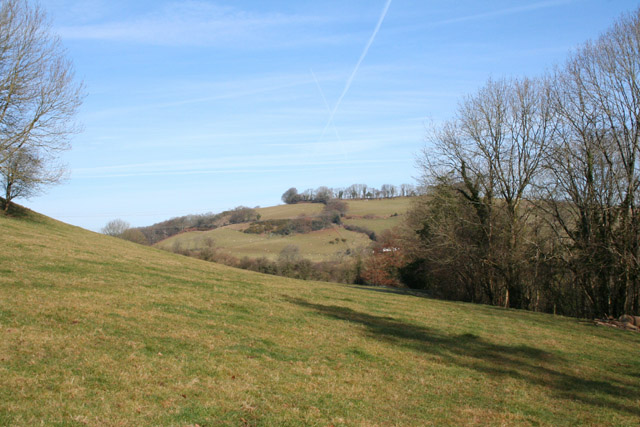
Castle Copse is a picturesque woodland located in Somerset, England. Situated near the village of Castle Cary, the copse covers an area of approximately 50 acres. It is known for its diverse range of trees and wildlife, making it a popular destination for nature enthusiasts and hikers.

The woodland is primarily composed of native tree species, including oak, beech, and ash. These majestic trees provide a dense canopy, creating a shaded and tranquil atmosphere within the copse. Sunlight filters through the leaves, casting enchanting patterns on the forest floor.

Castle Copse is home to a rich variety of wildlife. Birdwatchers can spot numerous species, such as woodpeckers, owls, and warblers. Small mammals like squirrels and rabbits can also be seen darting through the undergrowth. Additionally, the copse supports a thriving insect population, attracting butterflies and dragonflies.

Trails wind through Castle Copse, allowing visitors to explore its natural beauty. The paths meander through the woodland, offering glimpses of wildflowers and ferns that flourish on the forest floor. The copse also features a small stream, which adds to the serene ambiance as it trickles over rocks.

The copse is open to the public year-round and is a popular spot for picnics and family outings. Visitors are encouraged to respect the natural environment and adhere to designated pathways to preserve the delicate ecosystem within Castle Copse.

If you have any feedback on the listing, please let us know in the comments section below.

Castle Copse Images

Images are sourced within 2km of 51.012131/-3.3495613 or Grid Reference ST0524. Thanks to Geograph Open Source API. All images are credited.

Bathealton : Grassy Field Looking across the countryside.
Bathealton : Grassy Field
Looking across the countryside.
Bathealton : Countryside Scenery Looking across the countryside.
Bathealton : Countryside Scenery
Looking across the countryside.
Bathealton : Countryside Scenery Looking across the countryside.
Bathealton : Countryside Scenery
Looking across the countryside.
Bathealton : Grassy Field Looking across the countryside.
Bathealton : Grassy Field
Looking across the countryside.
Bathealton : Grassy Field Looking across the countryside.
Bathealton : Grassy Field
Looking across the countryside.
Bathealton : Grassy Field A grassy field with a right of way through it.
Bathealton : Grassy Field
A grassy field with a right of way through it.
Bathealton : Grassy Field A field with a tree.
Bathealton : Grassy Field
A field with a tree.
Bathealton : Pyncombe Lane Looking along Pyncombe Lane.
Bathealton : Pyncombe Lane
Looking along Pyncombe Lane.
Bathealton : Pyncombe Farm Looking along Pyncombe Lane.
Bathealton : Pyncombe Farm
Looking along Pyncombe Lane.
Chipstable: south east to the Wellington Monument Seen from a point a little south west of Champion Cross. The National Grid line runs from Taunton towards South Molton
Chipstable: south east to the Wellington Monument
Seen from a point a little south west of Champion Cross. The National Grid line runs from Taunton towards South Molton
Bathealton: Hurstone Local Nature Reserve A field in the process of being restored to pasture – part is still an orchard. It is now part of a circular walk of a little under half a mile by the banks of the river Tone and a disused railway. A small car park at the entrance to the reserve is at ST054247, by Pouch Bridge. Managed by Taunton Deane Borough Council
Bathealton: Hurstone Local Nature Reserve
A field in the process of being restored to pasture – part is still an orchard. It is now part of a circular walk of a little under half a mile by the banks of the river Tone and a disused railway. A small car park at the entrance to the reserve is at ST054247, by Pouch Bridge. Managed by Taunton Deane Borough Council
Bathealton: disused railway Track of the Taunton-Barnstaple railway, opened in November 1873 and closed in the 1960s. Looking east in the direction of Bathealton Tunnel, Wiveliscombe and Taunton
Bathealton: disused railway
Track of the Taunton-Barnstaple railway, opened in November 1873 and closed in the 1960s. Looking east in the direction of Bathealton Tunnel, Wiveliscombe and Taunton
Bathealton: road junction The right turn leads to Waterrow; left to Hurstone Local Nature Reserve and the A361 to Shillingford and Bampton
Bathealton: road junction
The right turn leads to Waterrow; left to Hurstone Local Nature Reserve and the A361 to Shillingford and Bampton
Chipstable: Waterrow A hamlet in the Tone valley with at least two active watermills in the 19th century. Now probably best known for the Rock Inn by the A361 Taunton-Bampton road. Looking north west from the bridge over the Tone
Chipstable: Waterrow
A hamlet in the Tone valley with at least two active watermills in the 19th century. Now probably best known for the Rock Inn by the A361 Taunton-Bampton road. Looking north west from the bridge over the Tone
Stawley: St Michael’s Church Robin Bush, who wrote ‘Somerset, The Complete Guide’ [The Dovecote Press, 1994], regards Stawley church as one of his favourites. It stands somewhat remote above the valley of the river Tone. Looking north
Stawley: St Michael’s Church
Robin Bush, who wrote ‘Somerset, The Complete Guide’ [The Dovecote Press, 1994], regards Stawley church as one of his favourites. It stands somewhat remote above the valley of the river Tone. Looking north
Ashbrittle: in the Tone valley On the West Deane Way, below Hagley Wood and looking north towards
Hagley Bridge. The West Deane Way is a 45-mile circular walk – details from Somerset County Council.
Ashbrittle: in the Tone valley
On the West Deane Way, below Hagley Wood and looking north towards Hagley Bridge. The West Deane Way is a 45-mile circular walk – details from Somerset County Council.
Ashbrittle: Pockeridge Bottom Seen from the lane between Combe and Norman’s Farm. Looking east
Ashbrittle: Pockeridge Bottom
Seen from the lane between Combe and Norman’s Farm. Looking east
Bathealton: Bickling’s Close Lane The view south
Bathealton: Bickling’s Close Lane
The view south
Show me another place!

Castle Copse is located at Grid Ref: ST0524 (Lat: 51.012131, Lng: -3.3495613)

Administrative County: Somerset

District: Somerset West and Taunton

Police Authority: Avon and Somerset

What 3 Words

///vaulting.walkway.traders. Near Wiveliscombe, Somerset

Related Wikis

Castles Camp

Castles Camp is a univallate Iron Age hill fort in the Taunton Deane district of Somerset, England. The hill fort is situated approximately 1 mile (1.6...

Stawley

Stawley is a village and civil parish in Somerset, England, situated 10 miles (16.1 km) west of Taunton. The parish has a population of 279 and includes...

Bathealton Court

Bathealton Court is a Grade II listed country house in Bathealton, Somerset, England. It was built in around 1766 and underwent significant alteration...

Bathealton

Bathealton is a village and civil parish in Somerset, England, situated 3 miles (4.8 km) west of Wellington and 8 miles (12.9 km) west of Taunton. The...

St Bartholomew's Church, Bathealton

St Bartholomew's Church is a Church of England parish church in Bathealton, Somerset, England. It was built in 1854 to the designs of C. E. Giles and is...

Hill Farm, Stawley

Hill Farm in Stawley, Somerset, England was built in the late 16th century. It is a Grade II* listed building. == History == The farmhouse was built in...

Chipstable

Chipstable is a village and civil parish in Somerset, England, situated beside Heydon Hill 10 miles (16.1 km) west of Taunton. The parish has a population...

Church of All Saints, Chipstable

The Church of All Saints is an Anglican church in Chipstable, Somerset, England which probably dates from the early 13th century. It is located in the...

Nearby Amenities

Located within 500m of 51.012131,-3.3495613
Give Way
Direction: backward
Lat/Long: 51.0149169/-3.3539708
Boucher's Cross
Junction: yes
Lat/Long: 51.014946/-3.3539985
Waterrow Touring Park
Source: ACSI
Tourism: camp_site
Lat/Long: 51.01556/-3.3525
Direction: backward
Maxspeed: 30 mph
Maxspeed Type: GB:nsl_restricted
Source Maxspeed: sign
Traffic Sign: maxspeed
Lat/Long: 51.0148481/-3.3539119
The data included in this document is from www.openstreetmap.org. The data is made available under ODbL.

Have you been to Castle Copse?

Leave your review of Castle Copse below (or comments, questions and feedback).