Claybrooke Magna

Settlement in Leicestershire Harborough

England

Claybrooke Magna

The Swan public house, Ullesthorpe
The Swan public house, Ullesthorpe Credit: Ian S

Claybrooke Magna is a small village located in the Harborough district of Leicestershire, England. Situated about 10 miles east of Hinckley, it is nestled in the picturesque countryside of the East Midlands region. The village is part of the wider parish of Claybrooke Parva and Magna.

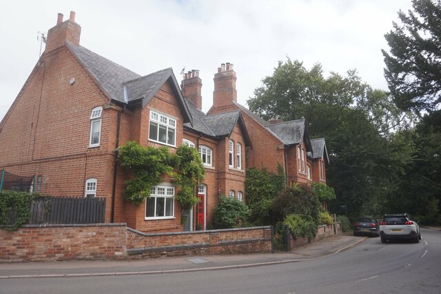
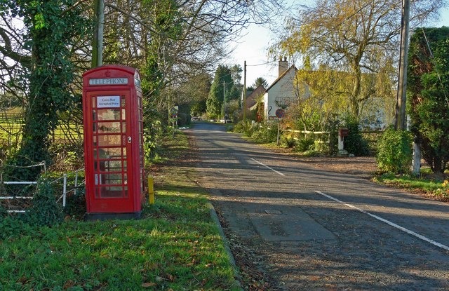
With a population of just over 200 residents, Claybrooke Magna boasts a tight-knit and friendly community. The village is known for its peaceful and idyllic setting, surrounded by farmland and green fields. It offers a tranquil escape from the hustle and bustle of city life.

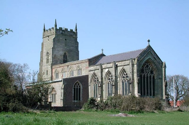
The heart of the village is centered around All Saints Church, a beautiful medieval church that dates back to the 14th century. The church serves as a place of worship for local residents and also attracts visitors with its stunning architecture and historical significance.

Claybrooke Magna is well-connected to nearby towns and cities. The A5 road runs nearby, providing easy access to major transport links. The village also benefits from a regular bus service, allowing residents to easily travel to neighboring areas.

Amenities in Claybrooke Magna are limited, with no shops or pubs within the village itself. However, there are several amenities available in nearby towns such as Lutterworth and Hinckley. These include shops, supermarkets, schools, and healthcare facilities.

Overall, Claybrooke Magna offers a peaceful and charming rural lifestyle, making it an attractive place to live for those seeking a close-knit community and a tranquil environment.

If you have any feedback on the listing, please let us know in the comments section below.

Claybrooke Magna Images

Images are sourced within 2km of 52.495439/-1.280659 or Grid Reference SP4888. Thanks to Geograph Open Source API. All images are credited.

The Swan public house, Ullesthorpe
St Peter's Church, Claybrooke Parva
Houses on Main Street, Claybrooke Parva
Main Road, Claybrooke Magna
Village Hall, Main Street, Claybrooke Magna
The Pig in Muck public house, Claybrooke Magna
Manor Road, Claybrooke Magna
Manor Close off Manor Road, Claybrooke Magna
Bumblebee Lane off High Cross Road
Entrance to High Cross Quarry
Manor Road, Claybrooke Magna With the car park of the Pig in Muck pub on the right.
Manor Road, Claybrooke Magna
With the car park of the Pig in Muck pub on the right.
High Cross Road west of Claybrooke Magna Seen from its junction with Manor Road (right) on the western edge of the village.
High Cross Road west of Claybrooke Magna
Seen from its junction with Manor Road (right) on the western edge of the village.
Frolesworth Lane, Claybrooke Magna
Laurel Fields, Claybrooke Magna Off Main Road.
Laurel Fields, Claybrooke Magna
Off Main Road.
Claybrooke Magna Village Hall Fronting onto Main Road.
Claybrooke Magna Village Hall
Fronting onto Main Road.
Fosse Way Gardens, Claybrooke Magna Off Main Road.
Fosse Way Gardens, Claybrooke Magna
Off Main Road.
Main Road, Claybrooke Magna
Show me another place!

Claybrooke Magna is located at Grid Ref: SP4888 (Lat: 52.495439, Lng: -1.280659)

Administrative County: Leicestershire

District: Harborough

Police Authority: Leicestershire

What 3 Words

///airliners.excusing.digress. Near Sapcote, Leicestershire

Nearby Locations

Claybrooke Magna

Related Wikis

Claybrooke Magna

Claybrooke Magna is a village and civil parish in the Harborough district of Leicestershire, England, close to the A5 trunk road. The village is located...

High Cross, Leicestershire

High Cross is the name given to the crossroads of the Roman roads of Watling Street and Fosse Way in Leicestershire, England. It is about a mile west of...

Claybrooke Parva

Claybrooke Parva is a village and civil parish in the Harborough district south west Leicestershire, England close to Claybrooke Magna. The village is...

Wibtoft

Wibtoft is a small village and civil parish in north-eastern Warwickshire, England. The village was originally within the civil parish of Claybrooke Magna...

Nearby Amenities

Located within 500m of 52.495439,-1.280659
Claybrooke Magna
Created By: Potlatch 0.10c
Place: village
Lat/Long: 52.4936869/-1.2752805
Pub
Pig in Muck
Addr City: Lutterworth
Addr Country: GB
Addr Postcode: LE17 5AY
Addr Street: Manor Road
Addr Village: Claybrooke Magna
Fhrs Authority: Harborough
Fhrs Id: 369073
Fhrs Local Authority Id: 10310/2003/2/000
Lat/Long: 52.4956325/-1.2804966
Bus Stop
The Laurels
Bus: yes
Naptan AtcoCode: 260018400
Naptan Bearing: SE
Naptan CommonName: The Laurels
Naptan Indicator: before
Naptan Landmark: The Laurels
Naptan NaptanCode: leijmdgp
Naptan Notes: Hourly - County
Naptan Street: Main Road
Naptan Verified: no
Public Transport: platform
Source: naptan_import
Lat/Long: 52.4950101/-1.2789111
Bus Stop
The Laurels
Bus: yes
Naptan AtcoCode: 260018401
Naptan Bearing: NW
Naptan CommonName: The Laurels
Naptan Indicator: opposite
Naptan Landmark: The Laurels
Naptan NaptanCode: leijmdgt
Naptan Notes: Hourly - County
Naptan Street: Main Road
Naptan Verified: no
Public Transport: platform
Source: naptan_import
Lat/Long: 52.494803/-1.2788703
Bus Stop
Bell Street
Bus: yes
Naptan AtcoCode: 260018402
Naptan Bearing: N
Naptan CommonName: Bell Street
Naptan Indicator: opposite
Naptan Landmark: Bell Street
Naptan NaptanCode: leijmdgw
Naptan Notes: Hourly - County
Naptan Street: Main Road
Naptan Verified: no
Public Transport: platform
Source: naptan_import
Lat/Long: 52.4928912/-1.2764271
Bus Stop
Bell Street
Bus: yes
Naptan AtcoCode: 260018403
Naptan Bearing: S
Naptan CommonName: Bell Street
Naptan Indicator: adjacent
Naptan Landmark: Bell Street
Naptan NaptanCode: leijmdja
Naptan Notes: Hourly - County
Naptan Street: Main Road
Naptan Verified: no
Public Transport: platform
Source: naptan_import
Lat/Long: 52.4928181/-1.2762368
Place: farm
Lat/Long: 52.4962459/-1.2787646
Generator Method: photovoltaic
Generator Output Electricity: yes
Generator Source: solar
Generator Type: solar_photovoltaic_panel
Location: roof
Power: generator
Lat/Long: 52.4968659/-1.2807587
Generator Method: photovoltaic
Generator Output Electricity: yes
Generator Source: solar
Generator Type: solar_photovoltaic_panel
Location: roof
Power: generator
Lat/Long: 52.4967597/-1.2816036
Generator Method: photovoltaic
Generator Output Electricity: yes
Generator Source: solar
Generator Type: solar_photovoltaic_panel
Location: roof
Power: generator
Lat/Long: 52.4954321/-1.2774596
Generator Method: photovoltaic
Generator Output Electricity: yes
Generator Source: solar
Generator Type: solar_photovoltaic_panel
Location: roof
Power: generator
Lat/Long: 52.4954653/-1.2743469
Generator Method: photovoltaic
Generator Output Electricity: yes
Generator Source: solar
Generator Type: solar_photovoltaic_panel
Location: roof
Power: generator
Lat/Long: 52.4936159/-1.2741686
The data included in this document is from www.openstreetmap.org. The data is made available under ODbL.

Have you been to Claybrooke Magna?

Leave your review of Claybrooke Magna below (or comments, questions and feedback).