Daccombe Brake

Wood, Forest in Devon Teignbridge

England

Daccombe Brake

Pussy willow, Brown's Bridge Looking along the railway line towards Torre from Brown's Bridge, with Salix caprea (Goat Willow) overhanging the line.
Pussy willow, Brown's Bridge Credit: Derek Harper

Daccombe Brake is a woodland area located in Devon, England. Covering an area of approximately 60 hectares, it is situated near the village of Daccombe, about 4 miles west of the coastal town of Torquay. The woodland is part of the broader landscape of the South Devon Area of Outstanding Natural Beauty.

Daccombe Brake is primarily composed of mixed deciduous trees, including oak, beech, and birch, creating a diverse and vibrant woodland habitat. The forest floor is carpeted with a variety of wildflowers, such as bluebells and primroses, adding a splash of color during the spring and summer months.

The woodland is crisscrossed by a network of footpaths and trails, allowing visitors to explore the area and enjoy the natural beauty it has to offer. These paths provide access to the different parts of the woodland, including a small stream that meanders through the trees, adding to the overall tranquility of the environment.

Daccombe Brake is home to a rich diversity of wildlife, including various bird species, squirrels, and deer. The woodland provides an important habitat for these animals, offering shelter, food, and breeding grounds. Birdwatchers in particular may be rewarded with sightings of species such as the great spotted woodpecker and the tawny owl.

Overall, Daccombe Brake is a picturesque woodland in Devon, offering visitors the opportunity to connect with nature, explore its trails, and appreciate the beauty and biodiversity of this natural environment.

If you have any feedback on the listing, please let us know in the comments section below.

Daccombe Brake Images

Images are sourced within 2km of 50.500607/-3.545154 or Grid Reference SX9067. Thanks to Geograph Open Source API. All images are credited.

Pussy willow, Brown's Bridge Looking along the railway line towards Torre from Brown's Bridge, with Salix caprea (Goat Willow) overhanging the line.
Pussy willow, Brown's Bridge
Looking along the railway line towards Torre from Brown's Bridge, with Salix caprea (Goat Willow) overhanging the line.
Pruned trees, The Willows An area of trees and bushes beside the steps and path connecting Wren Park to The Willows has been drastically cut back, allowing a clearer view of the car park should one wish for such a thing. On the right is the corner of Marks & Spencer.
Pruned trees, The Willows
An area of trees and bushes beside the steps and path connecting Wren Park to The Willows has been drastically cut back, allowing a clearer view of the car park should one wish for such a thing. On the right is the corner of Marks & Spencer.
Comfrey and trolley, The Willows Comfrey growing by a remnant of natural(-ish) woodland beside Nicholson Road. The road is used instead of the car park for parking for Sainsbury's and there is no trolley point, with the result that many lazy shoppers leave trolleys alongside. Are they totally nuts?
Comfrey and trolley, The Willows
Comfrey growing by a remnant of natural(-ish) woodland beside Nicholson Road. The road is used instead of the car park for parking for Sainsbury's and there is no trolley point, with the result that many lazy shoppers leave trolleys alongside. Are they totally nuts?
Sainsbury's, The Willows <a href="https://www.geograph.org.uk/photo/2250825">SX8966 : Supermarket by night</a> by day. Note the way shoppers must cross a through exit road to enter the store.
Sainsbury's, The Willows
SX8966 : Supermarket by night by day. Note the way shoppers must cross a through exit road to enter the store.
Roses, Riviera Way Wild roses blooming and losing their petals by the A3022 dual carriageway.
Roses, Riviera Way
Wild roses blooming and losing their petals by the A3022 dual carriageway.
Formerly flooded area at the Willows, Torquay Another view of <a href="https://www.geograph.org.uk/photo/1562179">SX8966 : Formerly flooded area at the Willows, Torquay</a>, which is now knee-deep in mint and smelling unexpectedly pleasant; I was expecting stagnant water and traffic fumes.
Formerly flooded area at the Willows, Torquay
Another view of SX8966 : Formerly flooded area at the Willows, Torquay, which is now knee-deep in mint and smelling unexpectedly pleasant; I was expecting stagnant water and traffic fumes.
Walkway, The Willows Taken from approximately the same spot as <a href="https://www.geograph.org.uk/photo/2092042">SX8966 : Walkway, The Willows</a> and a reverse view of <a href="https://www.geograph.org.uk/photo/1777969">SX8966 : Path at The Willows</a>.
Walkway, The Willows
Taken from approximately the same spot as SX8966 : Walkway, The Willows and a reverse view of SX8966 : Path at The Willows.
Sainsbury's, Torquay A view from Nicholson Road. On the left is the wooded area shown in <a href="https://www.geograph.org.uk/photo/335597">SX8966 : Path through the ivy</a>.
Sainsbury's, Torquay
A view from Nicholson Road. On the left is the wooded area shown in SX8966 : Path through the ivy.
Signs on Fluder Hill Speed limit signs at the start of Kingskerswell, near the top of Fluder Hill. There are some hefty speed humps on this road to encourage you to keep to the 20 mph limit.
Signs on Fluder Hill
Speed limit signs at the start of Kingskerswell, near the top of Fluder Hill. There are some hefty speed humps on this road to encourage you to keep to the 20 mph limit.
Field access track, Fluder Hill From roughly the same point as <a href="https://www.geograph.org.uk/photo/2671274">SX8867 : Signs on Fluder Hill</a> and <a href="https://www.geograph.org.uk/photo/2671484">SX8867 : Southern Kingskerswell</a>, looking down this green lane which runs for nearly 300 metres giving access to several fields, petering out in one of them.
Field access track, Fluder Hill
From roughly the same point as SX8867 : Signs on Fluder Hill and SX8867 : Southern Kingskerswell, looking down this green lane which runs for nearly 300 metres giving access to several fields, petering out in one of them.
Kingskerswell Road This steep lane climbs from Scott's Bridge to Kingskerswell Cross.
Kingskerswell Road
This steep lane climbs from Scott's Bridge to Kingskerswell Cross.
Lidl, Torquay A pair of learner scooters outside the Torquay branch of the supermarket. Why no baskets?
Lidl, Torquay
A pair of learner scooters outside the Torquay branch of the supermarket. Why no baskets?
Oak leaves, The Willows Rich brown turkey oak leaves cling on in the car park at The Willows after much rain and wind.
Oak leaves, The Willows
Rich brown turkey oak leaves cling on in the car park at The Willows after much rain and wind.
Bridleway, Welsury Covert Approaching the junction shown in <a href="https://www.geograph.org.uk/photo/2078426">SX8966 : Tracks in Welsury Covert</a>. I wonder if this section of the bridleway will receive the same treatment as the stretch south of Browns Bridge Road, shown in <a href="https://www.geograph.org.uk/photo/2735261">SX9066 : Bridleway near Wren Park</a>.
Bridleway, Welsury Covert
Approaching the junction shown in SX8966 : Tracks in Welsury Covert. I wonder if this section of the bridleway will receive the same treatment as the stretch south of Browns Bridge Road, shown in SX9066 : Bridleway near Wren Park.
Mazda, Torquay One of a row of car showrooms along Newton Road on the fringe of Torquay.
Mazda, Torquay
One of a row of car showrooms along Newton Road on the fringe of Torquay.
Bus stop on Riviera Way near The Willows shopping centre
Marks & Spencer's, The Willows, Torquay Another view of <a href="https://www.geograph.org.uk/photo/1446063">SX8966 : Marks & Spencer store</a>, which fairly recently acquired an upper storey.
Marks & Spencer's, The Willows, Torquay
Another view of SX8966 : Marks & Spencer store, which fairly recently acquired an upper storey.
Track near Brown's Bridge A track up the side of a small valley passes a tree. This is close to the site where Sainsbury's at The Willows now stands.
Track near Brown's Bridge
A track up the side of a small valley passes a tree. This is close to the site where Sainsbury's at The Willows now stands.
Show me another place!

Daccombe Brake is located at Grid Ref: SX9067 (Lat: 50.500607, Lng: -3.545154)

Administrative County: Devon

District: Teignbridge

Police Authority: Devon and Cornwall

What 3 Words

///useful.scrubber.dangerously. Near Kingskerswell, Devon

Nearby Locations

Daccombe Brake Barton

Related Wikis

Brunel Manor

Brunel Manor, previously known as Watcombe Park, is a mansion on the outskirts of the seaside resort of Torquay, Devon, England. == Ownership history... ==

Coffinswell

Coffinswell is a small village in South Devon, England, just off the A380, the busy Newton Abbot to Torquay road. It lies within Teignbridge District Council...

Combe Pafford

Combe Pafford is a village in Torbay in the English county of Devon. == References ==

Edginswell railway station

Torquay Gateway railway station is a proposed station in the Edginswell area of Torquay, Devon. The station would be located on the Riviera Line between...
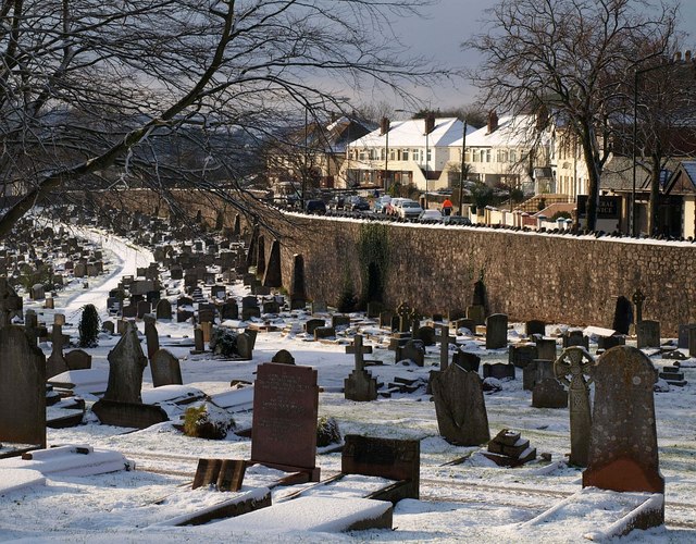
Torquay Cemetery

Torquay Cemetery, also known as Barton Road Cemetery is a burial ground located in the town of Torquay, Devon, England. The first interment, which took...

Devon Studio School

Devon Studio school was a Studio school and 6th form for boys and girls, located on Newton Road in Torquay, Devon, England in the grounds of Torbay Hospital...

Kingskerswell

Kingskerswell (formerly Kings Carswell, or Kings Kerswell) is a village and civil parish within Teignbridge local government district in the south of Devon...

Milber Down

Milber Down is an Iron Age hill fort on the hill above the suburb of Milber, Newton Abbot in Devon, England. The fort is situated on the north-western...

Nearby Amenities

Located within 500m of 50.500607,-3.545154
Daccombe
Is In: Devon, England, UK
Place: hamlet
Lat/Long: 50.5017938/-3.5500558
Barrier: stile
Lat/Long: 50.5021137/-3.5388983
Daccombe Cross
Place: locality
Lat/Long: 50.5019869/-3.5500139
Post Box
Brand: Royal Mail
Brand Wikidata: Q638098
Brand Wikipedia: en:Royal Mail
Collection Times: Mo-Fr 09:00; Sa 07:00; Su off
Operator: Royal Mail
Operator Wikidata: Q638098
Post Box Mounting: telegraph_pole
Post Box Type: lamp
Ref: TQ12 159D
Royal Cypher: EIIR
Royal Cypher Wikidata: Q33102113
Source: survey;streetlevel imagery;aerial imagery
Lat/Long: 50.5018234/-3.5496135
Noexit: yes
Lat/Long: 50.4993394/-3.5413945
Post Box
Brand: Royal Mail
Brand Wikidata: Q638098
Brand Wikipedia: en:Royal Mail
Collection Times: Mo-Fr 09:00; Sa 07:00; Su off
Operator: Royal Mail
Operator Wikidata: Q638098
Post Box Design: 2010_pattern
Post Box Mounting: pier
Post Box Type: lamp
Postal Code: TQ2
Ref: TQ2 207D
Royal Cypher: EIIR
Royal Cypher Wikidata: Q33102113
Source: survey;streetlevel imagery;aerial imagery
Lat/Long: 50.4967525/-3.5426155
Barrier: cycle_barrier
Lat/Long: 50.4994285/-3.5418726
Generator Method: photovoltaic
Generator Output Electricity: yes
Generator Source: solar
Generator Type: solar_photovoltaic_panel
Location: roof
Power: generator
Lat/Long: 50.5011131/-3.5517501
Generator Method: photovoltaic
Generator Output Electricity: yes
Generator Source: solar
Generator Type: solar_photovoltaic_panel
Location: roof
Power: generator
Lat/Long: 50.5017102/-3.5494005
Generator Method: photovoltaic
Generator Output Electricity: yes
Generator Source: solar
Generator Type: solar_photovoltaic_panel
Location: roof
Power: generator
Lat/Long: 50.4996561/-3.5491404
Generator Method: photovoltaic
Generator Output Electricity: yes
Generator Source: solar
Generator Type: solar_photovoltaic_panel
Location: roof
Power: generator
Lat/Long: 50.4994664/-3.5386049
Generator Method: photovoltaic
Generator Output Electricity: yes
Generator Source: solar
Generator Type: solar_photovoltaic_panel
Location: roof
Power: generator
Lat/Long: 50.4994374/-3.5385512
Generator Method: photovoltaic
Generator Output Electricity: yes
Generator Source: solar
Generator Type: solar_photovoltaic_panel
Location: roof
Power: generator
Lat/Long: 50.4994135/-3.5384922
Generator Method: photovoltaic
Generator Output Electricity: yes
Generator Source: solar
Generator Type: solar_photovoltaic_panel
Location: roof
Power: generator
Lat/Long: 50.5004179/-3.5388489
Generator Method: photovoltaic
Generator Output Electricity: yes
Generator Source: solar
Generator Type: solar_photovoltaic_panel
Location: roof
Power: generator
Lat/Long: 50.5006465/-3.5398011
Generator Method: photovoltaic
Generator Output Electricity: yes
Generator Source: solar
Generator Type: solar_photovoltaic_panel
Location: roof
Power: generator
Lat/Long: 50.5006738/-3.5398467
Generator Method: photovoltaic
Generator Output Electricity: yes
Generator Source: solar
Generator Type: solar_photovoltaic_panel
Location: roof
Power: generator
Lat/Long: 50.5001808/-3.5412442
Generator Method: photovoltaic
Generator Output Electricity: yes
Generator Source: solar
Generator Type: solar_photovoltaic_panel
Location: roof
Power: generator
Lat/Long: 50.5001893/-3.5411744
Generator Method: photovoltaic
Generator Output Electricity: yes
Generator Source: solar
Generator Type: solar_photovoltaic_panel
Location: roof
Power: generator
Lat/Long: 50.500046/-3.5412978
Generator Method: photovoltaic
Generator Output Electricity: yes
Generator Source: solar
Generator Type: solar_photovoltaic_panel
Location: roof
Power: generator
Lat/Long: 50.5000528/-3.5414078
Generator Method: photovoltaic
Generator Output Electricity: yes
Generator Source: solar
Generator Type: solar_photovoltaic_panel
Location: roof
Power: generator
Lat/Long: 50.4988671/-3.5403778
Generator Method: photovoltaic
Generator Output Electricity: yes
Generator Source: solar
Generator Type: solar_photovoltaic_panel
Location: roof
Power: generator
Lat/Long: 50.4983351/-3.5414882
Generator Method: photovoltaic
Generator Output Electricity: yes
Generator Source: solar
Generator Type: solar_photovoltaic_panel
Location: roof
Power: generator
Lat/Long: 50.4984852/-3.5420998
Generator Method: photovoltaic
Generator Output Electricity: yes
Generator Source: solar
Generator Type: solar_photovoltaic_panel
Location: roof
Power: generator
Lat/Long: 50.4996773/-3.5406366
Generator Method: photovoltaic
Generator Output Electricity: yes
Generator Source: solar
Generator Type: solar_photovoltaic_panel
Location: roof
Power: generator
Lat/Long: 50.4996833/-3.5405776
Direction: SSE
Generator Method: photovoltaic
Generator Output Electricity: yes
Generator Solar Modules: 6
Generator Source: solar
Generator Type: solar_photovoltaic_panel
Location: roof
Power: generator
Lat/Long: 50.4968687/-3.541701
Generator Method: photovoltaic
Generator Output Electricity: yes
Generator Source: solar
Generator Type: solar_photovoltaic_panel
Location: roof
Power: generator
Lat/Long: 50.4988618/-3.5403746
Direction: SSE
Generator Method: photovoltaic
Generator Output Electricity: yes
Generator Solar Modules: 6
Generator Source: solar
Generator Type: solar_photovoltaic_panel
Location: roof
Power: generator
Lat/Long: 50.4968902/-3.5415558
Generator Method: photovoltaic
Generator Output Electricity: yes
Generator Source: solar
Generator Type: solar_photovoltaic_panel
Location: roof
Power: generator
Lat/Long: 50.5012452/-3.5400224
Post Box
Brand: Royal Mail
Brand Wikidata: Q638098
Brand Wikipedia: en:Royal Mail
Collection Times: Mo-Fr 09:00; Sa 07:00; Su off
Operator: Royal Mail
Operator Wikidata: Q638098
Post Box Design: type_b
Post Box Mounting: brick_pillar
Post Box Type: wall
Ref: TQ2 369D
Royal Cypher: EIIR
Royal Cypher Wikidata: Q33102113
Source: survey;streetlevel imagery;aerial imagery
Lat/Long: 50.4983633/-3.5390912
The data included in this document is from www.openstreetmap.org. The data is made available under ODbL.

Have you been to Daccombe Brake?

Leave your review of Daccombe Brake below (or comments, questions and feedback).