Bigburrow Plantation

Wood, Forest in Somerset Somerset West and Taunton

England

Bigburrow Plantation

Road fork at Langdon's Way
Road fork at Langdon's Way Credit: David Smith

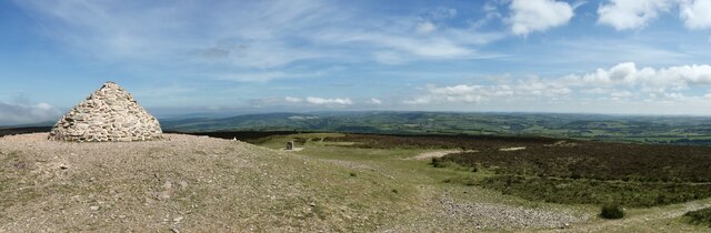
Bigburrow Plantation is a sprawling woodland located in Somerset, England. Covering an area of approximately 500 acres, this plantation is renowned for its stunning beauty and rich biodiversity. Situated amidst the picturesque countryside, it offers a peaceful retreat for nature lovers and outdoor enthusiasts.

The woodland is primarily composed of ancient broadleaf trees, including oak, birch, and beech, which create a dense canopy that provides shade and shelter for various plant and animal species. The forest floor is adorned with a myriad of wildflowers, including bluebells, primroses, and foxgloves, adding to the area's natural charm.

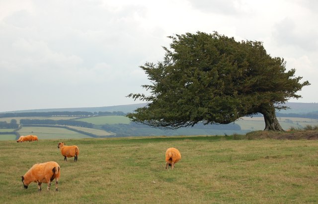
Bigburrow Plantation is also home to a diverse range of wildlife. Birdwatchers can spot a variety of species, such as woodpeckers, owls, and finches, while mammal enthusiasts may encounter deer, squirrels, and foxes. The woodland's tranquil atmosphere is occasionally interrupted by the enchanting songs of birds and the rustling of leaves, offering visitors a truly immersive experience in nature.

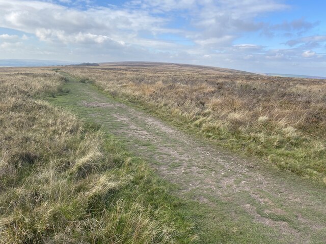
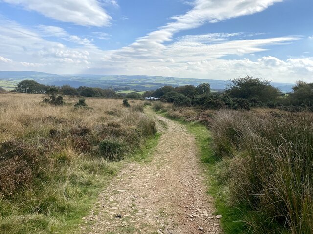
The plantation boasts a network of well-maintained walking trails, allowing visitors to explore the woodland at their own pace. These trails wind through the forest, offering breathtaking views and opportunities to observe the local flora and fauna. Additionally, picnic areas and benches are scattered throughout the plantation, providing visitors with the perfect spots to relax and soak in the natural surroundings.

Bigburrow Plantation is not only a haven for nature enthusiasts but also plays an important role in conservation efforts. The woodland is managed sustainably, ensuring the preservation of its unique ecosystem for future generations to enjoy. With its stunning landscapes and diverse wildlife, Bigburrow Plantation is a true gem in the heart of Somerset's countryside.

If you have any feedback on the listing, please let us know in the comments section below.

Bigburrow Plantation Images

Images are sourced within 2km of 51.147542/-3.5972175 or Grid Reference SS8839. Thanks to Geograph Open Source API. All images are credited.

Road fork at Langdon's Way
Hedge and ditch by B3224 Land around this road has been reclaimed from marshland, so the ditch is probably a reminder of that
Hedge and ditch by B3224
Land around this road has been reclaimed from marshland, so the ditch is probably a reminder of that
Hegebank by B3224
Hegebank by B3224
Dunkery Beacon Dunkery Beacon on Exmoor, with the view of the Brendon Hills and more distant Quantock Hills behind.
Dunkery Beacon
Dunkery Beacon on Exmoor, with the view of the Brendon Hills and more distant Quantock Hills behind.
Moorland track, west of Dunkery Beacon
Dunkery Beacon At 519m the highest point on Exmoor.
Dunkery Beacon
At 519m the highest point on Exmoor.
Bridleway to Dunkery Bridge
Cutcombe : Exmoor - Dunkery Beacon I headed up to Dunkery Beacon on a clear September evening to see if I could see the stars and the Milky Way, after all, they do say this is a good spot for it. Got to the top, and soon after two other chaps were doing the same thing. One of them had a red light on his hat, it illuminated the beacon. He (Farmer Torque), wanted to get a nice shot of him looking at the stars.
Cutcombe : Exmoor - Dunkery Beacon
I headed up to Dunkery Beacon on a clear September evening to see if I could see the stars and the Milky Way, after all, they do say this is a good spot for it. Got to the top, and soon after two other chaps were doing the same thing. One of them had a red light on his hat, it illuminated the beacon. He (Farmer Torque), wanted to get a nice shot of him looking at the stars.
Cutcombe : Exmoor - Dunkery Beacon A man is taking photographs of the night sky.
Cutcombe : Exmoor - Dunkery Beacon
A man is taking photographs of the night sky.
Cutcombe : Exmoor - Moorland Scenery The Moon has come into view over the Bristol Channel.
Cutcombe : Exmoor - Moorland Scenery
The Moon has come into view over the Bristol Channel.
Cutcombe : Exmoor - Moorland Scenery Looking down the moorland from Dunkery Beacon and across the Bristol Channel where the lights of South Wales glow.
Cutcombe : Exmoor - Moorland Scenery
Looking down the moorland from Dunkery Beacon and across the Bristol Channel where the lights of South Wales glow.
Cutcombe : Exmoor - Dunkery Beacon Looking towards Dunkery Beacon with the many stars seen in the sky, including the white glow of the Milky Way.
Cutcombe : Exmoor - Dunkery Beacon
Looking towards Dunkery Beacon with the many stars seen in the sky, including the white glow of the Milky Way.
Cutcombe : Exmoor - Moorland Scenery From the top of Dunkery Beacon, looking into the night sky with the Milky Way in view.
Cutcombe : Exmoor - Moorland Scenery
From the top of Dunkery Beacon, looking into the night sky with the Milky Way in view.
Cutcombe : Exmoor - Dunkery Beacon Looking across Exmoor from the top of Dunkery Beacon, with the Milky Way in view.
Cutcombe : Exmoor - Dunkery Beacon
Looking across Exmoor from the top of Dunkery Beacon, with the Milky Way in view.
Sheep in a field at Long Lane Head Near to Dunkery Gate.
Sheep in a field at Long Lane Head
Near to Dunkery Gate.
Bridleway to Codsend This part of the route marked as (Holloway Lane) slopes gently down hill all the way to Codsend. It tends to get very boggy in the winter months.
Bridleway to Codsend
This part of the route marked as (Holloway Lane) slopes gently down hill all the way to Codsend. It tends to get very boggy in the winter months.
Round this bend to Codsend This is a small farming community at the end of a single road. The photograph shows the last few metres of bridleway/farm road before the start of the road.
Round this bend to Codsend
This is a small farming community at the end of a single road. The photograph shows the last few metres of bridleway/farm road before the start of the road.
Orange Flavoured Lamb on Stone Down The wind swept beech tree is clinging to the remains of a circular enclosure approx 16M diameter.
Orange Flavoured Lamb on Stone Down
The wind swept beech tree is clinging to the remains of a circular enclosure approx 16M diameter.
Show me another place!

Bigburrow Plantation is located at Grid Ref: SS8839 (Lat: 51.147542, Lng: -3.5972175)

Administrative County: Somerset

District: Somerset West and Taunton

Police Authority: Avon and Somerset

What 3 Words

///jacket.unloading.sized. Near Porlock, Somerset

Related Wikis

Dunkery Hill

Dunkery Beacon at the summit of Dunkery Hill is the highest point on Exmoor and in Somerset, England. It is also the highest point in southern England...

Sweetworthy

Sweetworthy is the site of two Iron Age hill forts or enclosures at Luccombe, 4 kilometres (2 mi) south of Porlock, Somerset, England. They are on the...

Church of St Mary Magdelene, Exford

The Anglican Church of St Mary Magdelene in Exford, Somerset, England was built in the 15th century. It is a Grade II* listed building. == History == Nothing...

Road Castle

Road Castle is an Iron Age bank and ditch in the West Somerset district of Somerset, England. The hill fort is situated approximately 2 miles (3.2 km)...

Exford, Somerset

Exford is a rural village at the centre of Exmoor National Park, 7 miles (11 km) north-west of Dulverton, and 10 miles (16 km) south-west of Minehead,...

Stoke Pero Church

Stoke Pero Church in Stoke Pero, Somerset, England was built in the 13th century. It is a Grade II* listed building. Standing 1,013 feet (309 meters) above...

Nutscale Reservoir

Nutscale Reservoir is a reservoir located in Exmoor in north west Somerset, England. It supplies the town of Minehead and nearby Porlock and Porlock Weir...

Timberscombe

Timberscombe is a village and civil parish on the River Avill 2.5 miles (4 km) south-west of Dunster, and 5.5 miles (9 km) south of Minehead within the...

Have you been to Bigburrow Plantation?

Leave your review of Bigburrow Plantation below (or comments, questions and feedback).