Gappah Brake

Wood, Forest in Devon Teignbridge

England

Gappah Brake

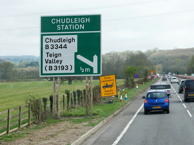
Devon Expressway, Chudleigh Station Interchange The A38 is a major A-class trunk route. When first designated in 1922, it ran from Derby to Plymouth but it was later extended at both ends so that it now runs for 292 miles from Mansfield in Nottinghamshire to Bodmin in Cornwall.

Prior to the opening of the M5 motorway in the 1960s and 1970s, the A38 formed the main "holiday route" from the Midlands to Somerset, Devon and Cornwall and the south-western section was notorious at holiday times for the congestion. Nowadays, for most of the southern section, the A38 is a fairly quiet road shadowing the M5 extremely closely; often running alongside the motorway as a single carriageway road. The section between Exeter and Plymouth is, however, a busy dual carriageway which serves as the southern extension of the M5 and is known as “the Devon Expressway”.

More information at <span class="nowrap"><a title="http://en.wikipedia.org/wiki/A38_road" rel="nofollow ugc noopener" href="http://en.wikipedia.org/wiki/A38_road">Link</a><img style="margin-left:2px;" alt="External link" title="External link - shift click to open in new window" src="https://s1.geograph.org.uk/img/external.png" width="10" height="10"/></span>  (Wikipedia) and <span class="nowrap"><a title="http://www.sabre-roads.org.uk/wiki/index.php?title=A38" rel="nofollow ugc noopener" href="http://www.sabre-roads.org.uk/wiki/index.php?title=A38">Link</a><img style="margin-left:2px;" alt="External link" title="External link - shift click to open in new window" src="https://s1.geograph.org.uk/img/external.png" width="10" height="10"/></span>  (SABRE).
Devon Expressway, Chudleigh Station Interchange Credit: David Dixon

Gappah Brake, located in Devon, England, is a beautiful woodland area known for its serene and picturesque setting. Situated in the larger region of Dartmoor National Park, this woodland is particularly notable for its dense concentration of trees, making it an ideal location for nature lovers and outdoor enthusiasts.

Covering an area of approximately 200 acres, Gappah Brake is characterized by a variety of tree species, including oak, birch, and beech trees, which create a captivating and diverse landscape. The forest floor is covered with a rich carpet of ferns, moss, and wildflowers, adding to the enchanting atmosphere.

The woodland is crisscrossed by a network of well-maintained trails, allowing visitors to explore the area easily. These trails range from leisurely strolls to more challenging hikes, catering to different fitness levels and preferences. Along the way, visitors can encounter a range of wildlife, including squirrels, rabbits, and various bird species. The forest is also home to an array of plant life, including rare orchids and ancient ferns.

Gappah Brake is a popular destination for outdoor activities such as walking, hiking, and birdwatching. The tranquil environment provides a welcome escape from the hustle and bustle of city life, offering visitors a chance to reconnect with nature. The forest is open to the public year-round, with stunning displays of autumn colors and vibrant spring blooms being particularly popular among visitors.

Overall, Gappah Brake offers a serene and captivating woodland experience, providing a peaceful retreat for nature enthusiasts and those seeking a tranquil escape in the heart of Devon.

If you have any feedback on the listing, please let us know in the comments section below.

Gappah Brake Images

Images are sourced within 2km of 50.582683/-3.6095534 or Grid Reference SX8677. Thanks to Geograph Open Source API. All images are credited.

Devon Expressway, Chudleigh Station Interchange The A38 is a major A-class trunk route. When first designated in 1922, it ran from Derby to Plymouth but it was later extended at both ends so that it now runs for 292 miles from Mansfield in Nottinghamshire to Bodmin in Cornwall.

Prior to the opening of the M5 motorway in the 1960s and 1970s, the A38 formed the main "holiday route" from the Midlands to Somerset, Devon and Cornwall and the south-western section was notorious at holiday times for the congestion. Nowadays, for most of the southern section, the A38 is a fairly quiet road shadowing the M5 extremely closely; often running alongside the motorway as a single carriageway road. The section between Exeter and Plymouth is, however, a busy dual carriageway which serves as the southern extension of the M5 and is known as “the Devon Expressway”.

More information at <span class="nowrap"><a title="http://en.wikipedia.org/wiki/A38_road" rel="nofollow ugc noopener" href="http://en.wikipedia.org/wiki/A38_road">Link</a><img style="margin-left:2px;" alt="External link" title="External link - shift click to open in new window" src="https://s1.geograph.org.uk/img/external.png" width="10" height="10"/></span>  (Wikipedia) and <span class="nowrap"><a title="http://www.sabre-roads.org.uk/wiki/index.php?title=A38" rel="nofollow ugc noopener" href="http://www.sabre-roads.org.uk/wiki/index.php?title=A38">Link</a><img style="margin-left:2px;" alt="External link" title="External link - shift click to open in new window" src="https://s1.geograph.org.uk/img/external.png" width="10" height="10"/></span>  (SABRE).
Devon Expressway, Chudleigh Station Interchange
The A38 is a major A-class trunk route. When first designated in 1922, it ran from Derby to Plymouth but it was later extended at both ends so that it now runs for 292 miles from Mansfield in Nottinghamshire to Bodmin in Cornwall. Prior to the opening of the M5 motorway in the 1960s and 1970s, the A38 formed the main "holiday route" from the Midlands to Somerset, Devon and Cornwall and the south-western section was notorious at holiday times for the congestion. Nowadays, for most of the southern section, the A38 is a fairly quiet road shadowing the M5 extremely closely; often running alongside the motorway as a single carriageway road. The section between Exeter and Plymouth is, however, a busy dual carriageway which serves as the southern extension of the M5 and is known as “the Devon Expressway”. More information at LinkExternal link (Wikipedia) and LinkExternal link (SABRE).
Eastbound A38 near Chudleigh Knighton The A38 is a major A-class trunk route. When first designated in 1922, it ran from Derby to Plymouth but it was later extended at both ends so that it now runs for 292 miles from Mansfield in Nottinghamshire to Bodmin in Cornwall.

Prior to the opening of the M5 motorway in the 1960s and 1970s, the A38 formed the main "holiday route" from the Midlands to Somerset, Devon and Cornwall and the south-western section was notorious at holiday times for the congestion. Nowadays, for most of the southern section, the A38 is a fairly quiet road shadowing the M5 extremely closely; often running alongside the motorway as a single carriageway road. The section between Exeter and Plymouth is, however, a busy dual carriageway which serves as the southern extension of the M5 and is known as “the Devon Expressway”.

More information at <span class="nowrap"><a title="http://en.wikipedia.org/wiki/A38_road" rel="nofollow ugc noopener" href="http://en.wikipedia.org/wiki/A38_road">Link</a><img style="margin-left:2px;" alt="External link" title="External link - shift click to open in new window" src="https://s1.geograph.org.uk/img/external.png" width="10" height="10"/></span>  (Wikipedia) and <span class="nowrap"><a title="http://www.sabre-roads.org.uk/wiki/index.php?title=A38" rel="nofollow ugc noopener" href="http://www.sabre-roads.org.uk/wiki/index.php?title=A38">Link</a><img style="margin-left:2px;" alt="External link" title="External link - shift click to open in new window" src="https://s1.geograph.org.uk/img/external.png" width="10" height="10"/></span>  (SABRE).
Eastbound A38 near Chudleigh Knighton
The A38 is a major A-class trunk route. When first designated in 1922, it ran from Derby to Plymouth but it was later extended at both ends so that it now runs for 292 miles from Mansfield in Nottinghamshire to Bodmin in Cornwall. Prior to the opening of the M5 motorway in the 1960s and 1970s, the A38 formed the main "holiday route" from the Midlands to Somerset, Devon and Cornwall and the south-western section was notorious at holiday times for the congestion. Nowadays, for most of the southern section, the A38 is a fairly quiet road shadowing the M5 extremely closely; often running alongside the motorway as a single carriageway road. The section between Exeter and Plymouth is, however, a busy dual carriageway which serves as the southern extension of the M5 and is known as “the Devon Expressway”. More information at LinkExternal link (Wikipedia) and LinkExternal link (SABRE).
Eastbound A38 approaching Chudleigh Station Interchange The A38 is a major A-class trunk route. When first designated in 1922, it ran from Derby to Plymouth but it was later extended at both ends so that it now runs for 292 miles from Mansfield in Nottinghamshire to Bodmin in Cornwall.

Prior to the opening of the M5 motorway in the 1960s and 1970s, the A38 formed the main "holiday route" from the Midlands to Somerset, Devon and Cornwall and the south-western section was notorious at holiday times for the congestion. Nowadays, for most of the southern section, the A38 is a fairly quiet road shadowing the M5 extremely closely; often running alongside the motorway as a single carriageway road. The section between Exeter and Plymouth is, however, a busy dual carriageway which serves as the southern extension of the M5 and is known as “the Devon Expressway”.

More information at <span class="nowrap"><a title="http://en.wikipedia.org/wiki/A38_road" rel="nofollow ugc noopener" href="http://en.wikipedia.org/wiki/A38_road">Link</a><img style="margin-left:2px;" alt="External link" title="External link - shift click to open in new window" src="https://s1.geograph.org.uk/img/external.png" width="10" height="10"/></span>  (Wikipedia) and <span class="nowrap"><a title="http://www.sabre-roads.org.uk/wiki/index.php?title=A38" rel="nofollow ugc noopener" href="http://www.sabre-roads.org.uk/wiki/index.php?title=A38">Link</a><img style="margin-left:2px;" alt="External link" title="External link - shift click to open in new window" src="https://s1.geograph.org.uk/img/external.png" width="10" height="10"/></span>  (SABRE).
Eastbound A38 approaching Chudleigh Station Interchange
The A38 is a major A-class trunk route. When first designated in 1922, it ran from Derby to Plymouth but it was later extended at both ends so that it now runs for 292 miles from Mansfield in Nottinghamshire to Bodmin in Cornwall. Prior to the opening of the M5 motorway in the 1960s and 1970s, the A38 formed the main "holiday route" from the Midlands to Somerset, Devon and Cornwall and the south-western section was notorious at holiday times for the congestion. Nowadays, for most of the southern section, the A38 is a fairly quiet road shadowing the M5 extremely closely; often running alongside the motorway as a single carriageway road. The section between Exeter and Plymouth is, however, a busy dual carriageway which serves as the southern extension of the M5 and is known as “the Devon Expressway”. More information at LinkExternal link (Wikipedia) and LinkExternal link (SABRE).
Eastbound A38 near Chudleigh The A38 is a major A-class trunk route. When first designated in 1922, it ran from Derby to Plymouth but it was later extended at both ends so that it now runs for 292 miles from Mansfield in Nottinghamshire to Bodmin in Cornwall.

Prior to the opening of the M5 motorway in the 1960s and 1970s, the A38 formed the main "holiday route" from the Midlands to Somerset, Devon and Cornwall and the south-western section was notorious at holiday times for the congestion. Nowadays, for most of the southern section, the A38 is a fairly quiet road shadowing the M5 extremely closely; often running alongside the motorway as a single carriageway road. The section between Exeter and Plymouth is, however, a busy dual carriageway which serves as the southern extension of the M5 and is known as “the Devon Expressway”.

More information at <span class="nowrap"><a title="http://en.wikipedia.org/wiki/A38_road" rel="nofollow ugc noopener" href="http://en.wikipedia.org/wiki/A38_road">Link</a><img style="margin-left:2px;" alt="External link" title="External link - shift click to open in new window" src="https://s1.geograph.org.uk/img/external.png" width="10" height="10"/></span>  (Wikipedia) and <span class="nowrap"><a title="http://www.sabre-roads.org.uk/wiki/index.php?title=A38" rel="nofollow ugc noopener" href="http://www.sabre-roads.org.uk/wiki/index.php?title=A38">Link</a><img style="margin-left:2px;" alt="External link" title="External link - shift click to open in new window" src="https://s1.geograph.org.uk/img/external.png" width="10" height="10"/></span>  (SABRE).
Eastbound A38 near Chudleigh
The A38 is a major A-class trunk route. When first designated in 1922, it ran from Derby to Plymouth but it was later extended at both ends so that it now runs for 292 miles from Mansfield in Nottinghamshire to Bodmin in Cornwall. Prior to the opening of the M5 motorway in the 1960s and 1970s, the A38 formed the main "holiday route" from the Midlands to Somerset, Devon and Cornwall and the south-western section was notorious at holiday times for the congestion. Nowadays, for most of the southern section, the A38 is a fairly quiet road shadowing the M5 extremely closely; often running alongside the motorway as a single carriageway road. The section between Exeter and Plymouth is, however, a busy dual carriageway which serves as the southern extension of the M5 and is known as “the Devon Expressway”. More information at LinkExternal link (Wikipedia) and LinkExternal link (SABRE).
Clay Pits Way – clay wagon heading south This mighty wagon from the Glendinning fleet is almost certainly carrying a covered load of processed clay to the Port of Teignmouth.
Clay Pits Way – clay wagon heading south
This mighty wagon from the Glendinning fleet is almost certainly carrying a covered load of processed clay to the Port of Teignmouth.
Clay Pits Way – the west side of the road The old quarry waste supports dense impenetrable scrub.
Clay Pits Way – the west side of the road
The old quarry waste supports dense impenetrable scrub.
Clay Pits Way – the scrub is penetrable after all
Clay Pits Way – memorial to a casualty Clay Pits Way is a fast single-carriageway road (with cycle path) opened in 2014. It replaced the old B3193 Chudleigh Road through the clay pits on a new better-connected alignment, releasing a large area of land for further clay quarrying. A sign survives near the north end demonstrating the involvement of Dawnus, the construction company (collapsed into administration in 2019) and Sibelco UK, the quarrying company (and, it could be argued, the real client).
Clay Pits Way – memorial to a casualty
Clay Pits Way is a fast single-carriageway road (with cycle path) opened in 2014. It replaced the old B3193 Chudleigh Road through the clay pits on a new better-connected alignment, releasing a large area of land for further clay quarrying. A sign survives near the north end demonstrating the involvement of Dawnus, the construction company (collapsed into administration in 2019) and Sibelco UK, the quarrying company (and, it could be argued, the real client).
Clay Pits Way – making use of the cycle path Some other cyclists had passed me earlier.
Clay Pits Way – making use of the cycle path
Some other cyclists had passed me earlier.
Clay Pits Way – approaching John Acres Lane and the Heathfield Landfill site Right turn ahead: reduce speed now.
Clay Pits Way – approaching John Acres Lane and the Heathfield Landfill site
Right turn ahead: reduce speed now.
Clay Pits Way – John Acres Lane turn  A shady lane to Fosterville and Gappah. The location feels like the summit of the road. The entry to the landfill site is a little further on.
Clay Pits Way – John Acres Lane turn
A shady lane to Fosterville and Gappah. The location feels like the summit of the road. The entry to the landfill site is a little further on.
Clay Pits Way – entry to Heathfield landfill site  The site was originally Heathfield Farm; it's not the Heathfield village and industrial site northwest of Newton Abbot. Clay Pits Lane has created a route to the site that takes landfill traffic out of residential areas such as (guessing) Sandygate.
Clay Pits Way – entry to Heathfield landfill site
The site was originally Heathfield Farm; it's not the Heathfield village and industrial site northwest of Newton Abbot. Clay Pits Lane has created a route to the site that takes landfill traffic out of residential areas such as (guessing) Sandygate.
Clay Pits Way – lined by trees Screening: to the left the scrub-covered quarry waste; to the right the Heathfield landfill site. Observed 12 years earlier in <a href="https://www.geograph.org.uk/photo/1742259">SX8576 : Heathfield landfill site (4/7)</a>.
Clay Pits Way – lined by trees
Screening: to the left the scrub-covered quarry waste; to the right the Heathfield landfill site. Observed 12 years earlier in SX8576 : Heathfield landfill site (4/7).
Clay Pits Way – entry to the Fosterville business This looks like an offshoot of the landfill site. Fosterville offers concrete blocks, compost, gravel, chippings, concrete and aggregate recycling, glass recycling, concrete, cement and lime products, topsoil, sand, inert tipping "and much, much more".
Clay Pits Way – entry to the Fosterville business
This looks like an offshoot of the landfill site. Fosterville offers concrete blocks, compost, gravel, chippings, concrete and aggregate recycling, glass recycling, concrete, cement and lime products, topsoil, sand, inert tipping "and much, much more".
Clay Pits Way – the landscape of quarry waste in full view The big mound is an active site. Machines crawling over it look like ants.
Clay Pits Way – the landscape of quarry waste in full view
The big mound is an active site. Machines crawling over it look like ants.
Clay Pits Way – surface water lagoon Clay Pits Way is a fast single-carriageway road (with cycle path) opened in 2014. It replaced the old B3193 Chudleigh Road through the clay pits on a new better-connected alignment, releasing a large area of land for further clay quarrying. A sign survives near the north end demonstrating the involvement of Dawnus, the construction company (collapsed into administration in 2019) and Sibelco UK, the quarrying company (and, it could be argued, the real client).
Clay Pits Way – surface water lagoon
Clay Pits Way is a fast single-carriageway road (with cycle path) opened in 2014. It replaced the old B3193 Chudleigh Road through the clay pits on a new better-connected alignment, releasing a large area of land for further clay quarrying. A sign survives near the north end demonstrating the involvement of Dawnus, the construction company (collapsed into administration in 2019) and Sibelco UK, the quarrying company (and, it could be argued, the real client).
Clay Pits Way – The Haven At its northern end Clay Pits Way narrows dramatically as it approaches Rixy Park Corner. The cycle path disappears.
Clay Pits Way – The Haven
At its northern end Clay Pits Way narrows dramatically as it approaches Rixy Park Corner. The cycle path disappears.
Clay Pits Way – entry to the quarry waste area The summit is rough from recent tipping, not yet smoothed off like the lower slopes.
Clay Pits Way – entry to the quarry waste area
The summit is rough from recent tipping, not yet smoothed off like the lower slopes.
Show me another place!

Gappah Brake is located at Grid Ref: SX8677 (Lat: 50.582683, Lng: -3.6095534)

Administrative County: Devon

District: Teignbridge

Police Authority: Devon and Cornwall

What 3 Words

///countries.channel.chromatic. Near Chudleigh Knighton, Devon

Related Wikis

Teignbridge

Teignbridge is a local government district in Devon, England. Its council is based in the town of Newton Abbot. The district also includes the towns of...

Olchard

Olchard is a village in Devon, England.

Chudleigh railway station

Chudleigh railway station was a railway station in Chudleigh, a small town in Devon, England located between the towns of Newton Abbot and Exeter. The...

Stokelake

Stokelake Residential School was in Chudleigh, South Devon. It was classed as the senior school of Pitt House School Ltd and the chairman was Mr. M. C...

Nearby Amenities

Located within 500m of 50.582683,-3.6095534
Gappah
Is In: Devon, England, UK
Place: hamlet
Lat/Long: 50.5850344/-3.6091955
Power: pole
Lat/Long: 50.5834648/-3.6058813
Power: pole
Lat/Long: 50.5835517/-3.6072707
Power: pole
Lat/Long: 50.5837305/-3.6099073
Power: pole
Lat/Long: 50.5838497/-3.6115167
Power: pole
Lat/Long: 50.5863327/-3.6058062
Power: pole
Lat/Long: 50.5862987/-3.6066994
Power: pole
Lat/Long: 50.586234/-3.6085045
Power: pole
Lat/Long: 50.5860228/-3.6098805
Power: pole
Lat/Long: 50.5856583/-3.6125734
Power: pole
Lat/Long: 50.5854029/-3.6142069
Power: pole
Lat/Long: 50.5840779/-3.6149311
Post Box
Brand: Royal Mail
Brand Wikidata: Q638098
Brand Wikipedia: en:Royal Mail
Collection Times: Mo-Fr 09:00; Sa 07:00; Su off
Drive Through: no
Operator: Royal Mail
Operator Wikidata: Q638098
Post Box Mounting: pier
Post Box Type: lamp
Ref: TQ13 192D
Royal Cypher: EIIR
Royal Cypher Wikidata: Q33102113
Source: survey;streetlevel imagery;aerial imagery
Lat/Long: 50.5846562/-3.6090451
The data included in this document is from www.openstreetmap.org. The data is made available under ODbL.

Have you been to Gappah Brake?

Leave your review of Gappah Brake below (or comments, questions and feedback).