Churchinford

Settlement in Devon Somerset West and Taunton

England

Churchinford

Churchstanton : Country Lane Looking along the road by Kedget Barton.
Churchstanton : Country Lane Credit: Lewis Clarke

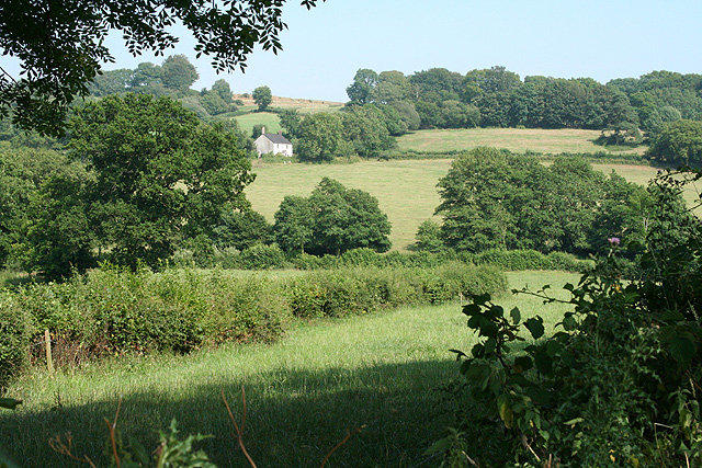
Churchinford is a small village located in the county of Devon, England. Situated in the picturesque Blackdown Hills, it is a rural community surrounded by rolling countryside and stunning natural beauty. The village lies approximately 10 miles northeast of the town of Honiton and 16 miles southeast of the city of Taunton.

With a population of around 400 inhabitants, Churchinford is known for its close-knit community and friendly atmosphere. The heart of the village is dominated by the beautiful St. Mary's Church, which dates back to the 15th century and is a popular landmark for both locals and visitors. The churchyard provides a tranquil setting for reflection and offers breathtaking views of the surrounding countryside.

The village also boasts a primary school, village hall, and a local pub, the York Inn, which serves as a gathering place for residents. The village hall hosts various community events throughout the year, including fundraisers, dances, and social gatherings.

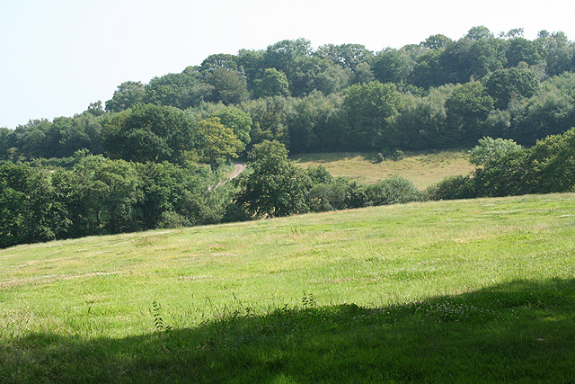
Churchinford is surrounded by lush green fields and woodlands, making it an ideal location for outdoor enthusiasts. There are several scenic walking and cycling trails in the area, allowing visitors to explore the natural beauty of the Blackdown Hills. The village is also within easy reach of the Blackdown Hills Area of Outstanding Natural Beauty, offering further opportunities for outdoor activities and exploration.

Overall, Churchinford is a charming village that offers a peaceful and idyllic lifestyle, making it an attractive place to live or visit for those seeking a rural retreat in the heart of Devon.

If you have any feedback on the listing, please let us know in the comments section below.
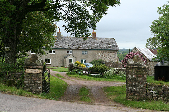
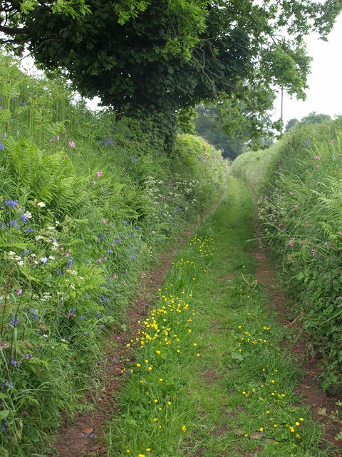
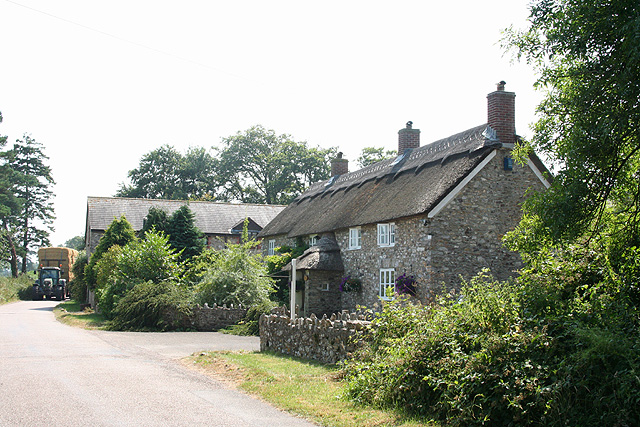
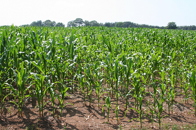
Churchinford Images

Images are sourced within 2km of 50.907907/-3.117336 or Grid Reference ST2112. Thanks to Geograph Open Source API. All images are credited.

Churchstanton : Country Lane Looking along the road by Kedget Barton.
Churchstanton : Country Lane
Looking along the road by Kedget Barton.
Churchstanton : Country Lane Looking along a small lane.
Churchstanton : Country Lane
Looking along a small lane.
Churchstanton : Grassy Field & Horses Horses in a field.
Churchstanton : Grassy Field & Horses
Horses in a field.
Churchstanton : Country Lane Looking along a small lane alongside Dreamcote.
Churchstanton : Country Lane
Looking along a small lane alongside Dreamcote.
Churchstanton : Country Lane A lane passing Homemead.
Churchstanton : Country Lane
A lane passing Homemead.
Churchstanton : Grassy Field & Pigs Pigs in a field.
Churchstanton : Grassy Field & Pigs
Pigs in a field.
Churchstanton : Track A track alongside a field.
Churchstanton : Track
A track alongside a field.
Churchstanton : Grassy Field & Pigs Looking towards pigs in a field.
Churchstanton : Grassy Field & Pigs
Looking towards pigs in a field.
Churchstanton : Grassy Field Looking beyond a gate and into the field.
Churchstanton : Grassy Field
Looking beyond a gate and into the field.
Churchstanton: Kedget Barton In the fork between roads to Hemyock and to Willand, Churchstanton, Looking north west
Churchstanton: Kedget Barton
In the fork between roads to Hemyock and to Willand, Churchstanton, Looking north west
Footpath near Willand Footpath T 6/17 follows a very green lane (it's raining, so it's hardly surprising it's green) past flower-bedecked banks and an oak tree.
Footpath near Willand
Footpath T 6/17 follows a very green lane (it's raining, so it's hardly surprising it's green) past flower-bedecked banks and an oak tree.
Churchstanton: Taunton – Honiton road Looking south-south-west in the Honiton direction on a cold overcast May day
Churchstanton: Taunton – Honiton road
Looking south-south-west in the Honiton direction on a cold overcast May day
Churchstanton: a Blackdown crossroads The road ahead leads to Churchstanton, now barely a hamlet with church, rectory and a defunct public house. Looking north west
Churchstanton: a Blackdown crossroads
The road ahead leads to Churchstanton, now barely a hamlet with church, rectory and a defunct public house. Looking north west
Upottery: Lambpark Farmhouse A datestone by the porch, partially obscured by thatch, indicates that this building was erected in 1795 or 1796. All the buildings here are now residential: the farming function has ceased
Upottery: Lambpark Farmhouse
A datestone by the porch, partially obscured by thatch, indicates that this building was erected in 1795 or 1796. All the buildings here are now residential: the farming function has ceased
Upottery: new crop Looking south west across a field near Lambpark
Upottery: new crop
Looking south west across a field near Lambpark
Upottery: Knackers Hole Lane This lane defines the border between Devon and Somerset and the parishes of Upottery and Churchstanton. Looking east-north-east
Upottery: Knackers Hole Lane
This lane defines the border between Devon and Somerset and the parishes of Upottery and Churchstanton. Looking east-north-east
Upottery: towards Lower Luxton Looking south-south-east across a valley to the east of Higher Luxton
Upottery: towards Lower Luxton
Looking south-south-east across a valley to the east of Higher Luxton
Upottery: towards Williambeer Farm Looking east across the Otter valley
Upottery: towards Williambeer Farm
Looking east across the Otter valley
Show me another place!

Churchinford is located at Grid Ref: ST2112 (Lat: 50.907907, Lng: -3.117336)

Administrative County: Somerset

District: Somerset West and Taunton

Police Authority: Avon and Somerset

What 3 Words

///reds.dubbing.sprayer. Near Hemyock, Devon

Nearby Locations

Churchinford

Related Wikis

Otterhead Lakes

Otterhead Lakes are a pair of reservoirs in the Blackdown Hills Area of Outstanding Natural Beauty south of Otterford in Somerset, England. They are fed...

Church of St Leonard, Otterford

The Anglican Church of St Leonard in Otterford, Somerset, England was built in the 14th century. It is a Grade II* listed building. == History == The church...

Otterford

Otterford is a village and civil parish in Somerset, England. It is situated on the Blackdown Hills, 7 miles (11.3 km) south of Taunton. The village has...

Robin Hood's Butts

Robin Hood's Butts are a group of nine Bronze Age barrows near Otterford on the Blackdown Hills in Somerset, England. They have been scheduled as ancient...

Nearby Amenities

Located within 500m of 50.907907,-3.117336
Post Office
Churchinford Post Office
Addr City: Taunton
Addr Country: GB
Addr County: Somerset
Addr Housenumber: 1
Addr Parentstreet: Taunton Road
Addr Postcode: TA3 7DJ
Addr Street: Barn Close
Addr Village: Churchinford
Brand: Post Office
Brand Wikidata: Q1783168
Opening Hours: Mo-Fr 09:00-17:00
Operator: Post Office Ltd
Ref Pol Id: 132277
Lat/Long: 50.908367/-3.1204399
Churchinford
Is In County: Somerset
Place: village
Source: OS_OpenData_StreetView
Lat/Long: 50.9077246/-3.1205615
Bench
Lat/Long: 50.9078724/-3.1206835
Post Box
Collection Times: Mo-Fr 16:15; Sa 11:00
Drive Through: no
Operator: Royal Mail
Operator Wikidata: Q638098
Post Box Type: wall
Ref: TA3 397
Royal Cypher: GR
Royal Cypher Wikidata: Q33102273
Lat/Long: 50.907552/-3.1208055
Give Way
Direction: backward
Lat/Long: 50.9076017/-3.1204569
Stop
Direction: forward
Stop: all
Lat/Long: 50.9076017/-3.1207398
Give Way
Direction: forward
Lat/Long: 50.9076262/-3.120616
Give Way
Direction: forward
Lat/Long: 50.9077906/-3.1206677
Cafe
Addr City: Taunton
Addr Country: GB
Addr County: Somerset
Addr Housenumber: 1
Addr Parentstreet: Taunton Road
Addr Postcode: TA3 7DJ
Addr Street: Barn Close
Addr Village: Churchinford
Opening Hours: Mo-Fr 08:00-16:30; Sa 08:00-13:00
Lat/Long: 50.9083109/-3.1204622
Direction: 35
Information: board
Tourism: information
Lat/Long: 50.9074159/-3.1206574
Entrance: main
Lat/Long: 50.9077722/-3.119527
Power: pole
Source: bing
Transformer: distribution
Lat/Long: 50.9076528/-3.1187658
Power: pole
Source: bing
Lat/Long: 50.9081333/-3.1173304
Power: pole
Source: bing
Lat/Long: 50.9066601/-3.1141707
Power: pole
Source: bing
Lat/Long: 50.9072715/-3.1131247
Power: pole
Source: bing
Lat/Long: 50.9072766/-3.1111318
Power: pole
Source: bing
Lat/Long: 50.9077908/-3.1120786
Power: pole
Source: bing
Lat/Long: 50.9083895/-3.1131676
Power: pole
Source: bing
Lat/Long: 50.9086499/-3.1157868
Power: pole
Source: bing
Lat/Long: 50.9090964/-3.1144644
Power: pole
Source: bing
Lat/Long: 50.9097053/-3.1127733
Power: pole
Source: bing
Lat/Long: 50.9106608/-3.1124541
Power: pole
Source: bing
Lat/Long: 50.9109145/-3.1134197
Power: pole
Source: bing
Lat/Long: 50.9114591/-3.1141841
Power: pole
Source: bing
Lat/Long: 50.9120256/-3.1149539
Power: pole
Source: bing
Lat/Long: 50.9122472/-3.1166813
Defibrillator
Access: yes
Booth: K6
Covered: booth
Defibrillator Location: inside old red phone box outside Churchinford Village Hall
Disused Amenity: telephone
Emergency: defibrillator
Man Made: telephone_box
Lat/Long: 50.9082015/-3.1203202
Post Box
Post Box Design: type_n
Post Box Type: lamp
Royal Cypher: EIIR
Lat/Long: 50.9082429/-3.1204269
The data included in this document is from www.openstreetmap.org. The data is made available under ODbL.

Have you been to Churchinford?

Leave your review of Churchinford below (or comments, questions and feedback).