Meadwell Copse

Wood, Forest in Devon South Hams

England

Meadwell Copse

Old Boundary Marker on Blachford Road in Ivybridge Parish Boundary Marker set against the west end of the south parapet of the bridge over the River Erme, on the southeast side of the junction of Erme Road and Blachford Road. Ivybridge parish. Inscribed Ermington. Until 1894 when Ivybridge parish was created the River Erme was the boundary of Ermington and Ugborough south of the bridge, and Cornwood and Harford north of it.

Grade II Listed details <span class="nowrap"><a title="https://historicengland.org.uk/listing/the-list/list-entry/1107424" rel="nofollow ugc noopener" href="https://historicengland.org.uk/listing/the-list/list-entry/1107424">Link</a><img style="margin-left:2px;" alt="External link" title="External link - shift click to open in new window" src="https://s1.geograph.org.uk/img/external.png" width="10" height="10"/></span>.

Milestone Society National ID: DV_PLEX10apb
Old Boundary Marker on Blachford Road in Ivybridge Credit: T Jenkinson

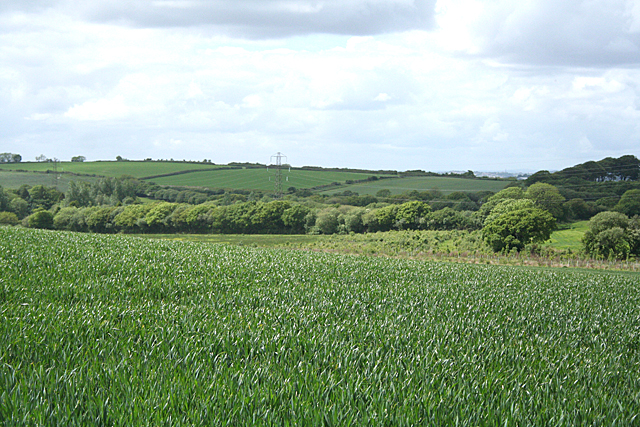
Meadwell Copse is a picturesque woodland located in Devon, England. Covering an area of approximately 50 acres, it is a haven for nature enthusiasts and those seeking solace in the tranquility of the countryside. Situated near the village of Meadwell, the copse is surrounded by rolling hills and offers breathtaking views of the surrounding landscape.

The woodland is predominantly composed of deciduous trees, including oak, beech, and ash, which provide a dense canopy and create a cool, shaded environment. The forest floor is covered in a thick carpet of moss, ferns, and wildflowers, adding to the magical ambiance of the copse.

Meadwell Copse is home to a diverse range of wildlife, making it a popular spot for birdwatching and nature photography. Visitors can spot a variety of species, such as woodpeckers, owls, and songbirds, flitting among the branches. Squirrels can often be seen darting through the trees, gathering nuts and acorns, while deer and foxes occasionally make appearances, adding to the sense of wilderness.

Several walking trails wind through the copse, allowing visitors to explore and immerse themselves in the beauty of nature. These paths meander through the dense woodland, occasionally opening up to reveal picturesque clearings and babbling brooks, providing opportunities for picnicking or simply enjoying the serene atmosphere.

Meadwell Copse is a true gem of Devon, offering a peaceful retreat from the hustle and bustle of everyday life. Its natural beauty and abundant wildlife make it a must-visit destination for anyone seeking a connection with nature.

If you have any feedback on the listing, please let us know in the comments section below.

Meadwell Copse Images

Images are sourced within 2km of 50.377695/-3.937007 or Grid Reference SX6254. Thanks to Geograph Open Source API. All images are credited.

Old Boundary Marker on Blachford Road in Ivybridge Parish Boundary Marker set against the west end of the south parapet of the bridge over the River Erme, on the southeast side of the junction of Erme Road and Blachford Road. Ivybridge parish. Inscribed Ermington. Until 1894 when Ivybridge parish was created the River Erme was the boundary of Ermington and Ugborough south of the bridge, and Cornwood and Harford north of it.

Grade II Listed details <span class="nowrap"><a title="https://historicengland.org.uk/listing/the-list/list-entry/1107424" rel="nofollow ugc noopener" href="https://historicengland.org.uk/listing/the-list/list-entry/1107424">Link</a><img style="margin-left:2px;" alt="External link" title="External link - shift click to open in new window" src="https://s1.geograph.org.uk/img/external.png" width="10" height="10"/></span>.

Milestone Society National ID: DV_PLEX10apb
Old Boundary Marker on Blachford Road in Ivybridge
Parish Boundary Marker set against the west end of the south parapet of the bridge over the River Erme, on the southeast side of the junction of Erme Road and Blachford Road. Ivybridge parish. Inscribed Ermington. Until 1894 when Ivybridge parish was created the River Erme was the boundary of Ermington and Ugborough south of the bridge, and Cornwood and Harford north of it. Grade II Listed details LinkExternal link. Milestone Society National ID: DV_PLEX10apb
Old Boundary Marker on Blachford Road in Ivybridge Parish Boundary Marker set against the east end of the south parapet of the bridge over the River Erme, on the southwest side of the junction of Harford Road and Blachford Road. Ivybridge parish. Inscribed Ermington. Until 1894 when Ivybridge parish was created the River Erme was the boundary of Ermington and Ugborough south of the bridge, and Cornwood and Harford north of it.

Grade II Listed details <span class="nowrap"><a title="https://historicengland.org.uk/listing/the-list/list-entry/1107424" rel="nofollow ugc noopener" href="https://historicengland.org.uk/listing/the-list/list-entry/1107424">Link</a><img style="margin-left:2px;" alt="External link" title="External link - shift click to open in new window" src="https://s1.geograph.org.uk/img/external.png" width="10" height="10"/></span>.

Milestone Society National ID: DV_PLEX10bpb
Old Boundary Marker on Blachford Road in Ivybridge
Parish Boundary Marker set against the east end of the south parapet of the bridge over the River Erme, on the southwest side of the junction of Harford Road and Blachford Road. Ivybridge parish. Inscribed Ermington. Until 1894 when Ivybridge parish was created the River Erme was the boundary of Ermington and Ugborough south of the bridge, and Cornwood and Harford north of it. Grade II Listed details LinkExternal link. Milestone Society National ID: DV_PLEX10bpb
Old Boundary Marker on Cleeve Drive, Ivybridge Parish Boundary Marker set on the footpath above the old road Kennel Lane against metal fencing on the south side of Cleeve Drive 30 metres west of the top end of Blatchford Road. Ivybridge parish. Inscribed ILB for Ivybridge Local Board.

Milestone Society National ID: DV_IBSpb
Old Boundary Marker on Cleeve Drive, Ivybridge
Parish Boundary Marker set on the footpath above the old road Kennel Lane against metal fencing on the south side of Cleeve Drive 30 metres west of the top end of Blatchford Road. Ivybridge parish. Inscribed ILB for Ivybridge Local Board. Milestone Society National ID: DV_IBSpb
Devon Expressway, Westover Junction The A38 is a major A-class trunk route. When first designated in 1922, it ran from Derby to Plymouth but it was later extended at both ends so that it now runs for 292 miles from Mansfield in Nottinghamshire to Bodmin in Cornwall.

Prior to the opening of the M5 motorway in the 1960s and 1970s, the A38 formed the main "holiday route" from the Midlands to Somerset, Devon and Cornwall and the south-western section was notorious at holiday times for the congestion. Nowadays, for most of the southern section, the A38 is a fairly quiet road shadowing the M5 extremely closely; often running alongside the motorway as a single carriageway road. The section between Exeter and Plymouth is, however, a busy dual carriageway which serves as the southern extension of the M5 and is known as “the Devon Expressway”.

More information at <span class="nowrap"><a title="http://en.wikipedia.org/wiki/A38_road" rel="nofollow ugc noopener" href="http://en.wikipedia.org/wiki/A38_road">Link</a><img style="margin-left:2px;" alt="External link" title="External link - shift click to open in new window" src="https://s1.geograph.org.uk/img/external.png" width="10" height="10"/></span>  (Wikipedia) and <span class="nowrap"><a title="http://www.sabre-roads.org.uk/wiki/index.php?title=A38" rel="nofollow ugc noopener" href="http://www.sabre-roads.org.uk/wiki/index.php?title=A38">Link</a><img style="margin-left:2px;" alt="External link" title="External link - shift click to open in new window" src="https://s1.geograph.org.uk/img/external.png" width="10" height="10"/></span>  (SABRE).
Devon Expressway, Westover Junction
The A38 is a major A-class trunk route. When first designated in 1922, it ran from Derby to Plymouth but it was later extended at both ends so that it now runs for 292 miles from Mansfield in Nottinghamshire to Bodmin in Cornwall. Prior to the opening of the M5 motorway in the 1960s and 1970s, the A38 formed the main "holiday route" from the Midlands to Somerset, Devon and Cornwall and the south-western section was notorious at holiday times for the congestion. Nowadays, for most of the southern section, the A38 is a fairly quiet road shadowing the M5 extremely closely; often running alongside the motorway as a single carriageway road. The section between Exeter and Plymouth is, however, a busy dual carriageway which serves as the southern extension of the M5 and is known as “the Devon Expressway”. More information at LinkExternal link (Wikipedia) and LinkExternal link (SABRE).
A38 at the Westlake Turnoff The A38 is a major A-class trunk route. When first designated in 1922, it ran from Derby to Plymouth but it was later extended at both ends so that it now runs for 292 miles from Mansfield in Nottinghamshire to Bodmin in Cornwall.

Prior to the opening of the M5 motorway in the 1960s and 1970s, the A38 formed the main "holiday route" from the Midlands to Somerset, Devon and Cornwall and the south-western section was notorious at holiday times for the congestion. Nowadays, for most of the southern section, the A38 is a fairly quiet road shadowing the M5 extremely closely; often running alongside the motorway as a single carriageway road. The section between Exeter and Plymouth is, however, a busy dual carriageway which serves as the southern extension of the M5 and is known as “the Devon Expressway”.

More information at <span class="nowrap"><a title="http://en.wikipedia.org/wiki/A38_road" rel="nofollow ugc noopener" href="http://en.wikipedia.org/wiki/A38_road">Link</a><img style="margin-left:2px;" alt="External link" title="External link - shift click to open in new window" src="https://s1.geograph.org.uk/img/external.png" width="10" height="10"/></span>  (Wikipedia) and <span class="nowrap"><a title="http://www.sabre-roads.org.uk/wiki/index.php?title=A38" rel="nofollow ugc noopener" href="http://www.sabre-roads.org.uk/wiki/index.php?title=A38">Link</a><img style="margin-left:2px;" alt="External link" title="External link - shift click to open in new window" src="https://s1.geograph.org.uk/img/external.png" width="10" height="10"/></span>  (SABRE).
A38 at the Westlake Turnoff
The A38 is a major A-class trunk route. When first designated in 1922, it ran from Derby to Plymouth but it was later extended at both ends so that it now runs for 292 miles from Mansfield in Nottinghamshire to Bodmin in Cornwall. Prior to the opening of the M5 motorway in the 1960s and 1970s, the A38 formed the main "holiday route" from the Midlands to Somerset, Devon and Cornwall and the south-western section was notorious at holiday times for the congestion. Nowadays, for most of the southern section, the A38 is a fairly quiet road shadowing the M5 extremely closely; often running alongside the motorway as a single carriageway road. The section between Exeter and Plymouth is, however, a busy dual carriageway which serves as the southern extension of the M5 and is known as “the Devon Expressway”. More information at LinkExternal link (Wikipedia) and LinkExternal link (SABRE).
Eastbound A38, Exit for Ivybridge The A38 is a major A-class trunk route. When first designated in 1922, it ran from Derby to Plymouth but it was later extended at both ends so that it now runs for 292 miles from Mansfield in Nottinghamshire to Bodmin in Cornwall.

Prior to the opening of the M5 motorway in the 1960s and 1970s, the A38 formed the main "holiday route" from the Midlands to Somerset, Devon and Cornwall and the south-western section was notorious at holiday times for the congestion. Nowadays, for most of the southern section, the A38 is a fairly quiet road shadowing the M5 extremely closely; often running alongside the motorway as a single carriageway road. The section between Exeter and Plymouth is, however, a busy dual carriageway which serves as the southern extension of the M5 and is known as “the Devon Expressway”.

More information at <span class="nowrap"><a title="http://en.wikipedia.org/wiki/A38_road" rel="nofollow ugc noopener" href="http://en.wikipedia.org/wiki/A38_road">Link</a><img style="margin-left:2px;" alt="External link" title="External link - shift click to open in new window" src="https://s1.geograph.org.uk/img/external.png" width="10" height="10"/></span>  (Wikipedia) and <span class="nowrap"><a title="http://www.sabre-roads.org.uk/wiki/index.php?title=A38" rel="nofollow ugc noopener" href="http://www.sabre-roads.org.uk/wiki/index.php?title=A38">Link</a><img style="margin-left:2px;" alt="External link" title="External link - shift click to open in new window" src="https://s1.geograph.org.uk/img/external.png" width="10" height="10"/></span>  (SABRE).
Eastbound A38, Exit for Ivybridge
The A38 is a major A-class trunk route. When first designated in 1922, it ran from Derby to Plymouth but it was later extended at both ends so that it now runs for 292 miles from Mansfield in Nottinghamshire to Bodmin in Cornwall. Prior to the opening of the M5 motorway in the 1960s and 1970s, the A38 formed the main "holiday route" from the Midlands to Somerset, Devon and Cornwall and the south-western section was notorious at holiday times for the congestion. Nowadays, for most of the southern section, the A38 is a fairly quiet road shadowing the M5 extremely closely; often running alongside the motorway as a single carriageway road. The section between Exeter and Plymouth is, however, a busy dual carriageway which serves as the southern extension of the M5 and is known as “the Devon Expressway”. More information at LinkExternal link (Wikipedia) and LinkExternal link (SABRE).
Snowy Cornwood Road Making for rather slippery driving and walking conditions.
Snowy Cornwood Road
Making for rather slippery driving and walking conditions.
Western Road, Ivybridge Snowy scene . Looking East towards the town centre
Western Road, Ivybridge
Snowy scene . Looking East towards the town centre
Snowy Fore Street, Ivybridge Looking Northeast, up the road.
Snowy Fore Street, Ivybridge
Looking Northeast, up the road.
Ermington: lane to Worthele Cross And on to Ivybridge. In Ermington parish
Ermington: lane to Worthele Cross
And on to Ivybridge. In Ermington parish
Ermington: towards Tod Moor Not far from Westlake in Ermington parish
Ermington: towards Tod Moor
Not far from Westlake in Ermington parish
Ermington: Ivybridge NTL tower TV transmitter on a high point between Ivybridge and the village of Ermington
Ermington: Ivybridge NTL tower
TV transmitter on a high point between Ivybridge and the village of Ermington
Ermington: Worthele Cross The lane by the signpost leads to East Worthele farm
Ermington: Worthele Cross
The lane by the signpost leads to East Worthele farm
Ermington: towards Ivybridge View from Worthele Cross with Western Beacon on the skyline, centre right. Overlooking a field of mown grass
Ermington: towards Ivybridge
View from Worthele Cross with Western Beacon on the skyline, centre right. Overlooking a field of mown grass
Memorial to American Servicemen, Ivybridge The inscription on the granite block reads: "Dedicated to all the American Servicemen based in Ivybridge 1943-1944 particularly the 1st Battalion 116th Infantry Regiment who made many friends with local residents. Sadly many of these men were to die on, or after, D-Day the 6th June 1944". 

Behind is [[880607].
Memorial to American Servicemen, Ivybridge
The inscription on the granite block reads: "Dedicated to all the American Servicemen based in Ivybridge 1943-1944 particularly the 1st Battalion 116th Infantry Regiment who made many friends with local residents. Sadly many of these men were to die on, or after, D-Day the 6th June 1944". Behind is [[880607].
Ermington: towards Tod Moor Field ploughed, harrowed and sown. Compare with a similar view -<a href="https://www.geograph.org.uk/photo/2407302">SX6253 : Ermington: towards Tod Moor</a>
Ermington: towards Tod Moor
Field ploughed, harrowed and sown. Compare with a similar view -SX6253 : Ermington: towards Tod Moor
The Western end of Fore Street, Ivybridge
Newly built  house at Thornham
Newly built house at Thornham
Show me another place!

Meadwell Copse is located at Grid Ref: SX6254 (Lat: 50.377695, Lng: -3.937007)

Administrative County: Devon

District: South Hams

Police Authority: Devon and Cornwall

What 3 Words

///cocoons.started.tidal. Near Ivybridge, Devon

Related Wikis

Ivybridge Town F.C.

Ivybridge Town Football Club is an amateur football club based in Ivybridge, Devon, England. They are currently members of the South West Peninsula League...

Ivybridge Priory

Ivybridge Priory or St. Austin's Priory was a monastic house in Devon, England. From 1932 it was a priory of the Order of Augustinian Recollects. They...

Ivybridge

Ivybridge is a town and civil parish in the South Hams, in Devon, England. It lies about thirteen miles (twenty-one kilometres) east of Plymouth. It...

Ivybridge Community College

Ivybridge Community College is a state-funded secondary school and academy in Ivybridge, Devon, England. Located on the southern slopes of Dartmoor, it...

Nearby Amenities

Located within 500m of 50.377695,-3.937007
Marjery Cross
Place: locality
Lat/Long: 50.3769069/-3.9378455
Power: tower
Lat/Long: 50.3784796/-3.9335055
Power: tower
Lat/Long: 50.3774856/-3.9365057
Power: tower
Lat/Long: 50.3763844/-3.9401133
Power: pole
Lat/Long: 50.3810752/-3.9350192
Power: pole
Lat/Long: 50.3786775/-3.9362678
Power: pole
Lat/Long: 50.3760672/-3.9363053
Power: pole
Lat/Long: 50.3749468/-3.9380837
Power: pole
Lat/Long: 50.3738041/-3.9399344
Post Box
Brand: Royal Mail
Brand Wikidata: Q638098
Brand Wikipedia: en:Royal Mail
Collection Times: Mo-Sa 10:00; Su off
Operator: Royal Mail
Operator Wikidata: Q638098
Post Box Mounting: pier
Post Box Type: lamp
Ref: PL21 809
Royal Cypher: EIIR
Royal Cypher Wikidata: Q33102113
Source: survey;streetlevel imagery;aerial imagery
Lat/Long: 50.3769276/-3.9377913
Power: pole
Lat/Long: 50.3768079/-3.9362571
Power: pole
Lat/Long: 50.3776965/-3.9362544
Power: pole
Lat/Long: 50.3749023/-3.9372629
Power: pole
Lat/Long: 50.3747056/-3.9356348
Power: pole
Lat/Long: 50.3745311/-3.9340469
Power: tower
Lat/Long: 50.3766832/-3.9432946
The data included in this document is from www.openstreetmap.org. The data is made available under ODbL.

Have you been to Meadwell Copse?

Leave your review of Meadwell Copse below (or comments, questions and feedback).