Anderby Creek

Settlement in Lincolnshire East Lindsey

England

Anderby Creek

Marsh Yard Public Conveniences
Marsh Yard Public Conveniences Credit: Alex McGregor

Anderby Creek is a small coastal village located in the county of Lincolnshire, England. Situated on the East Coast, it lies approximately 6 miles north of the town of Skegness. The village is part of the larger civil parish of Anderby, which also includes the nearby settlements of Anderby and Chapel St. Leonards.

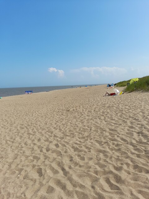
Known for its stunning sandy beach, Anderby Creek is a popular destination for locals and tourists alike, especially during the summer months. The beach stretches for miles and offers picturesque views of the North Sea. The area is also home to the Anderby Creek Nature Reserve, which provides a habitat for a variety of bird species and other wildlife.

Despite its small size, Anderby Creek offers a range of amenities for visitors. These include a café, a small shop, and a caravan park, making it a convenient spot for a day trip or a longer stay. The village also boasts a caravan club site, providing accommodation for those looking to enjoy the tranquility of the area.

Anderby Creek is easily accessible by road, with the A52 running nearby, connecting it to other towns and cities in the region. The village is also served by public transport, with regular bus services connecting it to Skegness and other nearby towns.

Overall, Anderby Creek offers a peaceful and picturesque coastal retreat, with its beautiful beach and natural surroundings attracting visitors throughout the year.

If you have any feedback on the listing, please let us know in the comments section below.

Anderby Creek Images

Images are sourced within 2km of 53.259537/0.32111 or Grid Reference TF5476. Thanks to Geograph Open Source API. All images are credited.

Marsh Yard Public Conveniences
Marsh Yard car park
Marsh Yard car park
Marsh Yard car park
Marsh Yard car park
Moggs Eye
Moggs Eye
Moggs Eye
Moggs Eye
Anderby Creek Beach The weather had taken a turn for the worse by the time this photograph was taken in late afternoon - the earlier sunshine had gone to be replaced by rain and a cold wind. The sign proclaims this to be a child-friendly beach (whatever that actually means) but unsurprisingly there were no children, or anybody else for that matter, to be seen.
Anderby Creek Beach
The weather had taken a turn for the worse by the time this photograph was taken in late afternoon - the earlier sunshine had gone to be replaced by rain and a cold wind. The sign proclaims this to be a child-friendly beach (whatever that actually means) but unsurprisingly there were no children, or anybody else for that matter, to be seen.
Dredging operation, Moggs Eye, Anderby Creek: aerial 2023 See: <a href="https://www.geograph.org.uk/photo/7546850">TF5871 : Dredging and beach replenishment, Chapel St Leonards: aerial 2023 (1)</a>
Dredging operation, Moggs Eye, Anderby Creek: aerial 2023
Fields west of Mogg's Eye (Anderby Creek): aerial 2023
Field entrance adjacent to The Grange, Anderby
Main drain. Anderby
Main drain. Anderby
Pinfold Lane. Anderby Becomes a footpath to Anderby Creek.
Pinfold Lane. Anderby
Becomes a footpath to Anderby Creek.
Anderby Pump The large black pipes are part of the Anderby Creek drainage pump.  The building in the background houses the old diesel powered pump which runs occasionally during the summer months.
Anderby Pump
The large black pipes are part of the Anderby Creek drainage pump. The building in the background houses the old diesel powered pump which runs occasionally during the summer months.
Path to the Sea This road is also a footpath which leads to the sea just over the bank on the horizon.
Path to the Sea
This road is also a footpath which leads to the sea just over the bank on the horizon.
Path to Anderby This track is a footpath to Anderby Creek.
Path to Anderby
This track is a footpath to Anderby Creek.
Path to Langham This footpath leads to Langham Farm in the next square south.
Path to Langham
This footpath leads to Langham Farm in the next square south.
Gap in the Hedge The sheep in this field use the gap in the hedge to find out if the grass is greener in the other field.  It isn't.
Gap in the Hedge
The sheep in this field use the gap in the hedge to find out if the grass is greener in the other field. It isn't.
First 30 These 30 signs are on the road into Anderby Creek from the east, that is the sea.
First 30
These 30 signs are on the road into Anderby Creek from the east, that is the sea.
Anderby Creek Beach This line of vent pipes marks where Anderby Creek joins the sea.
Anderby Creek Beach
This line of vent pipes marks where Anderby Creek joins the sea.
Show me another place!

Anderby Creek is located at Grid Ref: TF5476 (Lat: 53.259537, Lng: 0.32111)

Division: Parts of Lindsey

Administrative County: Lincolnshire

District: East Lindsey

Police Authority: Lincolnshire

What 3 Words

///zealous.constrain.safest. Near Chapel St Leonards, Lincolnshire

Related Wikis

Anderby Creek

Anderby Creek is a small holiday village in Lincolnshire, England, to the north of Skegness. Part of the parish of Anderby, it is on the North Sea coast...

Anderby

Anderby is a village and civil parish in the East Lindsey district of Lincolnshire, England. It has a population of 335, according to the 2001 Census....

Huttoft

Huttoft is a village in the East Lindsey district of Lincolnshire, England, about 4 miles (6 km) east of the market town of Alford, on the A52 road between...

Mumby

Mumby is a village in the East Lindsey district of Lincolnshire, England. It is located 4 miles (6 km) south-east from the town of Alford. In 2001 the...

Hogsthorpe

Hogsthorpe is a small village in the East Lindsey district of Lincolnshire, England. It is situated approximately 2 miles (3 km) from the North Sea and...

Chapel St Leonards

Chapel St. Leonards is a seaside resort village and civil parish in the East Lindsey district of Lincolnshire, England. It is situated 5 miles (8 km) north...

Helsey

Helsey is a hamlet in the civil parish of Mumby, and the East Lindsey district of Lincolnshire, England. It lies on the A52 1 mile (1.6 km) north-east...

Cumberworth

Cumberworth is a small village and civil parish in the East Lindsey district of Lincolnshire, England. It is situated approximately 3 miles (5 km) south...

Nearby Amenities

Located within 500m of 53.259537,0.32111
Sea Road
Naptan AtcoCode: 270000009831
Naptan Bearing: SE
Naptan BusStopType: CUS
Naptan CommonName: Sea Road
Naptan Indicator: adj
Naptan Landmark: Sea Road
Naptan NaptanCode: linjgajt
Naptan Street: Roman Bank
Naptan Verified: no
Source: naptan_import
Lat/Long: 53.2593953/0.3159588
Bus Stop
Sea Road
Naptan AtcoCode: 2700LACB4036
Naptan Bearing: NW
Naptan CommonName: Sea Road
Naptan Indicator: opp
Naptan Landmark: Sea Road
Naptan NaptanCode: lindgwjd
Naptan Street: Roman Bank
Naptan Verified: no
Source: naptan_import
Lat/Long: 53.2595281/0.3156061
Anderby Creek
Place: hamlet
Source: Bing
Wikidata: Q4753699
Wikipedia: en:Anderby Creek
Lat/Long: 53.2608679/0.3203241
Bank House
Place: isolated_dwelling
Source: Bing
Lat/Long: 53.2572822/0.3166076
Fixme: How does this path connect to the car park?
Lat/Long: 53.2601273/0.3240339
Bicycle Parking
Bicycle Parking: stands
Capacity: 10
Covered: no
Lat/Long: 53.2597451/0.3240469
Bench
Lat/Long: 53.2596215/0.3246189
Roundhouse
Artwork Type: installation
Tourism: artwork
Lat/Long: 53.2567742/0.3261774
Leisure: picnic_table
Lat/Long: 53.2593979/0.3238204
Leisure: picnic_table
Lat/Long: 53.2598295/0.3240202
Leisure: picnic_table
Lat/Long: 53.2598624/0.3240135
Defibrillator
Defibrillator Location: On exterior wall of Popas, facing Sea Road.
Emergency: defibrillator
Lat/Long: 53.2595556/0.3202573
Entrance: yes
Male: yes
Lat/Long: 53.2600704/0.3238984
Post Box
Collection Times: Mo-Fr 16:15; Sa 09:00
Post Box Mounting: brick_pillar
Post Box Type: wall
Ref: PE24 45
Royal Cypher: GR
Royal Cypher Wikidata: Q33102273
Lat/Long: 53.2594368/0.3239884
Defibrillator
Defibrillator Location: On exterior wall of Anderby Beach Cafe, facing the car park.
Emergency: defibrillator
Lat/Long: 53.2594036/0.3238914
The data included in this document is from www.openstreetmap.org. The data is made available under ODbL.

Have you been to Anderby Creek?

Leave your review of Anderby Creek below (or comments, questions and feedback).