Ancton

Settlement in Sussex Arun

England

Ancton

Coastal Path Coastal path passing the Middleton on Sea Association beach huts on the Greensward  <span class="nowrap"><a title="https://www.mosassociation.org/beach-huts" rel="nofollow ugc noopener" href="https://www.mosassociation.org/beach-huts">Link</a><img style="margin-left:2px;" alt="External link" title="External link - shift click to open in new window" src="https://s1.geograph.org.uk/img/external.png" width="10" height="10"/></span>
Coastal Path Credit: Shaun Ferguson

Ancton is a small village located in the district of Sussex, England. Situated approximately 5 miles north of Bognor Regis, it falls within the Arun local government district. The village is nestled amidst the beautiful countryside, offering its residents a serene and picturesque environment.

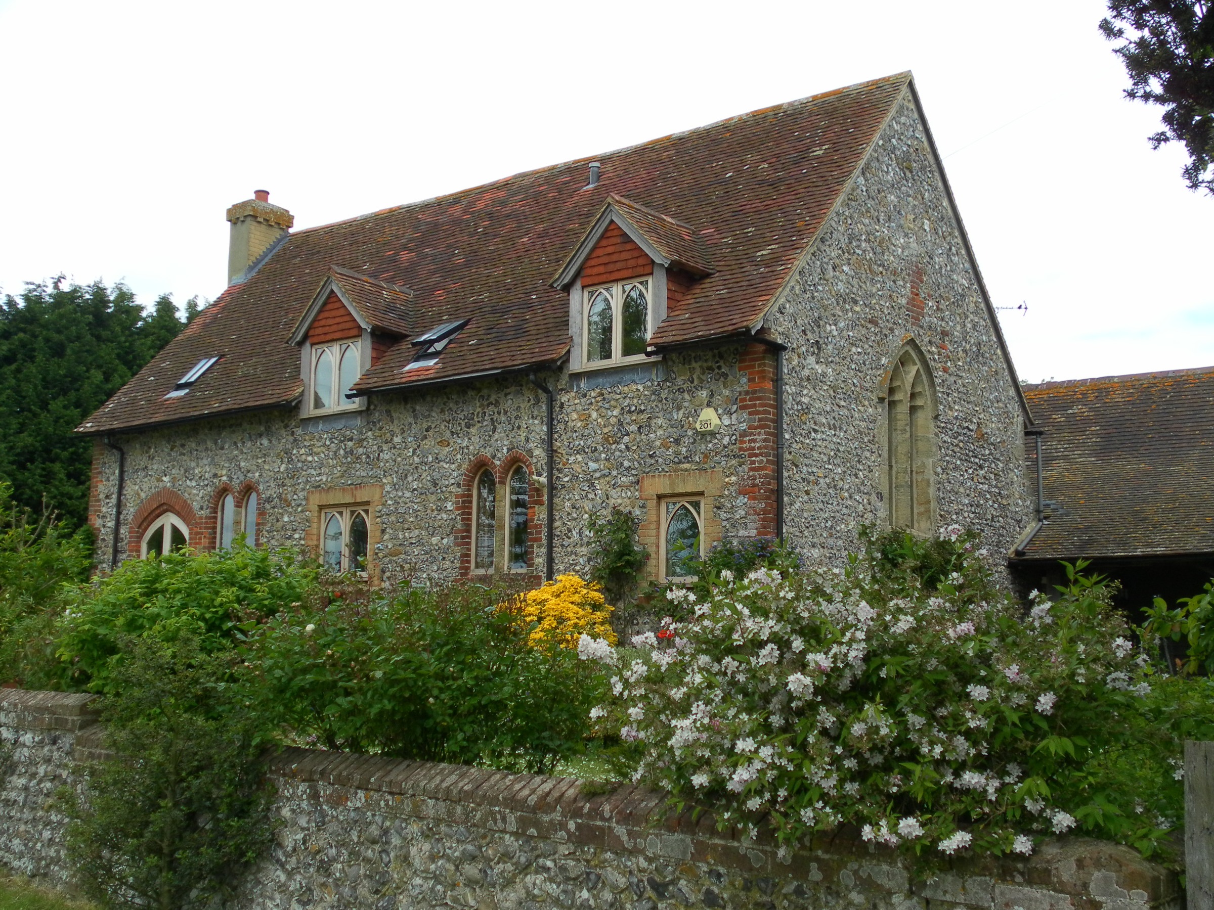
Ancton is known for its historical significance, with evidence of human settlement in the area dating back to the Roman times. The village is home to several ancient landmarks, including the Grade II listed Ancton Farmhouse, which dates back to the 16th century and stands as a testament to the area's architectural heritage.

Although small, Ancton has a tight-knit community that actively participates in various local events and initiatives. The village is proud of its community center, where residents gather for social activities and meetings. Additionally, Ancton hosts an annual summer fair, attracting visitors from nearby towns and fostering a sense of unity among the locals.

In terms of amenities, Ancton offers limited but essential facilities. There is a village shop that caters to the daily needs of the residents, while the nearest primary school is located in the neighboring village of North Bersted. For further educational opportunities, students have access to excellent secondary schools in Bognor Regis and the surrounding areas.

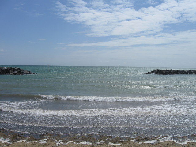
Ancton's charm lies in its tranquil setting, providing an escape from the hustle and bustle of city life. Its proximity to the coast and nearby nature reserves offers residents and visitors the opportunity to explore the stunning landscapes and enjoy outdoor activities.

If you have any feedback on the listing, please let us know in the comments section below.

Ancton Images

Images are sourced within 2km of 50.797406/-0.608817 or Grid Reference SU9800. Thanks to Geograph Open Source API. All images are credited.

Coastal Path Coastal path passing the Middleton on Sea Association beach huts on the Greensward  <span class="nowrap"><a title="https://www.mosassociation.org/beach-huts" rel="nofollow ugc noopener" href="https://www.mosassociation.org/beach-huts">Link</a><img style="margin-left:2px;" alt="External link" title="External link - shift click to open in new window" src="https://s1.geograph.org.uk/img/external.png" width="10" height="10"/></span>
Coastal Path
Coastal path passing the Middleton on Sea Association beach huts on the Greensward LinkExternal link
Felpham Beach looking towards Middleton
Felpham Beach towards Bognor With Butlins in the far distance.
Felpham Beach towards Bognor
With Butlins in the far distance.
Elmer Beach, Elmer
Elmer Beach, Elmer
Elmer Beach, Elmer
Elmer Beach, Elmer
Elmer Beach Breakwaters
Along the coast from Atherington to Elmer (39)
Flats, Frya Close Atypical for the sea front here, where private houses of normal proportions dominate.
Flats, Frya Close
Atypical for the sea front here, where private houses of normal proportions dominate.
Sea front, Elmer On the right off shore are man-made bars of rock intended to prevent further coastal erosion here. They have produced a remarkable beach line, with small bays opposite the gaps in the bar, and headlands opposite the centre of each bar.
Sea front, Elmer
On the right off shore are man-made bars of rock intended to prevent further coastal erosion here. They have produced a remarkable beach line, with small bays opposite the gaps in the bar, and headlands opposite the centre of each bar.
Two seats and a walk-way to the beach There is a path but not marked as a public footpath.
Two seats and a walk-way to the beach
There is a path but not marked as a public footpath.
Art deco house on the coastal path to Middleton-on-Sea This is one of several along this stretch of the shoreline.
Art deco house on the coastal path to Middleton-on-Sea
This is one of several along this stretch of the shoreline.
Middleton-on-Sea Association's "Coastal Greensward" Along the edge of this are plants growing in the shingle, including the red flowers just visible. This is described on a notice board as "vegetated shingle".
Incidentally the red flowers are Valerian, a garden escapee which has taken a liking to this habitat.
Middleton-on-Sea Association's "Coastal Greensward"
Along the edge of this are plants growing in the shingle, including the red flowers just visible. This is described on a notice board as "vegetated shingle". Incidentally the red flowers are Valerian, a garden escapee which has taken a liking to this habitat.
Vegetated Shingle Along the edge of the Middleton-on-Sea Association's "Coastal Greensward" are plants growing in the shingle. This is described on a notice board as "vegetated shingle".
This is a very rare habitat, though seen in all its splendour a couple of miles to the west at Aldwick.
Incidentally the red flowers are Valerian, a garden escapee which has taken a liking to this habitat.
Vegetated Shingle
Along the edge of the Middleton-on-Sea Association's "Coastal Greensward" are plants growing in the shingle. This is described on a notice board as "vegetated shingle". This is a very rare habitat, though seen in all its splendour a couple of miles to the west at Aldwick. Incidentally the red flowers are Valerian, a garden escapee which has taken a liking to this habitat.
Vegetated Shingle (and a dog) Along the edge of the Middleton-on-Sea Association's "Coastal Greensward" are plants growing in the shingle. This is described on a notice board as "vegetated shingle".
This is a very rare habitat, though seen in all its splendour a couple of miles to the west at Aldwick.
These red flowers are Valerian, a garden escapee which has taken a liking to this habitat.
Vegetated Shingle (and a dog)
Along the edge of the Middleton-on-Sea Association's "Coastal Greensward" are plants growing in the shingle. This is described on a notice board as "vegetated shingle". This is a very rare habitat, though seen in all its splendour a couple of miles to the west at Aldwick. These red flowers are Valerian, a garden escapee which has taken a liking to this habitat.
Footpath 3052 at Middleton-on-Sea The path starts here and follows the shoreline to Bognor Regis. The path does not continue east due to sea defences and private gardens see <a href="https://www.geograph.org.uk/photo/3624866">SZ9799 : Sea defences and private gardens along Middleton beach</a>
Footpath 3052 at Middleton-on-Sea
The path starts here and follows the shoreline to Bognor Regis. The path does not continue east due to sea defences and private gardens see SZ9799 : Sea defences and private gardens along Middleton beach
Sea defences and private gardens along Middleton beach
Leverton Avenue Felpham
Path from beach to Southdean Drive Public footpath 162.
Path from beach to Southdean Drive
Public footpath 162.
Show me another place!

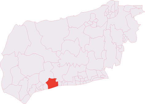
Ancton is located at Grid Ref: SU9800 (Lat: 50.797406, Lng: -0.608817)

Administrative County: West Sussex

District: Arun

Police Authority: Sussex

What 3 Words

///dividers.hops.chap. Near Yapton, West Sussex

Nearby Locations

Ancton Elmer

Related Wikis

Elmer, West Sussex

Elmer is a coastal village in the Arun district of West Sussex, England. It is part of the built-up area around Bognor Regis. Its postal address is "Elmer...

Bognor Regis and Littlehampton (UK Parliament constituency)

Bognor Regis and Littlehampton (contemp. RP [/ˈbɒɡnə ɹʷiːd͡ʒɪs ænd lɪtl̩hæmptn̩/, /-æmtn̩/]) is a constituency in West Sussex represented in the House...

Middleton-on-Sea

Middleton-on-Sea is a village, civil parish and an electoral ward in the Arun District of West Sussex, England, lying to the east of Bognor Regis and...

Bilsham Chapel

Bilsham Chapel is a deconsecrated former chapel in the hamlet of Bilsham in West Sussex, England. Founded in the 13th century as a chapel of ease to the...

Middleton (electoral division)

Middleton is an electoral division of West Sussex in the United Kingdom and returns one member to sit on West Sussex County Council. == Extent == The division...

Bailiffscourt Chapel

Bailiffscourt Chapel is a deconsecrated chapel in the grounds of Bailiffscourt Hotel, a luxury hotel near the hamlet of Atherington in West Sussex, England...

Yapton

Yapton is a village and civil parish in the Arun District of West Sussex, England. It is centred three miles (4.8 km) north east of Bognor Regis at the...

Climping Beach

Climping Beach is a 32.1-hectare (79-acre) biological Site of Special Scientific Interest west of Littlehampton in West Sussex. The eastern half is designated...

Nearby Amenities

Located within 500m of 50.797406,-0.608817
Ancton
Place: hamlet
Lat/Long: 50.7971124/-0.6103958
Post Box
Brand: Royal Mail
Brand Wikidata: Q638098
Brand Wikipedia: en:Royal Mail
Collection Plate: CP1D
Collection Times: Mo-Fr 09:00; Sa 07:00
Last Checked: 2021-05-08
Old Ref: PO22 105
Operator: Royal Mail
Operator Wikidata: Q638098
Post Box Type: pillar
Ref: PO22 105D
Royal Cypher: GVIR
Royal Cypher Wikidata: Q33102169
Source: survey
Lat/Long: 50.7950754/-0.6063719
Noexit: yes
Lat/Long: 50.7957628/-0.6116579
Bus Stop
The Elmer PH
Bus: yes
Naptan AtcoCode: 4400LH0507
Naptan Bearing: E
Naptan CommonName: The Elmer PH
Naptan Indicator: o/s The Elmer
Naptan Landmark: The Elmer
Naptan NaptanCode: wsxdgdjg
Naptan Street: Elmer Road
Naptan Verified: no
Public Transport: platform
Source: naptan_import
Lat/Long: 50.7932486/-0.6108198
Elms Farm
Naptan AtcoCode: 4400LH0721
Naptan Bearing: E
Naptan BusStopType: CUS
Naptan CommonName: Elms Farm
Naptan Indicator: opp
Naptan Landmark: Hail & Ride
Naptan NaptanCode: wsxdtjap
Naptan Street: Ancton Road
Naptan Verified: no
Source: naptan_import
Lat/Long: 50.7973722/-0.6127268
Bus Stop
Lodge Close
Bench: no
Bin: no
Bus: yes
Lit: no
Naptan AtcoCode: 4400LH0722
Naptan Bearing: NE
Naptan BusStopType: CUS
Naptan CommonName: Lodge Close
Naptan Indicator: opp
Naptan Landmark: Hail & Ride
Naptan NaptanCode: wsxdtjat
Naptan Street: Kingsmead Road
Naptan Verified: no
Public Transport: platform
Shelter: no
Source: naptan_import
Tactile Paving: no
Lat/Long: 50.7953851/-0.6074786
The Close
Naptan AtcoCode: 4400LH0723
Naptan Bearing: SW
Naptan BusStopType: CUS
Naptan CommonName: The Close
Naptan Indicator: opp
Naptan Landmark: Hail & Ride
Naptan NaptanCode: wsxdtjaw
Naptan Street: Lane End Road
Naptan Verified: no
Source: naptan_import
Lat/Long: 50.7935971/-0.6068649
Noexit: yes
Lat/Long: 50.7957475/-0.6115084
Barrier: stile
Foot: yes
Lat/Long: 50.796277/-0.6103278
Barrier: bollard
Bicycle: yes
Bollard: fixed
Foot: yes
Lat/Long: 50.7950058/-0.6055474
Post Office
Elmer Beach Post Office
Addr City: Bognor Regis
Addr Country: GB
Addr Housenumber: 91-93
Addr Postcode: PO22 6HB
Addr Street: Elmer Road
Brand: Post Office
Brand Wikidata: Q1783168
Contact Website: https://www.postoffice.co.uk/branch-finder/2954583/elmer-beach
Opening Hours: Mo-Fr 07:30-18:00; Sa 08:00-17:30; Su 09:00-15:00
Ref Pol Id: 121726
Lat/Long: 50.793137/-0.6102001
Barrier: swing_gate
Bicycle: yes
Foot: yes
Horse: no
Material: wood
Motor Vehicle: no
Wheelchair: no
Lat/Long: 50.7955997/-0.6078643
Barrier: stile
Lat/Long: 50.7961488/-0.6135434
Generator Method: photovoltaic
Generator Output Electricity: yes
Generator Source: solar
Generator Type: solar_photovoltaic_panel
Location: roof
Power: generator
Lat/Long: 50.7971541/-0.6144839
Generator Method: photovoltaic
Generator Output Electricity: yes
Generator Source: solar
Generator Type: solar_photovoltaic_panel
Location: roof
Power: generator
Lat/Long: 50.7940325/-0.6102508
Generator Method: photovoltaic
Generator Output Electricity: yes
Generator Source: solar
Generator Type: solar_photovoltaic_panel
Location: roof
Power: generator
Lat/Long: 50.7942088/-0.6096742
Generator Method: photovoltaic
Generator Output Electricity: yes
Generator Source: solar
Generator Type: solar_photovoltaic_panel
Location: roof
Power: generator
Lat/Long: 50.7944004/-0.6096151
Generator Method: photovoltaic
Generator Output Electricity: yes
Generator Source: solar
Generator Type: solar_photovoltaic_panel
Location: roof
Power: generator
Lat/Long: 50.7944004/-0.6097493
Generator Method: photovoltaic
Generator Output Electricity: yes
Generator Source: solar
Generator Type: solar_photovoltaic_panel
Location: roof
Power: generator
Lat/Long: 50.7953346/-0.6098083
Generator Method: photovoltaic
Generator Output Electricity: yes
Generator Source: solar
Generator Type: solar_photovoltaic_panel
Location: roof
Power: generator
Lat/Long: 50.7959992/-0.6061068
Generator Method: photovoltaic
Generator Output Electricity: yes
Generator Source: solar
Generator Type: solar_photovoltaic_panel
Location: roof
Power: generator
Lat/Long: 50.7958686/-0.6061766
Generator Method: photovoltaic
Generator Output Electricity: yes
Generator Source: solar
Generator Type: solar_photovoltaic_panel
Location: roof
Power: generator
Lat/Long: 50.7960805/-0.6070429
Generator Method: photovoltaic
Generator Output Electricity: yes
Generator Source: solar
Generator Type: solar_photovoltaic_panel
Location: roof
Power: generator
Lat/Long: 50.7959771/-0.607
Generator Method: photovoltaic
Generator Output Electricity: yes
Generator Source: solar
Generator Type: solar_photovoltaic_panel
Location: roof
Power: generator
Lat/Long: 50.795811/-0.6063026
Generator Method: photovoltaic
Generator Output Electricity: yes
Generator Source: solar
Generator Type: solar_photovoltaic_panel
Location: roof
Power: generator
Lat/Long: 50.794436/-0.6079361
Generator Method: photovoltaic
Generator Output Electricity: yes
Generator Source: solar
Generator Type: solar_photovoltaic_panel
Location: roof
Power: generator
Lat/Long: 50.7952006/-0.6080809
Generator Method: photovoltaic
Generator Output Electricity: yes
Generator Source: solar
Generator Type: solar_photovoltaic_panel
Location: roof
Power: generator
Lat/Long: 50.7951108/-0.6081051
Generator Method: photovoltaic
Generator Output Electricity: yes
Generator Source: solar
Generator Type: solar_photovoltaic_panel
Location: roof
Power: generator
Lat/Long: 50.7949751/-0.6081158
Generator Method: photovoltaic
Generator Output Electricity: yes
Generator Source: solar
Generator Type: solar_photovoltaic_panel
Location: roof
Power: generator
Lat/Long: 50.7950616/-0.6071287
Generator Method: photovoltaic
Generator Output Electricity: yes
Generator Source: solar
Generator Type: solar_photovoltaic_panel
Location: roof
Power: generator
Lat/Long: 50.7950328/-0.6070805
Generator Method: photovoltaic
Generator Output Electricity: yes
Generator Source: solar
Generator Type: solar_photovoltaic_panel
Location: roof
Power: generator
Lat/Long: 50.7944699/-0.6035399
Post Box
Brand: Royal Mail
Brand Wikidata: Q638098
Brand Wikipedia: en:Royal Mail
Operator: Royal Mail
Operator Wikidata: Q638098
Post Box Type: pillar
Ref: PO22 36
Royal Cypher: EIIR
Royal Cypher Wikidata: Q33102113
Lat/Long: 50.79305/-0.6101932
Addr Street: Lane End Farm Caravan Site
Building: static_caravan
Building Levels: 1
Lat/Long: 50.7973127/-0.6065277
The data included in this document is from www.openstreetmap.org. The data is made available under ODbL.

Have you been to Ancton?

Leave your review of Ancton below (or comments, questions and feedback).