Childrey

Settlement in Berkshire Vale of White Horse

England

Childrey

Letcombe Bassett bridleway A bridleway that runs from Bassett Road to Green Road (a byway).
Letcombe Bassett bridleway Credit: Oscar

Childrey is a small village located in the county of Berkshire, England. Situated approximately 3 miles southwest of Wantage, it is nestled within the North Wessex Downs Area of Outstanding Natural Beauty.

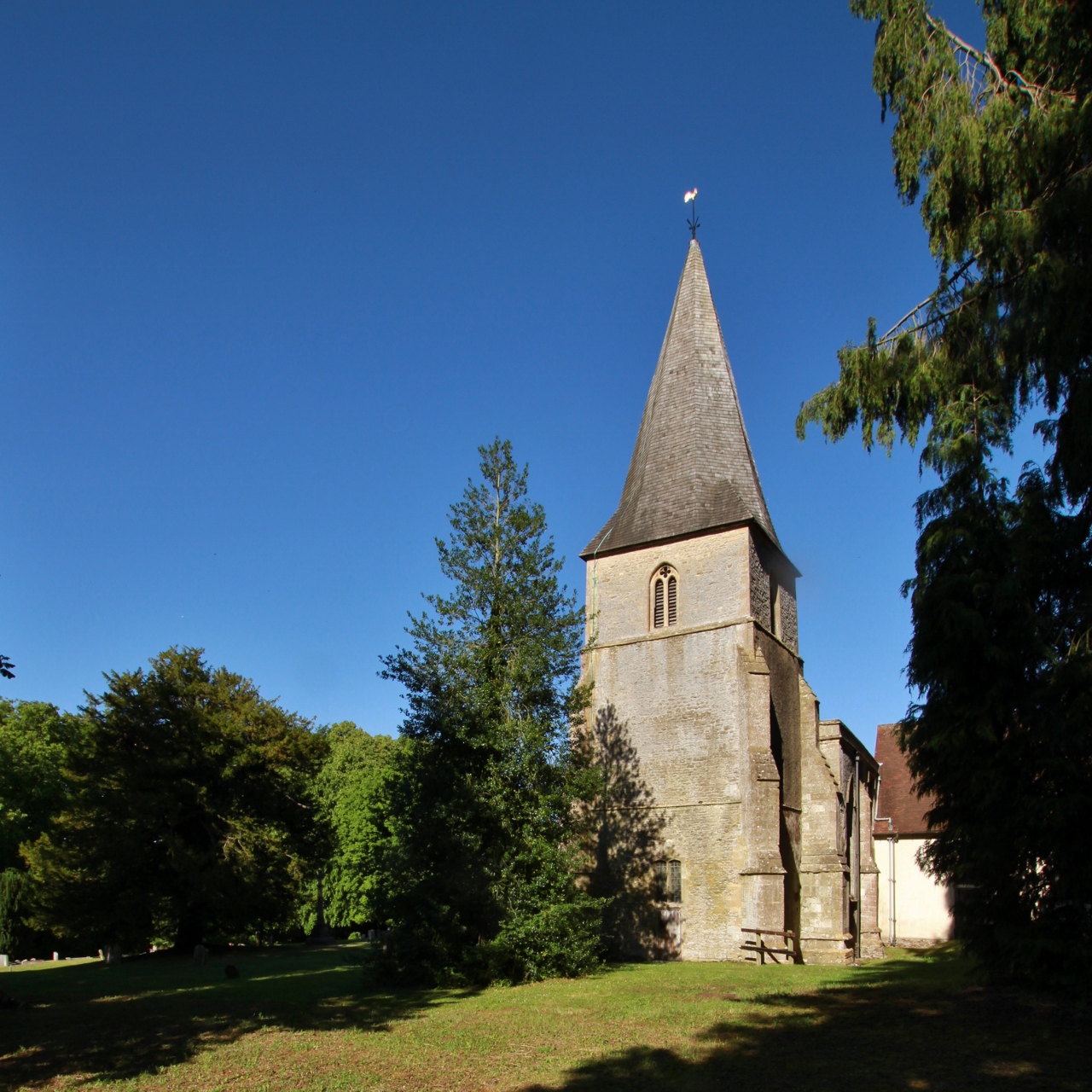
With a population of around 500 residents, Childrey retains its rural charm and offers a peaceful and picturesque setting. The village is characterized by its traditional thatched cottages and historic buildings, which reflect its long-standing heritage. The parish church of St. Mary the Virgin, dating back to the 12th century, stands as a prominent feature in the village and showcases beautiful architectural details.

The village benefits from a strong community spirit, with various social events and activities organized throughout the year. Childrey also has a primary school, providing education for children in the area. Additionally, there is a local pub, The Chequers, which serves as a hub for both residents and visitors.

Surrounded by rolling hills and stunning countryside, Childrey offers ample opportunities for outdoor pursuits and nature walks. The nearby Ridgeway National Trail, an ancient path that stretches for 87 miles, is a popular route for hikers and nature enthusiasts. The surrounding area also boasts several other attractions, including the Uffington White Horse and Wayland's Smithy, both within easy reach.

Overall, Childrey offers a tranquil and idyllic village lifestyle, with a strong sense of community and a wealth of natural beauty to explore.

If you have any feedback on the listing, please let us know in the comments section below.

Childrey Images

Images are sourced within 2km of 51.585865/-1.479766 or Grid Reference SU3687. Thanks to Geograph Open Source API. All images are credited.

Letcombe Bassett bridleway A bridleway that runs from Bassett Road to Green Road (a byway).
Letcombe Bassett bridleway
A bridleway that runs from Bassett Road to Green Road (a byway).
Letcombe Bassett Field farmland Farmland on Letcombe Bassett Field.
Letcombe Bassett Field farmland
Farmland on Letcombe Bassett Field.
Letcombe Bassett Field farmland Farmland on Letcombe Bassett Field, next to a bridleway.
Letcombe Bassett Field farmland
Farmland on Letcombe Bassett Field, next to a bridleway.
Letcombe Bassett bridleway A bridleway that runs from Bassett Road to Green Road (a byway).
Letcombe Bassett bridleway
A bridleway that runs from Bassett Road to Green Road (a byway).
Letcombe Bassett bridleway A bridleway that runs from Bassett Road to Green Road (a byway).
Letcombe Bassett bridleway
A bridleway that runs from Bassett Road to Green Road (a byway).
Letcombe Bassett bridleway A bridleway that runs from Bassett Road to Green Road (a byway).
Letcombe Bassett bridleway
A bridleway that runs from Bassett Road to Green Road (a byway).
Letcombe Bassett bridleway A bridleway that runs from Bassett Road to Green Road (a byway).
Letcombe Bassett bridleway
A bridleway that runs from Bassett Road to Green Road (a byway).
Farmland by Green Road Farmland by Green Road (a byway).
Farmland by Green Road
Farmland by Green Road (a byway).
Farmland off Green Road Farmland beside Green Road (a byway).
Farmland off Green Road
Farmland beside Green Road (a byway).
Green Road Green Road is a byway between Middleway Bottom (the B4001) and an unnamed lane near Letcombe Regis.
Green Road
Green Road is a byway between Middleway Bottom (the B4001) and an unnamed lane near Letcombe Regis.
Green Road Green Road is a byway between Middleway Bottom (the B4001) and an unnamed lane near Letcombe Regis.
Green Road
Green Road is a byway between Middleway Bottom (the B4001) and an unnamed lane near Letcombe Regis.
Green Road Green Road is a byway between Middleway Bottom (the B4001) and an unnamed lane near Letcombe Regis.
Green Road
Green Road is a byway between Middleway Bottom (the B4001) and an unnamed lane near Letcombe Regis.
Overhanging dog rose on Green Road Green Road is a byway between Middleway Bottom (the B4001) and an unnamed lane near Letcombe Regis.
Overhanging dog rose on Green Road
Green Road is a byway between Middleway Bottom (the B4001) and an unnamed lane near Letcombe Regis.
Green Road Green Road is a byway between Middleway Bottom (the B4001) and an unnamed lane near Letcombe Regis.
Green Road
Green Road is a byway between Middleway Bottom (the B4001) and an unnamed lane near Letcombe Regis.
Farmland off Green Road Farmland near to Green Road, a byway.
Farmland off Green Road
Farmland near to Green Road, a byway.
Green Road Green Road is a byway between Middleway Bottom (the B4001) and an unnamed lane near Letcombe Regis.
Green Road
Green Road is a byway between Middleway Bottom (the B4001) and an unnamed lane near Letcombe Regis.
Green Road Green Road is a byway between Middleway Bottom (the B4001) and an unnamed lane near Letcombe Regis.
Green Road
Green Road is a byway between Middleway Bottom (the B4001) and an unnamed lane near Letcombe Regis.
Green Road Green Road is a byway between Middleway Bottom (the B4001) and an unnamed lane near Letcombe Regis.
Green Road
Green Road is a byway between Middleway Bottom (the B4001) and an unnamed lane near Letcombe Regis.
Show me another place!

Childrey is located at Grid Ref: SU3687 (Lat: 51.585865, Lng: -1.479766)

Administrative County: Oxfordshire

District: Vale of White Horse

Police Authority: Thames Valley

What 3 Words

///total.positives.ropes. Near Wantage, Oxfordshire

Nearby Locations

Childrey

Related Wikis

West Challow

West Challow is a village and civil parish about 2 miles (3 km) west of the market town of Wantage in the Vale of White Horse. The village is on Childrey...

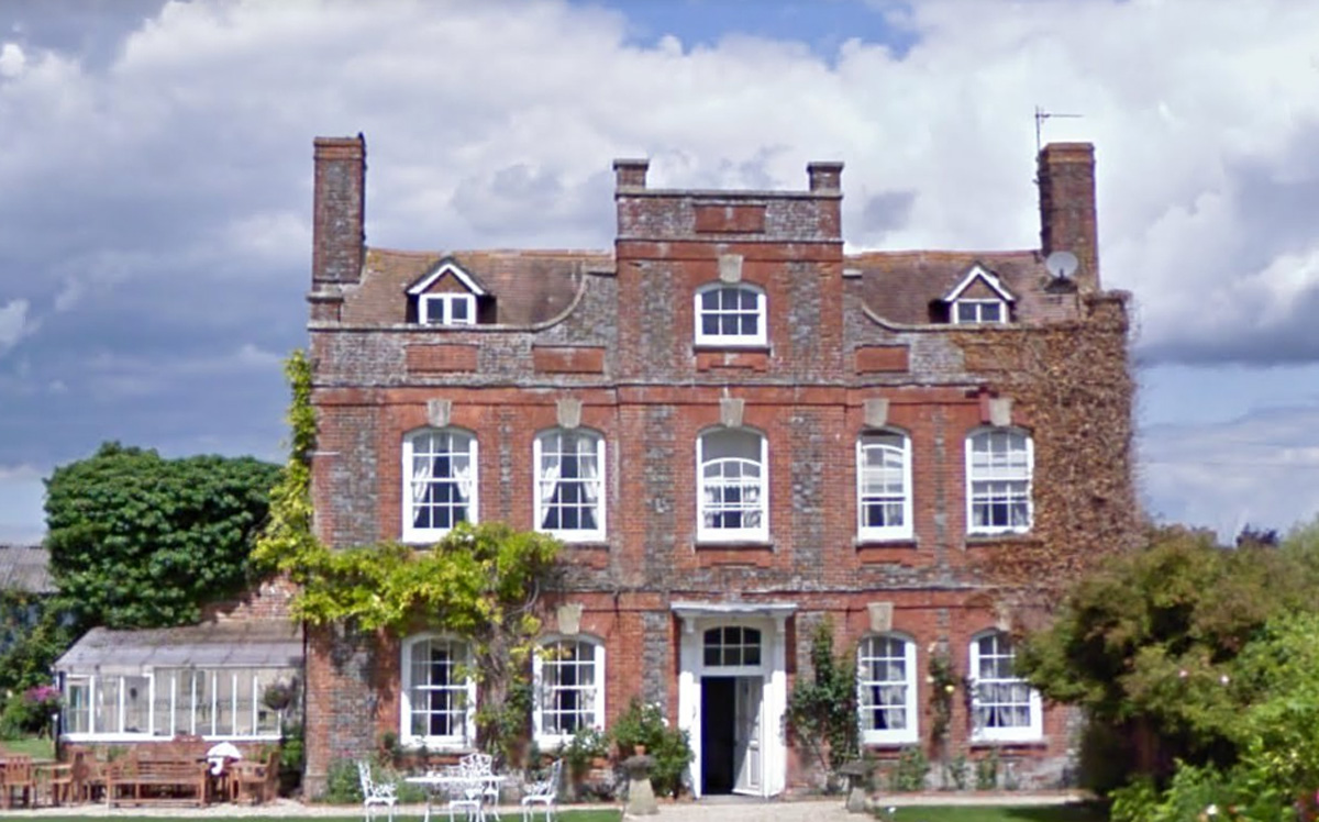
Manor Farm, West Challow

Manor Farm in West Challow, Oxfordshire, England, is a building of historical significance and is Grade II listed on the English Heritage Register. It...

Sparsholt, Oxfordshire

Sparsholt is a village and civil parish about 3 miles (5 km) west of Wantage in the Vale of White Horse district of Oxfordshire. The parish includes the...

Letcombe F.C.

Letcombe Football Club is a football club based in Letcombe Regis, Oxfordshire, England. They are currently member of the Hellenic League Division Two...

East Challow

East Challow is a village and civil parish about 1 mile (1.6 km) west of Wantage in the Vale of White Horse, England. Historically it was part of the ecclesiastical...

Childrey

Childrey is a village and civil parish about 2+1⁄2 miles (4 km) west of Wantage in the Vale of White Horse. The parish was part of the Wantage Rural District...

Reed Hill, Oxfordshire

Reed Hill is a 14-hectare (35-acre) biological Site of Special Scientific Interest (SSSI) west of Stonesfield in Oxfordshire. It partly overlaps Stonesfield...
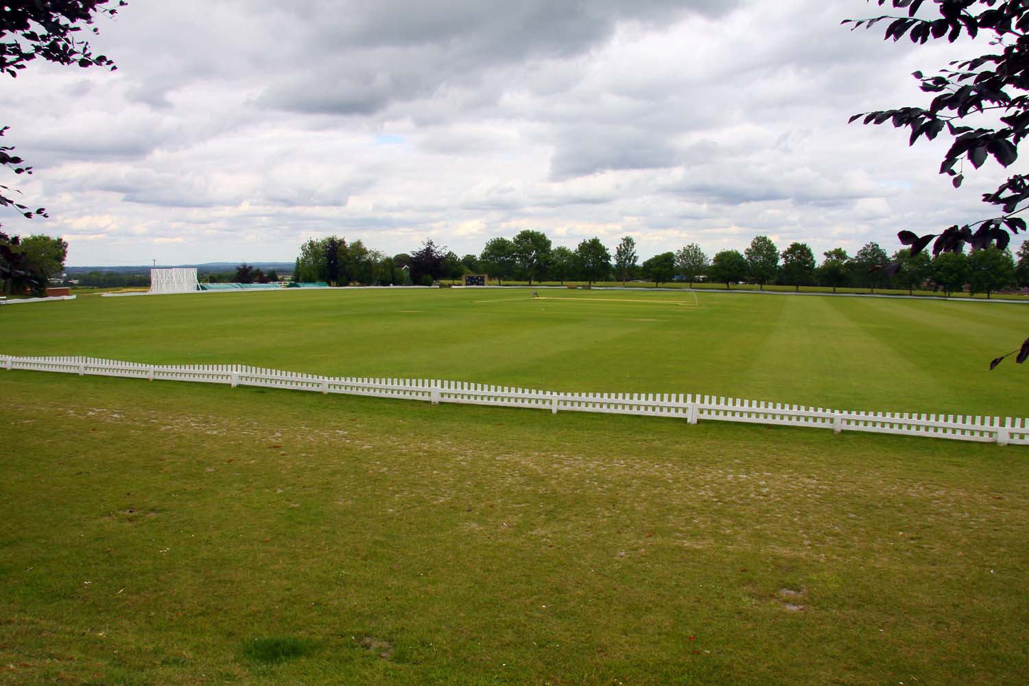
Vicarage Hill

Vicarage Hill is a cricket ground located in East Challow, Oxfordshire. Situated on the site of a park which has been in existence since the 1890s, the...

Nearby Amenities

Located within 500m of 51.585865,-1.479766
Turning Circle
Lat/Long: 51.5868925/-1.4780267
Childrey
Place: village
Wikidata: Q2654971
Lat/Long: 51.5852379/-1.4795427
Bus Stop
Village Hall
Naptan AtcoCode: 340000196OPP
Naptan Bearing: N
Naptan CommonName: Village Hall
Naptan Indicator: Opposite
Naptan Landmark: Village Hall
Naptan NaptanCode: oxfgmptw
Naptan Street: High Street
Naptan Verified: no
Public Transport: platform
Shelter: no
Source: naptan_import
Lat/Long: 51.5852775/-1.4797136
Bus Stop
Village Hall
Naptan AtcoCode: 340000196VH
Naptan Bearing: S
Naptan CommonName: Village Hall
Naptan Indicator: Outside
Naptan Landmark: Village Hall
Naptan NaptanCode: oxfajtgm
Naptan Street: High Street
Naptan Verified: no
Public Transport: platform
Shelter: no
Source: naptan_import
Lat/Long: 51.5856456/-1.4796083
Bus Stop
The Hatchet Pub
Naptan AtcoCode: 340001074DOL
Naptan Bearing: N
Naptan CommonName: The Hatchet Pub
Naptan Indicator: Opposite
Naptan Landmark: The Hatchet Pub
Naptan NaptanCode: oxfagapg
Naptan Street: High Street
Naptan Verified: no
Public Transport: platform
Source: naptan_import
Lat/Long: 51.5840286/-1.4799443
Bus Stop
The Hatchet Pub
Naptan AtcoCode: 340001074OUT
Naptan Bearing: S
Naptan CommonName: The Hatchet Pub
Naptan Indicator: Outside
Naptan Landmark: The Hatchet Pub
Naptan NaptanCode: oxfagapd
Naptan Street: High Street
Naptan Verified: no
Public Transport: platform
Shelter: no
Source: naptan_import
Lat/Long: 51.5837321/-1.479991
Cafe
Coffee Corner
Addr City: Childrey
Addr Housename: Coffee Corner
Addr Postcode: OX12 9UE
Addr Street: High Street
Description: Coffee and fresh cakes & soup daily.
Internet Access: wlan
Opening Hours: Th-Fr 08:30-16:00; Sa 08:30-00:30
Smoking: outside
Lat/Long: 51.5840183/-1.4800317
Power: pole
Source: Bing
Lat/Long: 51.5895077/-1.4811879
Power: pole
Source: Bing
Lat/Long: 51.5891869/-1.4790917
Power: pole
Source: Bing
Lat/Long: 51.589001/-1.478011
Power: pole
Source: Bing
Lat/Long: 51.589372/-1.4802008
Power: pole
Source: Bing
Lat/Long: 51.5882094/-1.4857985
Power: pole
Source: Bing
Lat/Long: 51.5888095/-1.4769196
Power: pole
Source: Bing
Lat/Long: 51.5891309/-1.4760743
Power: pole
Source: Bing
Lat/Long: 51.5896643/-1.4824861
Post Box
Post Box Type: lamp
Royal Cypher: EIIR
Royal Cypher Wikidata: Q33102113
Lat/Long: 51.5842883/-1.4798071
The data included in this document is from www.openstreetmap.org. The data is made available under ODbL.

Have you been to Childrey?

Leave your review of Childrey below (or comments, questions and feedback).