Anchor Wood

Wood, Forest in Devon North Devon

England

Anchor Wood

Brannam Pottery, Barnstaple This is a bit of a landmark in Barnstaple and produces terra cotta pots for the garden centres etc.
Brannam Pottery, Barnstaple Credit: Mike Crowe

Anchor Wood is a picturesque woodland area located in Devon, England. It is known for its natural beauty and diverse flora and fauna. Covering an area of approximately 100 acres, the wood is part of a larger forest complex and is surrounded by rolling hills and meadows.

The wood is predominantly made up of deciduous trees such as oak, beech, and ash, which create a stunning canopy of greenery in the summer months. In the autumn, the wood comes alive with vibrant hues of red, orange, and gold as the leaves change color.

Walking trails wind through Anchor Wood, allowing visitors to explore its hidden treasures. The trails vary in difficulty, catering to both casual strollers and avid hikers. Along the way, one may encounter various species of birds, including woodpeckers and owls, as well as small mammals like squirrels and foxes.

Wildflowers are abundant in Anchor Wood, with carpets of bluebells and primroses adorning the forest floor in springtime. The wood also boasts a small stream that meanders through its heart, providing a tranquil spot for visitors to relax and enjoy the peaceful sounds of nature.

Anchor Wood is a popular destination for nature lovers, photographers, and families seeking an escape from the hustle and bustle of everyday life. Its serene atmosphere and beautiful surroundings make it a haven for wildlife and a true gem in the Devon landscape.

If you have any feedback on the listing, please let us know in the comments section below.
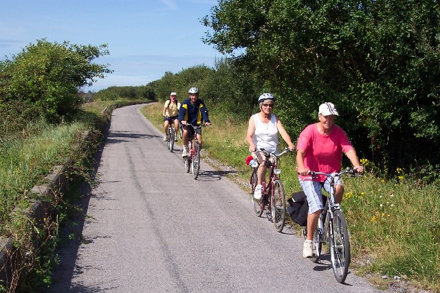
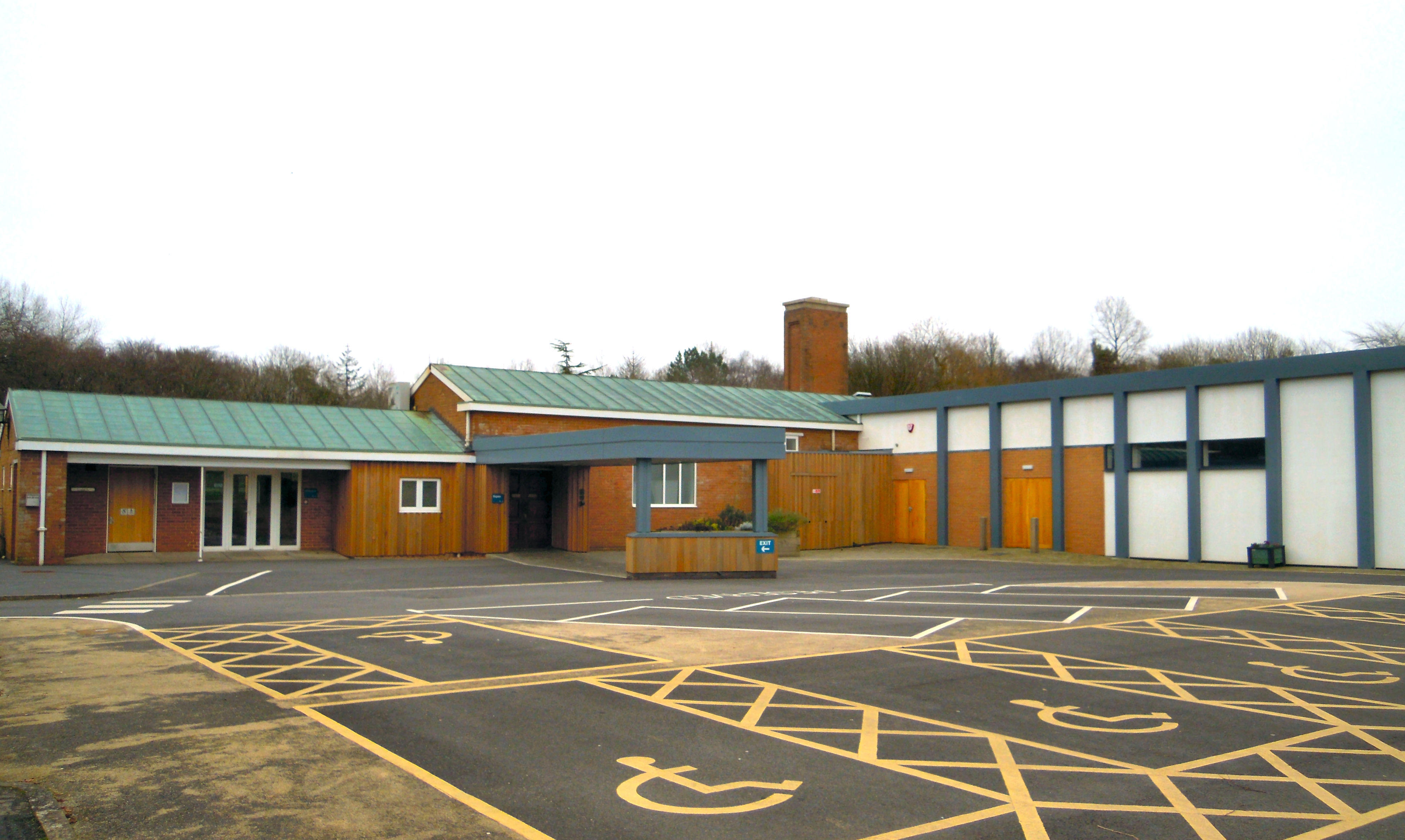
Anchor Wood Images

Images are sourced within 2km of 51.076476/-4.0839432 or Grid Reference SS5432. Thanks to Geograph Open Source API. All images are credited.

Brannam Pottery, Barnstaple This is a bit of a landmark in Barnstaple and produces terra cotta pots for the garden centres etc.
Brannam Pottery, Barnstaple
This is a bit of a landmark in Barnstaple and produces terra cotta pots for the garden centres etc.
The River Yeo in Barnstaple
Shelter on Tarka Trail between Fremington and Barnstaple This intriguing shelter has been defaced by spray-can artists.
Shelter on Tarka Trail between Fremington and Barnstaple
This intriguing shelter has been defaced by spray-can artists.
Mudflats by river Taw near Barnstaple
Civic Centre, Barnstaple, from south bank of river Taw
Cyclists on the Tarka Trail This photograph is a bit of a cheat. I wanted a picture of a big group of cyclists but the lady in the front came along well ahead of her friends. So I took two pictures and assembled them together. Unfortunately my cut and paste missed part of the shadow of the front bike wheel!
Cyclists on the Tarka Trail
This photograph is a bit of a cheat. I wanted a picture of a big group of cyclists but the lady in the front came along well ahead of her friends. So I took two pictures and assembled them together. Unfortunately my cut and paste missed part of the shadow of the front bike wheel!
Bridge over Pottington Creek, Barnstaple This stylish modern bridge was built to replace Pottington Swing Bridge which was demolished after the Barnstaple to Ilfracombe railway closed.
Bridge over Pottington Creek, Barnstaple
This stylish modern bridge was built to replace Pottington Swing Bridge which was demolished after the Barnstaple to Ilfracombe railway closed.
Barnstaple Long Bridge Barnstaple Long Bridge was built in the 14th century  and is still the main river crossing for several miles. However a new bridge is being built slightly downstream to take much of the passing traffic out of the town centre. It is expected to open in 2006.
Barnstaple Long Bridge
Barnstaple Long Bridge was built in the 14th century and is still the main river crossing for several miles. However a new bridge is being built slightly downstream to take much of the passing traffic out of the town centre. It is expected to open in 2006.
The Iron Bridge, Barnstaple The Iron bridge used to carry the link between the ex-Great Western Railway and Southern Railway lines in Barnstaple. This allowed GW trains from Taunton  to continue through to Ilfracombe. Despite the line closing in the early 1960s and the value of the metal for scrap, the bridge survived to become a pedestrian and cycle bridge.
The Iron Bridge, Barnstaple
The Iron bridge used to carry the link between the ex-Great Western Railway and Southern Railway lines in Barnstaple. This allowed GW trains from Taunton to continue through to Ilfracombe. Despite the line closing in the early 1960s and the value of the metal for scrap, the bridge survived to become a pedestrian and cycle bridge.
The Tarka Trail near Barnstaple The Tarka Trail running alongside the River Taw just downstream of Barnstaple.
The Tarka Trail near Barnstaple
The Tarka Trail running alongside the River Taw just downstream of Barnstaple.
Barnstaple Long Bridge on a crisp morning. I'm not sure what the word for this stuff is - the mist that rises from a river on a cold morning - but it looks pretty.
Barnstaple Long Bridge on a crisp morning.
I'm not sure what the word for this stuff is - the mist that rises from a river on a cold morning - but it looks pretty.
Folly on Poleshill Taken from the end of Poleshill Lane.
Folly on Poleshill
Taken from the end of Poleshill Lane.
View of Barnstaple from Poleshill Lane Codden Hill <a href="https://www.geograph.org.uk/gridref/SS5829">SS5829</a> in the distance.
View of Barnstaple from Poleshill Lane
Codden Hill SS5829 in the distance.
View of Bradiford from Poleshill Lane
Almshouses and Church, Pilton Pevsner says that these Almshouses were built in 1849 in 'pretty-imitation Tudor' style. St Mary's Church is behind them.
Almshouses and Church, Pilton
Pevsner says that these Almshouses were built in 1849 in 'pretty-imitation Tudor' style. St Mary's Church is behind them.
Taw Estuary and South West Coastpath The Tarka Trail / South West Coastpath near where Bradiford Water joins the River Taw.
Taw Estuary and South West Coastpath
The Tarka Trail / South West Coastpath near where Bradiford Water joins the River Taw.
New Road Bridge over the Taw Under construction (Mar 2006), this bridge is part of the new western bypass for the town.
New Road Bridge over the Taw
Under construction (Mar 2006), this bridge is part of the new western bypass for the town.
Long Bridge Plaque inscription says "Barnstaple Long Bridge, Ministry of Transport, built in the 13th century, widened about 1796 and again in 1963"
Long Bridge
Plaque inscription says "Barnstaple Long Bridge, Ministry of Transport, built in the 13th century, widened about 1796 and again in 1963"
Show me another place!

Anchor Wood is located at Grid Ref: SS5432 (Lat: 51.076476, Lng: -4.0839432)

Administrative County: Devon

District: North Devon

Police Authority: Devon and Cornwall

What 3 Words

///educates.uppermost.lasts. Near Barnstaple, Devon

Nearby Locations

Anchor Wood

Related Wikis

Fresh FM (Petroc)

Fresh FM (formerly Acorn FM) is a student-run radio station based at the Barnstaple campus of Petroc, a further education college in North Devon, England...

North Devon College

North Devon College was a further education college in Barnstaple, North Devon. It is now part of Petroc. == History == North Devon College (NDC) first...

East Devon College

East Devon College (sometimes shortened to EDC) was a further education college situated in Tiverton, Devon, England. The college operated on four sites...

Barnstaple Town F.C.

Barnstaple Town Football Club is a football club based in Barnstaple, Devon, England. They are currently members of the Western League Premier Division...

Pottington Road Ground

The Pottington Road Ground also known as the North Devon Greyhound Stadium is a rugby union ground and former greyhound racing stadium in Pottington Road...

North Devon Crematorium

The North Devon Crematorium (also known as Barnstaple Crematorium) is located on Old Torrington Road in Barnstaple and is the only crematorium in North...

Braunton Road rail accident

The Braunton Road railway accident occurred on 1 January 1910 in England. The Lynton & Barnstaple Railway maintained an exemplary safety record throughout...

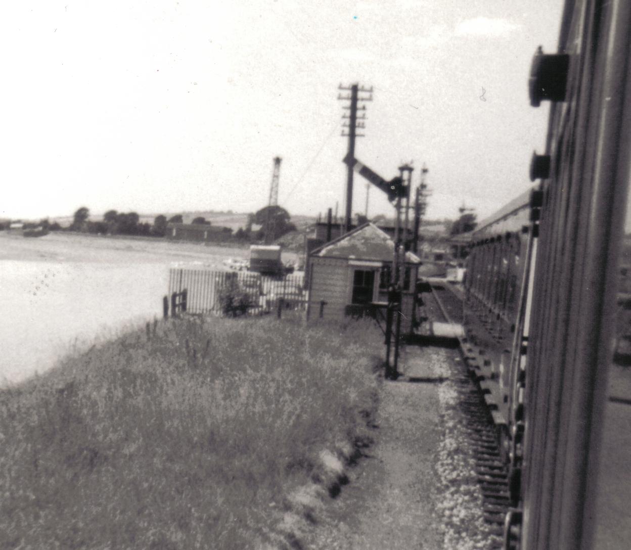
Barnstaple Quay railway station

Barnstaple Quay was an intermediate station on the L&SWR line to Ilfracombe in Devon, England. The station opened in 1874, and located on the north bank...

Nearby Amenities

Located within 500m of 51.076476,-4.0839432
Source: Landsat photo
Lat/Long: 51.0772429/-4.0786293
Source: Landsat photo
Lat/Long: 51.0776406/-4.0808394
Source: Landsat photo
Lat/Long: 51.077553/-4.0804639
Source: Landsat photo
Lat/Long: 51.0780451/-4.0830388
Source: Landsat photo
Lat/Long: 51.0784029/-4.0845465
Source: Landsat photo
Lat/Long: 51.078914/-4.0855881
Source: Landsat photo
Lat/Long: 51.0794667/-4.0861246
Source: Landsat photo
Lat/Long: 51.0799385/-4.086661
Barrier: kissing_gate
Lat/Long: 51.075677/-4.082822
Barrier: kissing_gate
Source: walked with GPS
Lat/Long: 51.0747519/-4.0779182
Pub
Cedars Inn
Addr City: Barnstaple
Addr County: Devon
Addr Postcode: EX31 2HE
Addr Suburb: Sticklepath
Brand: Greene King
Brand Wikidata: Q5564162
Fhrs Id: 161414
Source Addr: FHRS Open Data
Website: https://www.greeneking.co.uk/pubs/devon/cedars-inn
Lat/Long: 51.0731374/-4.0854215
Generator Method: photovoltaic
Generator Output Electricity: yes
Generator Source: solar
Generator Type: solar_photovoltaic_panel
Location: roof
Power: generator
Lat/Long: 51.0733238/-4.088657
Direction: S
Generator Method: photovoltaic
Generator Output Electricity: yes
Generator Solar Modules: 14
Generator Source: solar
Generator Type: solar_photovoltaic_panel
Location: roof
Power: generator
Lat/Long: 51.0736944/-4.0864809
Direction: S
Generator Method: photovoltaic
Generator Output Electricity: yes
Generator Solar Modules: 16
Generator Source: solar
Generator Type: solar_photovoltaic_panel
Location: roof
Power: generator
Lat/Long: 51.0744848/-4.0847986
Direction: 185
Generator Method: photovoltaic
Generator Output Electricity: yes
Generator Solar Modules: 9
Generator Source: solar
Generator Type: solar_photovoltaic_panel
Location: roof
Power: generator
Lat/Long: 51.0749285/-4.0871685
Direction: 95
Generator Method: photovoltaic
Generator Output Electricity: yes
Generator Solar Modules: 5
Generator Source: solar
Generator Type: solar_photovoltaic_panel
Location: roof
Power: generator
Lat/Long: 51.0749082/-4.0872199
Direction: WSW
Generator Method: photovoltaic
Generator Output Electricity: yes
Generator Solar Modules: 11
Generator Source: solar
Generator Type: solar_photovoltaic_panel
Location: roof
Power: generator
Lat/Long: 51.0753751/-4.0861917
Direction: SSW
Generator Method: photovoltaic
Generator Output Electricity: yes
Generator Solar Modules: 16
Generator Source: solar
Generator Type: solar_photovoltaic_panel
Location: roof
Power: generator
Lat/Long: 51.0762265/-4.0859549
Direction: SSW
Generator Method: photovoltaic
Generator Output Electricity: yes
Generator Solar Modules: 14
Generator Source: solar
Generator Type: solar_photovoltaic_panel
Location: roof
Power: generator
Lat/Long: 51.0748613/-4.0811915
Direction: ESE
Generator Method: photovoltaic
Generator Output Electricity: yes
Generator Solar Modules: 8
Generator Source: solar
Generator Type: solar_photovoltaic_panel
Location: roof
Power: generator
Lat/Long: 51.074683/-4.0798597
Direction: WNW
Generator Method: photovoltaic
Generator Output Electricity: yes
Generator Solar Modules: 8
Generator Source: solar
Generator Type: solar_photovoltaic_panel
Location: roof
Power: generator
Lat/Long: 51.0746949/-4.0799123
Direction: 190
Generator Method: photovoltaic
Generator Output Electricity: yes
Generator Solar Modules: 15
Generator Source: solar
Generator Type: solar_photovoltaic_panel
Location: roof
Power: generator
Lat/Long: 51.0751747/-4.0813435
Direction: SSW
Generator Method: photovoltaic
Generator Output Electricity: yes
Generator Solar Modules: 8
Generator Source: solar
Generator Type: solar_photovoltaic_panel
Location: roof
Power: generator
Lat/Long: 51.0757927/-4.0848292
Direction: ESE
Generator Method: photovoltaic
Generator Output Electricity: yes
Generator Solar Modules: 3
Generator Source: solar
Generator Type: solar_photovoltaic_panel
Location: roof
Power: generator
Lat/Long: 51.0757926/-4.0847634
Direction: ESE
Generator Method: photovoltaic
Generator Output Electricity: yes
Generator Solar Modules: 8
Generator Source: solar
Generator Type: solar_photovoltaic_panel
Location: roof
Power: generator
Lat/Long: 51.0763575/-4.086561
Direction: WNW
Generator Method: photovoltaic
Generator Output Electricity: yes
Generator Solar Modules: 8
Generator Source: solar
Generator Type: solar_photovoltaic_panel
Location: roof
Power: generator
Lat/Long: 51.0763425/-4.0866181
Direction: S
Generator Method: photovoltaic
Generator Output Electricity: yes
Generator Solar Modules: 12
Generator Source: solar
Generator Type: solar_photovoltaic_panel
Location: roof
Power: generator
Lat/Long: 51.0766414/-4.0865828
Direction: 175
Generator Method: photovoltaic
Generator Output Electricity: yes
Generator Solar Modules: 12
Generator Source: solar
Generator Type: solar_photovoltaic_panel
Location: roof
Power: generator
Lat/Long: 51.0735821/-4.0861358
Direction: 100
Generator Method: photovoltaic
Generator Output Electricity: yes
Generator Solar Modules: 7
Generator Source: solar
Generator Type: solar_photovoltaic_panel
Location: roof
Power: generator
Lat/Long: 51.0759296/-4.086661
Direction: 190
Generator Method: photovoltaic
Generator Output Electricity: yes
Generator Solar Modules: 9
Generator Source: solar
Generator Type: solar_photovoltaic_panel
Location: roof
Power: generator
Lat/Long: 51.0759356/-4.0867498
Direction: SE
Generator Method: photovoltaic
Generator Output Electricity: yes
Generator Solar Modules: 14
Generator Source: solar
Generator Type: solar_photovoltaic_panel
Location: roof
Power: generator
Lat/Long: 51.0743972/-4.0881628
Power: pole
Lat/Long: 51.0775645/-4.0833548
Power: pole
Lat/Long: 51.0772308/-4.0814906
Power: pole
Lat/Long: 51.0769107/-4.0797231
Power: pole
Lat/Long: 51.0765703/-4.0779018
Power: pole
Lat/Long: 51.0766933/-4.0777932
Power: pole
Lat/Long: 51.077032/-4.0796171
Power: pole
Lat/Long: 51.0773775/-4.0815496
Power: pole
Lat/Long: 51.0777263/-4.0834191
Power: pole
Lat/Long: 51.0785377/-4.0889257
Power: pole
Lat/Long: 51.0782605/-4.0870602
Power: pole
Lat/Long: 51.0779277/-4.085231
Power: pole
Lat/Long: 51.0780827/-4.0853222
Power: pole
Lat/Long: 51.0783852/-4.0869918
Power: pole
Lat/Long: 51.0786817/-4.0888989
Crossing
Lat/Long: 51.0722098/-4.0843061
The data included in this document is from www.openstreetmap.org. The data is made available under ODbL.

Have you been to Anchor Wood?

Leave your review of Anchor Wood below (or comments, questions and feedback).