Chiddingstone Causeway

Settlement in Kent Sevenoaks

England

Chiddingstone Causeway

Fissenden, Hampkins Hill Road, Chiddingstone Understood to have once been an oast house.
Fissenden, Hampkins Hill Road, Chiddingstone Credit: Oast House Archive

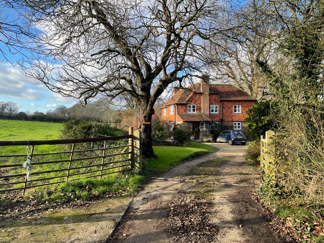
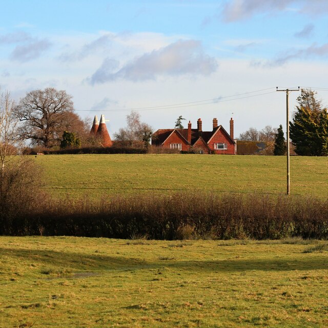
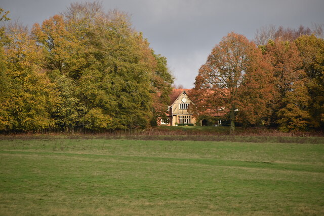
Chiddingstone Causeway is a small village located in the county of Kent, England. Situated approximately 35 miles southeast of London, it forms part of the Sevenoaks district. The village is known for its picturesque countryside setting and traditional English charm.

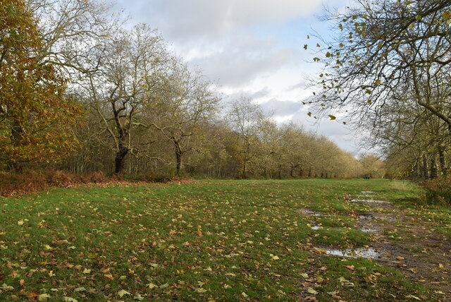
Chiddingstone Causeway is home to a population of around 600 residents, and it is surrounded by lush green fields and woodlands, offering a tranquil and idyllic environment. The village itself features a mix of charming old cottages and more modern houses, giving it a diverse architectural style.

One of the notable landmarks in Chiddingstone Causeway is the Grade II listed St. Luke's Church, which dates back to the 19th century. The church serves as a focal point for the community and holds regular religious services.

The village also benefits from its location near the River Eden, which provides opportunities for outdoor activities such as fishing, boating, and riverside walks. Additionally, there are several designated footpaths and bridleways in the area, making it popular with hikers and cyclists.

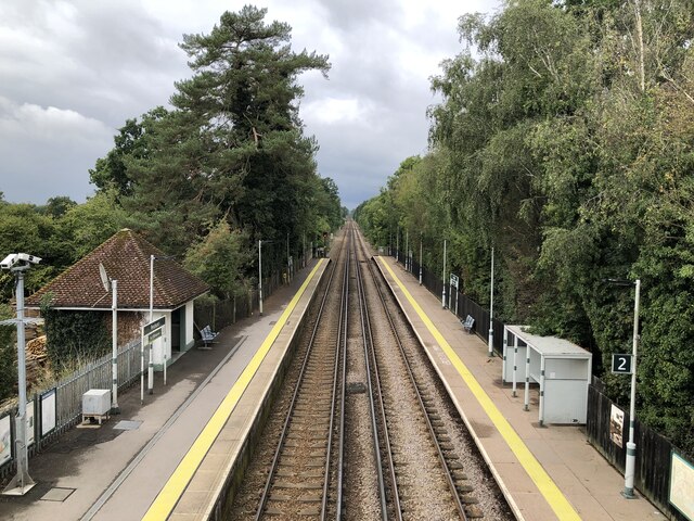
Chiddingstone Causeway is well-connected to surrounding areas via road links, with the A21 passing nearby, providing easy access to the nearby towns of Sevenoaks and Tonbridge. The village is served by a local bus service, offering transportation options for residents and visitors.

Overall, Chiddingstone Causeway offers a peaceful and picturesque setting, making it an attractive place for those seeking a rural retreat while still having access to nearby amenities and transport links.

If you have any feedback on the listing, please let us know in the comments section below.

Chiddingstone Causeway Images

Images are sourced within 2km of 51.199079/0.173194 or Grid Reference TQ5146. Thanks to Geograph Open Source API. All images are credited.

Fissenden, Hampkins Hill Road, Chiddingstone Understood to have once been an oast house.
Fissenden, Hampkins Hill Road, Chiddingstone
Understood to have once been an oast house.
Fissenden, Hampkins Hill Road, Chiddingstone Understood to have once been an oast house.
Fissenden, Hampkins Hill Road, Chiddingstone
Understood to have once been an oast house.
Becketts Farm
Becketts Farm
West Wood from the air The wood forms an elongated S shape along the course of Copping's Gill.
West Wood from the air
The wood forms an elongated S shape along the course of Copping's Gill.
Penshurst Railway Station As of 2022 the station is operated by Southern, with an hourly service in each direction running between Tonbridge and Redhill.
Penshurst Railway Station
As of 2022 the station is operated by Southern, with an hourly service in each direction running between Tonbridge and Redhill.
Becketts Farm Oast Twin round kiln oast house.
Becketts Farm Oast
Twin round kiln oast house.
Becketts Farm Oast Twin round kiln oast house.
Becketts Farm Oast
Twin round kiln oast house.
Wooded pond
Wooded pond
Penshurst Station
Penshurst Station
Path and trees, Penshurst Park
The Mount
The Mount
Footpath, Penshurst Park Penshurst Park, is the parkland that surrounds Penshurst Place a 14th century manor house belonging to the Sidney Family. Beyond the parkland are extensive deciduous and conifer woodlands. It  is part of the larger Penshurst Estate, that includes farmland.
Footpath, Penshurst Park
Penshurst Park, is the parkland that surrounds Penshurst Place a 14th century manor house belonging to the Sidney Family. Beyond the parkland are extensive deciduous and conifer woodlands. It is part of the larger Penshurst Estate, that includes farmland.
Footpath waymarker
Footpath waymarker
Penshurst Park Penshurst Park, is the parkland that surrounds Penshurst Place a 14th century manor house belonging to the Sidney Family. Beyond the parkland are extensive deciduous and conifer woodlands. It  is part of the larger Penshurst Estate, that includes farmland.
Penshurst Park
Penshurst Park, is the parkland that surrounds Penshurst Place a 14th century manor house belonging to the Sidney Family. Beyond the parkland are extensive deciduous and conifer woodlands. It is part of the larger Penshurst Estate, that includes farmland.
Coppicing Coppicing is a management technique of cutting trees and shrubs to ground level allowing vigorous regrowth and a sustainable supply of timber for future generations. 
Trees and shrubs that are cut down in this way can produce shoots that grow over 30cm in a week.
The benefits of coppicing are varied, including promoting ground vegetation (by letting light in), raw materials for thatching, fencing, kindling and charcoal making. Also coppiced trees live longer than non coppiced trees. All trees can be coppiced, but hazel, ash, lime and beech are common.
Coppicing
Coppicing is a management technique of cutting trees and shrubs to ground level allowing vigorous regrowth and a sustainable supply of timber for future generations. Trees and shrubs that are cut down in this way can produce shoots that grow over 30cm in a week. The benefits of coppicing are varied, including promoting ground vegetation (by letting light in), raw materials for thatching, fencing, kindling and charcoal making. Also coppiced trees live longer than non coppiced trees. All trees can be coppiced, but hazel, ash, lime and beech are common.
Show me another place!

Chiddingstone Causeway is located at Grid Ref: TQ5146 (Lat: 51.199079, Lng: 0.173194)

Administrative County: Kent

District: Sevenoaks

Police Authority: Kent

What 3 Words

///sadly.wakes.stay. Near Speldhurst, Kent

Nearby Locations

Chiddingstone Causeway

Related Wikis

Chiddingstone Causeway

Chiddingstone Causeway is a village 4 miles (6 km) west of Tonbridge in Kent, England. It is within the Sevenoaks local government district. It is in the...

Penshurst railway station

Penshurst railway station is on the Redhill to Tonbridge Line and is located approximately two miles north of Penshurst in Kent, in the village of Chiddingstone...

St Luke's Church, Chiddingstone Causeway

St Luke's is a Grade II* listed Church of England church in Chiddingstone Causeway, Kent. It was built in 1897–1898 to a design by John Francis Bentley...

Penshurst Airfield

Penshurst Airfield was an airfield in operation between 1916–36 and 1940–46. Initially a military airfield, after the First World War it was used as an...

Nearby Amenities

Located within 500m of 51.199079,0.173194
Penshurst
Addr Postcode: TN11 8JE
Naptan AtcoCode: 9100PNSHRST
Network: National Rail
Network Website: https://www.nationalrail.co.uk/stations/phr/
Network Wikidata: Q26334
Public Transport: station
Railway: station
Ref Crs: PHR
Wheelchair: yes
Wikidata: Q2675582
Wikipedia: en:Penshurst railway station
Lat/Long: 51.1972229/0.1734867
Chiddingstone Causeway
Place: village
Wikidata: Q5096601
Lat/Long: 51.1976697/0.1762345
Pub
Little Brown Jug
Addr City: Tonbridge
Addr Postcode: TN11 8JJ
Addr Street: Chiddingstone Causeway
Fhrs Id: 266541
Opening Hours: Mo-Fr 10:00-23:00; Sa 09:00-23:30; Su 09:00-22:00
Outdoor Seating: yes
Source Addr: FHRS Open Data
Wikimedia Commons: File:Little_Brown_Jug_pub,_Chiddingstone_Causeway_(July_2012).JPG
Lat/Long: 51.1977712/0.1740009
Bus Stop
Cricket Ground
Naptan AtcoCode: 2400A007400A
Naptan Bearing: NW
Naptan CommonName: Cricket Ground
Naptan Indicator: adj
Naptan Landmark: Cricket Ground
Naptan NaptanCode: kntajmja
Naptan Street: High Street
Naptan Verified: yes
Public Transport: platform
Ref: kntajmja
Source: naptan_import
Source Date: 2018-06-26
Lat/Long: 51.1986313/0.170155
Bus Stop
Cricket Ground
Bus: yes
Naptan AtcoCode: 2400A007410A
Naptan Bearing: SE
Naptan CommonName: Cricket Ground
Naptan Indicator: opp
Naptan Landmark: Cricket Ground
Naptan NaptanCode: kntajmjd
Naptan Street: High Street
Naptan Verified: yes
Public Transport: platform
Ref: kntajmjd
Source: naptan_import
Source Date: 2018-06-26
Lat/Long: 51.1983023/0.1716027
Bus Stop
The Greyhound
Naptan AtcoCode: 2400A035380A
Naptan Bearing: W
Naptan CommonName: The Greyhound
Naptan Indicator: nr
Naptan Landmark: The Greyhound Ph
Naptan NaptanCode: kntdmjda
Naptan Street: Main Street
Naptan Verified: no
Public Transport: platform
Ref: kntdmjda
Source: naptan_import
Source Date: 2014-01-28T11:56:00
Lat/Long: 51.2018715/0.1767921
Bus Stop
Penshurst Railway Station
Flag: no
Naptan AtcoCode: 2400A035400A
Naptan Bearing: S
Naptan BusStopType: CUS
Naptan CommonName: Penshurst Railway Station
Naptan Indicator: adj
Naptan Landmark: Stn
Naptan NaptanCode: kntdmjdj
Naptan Street: Penshurst Station Hill
Naptan Verified: no
Public Transport: platform
Source: naptan_import
Lat/Long: 51.196935/0.1735788
Bus Stop
Penshurst Railway Station
Flag: no
Naptan AtcoCode: 2400A060950R
Naptan Bearing: W
Naptan BusStopType: CUS
Naptan CommonName: Penshurst Railway Station
Naptan Indicator: o/s
Naptan Landmark: Entrance To Platform
Naptan NaptanCode: kntgdadg
Naptan Street: B2027
Naptan Verified: yes
Public Transport: platform
Source: naptan_import
Lat/Long: 51.1972815/0.1738099
Post Office
Chiddingstone Causeway Post Office
Addr Postcode: TN11 8JP
Branch: Chiddingstone Causeway
Brand: Post Office
Brand Wikidata: Q1783168
Check Date: 2020-02-20
Contact Website: https://www.postoffice.co.uk/branch-finder/1539485/chiddingstone-causeway
Ref Pol Id: 3109
Lat/Long: 51.1986901/0.1698037
Railway: crossing
Source: Bing
Lat/Long: 51.197647/0.1694898
Barrier: stile
Lat/Long: 51.2016455/0.1732608
Building: bunker
Bunker Type: pillbox
Military: bunker
Lat/Long: 51.1985347/0.1772508
Telephone
Defibrillator
Booth: K6
Covered: booth
Defibrillator Location: inside old red phone box by Causeway Stores, Chiddingstone Causeway
Emergency: defibrillator
Indoor: no
Man Made: telephone_box
Lat/Long: 51.1987344/0.1700707
Historic: memorial
Memorial: war_memorial
Lat/Long: 51.1976183/0.1758322
Penshurst
Public Transport: stop_position
Railway: stop
Train: yes
Lat/Long: 51.1973012/0.1727695
Penshurst
Public Transport: stop_position
Railway: stop
Train: yes
Lat/Long: 51.1972375/0.1736634
Post Box
Collection Times: Mo-Fr 16:45; Sa 10:00
Post Box Type: wall
Ref: TN11 147
Royal Cypher: EIIR
Royal Cypher Wikidata: Q33102113
Lat/Long: 51.1988121/0.1698218
Waste Basket
Waste: dog_excrement
Lat/Long: 51.1985794/0.1701174
The data included in this document is from www.openstreetmap.org. The data is made available under ODbL.

Have you been to Chiddingstone Causeway?

Leave your review of Chiddingstone Causeway below (or comments, questions and feedback).