Blindwell Wood

Wood, Forest in Cornwall

England

Blindwell Wood

Former Bible Christian Chapel
Former Bible Christian Chapel Credit: Paul Barnett

Blindwell Wood is a picturesque woodland located in Cornwall, England. Covering an area of approximately 50 acres, it is a popular destination for nature lovers, hikers, and photographers. The wood is situated near the village of Stithians, offering visitors a tranquil and serene environment to explore.

As one ventures into Blindwell Wood, they are greeted by an enchanting mix of broadleaf and coniferous trees, creating a diverse and vibrant ecosystem. The woodland is home to a wide array of flora and fauna, including oak, beech, and ash trees, as well as various species of birds, butterflies, and small mammals.

Numerous walking trails wind through the wood, providing visitors with the opportunity to immerse themselves in its natural beauty. These paths are well-maintained and suitable for people of all ages and abilities. Along the way, one can discover hidden clearings, babbling brooks, and even a small pond, adding to the charm and allure of the wood.

Blindwell Wood is particularly stunning during the spring and autumn seasons when the trees don their vibrant hues of green and gold. The woodland also boasts a rich display of wildflowers, creating a colorful carpet that blankets the forest floor.

Whether seeking a peaceful retreat or an adventure in nature, Blindwell Wood offers a delightful experience for all who visit. Its idyllic setting, diverse wildlife, and well-maintained trails make it a must-visit destination for anyone exploring the natural wonders of Cornwall.

If you have any feedback on the listing, please let us know in the comments section below.

Blindwell Wood Images

Images are sourced within 2km of 50.465725/-4.2570524 or Grid Reference SX3965. Thanks to Geograph Open Source API. All images are credited.
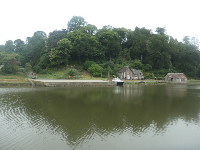
Former Bible Christian Chapel
St Mallanus's Church
Drive to St Mellion Estate
Gates to Briston Orchard The entrance to Briston Farmhouse is on the left.
Gates to Briston Orchard
The entrance to Briston Farmhouse is on the left.
Road to Polborder off the A388
Marshy edge of the Hooe peninsula On the Devon bank of the River Tamar.
Marshy edge of the Hooe peninsula
On the Devon bank of the River Tamar.
Salt marsh on the Hooe peninsula On the Devon bank of the River Tamar.
Salt marsh on the Hooe peninsula
On the Devon bank of the River Tamar.
Boat moored on the Tamar, downstream of North Hooe The rising tide makes the boat point downstream.
Boat moored on the Tamar, downstream of North Hooe
The rising tide makes the boat point downstream.
Chapel Farm, north of Halton Quay On the Cornish side of the River Tamar.
Chapel Farm, north of Halton Quay
On the Cornish side of the River Tamar.
Hilton Quay, River Tamar There are many small quays along the tidal river, dating from the time when the river was the main [perhaps only] freight route in this area.
Hilton Quay, River Tamar
There are many small quays along the tidal river, dating from the time when the river was the main [perhaps only] freight route in this area.
Boat moored at Pentillie Quay On the Cornish side of the River Tamar.
Boat moored at Pentillie Quay
On the Cornish side of the River Tamar.
The Church of St Melanus at St Mellion Viewed from the north-east.
The Church of St Melanus at St Mellion
Viewed from the north-east.
Ordnance Survey Cut Mark This can be found on the wall of St Melanus Church at St Mellion.
For more detail see : <span class="nowrap"><a title="http://www.bench-marks.org.uk/bm71192" rel="nofollow ugc noopener" href="http://www.bench-marks.org.uk/bm71192">Link</a><img style="margin-left:2px;" alt="External link" title="External link - shift click to open in new window" src="https://s1.geograph.org.uk/img/external.png" width="10" height="10"/></span>
Ordnance Survey Cut Mark
This can be found on the wall of St Melanus Church at St Mellion. For more detail see : LinkExternal link
Old Milestone by the A388, St Mellion Carved stone post by the A388, in parish of ST MELLION (CARADON District), East of The Glebe, on the verge on bend clear of hedge, on East side of road. Callington C gravestone, erected by the Callington turnpike trust in the 18th century. 

Inscription reads:-
3½
C
Carved benchmark on front face.

Grade II Listed. List Entry Number: 1329047
<span class="nowrap"><a title="https://historicengland.org.uk/listing/the-list/list-entry/1329047" rel="nofollow ugc noopener" href="https://historicengland.org.uk/listing/the-list/list-entry/1329047">Link</a><img style="margin-left:2px;" alt="External link" title="External link - shift click to open in new window" src="https://s1.geograph.org.uk/img/external.png" width="10" height="10"/></span>

Milestone Society National ID: CW_CLSH03.
Old Milestone by the A388, St Mellion
Carved stone post by the A388, in parish of ST MELLION (CARADON District), East of The Glebe, on the verge on bend clear of hedge, on East side of road. Callington C gravestone, erected by the Callington turnpike trust in the 18th century. Inscription reads:- 3½ C Carved benchmark on front face. Grade II Listed. List Entry Number: 1329047 LinkExternal link Milestone Society National ID: CW_CLSH03.
Old Milestone by the former A388, Paynter's Cross Carved stone post by the UC road (was A388), in parish of PILLATON (CARADON District), Paynters Cross, not on line of old road, on South side of road. Callington C gravestone, erected by the Callington turnpike trust in the 18th century. 

Inscription reads:-
4½
C 

Grade II Listed. List Entry Number: 1392533
<span class="nowrap"><a title="https://historicengland.org.uk/listing/the-list/list-entry/1392533" rel="nofollow ugc noopener" href="https://historicengland.org.uk/listing/the-list/list-entry/1392533">Link</a><img style="margin-left:2px;" alt="External link" title="External link - shift click to open in new window" src="https://s1.geograph.org.uk/img/external.png" width="10" height="10"/></span>

Milestone Society National ID: CW_CLSH04.
Old Milestone by the former A388, Paynter's Cross
Carved stone post by the UC road (was A388), in parish of PILLATON (CARADON District), Paynters Cross, not on line of old road, on South side of road. Callington C gravestone, erected by the Callington turnpike trust in the 18th century. Inscription reads:- 4½ C Grade II Listed. List Entry Number: 1392533 LinkExternal link Milestone Society National ID: CW_CLSH04.
Lane to Sillaton
Lane to Sillaton
Field by A388
Field by A388
Gorse bushes by A388
Show me another place!

Blindwell Wood is located at Grid Ref: SX3965 (Lat: 50.465725, Lng: -4.2570524)

Unitary Authority: Cornwall

Police Authority: Devon and Cornwall

What 3 Words

///shunning.arts.sprayer. Near Pillaton, Cornwall

Related Wikis

Halton Barton

Halton Barton is a farm in the parish of St Dominic in Cornwall, England. == See also == List of farms in Cornwall == References ==

Polborder

Polborder is a hamlet south of St Mellion in Cornwall, England. == References ==

St Mellion

St Mellion (Cornish: Sen Melyan) is a village and rural civil parish in east Cornwall, England, United Kingdom. The parish is about 3 miles (5 km) south...

Paynter's Cross

Paynter's Cross is a hamlet on the A388 main road southeast of St Mellion in southeast Cornwall, England, UK. == References ==

Nearby Amenities

Located within 500m of 50.465725,-4.2570524
Tremoan
Place: hamlet
Source: OS_OpenData_StreetView
Lat/Long: 50.4649488/-4.2632846
The data included in this document is from www.openstreetmap.org. The data is made available under ODbL.

Have you been to Blindwell Wood?

Leave your review of Blindwell Wood below (or comments, questions and feedback).