Eastvenn Plantations

Wood, Forest in Devon Torridge

England

Eastvenn Plantations

Field near Hunscott Chapel It looks as if deer fencing is necessary to surround the grounds of the chapel, which is just off to the right. In the background is the edge of a large area of plantations, unnamed on maps.
Field near Hunscott Chapel Credit: Derek Harper

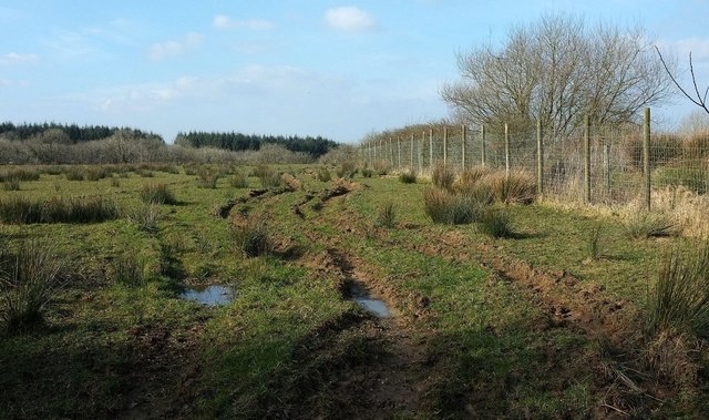
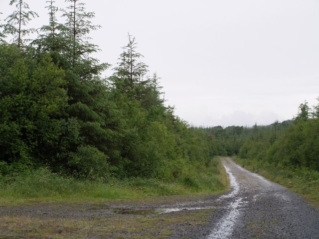
Eastvenn Plantations, located in Devon, England, is a sprawling woodland area that spans several acres. This enchanting forest is known for its lush vegetation, diverse flora, and captivating wildlife, making it a popular destination for nature enthusiasts and hikers alike.

The woodland is predominantly composed of deciduous and coniferous trees, such as oak, beech, pine, and spruce, which create a vibrant and picturesque landscape throughout the year. This mix of tree species provides a rich habitat for numerous animals, including deer, foxes, badgers, and a variety of bird species, making it a prime location for wildlife enthusiasts and birdwatchers.

In addition to its natural beauty, Eastvenn Plantations boasts a network of well-maintained walking trails that wind their way through the forest, offering visitors the opportunity to explore its hidden gems and discover its many wonders. These trails cater to all levels of fitness and provide breathtaking views of the surrounding countryside.

Eastvenn Plantations also offers educational programs and guided tours for those interested in learning more about the forest's ecology and conservation efforts. These initiatives aim to raise awareness about the importance of preserving and protecting this unique natural habitat.

Overall, Eastvenn Plantations is a captivating woodland retreat that showcases the splendor of nature in the heart of Devon. With its diverse flora and fauna, picturesque trails, and educational opportunities, it remains a cherished destination for nature lovers and a testament to the beauty of the English countryside.

If you have any feedback on the listing, please let us know in the comments section below.

Eastvenn Plantations Images

Images are sourced within 2km of 50.760738/-4.2818148 or Grid Reference SX3998. Thanks to Geograph Open Source API. All images are credited.

Field near Hunscott Chapel It looks as if deer fencing is necessary to surround the grounds of the chapel, which is just off to the right. In the background is the edge of a large area of plantations, unnamed on maps.
Field near Hunscott Chapel
It looks as if deer fencing is necessary to surround the grounds of the chapel, which is just off to the right. In the background is the edge of a large area of plantations, unnamed on maps.
Bendibus Hill Cross I took <a href="https://www.geograph.org.uk/photo/468663">SX3899 : Bendibus Hill Cross</a> on a miserable summer day nearly nine years ago; here it is on a lovely day with winter just turning into spring. I didn't notice before that the name on the signpost is just "Bendibus Cross"; maps disagree with each other. Bendibus Hill is the lane opposite which drops to cross a tributary of the Claw. The name "bendibus" is used also for a wood to the northwest, and was obviously created by a precognitive clairvoyant whose only mistake was to assume that the articulated bus would find its way to this remote area of Devon rather than its usual urban environment.
Bendibus Hill Cross
I took SX3899 : Bendibus Hill Cross on a miserable summer day nearly nine years ago; here it is on a lovely day with winter just turning into spring. I didn't notice before that the name on the signpost is just "Bendibus Cross"; maps disagree with each other. Bendibus Hill is the lane opposite which drops to cross a tributary of the Claw. The name "bendibus" is used also for a wood to the northwest, and was obviously created by a precognitive clairvoyant whose only mistake was to assume that the articulated bus would find its way to this remote area of Devon rather than its usual urban environment.
Lane past Rowan Park From the same spot as <a href="https://www.geograph.org.uk/photo/4865685">SX3999 : Field near Hunscott Chapel</a>, looking right.
Lane past Rowan Park
From the same spot as SX3999 : Field near Hunscott Chapel, looking right.
Middle Quoditch Devon Cottage Small Devon hamlet on the road towards Hallwil
Middle Quoditch Devon Cottage
Small Devon hamlet on the road towards Hallwil
Quoditch
Quoditch
Sprys Shop, road junction
Sandymoor Cross, road junction
Thorney Cross, road junction
Field near Broadleaf Farm From the lane between Hunscott and Quoditch Cross.
Field near Broadleaf Farm
From the lane between Hunscott and Quoditch Cross.
Lane near East Down From the same spot as <a href="https://www.geograph.org.uk/photo/4865670">SX4099 : Field near Broadleaf Farm</a>, looking along the lane towards Quoditch Cross.
Lane near East Down
From the same spot as SX4099 : Field near Broadleaf Farm, looking along the lane towards Quoditch Cross.
Sandymoor Cross A major lane, from Holsworthy to Broadwoodwidger, crosses a minor lane from Chapmans Well to Halwill. In spite of the sunshine, this was taken in pouring rain.
Sandymoor Cross
A major lane, from Holsworthy to Broadwoodwidger, crosses a minor lane from Chapmans Well to Halwill. In spite of the sunshine, this was taken in pouring rain.
Buckhorn Methodist Church No date visible for the building. The lane goes from Sandymoor Cross to Claw Bridge.
Buckhorn Methodist Church
No date visible for the building. The lane goes from Sandymoor Cross to Claw Bridge.
Bendibus Hill Cross A lane junction at the top of Bendibus Hill, which is the lane straight ahead. The lane across links Clawford Cross and Halwill. The lane to the left of the camera has come from Sandynoor Cross.
Bendibus Hill Cross
A lane junction at the top of Bendibus Hill, which is the lane straight ahead. The lane across links Clawford Cross and Halwill. The lane to the left of the camera has come from Sandynoor Cross.
Field at East Down Evidence of recent activity in this field - probably the removal of the hay crop before the rain could damage it. Behind the hedge is a field access track leading towards Langaford Moor. Taken from a gateway on the lane from Sandynoor Cross to Halwill.
Field at East Down
Evidence of recent activity in this field - probably the removal of the hay crop before the rain could damage it. Behind the hedge is a field access track leading towards Langaford Moor. Taken from a gateway on the lane from Sandynoor Cross to Halwill.
Quoditchmoor Plantations The scene at a crossroads of rides in this large area of accessible woodland. On the left is a turning circle.
Quoditchmoor Plantations
The scene at a crossroads of rides in this large area of accessible woodland. On the left is a turning circle.
Sandymoor Cross A close-up of the signpost seen in <a href="https://www.geograph.org.uk/photo/468585">SX3898 : Sandymoor Cross</a>, kneedeep in long wet grass.
Sandymoor Cross
A close-up of the signpost seen in SX3898 : Sandymoor Cross, kneedeep in long wet grass.
Thorney Cross The main lane leads from Ashmill to Sandymoor Cross; the lane to the left has come from Ashwater. The farm is Southlands.
Thorney Cross
The main lane leads from Ashmill to Sandymoor Cross; the lane to the left has come from Ashwater. The farm is Southlands.
Bassetts One of several straight stretches on the road between Ashmill and Sandymoor Cross. The corrugated iron on the farm outbuildings sports an attractive shade of green.
Bassetts
One of several straight stretches on the road between Ashmill and Sandymoor Cross. The corrugated iron on the farm outbuildings sports an attractive shade of green.
Show me another place!

Eastvenn Plantations is located at Grid Ref: SX3998 (Lat: 50.760738, Lng: -4.2818148)

Administrative County: Devon

District: Torridge

Police Authority: Devon and Cornwall

What 3 Words

///fuels.brownish.regarding. Near Holsworthy, Devon

Related Wikis

Quoditch

Quoditch is a hamlet in the parish of Ashwater, part of the Torridge district of Devon, England. Its nearest town is Holsworthy, which lies approximately...

Ashwater railway station

Ashwater railway station was a railway station that served the hamlets of Ashwater and Ashmill in Devon, England. It was located on the North Cornwall...

Ashwater

Ashwater is a village and civil parish in the Torridge district of Devon, England. According to the 2001 census it had a population of 651 that had risen...

Halwill

Halwill is a village and civil parish in the Torridge district, in Devon, England just off the A3079 Okehampton to Holsworthy road. About a mile away on...

Have you been to Eastvenn Plantations?

Leave your review of Eastvenn Plantations below (or comments, questions and feedback).