Barleysplat Wood

Wood, Forest in Cornwall

England

Barleysplat Wood

Old Boundary Markers on Warleggan Common Two boundary stones in the gorse and bracken scrub 120 metres west of the lane crossing Warleggan Common. Warleggan parish.

On the right is estate boundary marker CW_WARL19em. One of 5 roughly cut granite stones marked on their eastern face with the letters BC. The Tithe Apportionment shows that the land to the west of these stones is described as “allotment on Common” with the landowner being William Bickford Coham. Four of these stones have been located. Shown on the 6" map of 1907 and on the 1839 Tithe map and Apportionment of Warleggan Parish.

On the left is mine boundary marker CW_WARL20em. One of 3 surviving almost identical stones, marked T on their eastern faces, that are thought to mark the extent of the nearby Treveddoe mine sett.
Old Boundary Markers on Warleggan Common Credit: P G Moore

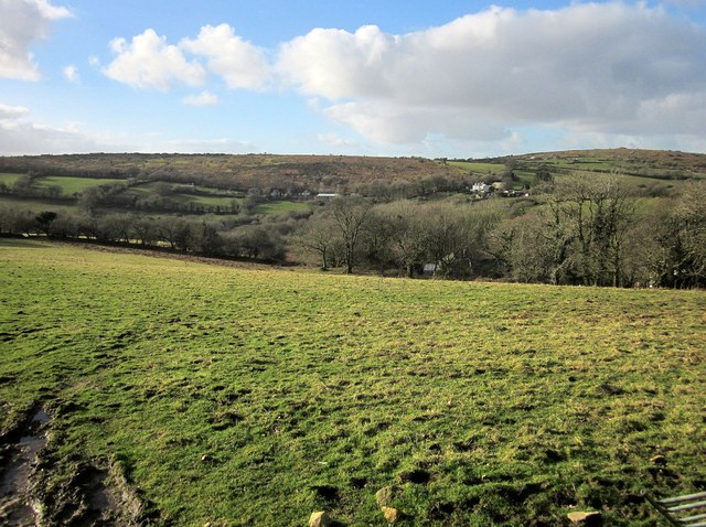
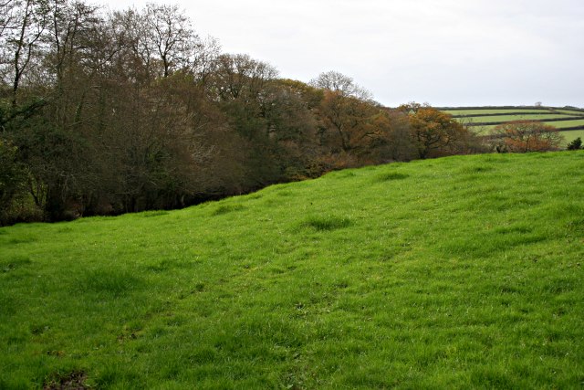
Barleysplat Wood is a picturesque woodland located in Cornwall, England. Covering an area of approximately 50 acres, it is known for its rich biodiversity and stunning natural beauty. The wood is situated on the outskirts of a small village, providing a tranquil escape from the hustle and bustle of everyday life.

The woodland is predominantly made up of oak and beech trees, which create a dense canopy, allowing only dappled sunlight to filter through to the forest floor. This creates a unique and enchanting atmosphere, perfect for nature lovers and photographers alike. The forest floor is covered in a thick carpet of moss, ferns, and wildflowers, adding to the woodland's charm.

Barleysplat Wood is home to a wide variety of wildlife, making it a popular spot for birdwatching and nature walks. Visitors may spot species such as woodpeckers, owls, and even the elusive red squirrel. The woodland also supports a diverse range of plant life, including bluebells, primroses, and foxgloves, which create a vibrant display during the spring and summer months.

The wood is crisscrossed with a network of well-maintained trails, making it easily accessible for walkers and hikers of all abilities. These paths lead visitors through the heart of the wood, offering glimpses of hidden ponds, babbling brooks, and ancient stone walls. There are also designated picnic areas and benches for those who wish to take a break and soak in the peaceful surroundings.

Barleysplat Wood is a true gem in the Cornwall countryside, offering visitors a chance to immerse themselves in nature and experience the beauty of an ancient woodland.

If you have any feedback on the listing, please let us know in the comments section below.

Barleysplat Wood Images

Images are sourced within 2km of 50.485941/-4.5957191 or Grid Reference SX1568. Thanks to Geograph Open Source API. All images are credited.

Old Boundary Markers on Warleggan Common Two boundary stones in the gorse and bracken scrub 120 metres west of the lane crossing Warleggan Common. Warleggan parish.

On the right is estate boundary marker CW_WARL19em. One of 5 roughly cut granite stones marked on their eastern face with the letters BC. The Tithe Apportionment shows that the land to the west of these stones is described as “allotment on Common” with the landowner being William Bickford Coham. Four of these stones have been located. Shown on the 6" map of 1907 and on the 1839 Tithe map and Apportionment of Warleggan Parish.

On the left is mine boundary marker CW_WARL20em. One of 3 surviving almost identical stones, marked T on their eastern faces, that are thought to mark the extent of the nearby Treveddoe mine sett.
Old Boundary Markers on Warleggan Common
Two boundary stones in the gorse and bracken scrub 120 metres west of the lane crossing Warleggan Common. Warleggan parish. On the right is estate boundary marker CW_WARL19em. One of 5 roughly cut granite stones marked on their eastern face with the letters BC. The Tithe Apportionment shows that the land to the west of these stones is described as “allotment on Common” with the landowner being William Bickford Coham. Four of these stones have been located. Shown on the 6" map of 1907 and on the 1839 Tithe map and Apportionment of Warleggan Parish. On the left is mine boundary marker CW_WARL20em. One of 3 surviving almost identical stones, marked T on their eastern faces, that are thought to mark the extent of the nearby Treveddoe mine sett.
Warleggan Down Looking towards Tor House
Warleggan Down
Looking towards Tor House
Old Workhorse Abandoned Morris Minor van, one of several in nearby woodland
Old Workhorse
Abandoned Morris Minor van, one of several in nearby woodland
Pasture at Tamar Farm One of the buildings at Tamar Farm can be discerned through the trees across this pasture. Across the valley below Warleggan Down are Down House, and Castle Dewey (right).
Pasture at Tamar Farm
One of the buildings at Tamar Farm can be discerned through the trees across this pasture. Across the valley below Warleggan Down are Down House, and Castle Dewey (right).
Old Boundary Marker Estate Boundary Marker on Warleggan Down. WARLEGGAN parish. Inscribed B / C, perhaps for William Bickford Coham.

Milestone Society National ID: CW_WARL17em
Old Boundary Marker
Estate Boundary Marker on Warleggan Down. WARLEGGAN parish. Inscribed B / C, perhaps for William Bickford Coham. Milestone Society National ID: CW_WARL17em
Ancient banks of Crowpound, St Neot, Cornwall Legend says that St Neot sent all the crows in the parish, during sermons, to the pound so that local farmers could not excuse themselves from church services.
Ancient banks of Crowpound, St Neot, Cornwall
Legend says that St Neot sent all the crows in the parish, during sermons, to the pound so that local farmers could not excuse themselves from church services.
Lane and Trees This country lane is brightened up by the red Autumn foliage of an ornamental tree in a nearby private garden.
Lane and Trees
This country lane is brightened up by the red Autumn foliage of an ornamental tree in a nearby private garden.
Inquisitive Sheep "You looking at me?"
Inquisitive Sheep
"You looking at me?"
Juncus Meadow Dark Juncus grasses grow in the waterlogged sections of this pasture.
Juncus Meadow
Dark Juncus grasses grow in the waterlogged sections of this pasture.
Pasture and Woodland There are still a few Autumn leaves left on the trees but the mild November weather is letting the grass grow sparkling green.
Pasture and Woodland
There are still a few Autumn leaves left on the trees but the mild November weather is letting the grass grow sparkling green.
Pantersbridge The old bridge on the right was built in the 15th century.  This used to be the main road between Bodmin and Liskeard before the 1830's when a new road was constructed through the Glynn Valley to the south.
Pantersbridge
The old bridge on the right was built in the 15th century. This used to be the main road between Bodmin and Liskeard before the 1830's when a new road was constructed through the Glynn Valley to the south.
Warleggan River This river is also known as The Bedalder River.  It takes a fairly steep course to meet the River Fowey in the Glynn Valley south of here.
Warleggan River
This river is also known as The Bedalder River. It takes a fairly steep course to meet the River Fowey in the Glynn Valley south of here.
Blocked Field Gate It is fairly common practice for local farmers to block unused gates with whatever comes to hand.
Blocked Field Gate
It is fairly common practice for local farmers to block unused gates with whatever comes to hand.
Minor Road Junction
Minor Road Junction
St Bartholomew, Warleggan The church is dedicated to St Bartholomew. The church was one of the few on Bodmin Moor to have a spire, until in 1818 when it was struck by lightning. Until a road was built in 1953 linking it to the A38, it had the reputation of being one of the most remote areas of Cornwall.
The priest from 1931 until his death in 1953 was Frederick Densham. Frederick, to say the least, was an eccentric: painting the church and vicarage in garish colours. All his parishioners eventually shunned the church and poor old Frederick preached his sermon's to "cut out cardboard figures" seated around the church. In 1953, many years after he had preached to his last “live” congregation, Rev Densham’s body was found in a crumpled heap at the bottom of the stairs at the rectory. A book by Daphne du Maurier was based on this story.
St Bartholomew, Warleggan
The church is dedicated to St Bartholomew. The church was one of the few on Bodmin Moor to have a spire, until in 1818 when it was struck by lightning. Until a road was built in 1953 linking it to the A38, it had the reputation of being one of the most remote areas of Cornwall. The priest from 1931 until his death in 1953 was Frederick Densham. Frederick, to say the least, was an eccentric: painting the church and vicarage in garish colours. All his parishioners eventually shunned the church and poor old Frederick preached his sermon's to "cut out cardboard figures" seated around the church. In 1953, many years after he had preached to his last “live” congregation, Rev Densham’s body was found in a crumpled heap at the bottom of the stairs at the rectory. A book by Daphne du Maurier was based on this story.
Sunnyside Forge A business in the hamlet of Mount.
Sunnyside Forge
A business in the hamlet of Mount.
Premature flowers on rape A field by the road south of Mount
Premature flowers on rape
A field by the road south of Mount
Primitive Fridge This small building was once used to keep food cool. A spring bubbles up on the floor whilst slate shelves would have been used to place the food on...the door is long gone.
Primitive Fridge
This small building was once used to keep food cool. A spring bubbles up on the floor whilst slate shelves would have been used to place the food on...the door is long gone.
Show me another place!

Barleysplat Wood is located at Grid Ref: SX1568 (Lat: 50.485941, Lng: -4.5957191)

Unitary Authority: Cornwall

Police Authority: Devon and Cornwall

What 3 Words

///smallest.pickup.buckling. Near Dobwalls, Cornwall

Related Wikis

Pantersbridge

Pantersbridge (Cornish: Pons Yesu, meaning Jesus Bridge)is a hamlet in the parish of St Neot, Cornwall, England, UK. It is about one mile south of Warleggan...

Warleggan

Warleggan or Warleggon (Cornish: Gorlegan) is a civil parish on the southern edge of Bodmin Moor in Cornwall, England, United Kingdom. The parish is roughly...

Mount, Cornwall

Mount is a village in the parish of Warleggan in east Cornwall, England. It lies south-west of Warleggan village. == References ==

Cornwall National Landscape

The Cornwall National Landscape (formerly the Cornwall Area of Outstanding Natural Beauty) covers 958 square kilometres (370 sq mi) in Cornwall, England...

Nearby Amenities

Located within 500m of 50.485941,-4.5957191
Bus Stop
Panter's Bridge
Naptan AtcoCode: 0800FWX38765
Naptan Bearing: E
Naptan CommonName: Panter's Bridge
Naptan NaptanCode: cordpajd
Naptan Street: Unclassified
Naptan Verified: no
Source: naptan_import
Lat/Long: 50.4828795/-4.5969457
Bus Stop
Panter's Bridge
Naptan AtcoCode: 0800FWX38766
Naptan Bearing: W
Naptan CommonName: Panter's Bridge
Naptan NaptanCode: cordpaja
Naptan Street: Unclassified
Naptan Verified: no
Source: naptan_import
Lat/Long: 50.4827717/-4.5969397
Pantersbridge
Is In County: Cornwall
Place: hamlet
Source: NPE
Wikidata: Q7131706
Lat/Long: 50.4824916/-4.5946598
Ford: yes
Lat/Long: 50.4847757/-4.5955646
Ford: yes
Lat/Long: 50.4874111/-4.5916358
The data included in this document is from www.openstreetmap.org. The data is made available under ODbL.

Have you been to Barleysplat Wood?

Leave your review of Barleysplat Wood below (or comments, questions and feedback).