Highlaw Wood

Wood, Forest in Berwickshire

Scotland

Highlaw Wood

Swansfield Former farm with overgrown sheep pens at 170m asl overlooking the A1.
Swansfield Credit: Richard Webb

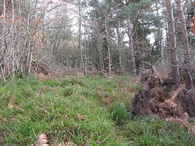
Highlaw Wood is a picturesque woodland located in the rural region of Berwickshire, Scotland. Covering an area of approximately 100 acres, this enchanting forest is known for its diverse ecosystem and stunning natural beauty.

The wood is predominantly composed of broadleaf trees, such as oak, beech, and ash, which create a dense and vibrant canopy. These trees provide a habitat for a wide variety of flora and fauna, including wildflowers, ferns, and mosses, as well as numerous bird species and small mammals.

Visitors to Highlaw Wood can explore the network of well-maintained footpaths that wind through the forest, offering a tranquil and peaceful ambiance. The paths meander alongside a small stream that runs through the wood, adding to the serene atmosphere.

The wood is also home to an array of wildlife, making it a popular destination for nature enthusiasts and birdwatchers. Species such as red squirrels, roe deer, and tawny owls can often be spotted among the trees, providing a unique opportunity to observe these creatures in their natural habitat.

Highlaw Wood is easily accessible, with a car park located nearby for visitors' convenience. The wood is open year-round, allowing visitors to experience its beauty in every season. Whether it be the vibrant hues of autumn or the fresh greenery of spring, Highlaw Wood offers a captivating natural experience for all who visit.

If you have any feedback on the listing, please let us know in the comments section below.

Highlaw Wood Images

Images are sourced within 2km of 55.869021/-2.2387558 or Grid Reference NT8564. Thanks to Geograph Open Source API. All images are credited.

Swansfield Former farm with overgrown sheep pens at 170m asl overlooking the A1.
Swansfield
Former farm with overgrown sheep pens at 170m asl overlooking the A1.
Sheep, Swansfield Pastureland above the Eye Water.
Sheep, Swansfield
Pastureland above the Eye Water.
Eye Water Downstream from Howden Bridge.
Eye Water
Downstream from Howden Bridge.
Green Wood Not so green on the day of the Winter Solstice. This is a small Forestry Commission property above Houndwood. The maps are wrong here, a road now runs up through the wood from Houndwood, and the old lane up from the A1 has been closed.
Green Wood
Not so green on the day of the Winter Solstice. This is a small Forestry Commission property above Houndwood. The maps are wrong here, a road now runs up through the wood from Houndwood, and the old lane up from the A1 has been closed.
Houndwood Postbox and local resident.
Houndwood
Postbox and local resident.
A1, Houndwood Underpass and the new section of dual carriageway bypassing Houndwood.
A1, Houndwood
Underpass and the new section of dual carriageway bypassing Houndwood.
Green Wood Forestry Commission woodland above Houndwood. A pleasing mix of trees and dense undergrowth. Full of finches living off the goose and peacock food in the village below.
Green Wood
Forestry Commission woodland above Houndwood. A pleasing mix of trees and dense undergrowth. Full of finches living off the goose and peacock food in the village below.
Ag-bag The mother of all silage bags - Lemington, Berwickshire.
Ag-bag
The mother of all silage bags - Lemington, Berwickshire.
Mount Alban Given the large scale switch to arable agriculture in recent years, how many gates are lying soon to be buried beside fields?
Mount Alban
Given the large scale switch to arable agriculture in recent years, how many gates are lying soon to be buried beside fields?
Greenwood The new road up to Greenwood. Unfortunately the Forestry Commission have neglected to provide adequate parking for electric trains.   

The new road runs up from Houndwood, on the East Coast main line.  It replaces a more direct ascent from the A1 which was closed for safety reasons.
Greenwood
The new road up to Greenwood. Unfortunately the Forestry Commission have neglected to provide adequate parking for electric trains. The new road runs up from Houndwood, on the East Coast main line. It replaces a more direct ascent from the A1 which was closed for safety reasons.
Houndwood Houndwood is now bypassed. View of some of the old A1 road through the village.
Houndwood
Houndwood is now bypassed. View of some of the old A1 road through the village.
Lemington Field recovering through the winter.
Lemington
Field recovering through the winter.
Lemington View over the Eye Water from Lemington.
Lemington
View over the Eye Water from Lemington.
Road to Mount Alban One of many dead end roads off the A1 up to farms on the slopes above the Eye Water.
Road to Mount Alban
One of many dead end roads off the A1 up to farms on the slopes above the Eye Water.
Eye Water and A1 near Houndwood From the train.
Eye Water and A1 near Houndwood
From the train.
A1 near Houndwood From the train.
A1 near Houndwood
From the train.
Houndwood Inn On A1; seen from the railway.
Houndwood Inn
On A1; seen from the railway.
Track North East of Hillend Farm
Show me another place!

Highlaw Wood is located at Grid Ref: NT8564 (Lat: 55.869021, Lng: -2.2387558)

Unitary Authority: The Scottish Borders

Police Authority: The Lothians and Scottish Borders

What 3 Words

///pacifist.sitting.opinion. Near Chirnside, Scottish Borders

Nearby Locations

Highlaw Wood

Related Wikis

Press Castle

Press Castle is a village with 17th-century manor house and country estate in the Scottish Borders, 2m (3 km) west of Coldingham, by the Ale Water. NT871654...

A1107 road

The A1107 is a road in south-east Scotland, in the Scottish Borders. It is a non-trunk route from near Cockburnspath to near Burnmouth. It follows the...

Auchencrow

Auchencrow (Scottish Gaelic: Allt na Crà) is a small village in the Scottish Borders area of Scotland, by the Lammermuir range of hills, and near Reston...

Reston railway station

Reston is a railway station in the small village of Reston that serves the wider rural parish of Coldingham and nearby small town of Eyemouth in the eastern...

Reston, Scottish Borders

Reston is a village located in the southeast of Scotland, in Berwickshire, Scottish Borders region. The village lies on the western bank of the Eye Water...

Billie Castle

Billie Castle is a ruined 15th century quadrangular castle, 3 miles (4.8 km) north west of Chirnside, Scottish Borders, Scotland, north of Billiemains...

Grantshouse

Grantshouse is a small village in Berwickshire in the Scottish Borders of Scotland. It lies on the A1, and its nearest railway stations are Dunbar to the...

Grantshouse railway station

Grantshouse railway station served the village of Grantshouse, Berwickshire, Scotland from 1846 to 1964 on the East Coast Main Line. == History == The...

Nearby Amenities

Located within 500m of 55.869021,-2.2387558
Power: pole
Lat/Long: 55.8656695/-2.2349348
Power: pole
Lat/Long: 55.8657503/-2.2364719
Power: pole
Lat/Long: 55.8660193/-2.238009
Power: pole
Lat/Long: 55.866034/-2.2382261
Power: pole
Lat/Long: 55.8661207/-2.2395117
Power: pole
Lat/Long: 55.8662184/-2.2409349
Power: pole
Lat/Long: 55.8663209/-2.2422076
Power: pole
Lat/Long: 55.8664017/-2.2432674
Power: pole
Lat/Long: 55.8670592/-2.2440564
Power: pole
Lat/Long: 55.8676925/-2.2447938
Power: pole
Lat/Long: 55.8683656/-2.2455892
Power: pole
Lat/Long: 55.8689325/-2.2462428
Power: pole
Lat/Long: 55.8659458/-2.2381573
Power: pole
Lat/Long: 55.8651677/-2.2373211
Power: pole
Lat/Long: 55.8650567/-2.2371878
Power: pole
Lat/Long: 55.8649662/-2.2366288
Power: pole
Lat/Long: 55.8647298/-2.2390409
Power: pole
Lat/Long: 55.8647551/-2.2396794
Power: pole
Lat/Long: 55.864772/-2.2403093
The data included in this document is from www.openstreetmap.org. The data is made available under ODbL.

Have you been to Highlaw Wood?

Leave your review of Highlaw Wood below (or comments, questions and feedback).