Whitewell Plantation

Wood, Forest in Roxburghshire

Scotland

Whitewell Plantation

Old milestone The milestone is just north of the small bridge over the burn at Linton Burnfoot.   This minor road joins the B6401 to cross the Kale Water and then continues southwards along the Kale Water valley to Hownam and beyond.
Old milestone Credit: Chris Minto

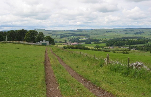
Whitewell Plantation is a picturesque woodland located in Roxburghshire, Scotland. Spanning over a vast area, it is renowned for its breathtaking natural beauty and diverse flora and fauna. The plantation is situated near the village of Whitewell, surrounded by rolling hills and offering stunning views of the Scottish Borders.

The woodland is predominantly composed of a mix of broadleaf and coniferous trees, including oak, beech, pine, and spruce. These trees create a dense canopy, providing shelter and habitats for a variety of wildlife species. Whitewell Plantation is home to numerous bird species, such as woodpeckers, owls, and various songbirds. It is also frequented by small mammals like red squirrels, badgers, and foxes.

The plantation offers a range of recreational activities for visitors to enjoy. There are well-maintained walking trails that wind through the woodland, allowing visitors to explore and appreciate the tranquility of the natural surroundings. The paths are suitable for all abilities and provide an opportunity to spot wildlife and admire the stunning landscape.

Whitewell Plantation is managed by the local forestry commission, ensuring the preservation of its natural heritage and the sustainable use of its resources. As part of conservation efforts, selective logging is carried out to maintain a healthy and balanced ecosystem. The wood harvested from the plantation is used for a variety of purposes, including construction, furniture making, and fuel.

Overall, Whitewell Plantation is a cherished woodland destination in Roxburghshire, offering visitors a chance to immerse themselves in nature, witness diverse wildlife, and indulge in recreational activities amidst breathtaking scenery.

If you have any feedback on the listing, please let us know in the comments section below.

Whitewell Plantation Images

Images are sourced within 2km of 55.540704/-2.3540531 or Grid Reference NT7727. Thanks to Geograph Open Source API. All images are credited.

Old milestone The milestone is just north of the small bridge over the burn at Linton Burnfoot.   This minor road joins the B6401 to cross the Kale Water and then continues southwards along the Kale Water valley to Hownam and beyond.
Old milestone
The milestone is just north of the small bridge over the burn at Linton Burnfoot. This minor road joins the B6401 to cross the Kale Water and then continues southwards along the Kale Water valley to Hownam and beyond.
Old milestone This view southwards towards the B6401 shows the milestone in relation to the bridge over the burn.
Old milestone
This view southwards towards the B6401 shows the milestone in relation to the bridge over the burn.
Old milestone Looking north from the milestone.   The Linton Burnfoot cottages are round the corner in the distance.   This area of the Borders was, prior to the 1970s, in Roxburghshire.
Old milestone
Looking north from the milestone. The Linton Burnfoot cottages are round the corner in the distance. This area of the Borders was, prior to the 1970s, in Roxburghshire.
Old milestone On the B6436 north of Morebattle between Linton Farm and the lane to Crookhouse which is opposite the War Memorial.   Another stone that needed some 'gardening' around it.   Morebattle spelt without an E in the middle.  This part of Borders was Roxburghshire before the 1970s.
Old milestone
On the B6436 north of Morebattle between Linton Farm and the lane to Crookhouse which is opposite the War Memorial. Another stone that needed some 'gardening' around it. Morebattle spelt without an E in the middle. This part of Borders was Roxburghshire before the 1970s.
Old milestone Looking northwards from the milestone the War Memorial is just out of sight beyond the bend.
Old milestone
Looking northwards from the milestone the War Memorial is just out of sight beyond the bend.
Lintonhill Farm on the slopes of Linton Hill
Lintonhill
Farm on the slopes of Linton Hill
Summit of Linton Hill Silage being cut before a view of the Cheviots.
Summit of Linton Hill
Silage being cut before a view of the Cheviots.
Linton Kirk A lovely little spot on an elevated position - great views all round!
Linton Kirk
A lovely little spot on an elevated position - great views all round!
Radio Mast on Linton Hill
Field at Crookhouse, Morebattle. Picking your own vegetables
Field at Crookhouse, Morebattle.
Picking your own vegetables
Minor road junction near Greenlees
Rocky Outcrop / Quarry
Farmland and plantation near Frogden
Frogden
Frogden
View over cropped field towards Linton Hill
Looking for Briggs and Reid Ancestors in Linton A beautiful and isolated little church and churchyard.
Looking for Briggs and Reid Ancestors in Linton
A beautiful and isolated little church and churchyard.
Small dam, Linton Burn The dam and pool are shown on the 1:25000 map. Not shown is a second dam and pool just above Linton Burnfoot Farm.
Small dam, Linton Burn
The dam and pool are shown on the 1:25000 map. Not shown is a second dam and pool just above Linton Burnfoot Farm.
Cairn and Summit Looking towards the summit marked 256 on OS Outdoor Leisure 16 from the Cairn.
Cairn and Summit
Looking towards the summit marked 256 on OS Outdoor Leisure 16 from the Cairn.
Show me another place!

Whitewell Plantation is located at Grid Ref: NT7727 (Lat: 55.540704, Lng: -2.3540531)

Unitary Authority: The Scottish Borders

Police Authority: The Lothians and Scottish Borders

What 3 Words

///restore.letters.overhear. Near Maxwellheugh, Scottish Borders

Related Wikis

Linton, Scottish Borders

Linton is a small village in the Scottish Borders area of Scotland. It is situated a mile north of the village of Morebattle. == History == People have...

Yetholm Loch

Yetholm Loch is a loch near Kelso, in the Scottish Borders area of Scotland, in the former Roxburghshire.There was a tower on an island in Yetholm Loch...

Morebattle

Morebattle is a village in the Scottish Borders area of Scotland, on the B6401, seven miles south of Kelso, Scottish Borders, beside the Kale Water, a...

Cessford Burn

Cessford Burn is a small stream which eventually runs to meet the Kale Water and then joins the River Teviot, finally entering the River Tweed at Kelso...

Town Yetholm

Town Yetholm ('town yet-ham') is a small village in the Scottish Borders in the valley of the Bowmont Water opposite Kirk Yetholm. The town colours are...

Kirk Yetholm

Kirk Yetholm ('kirk yet-ham') is a village in the Scottish Borders region of Scotland, 8 miles (13 kilometres) southeast of Kelso and less than 1 mile...

Hoselaw Loch and Din Moss

Hoselaw Loch and Din Moss is a nature reserve near Kelso in the Scottish Borders area of Scotland, in the former Roxburghshire. The reserve is designated...

Yetholm

Yetholm is the parish that contained the villages of Kirk Yetholm and Town Yetholm in the east of the former county of Roxburghshire, nowadays in the Scottish...

Nearby Amenities

Located within 500m of 55.540704,-2.3540531
Bankhead
Place: hamlet
Lat/Long: 55.5404872/-2.3609158
Lintonhill
Place: hamlet
Lat/Long: 55.5386881/-2.3540142
Natural: peak
Lat/Long: 55.5372965/-2.3497618
Power: pole
Lat/Long: 55.53908/-2.3612888
Power: pole
Lat/Long: 55.5395721/-2.3613335
Power: pole
Lat/Long: 55.5407506/-2.3614998
Power: pole
Lat/Long: 55.538864/-2.3586517
Power: pole
Lat/Long: 55.5387905/-2.3575517
Power: pole
Lat/Long: 55.5387145/-2.3563622
Power: pole
Lat/Long: 55.5386373/-2.3552067
Power: pole
Lat/Long: 55.5386964/-2.3550085
Power: pole
Lat/Long: 55.5391077/-2.3535652
Power: pole
Lat/Long: 55.5394635/-2.3523309
Power: pole
Lat/Long: 55.5398242/-2.3510646
Power: pole
Lat/Long: 55.5401837/-2.3498047
Power: pole
Lat/Long: 55.5405359/-2.3485427
Power: pole
Lat/Long: 55.5410268/-2.3472913
The data included in this document is from www.openstreetmap.org. The data is made available under ODbL.

Have you been to Whitewell Plantation?

Leave your review of Whitewell Plantation below (or comments, questions and feedback).