Harpertoun Strip
Wood, Forest in Roxburghshire
Scotland
Harpertoun Strip

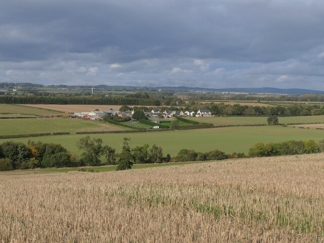
Harpertoun Strip, located in Roxburghshire, Scotland, is a stunning woodland area that stretches across a vast expanse. The strip is nestled within the picturesque region of Roxburghshire, renowned for its natural beauty and rich history.
Covering an area of approximately 10 square kilometers, Harpertoun Strip is predominantly composed of dense forests, with a diverse range of tree species including oak, birch, and pine. The lush vegetation creates a serene ambiance, providing a haven for various wildlife species. Visitors to the area may come across native animals such as red squirrels, roe deer, and a myriad of bird species, making it a popular destination for nature enthusiasts and wildlife photographers alike.
The strip is crisscrossed by numerous walking trails, allowing visitors to explore the woodland at their leisure. These pathways are well-maintained and offer breathtaking views of the surrounding landscape. One notable trail is the Harpertoun Trail, a circular route that takes visitors on a journey through the heart of the forest, highlighting its natural wonders and offering glimpses of the nearby rivers and streams.
In addition to its natural beauty, Harpertoun Strip also boasts historical significance. The area was once part of the hunting grounds of the ancient Scottish kings, and remnants of their hunting lodges can still be seen today. These historical structures provide a glimpse into the region's past and serve as a reminder of its cultural heritage.
Overall, Harpertoun Strip in Roxburghshire is a captivating woodland, offering a harmonious blend of nature and history. Its tranquil atmosphere, diverse wildlife, and scenic trails make it an ideal destination for those seeking a peaceful retreat amidst the enchanting Scottish countryside.
If you have any feedback on the listing, please let us know in the comments section below.
Harpertoun Strip Images
Images are sourced within 2km of 55.652869/-2.4111938 or Grid Reference NT7440. Thanks to Geograph Open Source API. All images are credited.
![Slurry tank at Kennetsideheads One of three large tanks at the farm [2 x ca 20m diam. and 1 x ca 29m diam. all approx 8m high]. So with a volume of approximately 12500m3, and a specific gravity of farm slurry of 0.94, that adds up to about 11750t of slurry!](https://s0.geograph.org.uk/geophotos/07/49/48/7494804_9512a798.jpg)


!['Crannog' at Hassington A modern house adjacent to the farm, built between 2015 and 2020 [as seen from Google Earth].](https://s0.geograph.org.uk/geophotos/07/49/64/7496408_fc925f13.jpg)


Harpertoun Strip is located at Grid Ref: NT7440 (Lat: 55.652869, Lng: -2.4111938)
Unitary Authority: The Scottish Borders
Police Authority: The Lothians and Scottish Borders
What 3 Words
///confusion.frozen.tests. Near Kelso, Scottish Borders
Nearby Locations
Related Wikis

Eccles, Scottish Borders
Eccles (Scottish Gaelic: An Eaglais. Brythonic/Welsh: Eglwys) is a village and agricultural parish near Kelso in Berwickshire in the Scottish Borders area...

Ednam
Ednam is a small village near Kelso in the Scottish Borders area of Scotland. Places nearby include Stichill, Sprouston, Nenthorn, Eccles, Gordon, Greenlaw...
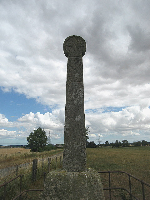
Crosshall cross
The Crosshall Cross is a cross at Crosshall Farm, Eccles, in the Scottish Borders area of Scotland, in historic Berwickshire. The cross is situated near...
Ednam Church
Ednam Church is a member church (Scots: kirk) of the Church of Scotland and is co–joined with Kelso North Church in Kelso. Ednam is in the old county of...
Nearby Amenities
Located within 500m of 55.652869,-2.4111938Have you been to Harpertoun Strip?
Leave your review of Harpertoun Strip below (or comments, questions and feedback).