Leithope Forest

Wood, Forest in Roxburghshire

Scotland

Leithope Forest

Leap Hill Bagged with Adrian Dust after parking at Carter Bar. Wooplaw Edge, Leap Hill, Hungry Law, Greyhound Law and then Ravens Knowe before heading to the Cottonshope road to walk back to collect Dusty's car from the campsite opposite this road beside the A68.
Name: Leap Hill
Hill number: 15929
Height: 471m / 1545ft
Parent (Ma/M): 2302  The Cheviot
Section: 33: The Scottish Border to the River Tyne
Section: 28B: The River Tweed to the English Border
Area: The Cheviots
County/UA: Scottish Borders (UA)
County/UA: Northumberland (CoU)
Class: Tump (400-499m)
Grid ref: NT 72880 07023
Summit feature: fence corner
Drop: 45m
Col: 426m  NT734073
Leap Hill Credit: Rude Health

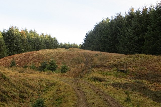
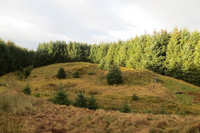
Leithope Forest is a picturesque woodland located in Roxburghshire, Scotland. Spanning over an area of approximately 500 acres, it is a popular destination for nature enthusiasts and outdoor adventurers alike. The forest is situated near the village of Jedburgh, offering easy access to visitors from both nearby towns and further afield.

The woodland is primarily composed of native broadleaf trees, including oak, birch, and beech, which create a diverse and vibrant ecosystem. The forest floor is adorned with a carpet of wildflowers and ferns, adding to the natural beauty of the surroundings. A network of well-maintained trails winds through the forest, providing opportunities for hiking, walking, and exploring.

Leithope Forest is home to a wide variety of wildlife, making it a haven for nature lovers. Visitors may encounter red squirrels, roe deer, and a plethora of bird species, including woodpeckers and owls. The tranquil atmosphere of the forest, coupled with the melodic sounds of nature, creates a serene ambiance that allows visitors to immerse themselves in the wilderness.

A notable feature of Leithope Forest is the presence of the Leithope Burn, a charming stream that meanders through the woodland. The babbling brook adds to the enchanting atmosphere and provides a peaceful spot for picnics or moments of reflection.

Overall, Leithope Forest in Roxburghshire offers a serene and scenic escape from the hustle and bustle of everyday life. It provides an opportunity to reconnect with nature, explore the diverse flora and fauna, and enjoy the tranquility of the Scottish countryside.

If you have any feedback on the listing, please let us know in the comments section below.

Leithope Forest Images

Images are sourced within 2km of 55.37013/-2.4143927 or Grid Reference NT7308. Thanks to Geograph Open Source API. All images are credited.

Leap Hill Bagged with Adrian Dust after parking at Carter Bar. Wooplaw Edge, Leap Hill, Hungry Law, Greyhound Law and then Ravens Knowe before heading to the Cottonshope road to walk back to collect Dusty's car from the campsite opposite this road beside the A68.
Name: Leap Hill
Hill number: 15929
Height: 471m / 1545ft
Parent (Ma/M): 2302  The Cheviot
Section: 33: The Scottish Border to the River Tyne
Section: 28B: The River Tweed to the English Border
Area: The Cheviots
County/UA: Scottish Borders (UA)
County/UA: Northumberland (CoU)
Class: Tump (400-499m)
Grid ref: NT 72880 07023
Summit feature: fence corner
Drop: 45m
Col: 426m  NT734073
Leap Hill
Bagged with Adrian Dust after parking at Carter Bar. Wooplaw Edge, Leap Hill, Hungry Law, Greyhound Law and then Ravens Knowe before heading to the Cottonshope road to walk back to collect Dusty's car from the campsite opposite this road beside the A68. Name: Leap Hill Hill number: 15929 Height: 471m / 1545ft Parent (Ma/M): 2302 The Cheviot Section: 33: The Scottish Border to the River Tyne Section: 28B: The River Tweed to the English Border Area: The Cheviots County/UA: Scottish Borders (UA) County/UA: Northumberland (CoU) Class: Tump (400-499m) Grid ref: NT 72880 07023 Summit feature: fence corner Drop: 45m Col: 426m NT734073
View Towards Fairwood Fell En route between Leap Hill and Hungry Law in the Cheviot Hills.
View Towards Fairwood Fell
En route between Leap Hill and Hungry Law in the Cheviot Hills.
Hunter's Pike Cairn Hunter's Pike Cairn is not far from the summit of Leap Hill.
Hunter's Pike Cairn
Hunter's Pike Cairn is not far from the summit of Leap Hill.
Looking Back Towards Fairwood Fell En route between Leap Hill and Hungry Law in the Cheviot Hills.
Looking Back Towards Fairwood Fell
En route between Leap Hill and Hungry Law in the Cheviot Hills.
Fawhope Rig Five TUMP circuit from Upper Hindhope with Smudge. Fawhope Rig, Goshen Hill, Philip Law, Heugh Law and Loddan Hill.
Name: Fawhope Rig
Hill number: 13956
Height: 372m / 1220ft
Parent (Ma/M): 2302  The Cheviot
Section: 28B: The River Tweed to the English Border
County/UA: Scottish Borders (UA)
Class: Tump (300-399m)
Grid ref: NT 74409 09798
Summit feature: no feature: grass
Drop: 43m
Col: 329m  NT737094
Fawhope Rig
Five TUMP circuit from Upper Hindhope with Smudge. Fawhope Rig, Goshen Hill, Philip Law, Heugh Law and Loddan Hill. Name: Fawhope Rig Hill number: 13956 Height: 372m / 1220ft Parent (Ma/M): 2302 The Cheviot Section: 28B: The River Tweed to the English Border County/UA: Scottish Borders (UA) Class: Tump (300-399m) Grid ref: NT 74409 09798 Summit feature: no feature: grass Drop: 43m Col: 329m NT737094
Approaching Ephope Law Approaching Ephope Law en route between Fawhope Rig and Philip Law.
Approaching Ephope Law
Approaching Ephope Law en route between Fawhope Rig and Philip Law.
Path Through Forest Near Ephope Law Path through forest near Ephope Law used en route between Fawhope Rig and Philip Law.
Path Through Forest Near Ephope Law
Path through forest near Ephope Law used en route between Fawhope Rig and Philip Law.
Heugh Law from the air South Riccalton farm, with its distinctive tree-lined drive is prominent on the left. Leithope Forest is at the bottom.
Heugh Law from the air
South Riccalton farm, with its distinctive tree-lined drive is prominent on the left. Leithope Forest is at the bottom.
Path, Ephope Law A path up a wide ride continues to the forest edge from the road. The path on Ordnance Survey maps no longer exists, but there is still a way through to Fawhope via this ride and open land.
Path, Ephope Law
A path up a wide ride continues to the forest edge from the road. The path on Ordnance Survey maps no longer exists, but there is still a way through to Fawhope via this ride and open land.
Quarry, Ephope Law View from the path out of the forest down to a road stone quarry.
Quarry, Ephope Law
View from the path out of the forest down to a road stone quarry.
Ephope Law Near the summit. Now above the trees, there are big views from here. The path to Fawhope runs north of the summit, the mapped path no longer exists. You can still get through.
Ephope Law
Near the summit. Now above the trees, there are big views from here. The path to Fawhope runs north of the summit, the mapped path no longer exists. You can still get through.
Path, Ephope Law The path out of the forest runs to the north of the now overgrown mapped path.
Path, Ephope Law
The path out of the forest runs to the north of the now overgrown mapped path.
Ruined outbuildings, Fawhope One of many farms and dwellings lost to the big forests of the Border.
Ruined outbuildings, Fawhope
One of many farms and dwellings lost to the big forests of the Border.
Road, Fawhope
Road, Fawhope
Leithope Forest The fire tower on the maps has long gone.
Leithope Forest
The fire tower on the maps has long gone.
Leithope Forest A broadleaved area beside the Long Burn. This is the second or more generation of trees here.
Leithope Forest
A broadleaved area beside the Long Burn. This is the second or more generation of trees here.
Leithope Forest Deciduous woodland beside the Long Burn. Nearly all the forest is coniferous.
Leithope Forest
Deciduous woodland beside the Long Burn. Nearly all the forest is coniferous.
Leithope Forest A forest road junction amongst young trees. This part of the forest is long established. This is part of an old drove road over the Cheviots.
Leithope Forest
A forest road junction amongst young trees. This part of the forest is long established. This is part of an old drove road over the Cheviots.
Show me another place!

Leithope Forest is located at Grid Ref: NT7308 (Lat: 55.37013, Lng: -2.4143927)

Unitary Authority: The Scottish Borders

Police Authority: The Lothians and Scottish Borders

What 3 Words

///wrenching.interval.fancy. Near Rochester, Northumberland

Nearby Locations

Leithope Forest

Related Wikis

Ramshope

Ramshope is a hamlet and former civil parish, now in the parish of Rochester in Northumberland, England located in Northumberland National Park. It lies...

Raid of the Redeswire

The Raid of the Redeswire, also known as the Redeswire Fray, was a border skirmish between England and Scotland on 7 July 1575 which took place at Carter...

Carter Bar

Carter Bar is a pass in the Cheviot Hills, on the Anglo-Scottish border. It lies east of Carter Fell at the head of Redesdale, and is crossed by the A68...

Chew Green

Chew Green is the site of the ancient Roman encampment, commonly but erroneously called Ad Fines (Latin: The Limits) on the 1885-1900 edition of the Ordnance...

Scottish Borders

The Scottish Borders (Scots: the Mairches, lit. 'the Marches'; Scottish Gaelic: Crìochan na h-Alba) is one of 32 council areas of Scotland. It is bordered...

Edgerston

Edgerston is a village and an estate about 4 miles (6.4 km) north of the Anglo-Scottish border, and 8 miles (13 km) south of Jedburgh in the Scottish Borders...

Pennymuir Roman camps

The Pennymuir Roman camps are situated southeast of Jedburgh in the Scottish Borders area of Scotland, near the Anglo-Scottish border, in the former Roxburghshire...

Whitelee Moor

Whitelee Moor is nature reserve of the Northumberland Wildlife Trust, in Northumberland, England, near Carter Bar. A large part of the moor is blanket...

Have you been to Leithope Forest?

Leave your review of Leithope Forest below (or comments, questions and feedback).