Braes of Kinnermit

Wood, Forest in Aberdeenshire

Scotland

Braes of Kinnermit

Deveron Bridge The bridge over the river Deveron to the west of Turriff seen from the river side.
Deveron Bridge Credit: Ralph Greig

Braes of Kinnermit is a picturesque wood located in Aberdeenshire, Scotland. Situated near the village of Kinnermit, it covers an area of approximately 200 hectares. This enchanting forest is nestled within the rolling hills and lush countryside, offering visitors a tranquil and serene escape from the hustle and bustle of everyday life.

The wood is mainly composed of native tree species, including oak, birch, and pine, which create a diverse and vibrant ecosystem. The dense canopy provides shelter to a variety of wildlife, such as red squirrels, roe deer, and a wide range of bird species. Nature enthusiasts can explore the well-maintained trails that wind through the wood, allowing them to immerse themselves in the natural beauty of the area.

In addition to its natural splendor, Braes of Kinnermit boasts a rich cultural history. The wood was once part of an estate owned by a local laird, and remnants of historic structures, such as old walls and ruins, can still be found scattered throughout the area. These remnants serve as a testament to the past and add an intriguing element to the wood's charm.

Braes of Kinnermit is a popular destination for outdoor activities such as hiking, birdwatching, and nature photography. Visitors can also enjoy picnicking amidst the stunning scenery or simply take a leisurely stroll along the tranquil paths. With its beauty, biodiversity, and historical significance, Braes of Kinnermit is truly a hidden gem in Aberdeenshire, offering a peaceful retreat for nature lovers and history enthusiasts alike.

If you have any feedback on the listing, please let us know in the comments section below.

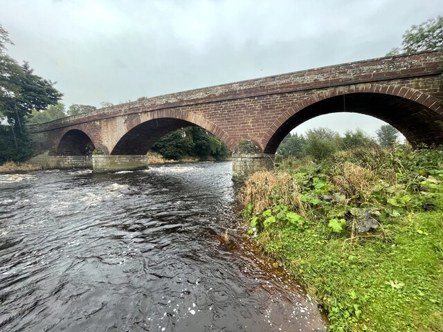
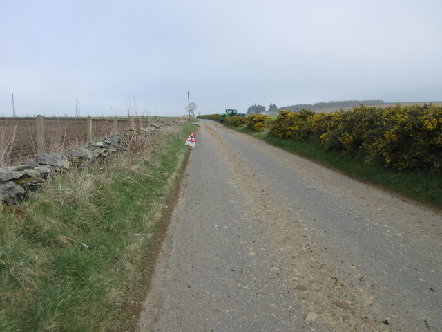
Braes of Kinnermit Images

Images are sourced within 2km of 57.53717/-2.472782 or Grid Reference NJ7149. Thanks to Geograph Open Source API. All images are credited.

Deveron Bridge The bridge over the river Deveron to the west of Turriff seen from the river side.
Deveron Bridge
The bridge over the river Deveron to the west of Turriff seen from the river side.
Horse at Knockiemill Single horse in a field by the roadside to the north of Knockiemill.
Horse at Knockiemill
Single horse in a field by the roadside to the north of Knockiemill.
Dry mud on the C5S (Aberdeenshire) Road Mud on the road with farming taking place near Claymires to the north of Turriff.
Dry mud on the C5S (Aberdeenshire) Road
Mud on the road with farming taking place near Claymires to the north of Turriff.
Turriff Primary School Looking south-west to Turriff Primary School on the northern outskirts of the town.
Turriff Primary School
Looking south-west to Turriff Primary School on the northern outskirts of the town.
Market Street, Turriff Looking south down Market Street in Turriff.
Market Street, Turriff
Looking south down Market Street in Turriff.
Markethill Trig Pillar The triangulation pillar hidden away on the north side of a water treatment compound at Markethill on the north-east outskirts of Turriff.
Markethill Trig Pillar
The triangulation pillar hidden away on the north side of a water treatment compound at Markethill on the north-east outskirts of Turriff.
Deveron Bridge
Deveron Bridge
The Turra Coo The Turra Coo (Doric for "the Turriff Cow") was a white Ayrshire-Shorthorn cross dairy cow which lived near the Aberdeenshire town of Turriff in north-east Scotland in the early twentieth century. The cow became famous following a dispute between her owner, supported by local people, against the government over taxes and compulsory national insurance.
The Turra Coo
The Turra Coo (Doric for "the Turriff Cow") was a white Ayrshire-Shorthorn cross dairy cow which lived near the Aberdeenshire town of Turriff in north-east Scotland in the early twentieth century. The cow became famous following a dispute between her owner, supported by local people, against the government over taxes and compulsory national insurance.
Forest Friends 
Art Trail 


Hare, there and everywhere!
Clan Cancer Support, the north-east’s leading cancer support charity, has partnered with Wild in Art once again to bring an exciting new art trail to the north-east, Moray, Orkney and Shetland.

The Big Hop Trail will take the public on another cultural tour of the north-east and the islands from July to September 2023, with hare sculptures designed and created by some of the country’s most talented artists.

The trail coincides with Clan’s 40th anniversary, with the 40 hares being the focal point to celebrate the charity’s commitment to supporting people affected by cancer. 

We chose the hare sculpture as they are an indigenous animal found in all parts of Clan’s geography. Much like our clients during their cancer journey, hares have to navigate rough and difficult terrain in order to survive. They are also adaptable, like our services team who deliver support to anyone affected by cancer. Most importantly, hares have incredible hearing. What better way to depict our lifeline listening and support service and the importance of being heard?
Forest Friends
Art Trail Hare, there and everywhere! Clan Cancer Support, the north-east’s leading cancer support charity, has partnered with Wild in Art once again to bring an exciting new art trail to the north-east, Moray, Orkney and Shetland. The Big Hop Trail will take the public on another cultural tour of the north-east and the islands from July to September 2023, with hare sculptures designed and created by some of the country’s most talented artists. The trail coincides with Clan’s 40th anniversary, with the 40 hares being the focal point to celebrate the charity’s commitment to supporting people affected by cancer. We chose the hare sculpture as they are an indigenous animal found in all parts of Clan’s geography. Much like our clients during their cancer journey, hares have to navigate rough and difficult terrain in order to survive. They are also adaptable, like our services team who deliver support to anyone affected by cancer. Most importantly, hares have incredible hearing. What better way to depict our lifeline listening and support service and the importance of being heard?
Track to Southend Track leading to the house at Southend after a heavy shower.
Track to Southend
Track leading to the house at Southend after a heavy shower.
C22S heading up the hill southwards The C22S road heading up the hill south from Turriff.
C22S heading up the hill southwards
The C22S road heading up the hill south from Turriff.
Old Bridge of Turriff Looking to the old from the new bridge over the Burn of Turriff.
Old Bridge of Turriff
Looking to the old from the new bridge over the Burn of Turriff.
Turra Display A display by the White Helmets team during the annual Turriff Show at the Haughs.
Turra Display
A display by the White Helmets team during the annual Turriff Show at the Haughs.
Sulkies at Turriff Sulky racing in the showground at the Haughs during Turriff's annual show.
Sulkies at Turriff
Sulky racing in the showground at the Haughs during Turriff's annual show.
Steam Up The more commercial side of Turriff Show.
Steam Up
The more commercial side of Turriff Show.
St Andrew's Church Hall The church hall on Ballmellie Road was used as an auxiliary hospital during the Great War.
St Andrew's Church Hall
The church hall on Ballmellie Road was used as an auxiliary hospital during the Great War.
Mercat cross, Turriff Dating from 1865 in a prominent location at the end of the High Street and replacing the medieval original.  Listed building designation LB42167: <span class="nowrap"><a title="http://portal.historicenvironment.scot/designation/LB42167" rel="nofollow ugc noopener" href="http://portal.historicenvironment.scot/designation/LB42167">Link</a><img style="margin-left:2px;" alt="External link" title="External link - shift click to open in new window" src="https://s1.geograph.org.uk/img/external.png" width="10" height="10"/></span> .
Mercat cross, Turriff
Dating from 1865 in a prominent location at the end of the High Street and replacing the medieval original. Listed building designation LB42167: LinkExternal link .
Putachie Path, Turriff The unusually-named street plunges sharply down past the early 19th Century C-listed cottages: <span class="nowrap"><a title="http://portal.historicenvironment.scot/designation/LB42165" rel="nofollow ugc noopener" href="http://portal.historicenvironment.scot/designation/LB42165">Link</a><img style="margin-left:2px;" alt="External link" title="External link - shift click to open in new window" src="https://s1.geograph.org.uk/img/external.png" width="10" height="10"/></span> (listed building designation LB42165).
Putachie Path, Turriff
The unusually-named street plunges sharply down past the early 19th Century C-listed cottages: LinkExternal link (listed building designation LB42165).
Show me another place!

Braes of Kinnermit is located at Grid Ref: NJ7149 (Lat: 57.53717, Lng: -2.472782)

Unitary Authority: Aberdeenshire

Police Authority: North East

What 3 Words

///dispensed.passports.shepherdess. Near Turriff, Aberdeenshire

Nearby Locations

Braes of Kinnermit

Related Wikis

Turriff United F.C.

Turriff United Football Club are a senior football club currently playing in the Highland Football League in Scotland. They play their matches at The Haughs...

Turriff Castle

Turriff Castle was a tower house, on Castlegate, Turriff, north of Idoch Water, Aberdeenshire, Scotland. The castle was also called Tower of Torrey of...

Turriff Academy

Turriff Academy is a non denominational comprehensive co-educational secondary school located in Turriff, Aberdeenshire, Scotland. It serves a large catchment...

Turriff

Turriff (from Scottish Gaelic Torraibh 'place of round hills') is a town and civil parish in Aberdeenshire in Scotland. It lies on the River Deveron,...

Nearby Amenities

Located within 500m of 57.53717,-2.472782
Spar
Brand: Spar
Brand Wikidata: Q610492
Shop: convenience
Lat/Long: 57.5389897/-2.4674393
Post Box
Postal Code: AB53
Ref: AB53 10
Source: survey
Lat/Long: 57.5392932/-2.4666609
Hendersons Country Sports
Shop: sports
Sport: shooting
Lat/Long: 57.5373876/-2.4644324
Royal Oak Hotel
Addr City: Turriff
Addr Housenumber: 16
Addr Street: Deveron Street
Contact Facebook: https://www.facebook.com/royal.oak.505
Phone: +44 1888 568252
Tourism: hotel
Lat/Long: 57.5389255/-2.4677999
Power: pole
Lat/Long: 57.5329739/-2.4709284
Power: pole
Lat/Long: 57.533532/-2.471101
Power: pole
Lat/Long: 57.5336903/-2.4711468
Power: pole
Lat/Long: 57.5339827/-2.4720715
Power: pole
Lat/Long: 57.5344016/-2.4734376
Power: pole
Lat/Long: 57.5347364/-2.4745153
Power: pole
Lat/Long: 57.5350677/-2.4756063
Power: pole
Lat/Long: 57.5354097/-2.476722
Power: pole
Lat/Long: 57.5356953/-2.4776364
Power: pole
Lat/Long: 57.5356137/-2.4802411
Power: pole
Lat/Long: 57.5361202/-2.4796621
Power: pole
Lat/Long: 57.5366266/-2.4790964
Power: pole
Lat/Long: 57.5370347/-2.4786806
Power: pole
Lat/Long: 57.5375147/-2.4781909
Power: pole
Lat/Long: 57.5380079/-2.4777259
Power: pole
Lat/Long: 57.5385143/-2.4771982
Power: pole
Lat/Long: 57.5391707/-2.4762905
Power: pole
Lat/Long: 57.5397263/-2.4755437
Power: pole
Lat/Long: 57.5401499/-2.4749557
Power: pole
Lat/Long: 57.5371547/-2.4781842
Power: pole
Lat/Long: 57.5365138/-2.477936
Power: pole
Lat/Long: 57.5351397/-2.4774218
Power: pole
Lat/Long: 57.5345732/-2.4772161
Bus Stop
Muiresk Drive
Bus: yes
Naptan AtcoCode: 630024914
Naptan Bearing: SE
Naptan CommonName: Muiresk Drive
Naptan Indicator: opp
Naptan NaptanCode: 23634592
Naptan Street: Deveron Road
Naptan Verified: no
Public Transport: platform
Source: naptan;bing;naptan_compare_tool
Lat/Long: 57.541339/-2.4718602
The data included in this document is from www.openstreetmap.org. The data is made available under ODbL.

Have you been to Braes of Kinnermit?

Leave your review of Braes of Kinnermit below (or comments, questions and feedback).